

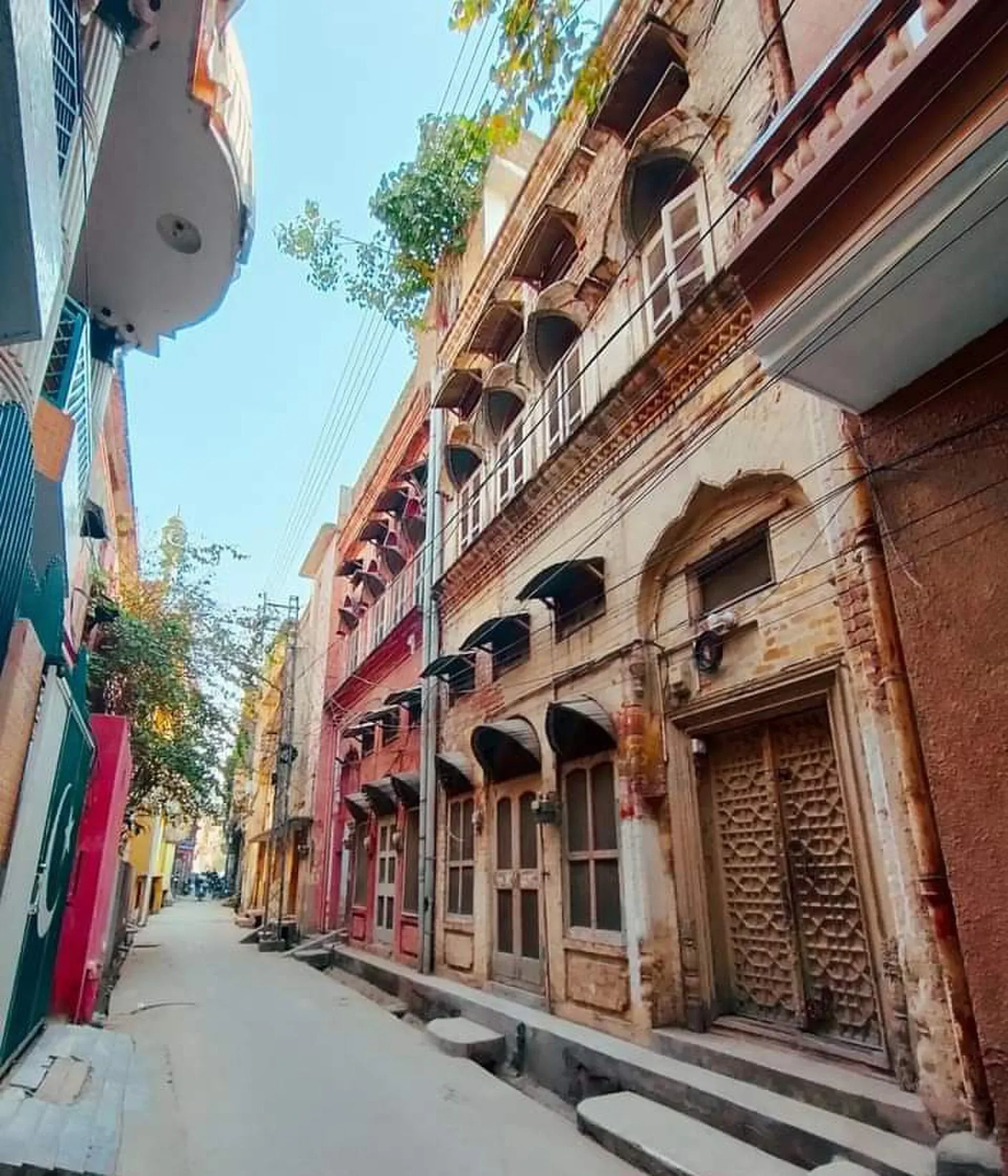
Photo: Fahads1982, with thanks · CC BY-SA 4.0 · via Wikimedia Commons · temporary stand-in photo

Rawalpindi
Islamabad's older twin city: a busy bazaar and cantonment, the north's main rail and bus hub, and an easy base for Taxila and Murree.
Overview
Rawalpindi sits on the Pothohar Plateau about 15 km south-west of Islamabad, and the two cities form one urban area. Rawalpindi is the older, busier twin, with a crowded old bazaar, a British-era cantonment and the headquarters of the Pakistan Army. It is also the main rail and bus hub for the north. Many travellers pass through on the way to the Karakoram Highway, Murree and Azad Kashmir.
Plan your visit
- Getting there
Air: Islamabad International Airport (ISB), about 30 km. Rail: Rawalpindi Junction. Road: Grand Trunk Road, M-2 and N-35 Karakoram Highway via Hasan Abdal. More
Best months
Mar – Apr, Oct – Nov
- Rawalpindi
- Related places nearby: Islamabad, Rawat Fort, Rawalpindi, Sangni Fort, Pakistan Railways Heritage Museum (Golra Sharif), Gujar Khan
History in brief
Wikipedia records that the older town, called Fatehpur Baori, declined after the Mongol invasions of the 14th century. The Gakhar chief Jhanda Khan restored it in 1493 and named it Rawalpindi, "the village of Rawal". The Mughals held the area, and Akbar stayed nearby for about 13 years from 1585.
Sikh forces took the town in 1767, and the Sikh commanders surrendered to the British in March 1849. Lord Dalhousie approved a permanent cantonment in 1851, and the Garrison Church was built in 1854. The railway reached the city in the 1880s, and in 1901 it became the winter headquarters of the Northern Command. Rawalpindi became the army's headquarters after independence and served as the interim capital in 1959 while Islamabad was built.
Bazaars and what they sell
- Raja Bazaar and the old city: a dense warren of wholesale and retail markets, with older havelis and mosques. It is the cheapest market in the city, and easy to get lost in, so a map helps.
- Moti Bazaar: known for clothes and artificial jewellery.
- Saraf Bazaar: the main gold market, known for its designs.
- Purana Qila: known for wedding clothes.
- Saddar and the Mall: wide roads, colonial-era buildings, shops and hotels. Saddar grew up as the cantonment's shopping district.
- Committee Chowk and Murree Road: busy corridors with the Metro Bus, hotels and more jewellers.
- Cantonment (Cantt): quiet and well-kept, with parks and wide roads.
- Satellite Town and Bahria Town: newer residential suburbs with restaurants and malls.
Top sights
- Raja Bazaar: the main old market. Go in the morning, on foot, and keep your bag close.
- Liaquat Bagh: the large park near the Mall, formerly the East India Company's garden. Prime Minister Liaquat Ali Khan was assassinated here in 1951 and Benazir Bhutto in 2007. Wikipedia lists it as run by the Parks and Horticulture Authority (PHA) Rawalpindi, with its own Metrobus station; no hours are published.
- Christ Church and the Mall: a short stroll past colonial-era churches and buildings in Saddar.
- Pakistan Army Museum: covers the Pakistan Army and the British Indian Army, and was established in 1961 according to Wikivoyage. Check opening arrangements before going.
- Ayub National Park: a large park of about 2,300 acres, with a lake, playgrounds and picnic lawns. The Army Heritage Foundation runs it; its website gives a phone and email but no hours or entry rules.
- Golra Sharif shrine (Islamabad side): a Sufi shrine on the edge of the twin cities; visit respectfully.
- Rawal Lake and Rawal Dam (Islamabad side): a short ride for sunset and boating.
- Rawat Fort: a 16th-century fortified caravanserai (a fortified roadside inn) off the Grand Trunk Road, about 15 km from the city.
- Mankiala Stupa and Rohtas Fort: two heritage sites an easy day trip away.
- Pharwala Fort: a fort on the edge of the Pothohar plateau, about 40 km from Rawalpindi near Kahuta. Wikipedia says it was restored after conservation work began in September 2023 and declared open to the public in January 2024; road and access details were not found.
Food
Rawalpindi has a strong street-food and kebab culture. Try the seekh kebab and chapli kebab, dahi bhalla, sweet lassi and tandoori naan from old bakers. Wikivoyage lists jalebi (a fried syrup sweet), samosas, rabri (thickened sweet milk) and chaat such as gol gappay and fruit chaat among the local snacks. Breakfast is traditionally halwa puri and chana, with a well-known area for it in Satellite Town.
Cold drinks include tamarind and plum sharbat, sugar-cane juice and shakar kola, a brown-sugar drink. Eat at busy stalls with fast turnover and choose freshly cooked items.
A day in the twin cities
One workable outline, built from the sights above:
- Morning: breakfast of halwa puri, then walk Raja Bazaar and the old lanes before the crowds build.
- Midday: take the Metro Bus to Saddar, then walk the Mall past Christ Church and the colonial-era streets. Visit the Army Museum if it is open.
- Late afternoon: ride the Metro Bus to Islamabad for Rawal Lake or the Margalla viewpoints.
- Evening: chaat, kebabs and sweets around Committee Chowk and Murree Road.
With a second day, Taxila and Rawat Fort fit together, or Murree if the weather is clear.
Getting there
- By air: Islamabad International Airport (ISB) is about 30 km away.
- By rail: Rawalpindi Junction is in Saddar on the Karachi to Peshawar main line and has services to Lahore, Karachi, Peshawar and Quetta. Book through Pakistan Railways.
- By road: the Grand Trunk Road runs through the city, the M-2 starts near Islamabad, and the Karakoram Highway can be joined at Hasan Abdal. Intercity coaches leave from Pir Wadhai, which Wikipedia calls the country's largest public intercity bus terminal, and from other terminals.
Getting around
The Rawalpindi-Islamabad Metro Bus Red Line links Saddar with Islamabad's Pak Secretariat (about 22.5 km, 24 stations) and is quick and cheap. Wikipedia lists service hours as 06:15 to 22:00; check before relying on late trips. Ride-hailing and rickshaws fill the gaps. The centre around Raja Bazaar is walkable. Traffic is heavy around Murree Road, so allow extra time.
Where to stay
- Saddar and Murree Road: many budget and mid-range hotels, convenient for the bus terminals and Metro Bus.
- Cantonment and Bahria Town: quieter and generally more upscale.
- Islamabad: many travellers stay there for more space and greener streets, and use Rawalpindi for transport and food.
When to visit
Spring and autumn are the most comfortable. The climate is humid subtropical. Wikipedia gives a mean June daily maximum of 38.4 C, and monsoon rain peaks in July and August, which average over 300 mm each. January days average about 18 C, with cold nights.
Safety and etiquette
The city is crowded, so watch for pickpockets in bazaars and keep large notes out of sight. Expect security checkpoints around the cantonment and military areas, and photography near military sites is not allowed. Dress modestly and take extra care around demonstrations. Check the current security situation before you go.
Day trips
- Islamabad and the Margalla Hills (30 minutes).
- Taxila (about 30 km), a UNESCO World Heritage site.
- Murree (about 55 km), a hill station.
- Rawat Fort (about 15 km off the Grand Trunk Road).
- Rohtas Fort (about 100 km).
- Katas Raj and the Salt Range (about 150 km).
Good to know
A fee applies at some parks and museums; current fees will be added soon. Check at the gate or with the relevant authority.
Highlights
- Raja Bazaar and the old city
- Street food and kebabs
- Rail and bus hub for the north
- Close to Taxila, Murree and Rohtas Fort
Hotels, food, fuel and services in Rawalpindi
Places to stay
- Avari Xpress Residences Islamabad HotelCall Avari Xpress Residences Islamabad HotelMap of Avari Xpress Residences Islamabad Hotel in Google Maps
- Best Western Premier IslamabadCall Best Western Premier IslamabadMap of Best Western Premier Islamabad in Google Maps
- RISING SUN LODGESCall RISING SUN LODGESMap of RISING SUN LODGES in Google Maps
- Infantry Officer's MessCall Infantry Officer's MessMap of Infantry Officer's Mess in Google Maps
- Go Glam Hotel Salon Spa (PVT LTD)Call Go Glam Hotel Salon Spa (PVT LTD)Map of Go Glam Hotel Salon Spa (PVT LTD) in Google Maps
- Hotel Eden RockCall Hotel Eden RockMap of Hotel Eden Rock in Google Maps
Places to eat
- TKR 3Call TKR 3Map of TKR 3 in Google Maps
- Savour FoodsCall Savour FoodsMap of Savour Foods in Google Maps
- Cheezious Commercial MarketCall Cheezious Commercial MarketMap of Cheezious Commercial Market in Google Maps
- Savour FoodsCall Savour FoodsMap of Savour Foods in Google Maps
- Tehzeeb BakersCall Tehzeeb BakersMap of Tehzeeb Bakers in Google Maps
- McDonald'sCall McDonald'sMap of McDonald's in Google Maps
Essential services fuel stations, mechanics, pharmacies and hospitals and clinics
Fuel
- Attock Petrol PumpMap of Attock Petrol Pump in Google Maps
- PSO Petrol PumpMap of PSO Petrol Pump in Google Maps
- Attock Petrol PumpCall Attock Petrol PumpMap of Attock Petrol Pump in Google Maps
- Byco Petrol Pump (Range Road)Map of Byco Petrol Pump (Range Road) in Google Maps
- PSO Petrol PumpCall PSO Petrol PumpMap of PSO Petrol Pump in Google Maps
- PSO Fuel StationMap of PSO Fuel Station in Google Maps
Mechanics and tyre shops
- Mohammed Bilal tyre centreMap of Mohammed Bilal tyre centre in Google Maps
- Toyota GT MotorsCall Toyota GT MotorsMap of Toyota GT Motors in Google Maps
- Polygon CastCall Polygon CastMap of Polygon Cast in Google Maps
Pharmacies
- Imtiaz Mega - Ramzan Mall - islamabadCall Imtiaz Mega - Ramzan Mall - islamabadMap of Imtiaz Mega - Ramzan Mall - islamabad in Google Maps
- D.WATSON CHEMIST F-11 MARKAZCall D.WATSON CHEMIST F-11 MARKAZMap of D.WATSON CHEMIST F-11 MARKAZ in Google Maps
- Shaheen Chemist I-8 MarkazCall Shaheen Chemist I-8 MarkazMap of Shaheen Chemist I-8 Markaz in Google Maps
- Shaheen ChemistCall Shaheen ChemistMap of Shaheen Chemist in Google Maps
Hospitals and clinics
- Shifa International Hospitals LimitedCall Shifa International Hospitals LimitedMap of Shifa International Hospitals Limited in Google Maps
- Amanat Eye Hospital RawalpindiCall Amanat Eye Hospital RawalpindiMap of Amanat Eye Hospital Rawalpindi in Google Maps
- Maryam Memorial Hospital (MMH)Call Maryam Memorial Hospital (MMH)Map of Maryam Memorial Hospital (MMH) in Google Maps
- Combined Military Hospital Rawalpindi (CMH)Call Combined Military Hospital Rawalpindi (CMH)Map of Combined Military Hospital Rawalpindi (CMH) in Google Maps
- Advanced International Hospital IslamabadCall Advanced International Hospital IslamabadMap of Advanced International Hospital Islamabad in Google Maps
- Brain Surgery HospitalCall Brain Surgery HospitalMap of Brain Surgery Hospital in Google Maps
Listings come from Google Maps data and are unverified: phone numbers, opening months and prices may have changed. Report a problem · Own one of these? Claim it
Tips
- Use the Metro Bus between Saddar and Islamabad.
- Visit bazaars in the morning.
- Watch your belongings in crowds.
- Do not photograph military sites.
Photos we still need: a dish or street-food stall in Raja Bazaar or Committee Chowk (current photo shows Saddar food street). Send us yours
Sources and last checked
Last checked Confidence medium12 sources3 still to check
- Last checked
- Method
- Desk research from published sources
- Confidence
- medium
- Checked by
- trek.pk research team
Researched from published sources; not yet checked on the ground by our team. Spot something out of date? Report a mistake.
Sources
- Rawalpindi · Wikipedia · checked
- Pakistan Railways · Ministry of Railways · checked
- Old trek.pk Rawalpindi page (facts only) · trek.pk · checked
- Islamabad Capital Territory (Metrobus, airport) · Wikipedia · checked
- List of cities in Pakistan by population (2023 census) · Wikipedia · checked
- Liaquat Bagh · Wikipedia · checked
- Ayub National Park · Wikipedia · checked
- Pharwala Fort · Wikipedia · checked
- Pir Wadhai · Wikipedia · checked
- Rawalpindi-Islamabad Metrobus · Wikipedia · checked
- Rawalpindi · Wikivoyage · checked
- Liaquat Ali Khan · Wikipedia · checked
Still to be checked on the ground (3)
- Other intercity bus terminal locations (only Pir Wadhai confirmed by Wikipedia, a stub article)
- Pharwala Fort road access and visiting rules (Wikipedia: open to the public since January 2024, about 40 km from Rawalpindi)
- Pakistan Army Museum opening days, hours and visitor rules
Nearby and related

Islamabad
Pakistan's green, planned capital at the foot of the Margalla Hills: Faisal Mosque, hillside trails, cafes and the gateway to the north.

Lahore
Punjab's capital and Pakistan's cultural city: Mughal forts, mosques and gardens, a lively Walled City, and some of the best food in the country.
Rawat Fort, Rawalpindi
A fortified caravanserai on the Grand Trunk Road about 17 km east of Rawalpindi, founded in the 15th century and turned into a Gakhar stronghold in the 16th. On Pakistan's UNESCO tentative list since 2026.
Sangni Fort
A 19th-century Sikh-period fort near Takal village in Kallar Syedan, Rawalpindi district. The walls are intact and the fort now holds the shrine of Sahibzada Abdul Hakeem.

Pakistan Railways Heritage Museum (Golra Sharif)
A railway museum in Golra Sharif Junction station, Islamabad, with steam and electric locomotives, saloon cars and relics from over 150 years of railway history. Open since 2003.
Soan River
A seasonal river of the Pothohar Plateau that rises in the Murree Hills and runs past Islamabad and Rawalpindi to the Indus near Makhad. Its valley gave its name to the Soanian stone-tool culture.
Gujar Khan
Large Pothohar town of about 103,000 people on the N-5 between Islamabad and Jhelum, known for its army tradition and nearby oil and gas fields. Few visitor sights.