

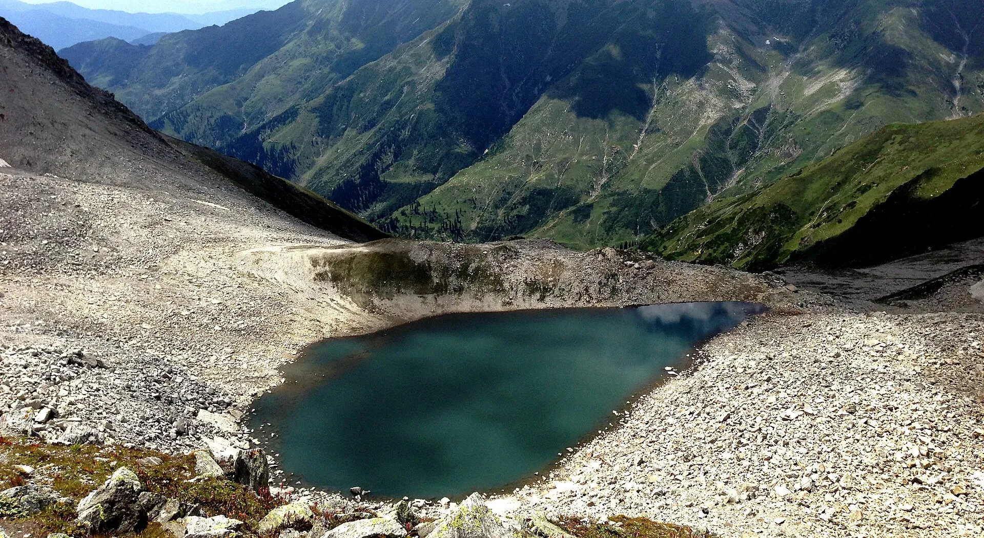
Photo: Sarmad1296ali, with thanks · CC BY-SA 4.0 · via Wikimedia Commons · temporary stand-in photo

Ansoo Lake Trail
- Duration
- 1–2 days
- Grade
- Strenuous
- Max altitude
- 4,126 m
- Season
- Jul – Sep
A hard full-day hike from Saiful Muluk to Ansoo Lake (4,126 m on Wikipedia; guides say up to about 4,260 m) in the Kaghan Valley. Sources give 7 to 12 hours return; go in July and August with a local guide.
Overview
Ansoo Lake (Tear Lake) is a high lake shaped like a tear, above Saiful Muluk in the Kaghan Valley. Wikipedia's Ansoo Lake article gives 4,126 m (13,537 ft), while trekking operators mostly quote 4,245 to 4,260 m; some pages give 5,027 m (16,490 ft), which does not fit the rest and is not used here. This page uses the Wikipedia figure and notes the range. Saiful Muluk itself is at 3,224 m (Wikipedia), so the walk climbs roughly 1,000 m. TDAP lists it among the accessible lakes.
Who it suits
Strong, acclimatised hikers. The first half is gentle along a valley, the second half is steep and rough with snow and loose ground. It is not for beginners, small children or anyone who has not spent a night or two at Naran first.
When to go
July to September. The best window quoted is about 10 July to 15 August. The trail is snow-covered for most of the year, and monsoon rain brings landslide risk. Start by 6 am so you are back before dark. Note that in August 2026 the Mansehra district administration allowed visitors to travel to Saiful Muluk only between 9:30 am and 4 pm, and police can close the Naran to Saiful Muluk road at short notice in bad weather. Ask in Naran whether that rule is still in force before you plan an early start.
Access
Naran is the base. From Naran, Saiful Muluk is about 9 km north by road, mostly on a rough jeep track, and jeeps are the normal transport. The walk starts at the lake itself, which sits above the tree line at about 3,224 m. Saiful Muluk takes its name from a folk tale about an Egyptian prince and a fairy princess, later retold as a Sufi poem by Mian Muhammad Bakhsh. In winter heavy snow and landslides can cut the road.
Terrain underfoot
The first half follows a stream up a valley and the ground is easy. After the Malika Parbat base camp the trail becomes steep and stony, then crosses snow and glacier patches, which cover the trail for most of the year. Operators say several glaciers must be crossed and that the narrow track leaves no room for horses on the upper section. Malika Parbat, the highest peak of the Kaghan Valley, rises close to the lake.
The route
From Saiful Muluk you cross to the far side and follow a valley beside a stream towards the base of Malika Parbat. After the base camp area the path climbs steeply to the lake. Time is uncertain: one source says about 4 hours each way, others give 6 to 8, 7 to 8, or more than 12 hours return. One trekking forum breakdown gives about 10 km between Saiful Muluk and the lake, but no official length exists. Plan a full day. Some groups camp near the base camp, across the water from Saiful Muluk, to split the walk. One operator describes a summit at about 14,000 ft from which the lake is visible, about 20 minutes beyond the climb. Ponies and guides are available at Saiful Muluk, but the narrow trail has little room for horses.
From Naran, Saiful Muluk is about 9 km by road (OSRM 21 minutes on the jeep track, longer in practice), and Islamabad to Naran is about 254 km by OSRM.
Preparation
Spend a night or two at Naran first, since the walk reaches above 4,000 m. Start around 6 am and aim to be back at Saiful Muluk before sunset, as hiking in the dark is difficult. Pack warm layers, waterproofs, a sturdy daypack, food and water treatment. Fog or rain often hides the lake, so choose a clear-weather day and ask the guide. Ponies can be hired at Saiful Muluk but cannot use the upper trail.
Alternative approach
One operator describes a route from Mahandri village, about 40 km south of Naran by one source. A jeep goes to Manoor village, and a walk of about 7 hours leads to a meadow called Dher before Ansoo Lake. This approach is long and little documented, so only strong parties with a local guide should consider it.
Culture and people
Kaghan is a popular summer valley with local families and many visitors. Guides and ponies are hired from local people at Saiful Muluk. Respect local rules and keep the lake clean.
Practical information
- Hire a local guide for the tricky sections.
- Check the forecast; weather changes fast.
- Carry a tent only if you plan to camp.
- Distances are not reliably published.
Highlights
- High tear-shaped lake near 4,126 m
- Starts from famous Saiful Muluk
- Views of Malika Parbat
- Guides and ponies at Saiful Muluk
Day by day
- StartSaiful Muluk Lake (3,224 m)
- Day 1Malika Parbat base
- Day 1Ansoo Lake
| Day | Route | Hours | Distance | Ascent / descent | Camp and altitude |
|---|---|---|---|---|---|
| Day 1 | Saiful Muluk to Malika Parbat base | 2–4 h | not given | not given | Malika Parbat base |
Day 1 notesCross to the far side of Saiful Muluk (3,224 m) and follow a valley beside a stream. The path is gentle and the ground is stony. It rises towards the base of Malika Parbat, the highest peak in the Kaghan Valley. Rest here, or camp if you plan two days. | |||||
| Day 1 | Base to Ansoo Lake and return | 4–8 h return (sources vary) | not given | not given | Ansoo Lake, 4,126 m |
Day 1 notesAfter the base camp the climb is steep, over rock, loose stone and snow, with glacier patches. The narrow track has no room for horses. At the top is the tear-shaped Ansoo Lake. Return the same way and aim to be back at Saiful Muluk before dark; fog or rain can hide the lake. | |||||
Getting there
Naran is about 9 to 10 hours by road from Lahore and 6 to 7 hours from Islamabad. From Naran, Saiful Muluk is about 9 km; the jeep road is rough and jeeps are the normal transport. The walk starts from the lake. Roads are cut by snow and landslides in winter and monsoon.
Permits and rules
- Permit needed
- Usually not, Open zone
- Fee
- Current fees will be added soon
- Last checked
- 16 November 2026
No confirmed official fee or permit was found for the trail. Saiful Muluk is in a national park, so a park or access fee may apply: current fees will be added soon. Check with Kaghan or Naran tourism officials.
How trekking permits, NOCs and registration work: Visa and permits.
Season
Best: Jul – Sep
Water and camps
Streams flow in the valley in summer; treat water before drinking. Camp near the base area below the final climb if you stay out. A reliable tent is needed.
Gear and safety
Altitude
You climb above 4,000 m. Know the signs of altitude sickness (headache, nausea, breathlessness) and descend if they appear.
Weather and snow
Snow and glaciers persist into summer, and weather can turn quickly. Check forecasts and keep to the guide's advice.
Landslides
Monsoon rain can bring landslides on the road and trail.
Rescue
Mobile signal is poor. Tell someone your plan and hire a guide.
Ask the district administration or local police about current conditions before you go. For foreign visitors: the UK FCDO does not name the Kaghan valley, but it advises against all travel on the Karakoram Highway between Mansehra and Chilas (advice updated 27 October 2026, checked 16 November 2026). Most visitors reach Kaghan by the N-15 from Mansehra, not the KKH. Read the live advice before you plan.
Variations
From Saiful Muluk you can also walk to Dudipatsar or Saral lakes on other days. Some people approach Ansoo from the Mahandri side (long, less documented).
Tips
- Spend a night at Naran first to adjust to altitude
- Leave at 6 am and turn back if cloud builds
- Hire a guide
- Carry sunglasses and warm layers
- Ask in Naran about the current Saiful Muluk visiting hours (9:30 am to 4 pm was enforced in August 2026) before planning a 6 am start
Stay and eat in Naran
Naran is the nearest town to the trek: somewhere to sleep and stock up before and after.
Places to stay
- HOTEL deMANCHICall HOTEL deMANCHIMap of HOTEL deMANCHI in Google Maps
- Fairy Meadows HotelCall Fairy Meadows HotelMap of Fairy Meadows Hotel in Google Maps
- Mount Feast Hotel NaranCall Mount Feast Hotel NaranMap of Mount Feast Hotel Naran in Google Maps
- Serene Resorts NaranCall Serene Resorts NaranMap of Serene Resorts Naran in Google Maps
- Northern Retreat by Hotel DemanchiCall Northern Retreat by Hotel DemanchiMap of Northern Retreat by Hotel Demanchi in Google Maps
- New Park Hotel & RestaurantCall New Park Hotel & RestaurantMap of New Park Hotel & Restaurant in Google Maps
Places to eat
- Moon RestaurantCall Moon RestaurantMap of Moon Restaurant in Google Maps
- SubwayCall SubwayMap of Subway in Google Maps
- Bar B.Q. Tonight Restaurant NARANCall Bar B.Q. Tonight Restaurant NARANMap of Bar B.Q. Tonight Restaurant NARAN in Google Maps
- N-15 Cafe & DeliCall N-15 Cafe & DeliMap of N-15 Cafe & Deli in Google Maps
- Al Noor Restaurant NaranCall Al Noor Restaurant NaranMap of Al Noor Restaurant Naran in Google Maps
Essential services fuel stations, mechanics and banks
Fuel
- PSO Petrol Pump Sajjad Fill StationCall PSO Petrol Pump Sajjad Fill StationMap of PSO Petrol Pump Sajjad Fill Station in Google Maps
- Pakistan State Oil - Yasir Haroon Filling StationCall Pakistan State Oil - Yasir Haroon Filling StationMap of Pakistan State Oil - Yasir Haroon Filling Station in Google Maps
- FLOW PETROLIUMCall FLOW PETROLIUMMap of FLOW PETROLIUM in Google Maps
Mechanics and tyre shops
- Baig Suzuki center& Rental Bike NaranMap of Baig Suzuki center& Rental Bike Naran in Google Maps
Banks and money exchange
- Allied Bank LimitedMap of Allied Bank Limited in Google Maps
Listings come from Google Maps data and are unverified: phone numbers, opening months and prices may have changed. Report a problem · Own one of these? Claim it
Photos we still need: Saiful Muluk start, the stream valley, Malika Parbat base camp and the final climb. Send us yours
Health and emergency
Mobile signal is patchy on most treks, so tell someone your plan before you go. Emergency numbers
Sources and last checked
Last checked Confidence medium11 sources5 still to check
- Last checked
- Method
- Desk research from published sources
- Confidence
- medium
- Checked by
- trek.pk research team
Researched from published sources; not yet checked on the ground by our team. Spot something out of date? Report a mistake.
Sources
- Ansoo Lake · Nature Adventure Club · checked
- Saiful Muluk · Wikipedia · checked
- Pakistan Tourism Guide 2021 · TDAP · checked
- Ansoo Lake · Pakistan Traveler · checked
- Pakistan treks and mountain ranges (trek.pk research report) · trek.pk research · checked
- OSRM driving route service: road distances and times measured 16 November 2026 (driving only, optimistic on mountain roads) · OSRM / OpenStreetMap contributors · checked
- Ansoo Lake · Wikipedia · checked
- Saif ul Muluk Lake reopens for tourists (7 August 2026) · ProPakistani · checked
- Entry fee imposed on tourists visiting Naran, Kaghan and Lake Saiful Muluk (29 July 2025) · Daily Pakistan · checked
- Ansoo Lake (route and terrain details) · Nature Adventure Club · checked
- Saiful Muluk (legend, altitude, access) · Wikipedia · checked
Still to be checked on the ground (5)
- Lake altitude: Wikipedia 4,126 m (no citation given); operators 4,245 to 4,260 m; some sites about 5,000 m. No official figure found
- Round-trip time (7 to 12 hours quoted) and one-way length (about 10 km on one forum, unconfirmed)
- Park and Kaghan Development Authority fees: a July 2025 report says an entry fee was approved, but no official notification or amounts were found
- Whether the 9:30 am to 4 pm Saiful Muluk visiting window of August 2026 still applies outside the monsoon
- Mahandri to Ansoo route (one operator page only; Mahandri distance from Naran not confirmed)
Nearby and related

Bashigram Lake Trail

Broghil and Karambar An

Donson Pass and Kundyak An

Ansoo Lake
A tear-shaped lake at about 4,126 m below Malika Parbat, reached on a steep, long day or overnight hike from Saiful Muluk. A hard walk, often with snow.

Saiful Muluk
The best-known lake of the Kaghan Valley, at 3,224 m above Naran, with Malika Parbat behind it. It is about 9 km from Naran, reached by jeep, and is snowbound and frozen in winter.

Naran
The main base of the Kaghan Valley, at 2,409 m beside the Kunhar River. Naran is the starting point for Saiful Muluk, Lulusar and the road to Babusar Top.