

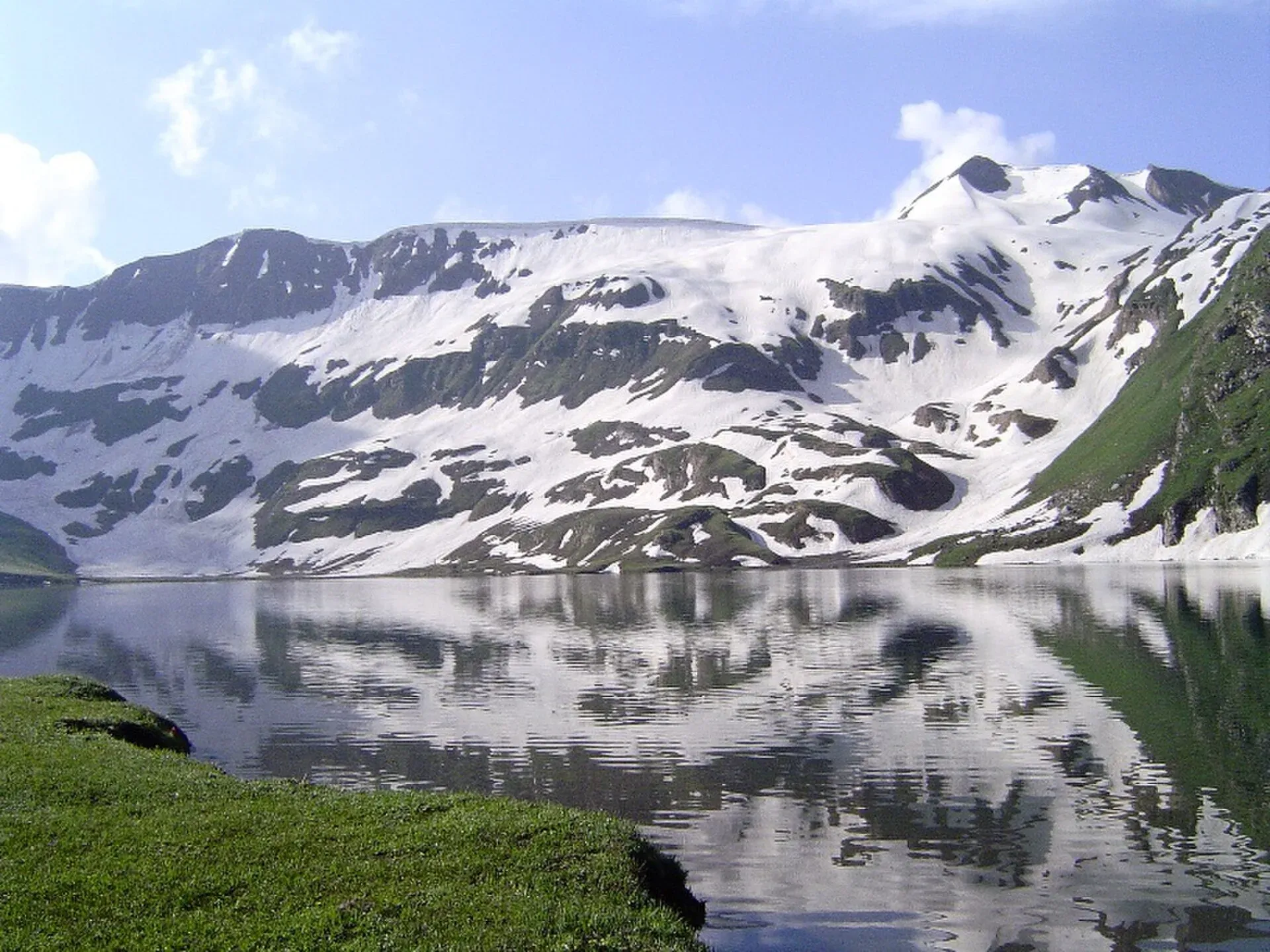
Photo: Chumer at English Wikipedia, with thanks · CC BY-SA 3.0 · via Wikimedia Commons · temporary stand-in photo

Dudipatsar Lake
An alpine lake at about 3,800 m in Lulusar-Dudipatsar National Park, reached by a 5 to 8 hour walk from Besal on the Babusar road. Mid-June to late September.
Overview
Dudipatsar Lake (also Dudipat) lies at about 3,800 m in Lulusar-Dudipatsar National Park, at the northern end of the Kaghan Valley in Mansehra District. It is about 835 m long and 600 m wide, and shallow, at around 5 m deep. Wikipedia describes the water as a greenish blue and very cold. Snow peaks surround it, averaging about 4,800 m, with snow patches in the shaded hollows, and in summer the water reflects them like a mirror. Glacier water feeds it, and the outflow runs down the Purbinar valley (the Poorbi Narr stream, a tributary of the Kunhar River).
The park sits in the western Himalayan alpine shrub and meadows ecoregion. Together with the neighbouring Saiful Muluk National Park, it protects about 88,000 hectares. The wetlands matter for resident wildlife and for migrating waterfowl. The park's fauna includes snow leopard, black bear, marmot, weasel, lynx, leopard, Himalayan snowcock and snow partridge (Wikipedia).
Plan your visit
- Nearest town
- Naran
- Getting there
Drive from Naran up the Babusar road to Besal (about 1 to 2 hours; hire a 4x4 in Naran, as the road can be damaged by rockfall). From Besal walk about 18 km (5 to 8 hours) to the lake. Mules can be hired at Besal. More
Best months
Jun – Sep
How to reach it
The trail starts at Besal (also spelled Besar), a village on the Babusar road just before Lulusar Lake, at about 3,250 m. Besal is roughly one hour's drive from Naran; some sources say two hours by jeep. At Besal there is a police check post, a drivers' hotel and space to camp. Parking is at your own risk, but someone can be hired to watch a vehicle for a day or two.
The track follows the Poorbi Narr stream up from Besal. The trail article gives 18 km, and the lake article says Besal is 15 km from the lake; neither cites a source. The total climb is about 640 m, which is modest, but it is harder at altitude. The trail article rates it medium difficulty. On the way you meet boulders, meadows, a plateau, streams and, early in summer, snow in the ravine. Streams are crossed on log bridges and one buggy bridge, and the plateau is marshy in places. The route passes through several life zones, from forest to alpine meadows. Herders use the trail and the slopes around it for summer pasture.
The trail article describes three ways to do it:
- One day. For moderate to experienced hikers: about 3 to 5 hours up and 3 to 4 hours down. The lake article says a fit person can do the track in 6 to 8 hours including breaks.
- Two days. For novice to moderate hikers: 6 to 10 hours up, with a night at Mulla ki Basti (2 km short of the lake) or at the lake, and 5 to 6 hours back.
- Three days. Two nights at Mulla ki Basti or the lake, with a full day to see the lake.
What to see and do
- Mulla ki Basti. A stone-hut village on the way, where most walkers stop overnight. The lake article advises making it your base and going on to the lake in the morning.
- The lake itself and views of the peaks around it.
- The outflow stream, a clear, shallow channel that leaves the lake and becomes the Poorbi Narr.
- Camping. Carry tents and sleeping bags.
- Birdwatching and wildlife on the wetlands. Hikers report marmots on the climb to the plateau.
When to visit
Mid-June to late September, when the track is clear. Early in the season there may be snow in the ravine below the plateau. In mid-September herders and the people of Mulla ki Basti come down for winter and the makeshift hotels close. After that, no lodging or food is available for 9 to 10 km from the start, so you need your own food and tents. The abandoned stone houses at Mulla ki Basti can give shelter for a night.
Where to stay and eat
Stay in Naran before and after. At Besal there is basic lodging and camping space. On the trail, simple huts sell tea in season. Mules can be rented at Besal to carry luggage.
Good to know
- Guide: experienced hikers can follow the stream without a guide, as the lake is at the head of the water, but a local guide is helpful. Guides are available at Besal.
- Fees: national park, guide and mule rates are not confirmed here. Current fees will be added soon. Ask at Besal.
- Footwear: waterproof boots, as the plateau is marshy.
- Altitude: the lake is above 3,500 m. Take it slowly.
- Weather: rain and cold at any time.
- Access: the 2005 earthquake made access harder; Wikipedia says the government has worked since 2006 to restore tourism facilities in the Kaghan Valley. See the Dudipatsar trek page too.
Highlights
- About 3,800 m in a national park
- Mirror-like reflections in summer
- Overnight at Mulla ki Basti
- Trailhead at Besal near Lulusar Lake
Getting there
Drive from Naran up the Babusar road to Besal (about 1 to 2 hours; hire a 4x4 in Naran, as the road can be damaged by rockfall). From Besal walk about 18 km (5 to 8 hours) to the lake. Mules can be hired at Besal.
Tips
- Rent a mule at Besal if carrying camping gear.
- Wear waterproof boots.
- Leave Besal early and expect a long day.
- Carry food after mid-September.
Photos we still need: Mulla ki Basti. Send us yours
Sources and last checked
Last checked Confidence medium4 sources3 still to check
- Last checked
- Method
- Desk research from published sources
- Confidence
- medium
- Checked by
- trek.pk research team
Researched from published sources; not yet checked on the ground by our team. Spot something out of date? Report a mistake.
Sources
- Dudipatsar Lake · Wikipedia · checked
- Dudipatsar Trail · Wikipedia · checked
- Lulusar-Dudipatsar National Park · Wikipedia · checked
- Pakistan Tourism Guide 2021 · TDAP (Trade Development Authority of Pakistan) · checked
Still to be checked on the ground (3)
- Altitude: 3,800 m (Wikipedia lake infobox, uncited); the trail article gives 3,900 m for the ridge and no figure for the lake itself
- Fees for park, guide and mules (none found in any source opened)
- Trail length: 18 km (trail article) or 15 km (lake article); both unsourced, so still open
Nearby and related

Dudipatsar Lake Trek from Besal

Lulusar Lake
A large lake beside the Naran-Babusar road in upper Kaghan, at roughly 3,350–3,410 m. It is the main source of the Kunhar River and the gateway to Lulusar-Dudipatsar National Park.

Saiful Muluk
The best-known lake of the Kaghan Valley, at 3,224 m above Naran, with Malika Parbat behind it. It is about 9 km from Naran, reached by jeep, and is snowbound and frozen in winter.

Ansoo Lake
A tear-shaped lake at about 4,126 m below Malika Parbat, reached on a steep, long day or overnight hike from Saiful Muluk. A hard walk, often with snow.