

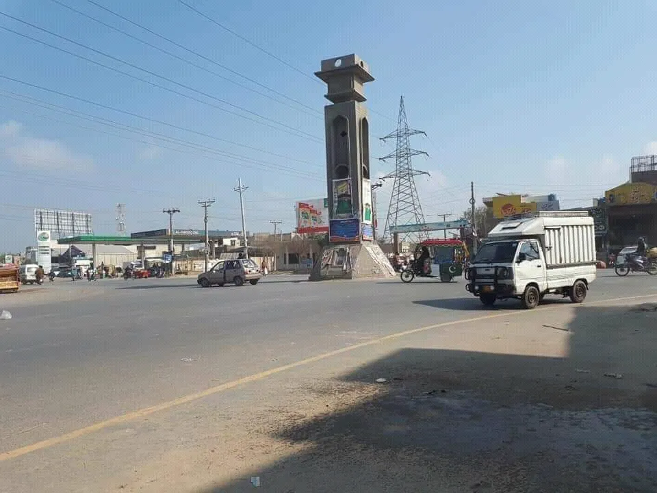
Photo: Zulkaif riaz kaif, with thanks · CC BY-SA 4.0 · via Wikimedia Commons · temporary stand-in photo

Hasilpur
Town in Bahawalpur District between the Sutlej and the Indian border, settled in 1752.
Overview
Hasilpur is a city in Hasilpur Tehsil, Bahawalpur District, Punjab. It lies between the Sutlej River and the Indian border, 96 km east of Bahawalpur. It was settled in 1752 and became a municipal committee in 1976.
Plan your visit
- Getting there
From Bahawalpur: 96 km east (Wikipedia). Rail and bus links are not verified. More
Best months
Oct – Mar
- Hasilpur
- Related place nearby: Bahawalnagar
Growth and people
Hasilpur has grown fast. Census counts rose from 3,490 in 1951 to 37,026 in 1981, 71,295 in 1998, 115,536 in 2017 and 168,146 in 2023, which ranks it 66th in Pakistan. In 2023 the municipal committee area was about 70 per cent Punjabi-speaking and 22 per cent Saraiki-speaking, with 7 per cent speaking Urdu.
What to see and do
No sights are named in the sources found; the only landmark shown is Missile Chowk, a traffic roundabout. Most visitors pass through on the way to Bahawalnagar or Bahawalpur. See also the Sutlej River. Wikipedia lists nearby towns including Mailsi, Vehari, Bahawalnagar, Chishtian, Haroonabad and Khairpur Tamewali.
When to visit
October to March. Summers are very hot.
Where to stay and eat
No verified hotels or restaurants. Bigger cities nearby have more choice.
Good to know
- No verified details on banks, pharmacies, fuel or transport; check on arrival.
- Safety. The UK FCDO Pakistan page (updated 27 October 2026, checked 17 November 2026) advises against all but essential travel within 5 miles of the India border and, in Punjab, to Dera Ghazi Khan only. Hasilpur lies between the Sutlej and the Indian border, so part of it may be within the 5-mile border area. It is not named on the page, so check the live page before you go.
Highlights
- Settled in 1752
- 96 km east of Bahawalpur
Getting there
From Bahawalpur: 96 km east (Wikipedia). Rail and bus links are not verified.
Hotels, food, fuel and services in Hasilpur
Places to stay
- Decent Girls HostelCall Decent Girls HostelMap of Decent Girls Hostel in Google Maps
Places to eat
- Baba Mehnga RestaurantMap of Baba Mehnga Restaurant in Google Maps
- Arfat BakersCall Arfat BakersMap of Arfat Bakers in Google Maps
- BITES BAKERSCall BITES BAKERSMap of BITES BAKERS in Google Maps
- Tehzeeb super storeCall Tehzeeb super storeMap of Tehzeeb super store in Google Maps
- YADGAR RESTAURANT HASILPURCall YADGAR RESTAURANT HASILPURMap of YADGAR RESTAURANT HASILPUR in Google Maps
- Shamsheer Sweets and BakersCall Shamsheer Sweets and BakersMap of Shamsheer Sweets and Bakers in Google Maps
Essential services fuel stations, mechanics, ATMs, pharmacies and hospitals and clinics
Fuel
- Ramay Filling StationCall Ramay Filling StationMap of Ramay Filling Station in Google Maps
- Jinnah Petroleum ServiceCall Jinnah Petroleum ServiceMap of Jinnah Petroleum Service in Google Maps
- ShellCall ShellMap of Shell in Google Maps
- ShellCall ShellMap of Shell in Google Maps
- GO Petrol PumpCall GO Petrol PumpMap of GO Petrol Pump in Google Maps
- Hayat Petrolium ( HORIZON )Call Hayat Petrolium ( HORIZON )Map of Hayat Petrolium ( HORIZON ) in Google Maps
Mechanics and tyre shops
- Tahir Tyre HouseCall Tahir Tyre HouseMap of Tahir Tyre House in Google Maps
- Mahar Khalil marketCall Mahar Khalil marketMap of Mahar Khalil market in Google Maps
- Choudhary Aslam Autos HasilpurCall Choudhary Aslam Autos HasilpurMap of Choudhary Aslam Autos Hasilpur in Google Maps
- Bismillah Motor WorkshopCall Bismillah Motor WorkshopMap of Bismillah Motor Workshop in Google Maps
ATMs
- Allied Bank Limited ATMCall Allied Bank Limited ATMMap of Allied Bank Limited ATM in Google Maps
- HBL ATMMap of HBL ATM in Google Maps
- FINCA Microfinance Bank HasilpurCall FINCA Microfinance Bank HasilpurMap of FINCA Microfinance Bank Hasilpur in Google Maps
Pharmacies
- Fatima PharmacyCall Fatima PharmacyMap of Fatima Pharmacy in Google Maps
- Millat pharmacyCall Millat pharmacyMap of Millat pharmacy in Google Maps
- PocketpharmaCall PocketpharmaMap of Pocketpharma in Google Maps
- Mubashar PharmacyCall Mubashar PharmacyMap of Mubashar Pharmacy in Google Maps
- Saif PharmacyMap of Saif Pharmacy in Google Maps
- New Madina Medical StoreCall New Madina Medical StoreMap of New Madina Medical Store in Google Maps
Hospitals and clinics
- Ramay HospitalCall Ramay HospitalMap of Ramay Hospital in Google Maps
- Abdullah Orthopedic and Urinary HospitalCall Abdullah Orthopedic and Urinary HospitalMap of Abdullah Orthopedic and Urinary Hospital in Google Maps
- THQ Hospital HasilpurMap of THQ Hospital Hasilpur in Google Maps
- New Punjab Homeopathic Clinic & Store HasilpurCall New Punjab Homeopathic Clinic & Store HasilpurMap of New Punjab Homeopathic Clinic & Store Hasilpur in Google Maps
- RAFI MEDICAL COMPLEXCall RAFI MEDICAL COMPLEXMap of RAFI MEDICAL COMPLEX in Google Maps
- Dr.Abid HospitalCall Dr.Abid HospitalMap of Dr.Abid Hospital in Google Maps
Listings come from Google Maps data and are unverified: phone numbers, opening months and prices may have changed. Report a problem · Own one of these? Claim it
Tips
- Check the FCDO page for the India border area.
Photos we still need: a bazaar street or the Sutlej bank near Hasilpur. Send us yours
Sources and last checked
Last checked Confidence low2 sources3 still to check
- Last checked
- Method
- Desk research from published sources
- Confidence
- low
- Checked by
- trek.pk research team
Researched from published sources; not yet checked on the ground by our team. Spot something out of date? Report a mistake.
Sources
- Hasilpur · Wikipedia · checked
- Pakistan travel advice: warnings and insurance · UK FCDO (GOV.UK) · checked
Still to be checked on the ground (3)
- Sights
- Transport links
- Hotels and services
Nearby and related

Bahawalpur
Former capital of a princely state on the edge of the Cholistan Desert: Nawabi palaces, a museum, desert crafts, and a base for Lal Suhanra, Derawar Fort and Uch Sharif.
Bahawalnagar
District capital in the south-east of Punjab, near the Cholistan desert and the Fort Abbas area, renamed in 1904.

Sutlej River
The longest of Punjab's five rivers, about 1,450 km from Lake Rakshastal in Tibet. It enters Pakistan east of Kasur, passes Sulemanki and Islam headworks, and meets the Chenab north of Uch Sharif to form the Panjnad.