

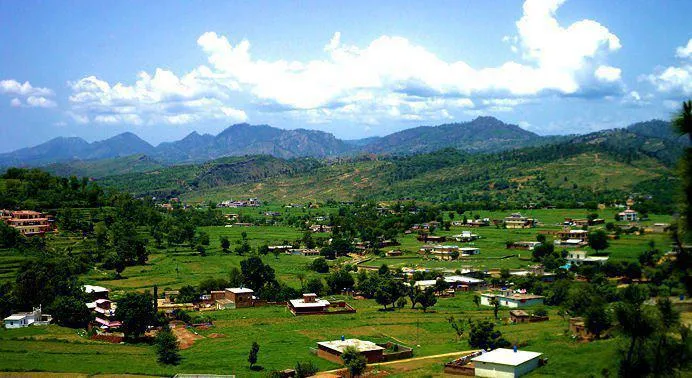
Photo: Kashmirians, with thanks · CC BY-SA 3.0 · via Wikimedia Commons · temporary stand-in photo

Samahni Valley
A forested hill valley in Samahni tehsil, about 17 km north of Bhimber in Azad Kashmir, along the Line of Control. FCDO advises against travel within 10 miles of the Line.
Overview
Samahni is a tehsil of Bhimber District in Azad Kashmir, in the south of the district along the Line of Control with India. It is about 17 km north of Bhimber. Its forested hills and valleys are collectively known as the Samahni Valley. The tehsil covers 456 sq km and had 121,946 people in 18,137 households at the 2017 census, about 267 people per sq km. The local government area covers 47 villages.
A tourism site describes a green valley with pine-covered slopes, farmland, streams and seasonal waterfalls, best in March to April and October to November. This is a single commercial source.
Plan your visit
- Nearest town
- Bhimber
- Getting there
About 17 km north of Bhimber by road. Details from Mirpur and Islamabad are not confirmed. More
Best months
Mar – Apr, Oct – Nov
- Samahni Valley
- Related places nearby: Baghsar Fort, Bandala Valley, Kas Chanatar, Bhimber
Getting there
Samahni is about 17 km by road from Bhimber. Details of the road from Mirpur or Islamabad are not confirmed.
Sights and activities
The valley is reached as an extension from Bhimber. Baghsar Fort, an Indo-Islamic fort with an outer wall of 38 rooms and an inner darbar hall, lies in the same area; parts of it are closed because of the border. The main town of the tehsil is Samahni, and Jandala is named in a 2010 photograph.
Safety and practical points
- Security advice. The area is close to the Line of Control. The UK Foreign Office advises against all travel to within 10 miles of the Line of Control and against all but essential travel to Azad Jammu and Kashmir (checked 17 November 2026). Samahni lies along the Line of Control, so foreign visitors should not plan a trip there on the basis of this page.
- Past incidents. Dawn and Express Tribune have reported cross-border firing in the tehsil, including January 2018, when ten schoolgirls were wounded.
- Infrastructure. A wooden footbridge from the late 1980s, already in poor condition, collapsed in December 2024 and injured six schoolgirls. Locals petitioned for its rebuilding. Treat local bridges with care.
- Power. A 132/11 kV grid station opened in May 2026, the first in the tehsil; residents had previously received less than 90 V.
Highlights
- Forested hills in Bhimber District
- About 17 km north of Bhimber
- Near Baghsar Fort
Tips
- Samahni lies along the Line of Control; follow official advice.
- Allow a full day from Bhimber.
Sources and last checked
Last checked Confidence low4 sources4 still to check
- Last checked
- Method
- Desk research from published sources
- Confidence
- low
- Checked by
- trek.pk research team
Researched from published sources; not yet checked on the ground by our team. Spot something out of date? Report a mistake.
Sources
- Samahni Valley (Wikipedia) · Wikipedia · checked
- Samahni Valley: Best Time to Visit · Green Tourism Pakistan · checked
- 6 students injured as wooden bridge collapses in AJK's Samahni Town · Dawn · checked
- Pakistan travel advice (last updated 27 October 2026) · UK FCDO · checked
Still to be checked on the ground (4)
- Road details from Mirpur and Islamabad
- Current access rules near the Line of Control
- Best months (one commercial source)
- Coordinates are for Samahni tehsil (Wikipedia); the tourism site gives a different point
Nearby and related
Baghsar Fort
A neglected Mughal-style fort in the Samahni valley, Bhimber district, right beside the Line of Control. Some parts are closed to visitors.

Azad Jammu and Kashmir
A green, hilly region in the Himalayan foothills: Muzaffarabad, the Neelum and Leepa valleys, lakes and waterfalls. Visit with local advice on permission and the Line of Control.
Bandala Valley
A narrow valley in Bhimber District, Azad Kashmir, running from the Tawi River to Samahni Valley. Its last villages are close to the Line of Control.
Kas Chanatar
A low foothill valley beside Bhimber city in Azad Kashmir, at about 390 m, with farming villages and a seasonal stream. Little visitor information.
Bhimber
A low-lying town and district headquarters in southern Azad Kashmir, historically the 'Door to Kashmir' on the Mughal route to Srinagar. UK advice is against all but essential travel to AJK.