

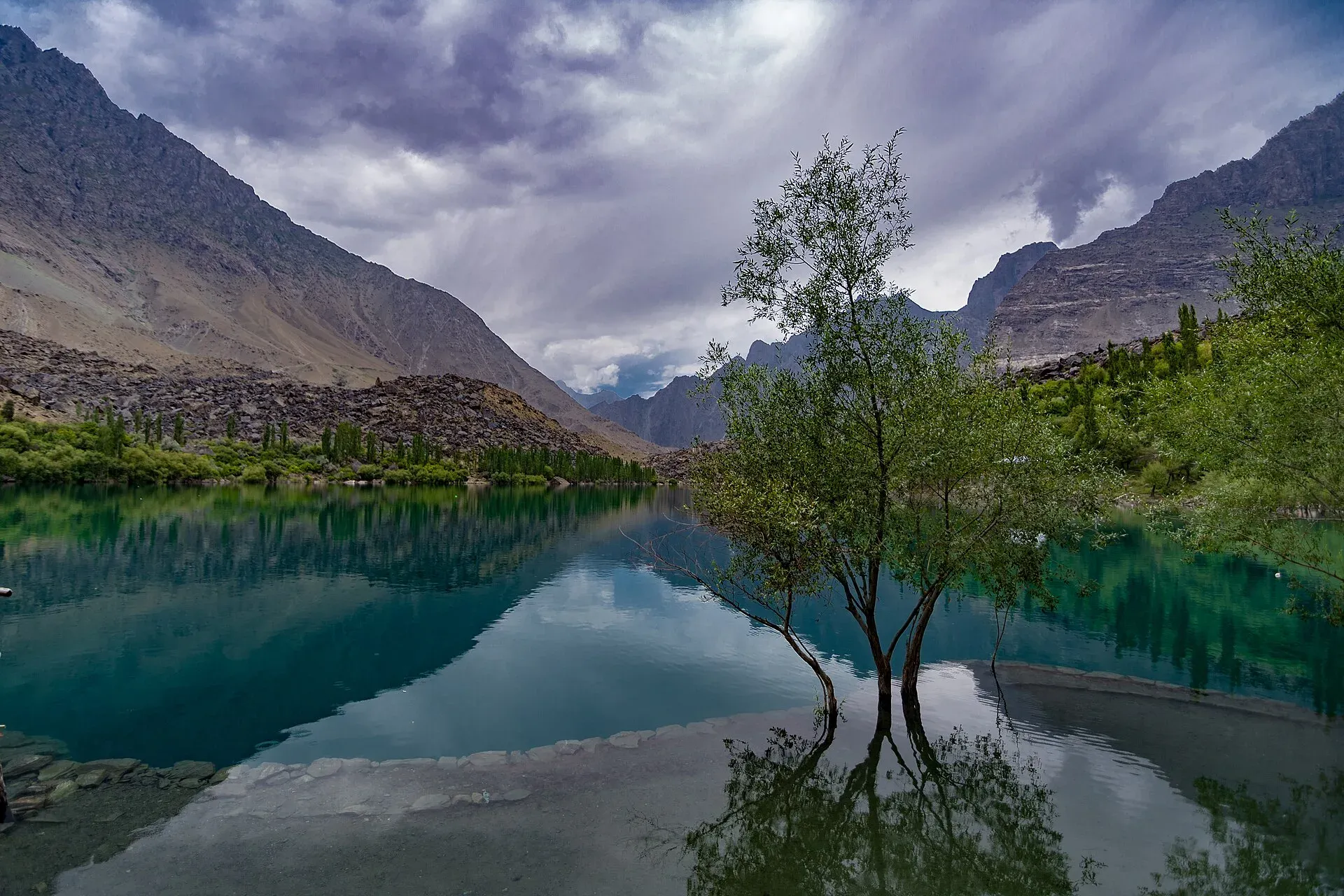
Photo: Syedusman, with thanks · CC BY-SA 4.0 · via Wikimedia Commons · temporary stand-in photo

Upper Kachura Lake
A clear lake about 70 m deep at around 2,500 m, near Shangrila, west of Skardu. Also called Foroq Tso, it freezes in winter. A short walk or drive from the road, it is popular for walks and trout fishing.
Overview
Upper Kachura Lake, known in Balti as Foroq Tso, is one of the three Kachura (Kachora Tso) lakes in Skardu District, together with Lower Kachura (Shangrila) and Zambakha Tso. All lie at about 2,500 m in the Indus basin. Upper Kachura is clear and about 70 m deep. In summer the water is around 15 degrees C, and in winter the surface freezes solid.
The lake sits in a bowl of rocky ridges above the Indus. It is quieter than Lower Kachura, with fewer buildings and more space for walking. Wikipedia places the Kachura lakes in the Western Himalayan subalpine conifer forest ecoregion and notes wild apricot orchards in the area. The same article calls the area little explored by travellers, because of rough ground and limited facilities.
Plan your visit
- Nearest town
- Skardu
- Getting there
The lake is about 31 km from Skardu by road (OSRM: 31.5 km, 27 minutes of driving without stops), west of Skardu, near Shangrila and Kachura village. Taxis and jeeps from Skardu take roughly 45 minutes. More
Best months
May – Oct
- Upper Kachura Lake
- Related places nearby: Lower Kachura Lake (Shangrila), Satpara Lake
What to see and do
- Walk around the shore. The lake and the village paths nearby make an easy morning.
- Trout fishing. The lake is known for trout. Wikivoyage (undated) says fishing permits come from the Fisheries Department in Skardu or Gilgit; ask locally about current rules.
- Photography. Calm mornings and autumn colour give the best reflections of the ridges.
- Combine with Lower Kachura Lake. The two lakes are close, and many people see both in one half-day.
- Alampi La and Banak La treks. The trek to Astore starts near Kachura Lake. See Other treks in Baltistan.
When to visit
May to October. Wikivoyage gives April to October as the Skardu season. It describes flowers along the banks in spring, peach, apricot and apple blossom in April, and apples ripening in summer, though it does not separate the upper and lower lakes. Summer is green and warm. Autumn is colourful in October. In winter the lake freezes and the road can be icy, though the area is reachable.
Where to stay and eat
Stay in Skardu or in guesthouses and resorts around Shangrila. Cafes and small stalls near the lake serve tea and snacks. Camping rules vary by landowner, so ask locally.
Good to know
- Getting there: about 31 km from Skardu by road (OSRM), near Shangrila. Allow about 45 minutes by car or taxi (Wikivoyage says about 32 km and an hour by jeep). The final stretch is a short walk or rough lane from the main road. Check locally.
- Fees: a fee may apply at some points. Current fees will be added soon.
- Safety: the water is cold and deep. Do not swim, and stay off thin winter ice.
- Respect: keep the shoreline clean and ask before photographing people.
Highlights
- Clear water about 70 m deep
- Freezes in winter; about 15 degrees C in summer
- Quieter than Lower Kachura
- Starting area for the Alampi La and Banak La treks
Getting there
The lake is about 31 km from Skardu by road (OSRM: 31.5 km, 27 minutes of driving without stops), west of Skardu, near Shangrila and Kachura village. Taxis and jeeps from Skardu take roughly 45 minutes. From the main road a short walk or rough lane leads to the lake. Check the final access locally.
Tips
- Combine with Lower Kachura Lake in the same trip.
- Go in the morning for calm water.
- Stay off the ice in winter and do not swim.
Photos we still need: Skardu bazaar or a meal near the lake (Where to stay and eat). Send us yours
Sources and last checked
Last checked Confidence medium6 sources4 still to check
- Last checked
- Method
- Desk research from published sources
- Confidence
- medium
- Checked by
- trek.pk research team
Researched from published sources; not yet checked on the ground by our team. Spot something out of date? Report a mistake.
Sources
- Kachura Lake · Wikipedia · checked
- Other treks in Baltistan (Alampi La and Banak La) · trek.pk / Lonely Planet · checked
- Pakistan Tourism Guide 2021 · TDAP (Trade Development Authority of Pakistan) · checked
- OSRM driving route service: road distances and times measured 16 November 2026 (driving only, optimistic on mountain roads) · OSRM / OpenStreetMap contributors · checked
- Skardu · Wikivoyage · checked
- Upper Kachura Lake · Wikipedia · checked
Still to be checked on the ground (4)
- Fees, if any (no entry fee listed in Wikivoyage or Wikipedia; none confirmed)
- Camping rules (no source found); fishing permit rules (Fisheries Department per Wikivoyage, undated)
- Walk from the road to the lake (no source gives distance or time)
- Altitude: Wikipedia gives about 2,500 m for the Kachura lakes together; no per-lake figure found
Nearby and related

Other treks in Baltistan

Lower Kachura Lake (Shangrila)
Also called Shangrila Lake, a lake at about 2,500 m near Skardu inside a resort that has operated since 1983. Boating, gardens and an aircraft-fuselage restaurant.

Satpara Lake
A large lake at about 2,600 m, a short drive south of Skardu. It supplies Skardu's water and fed the Satpara Dam. Trout, a small island and the road to Deosai make it an easy half-day outing.