

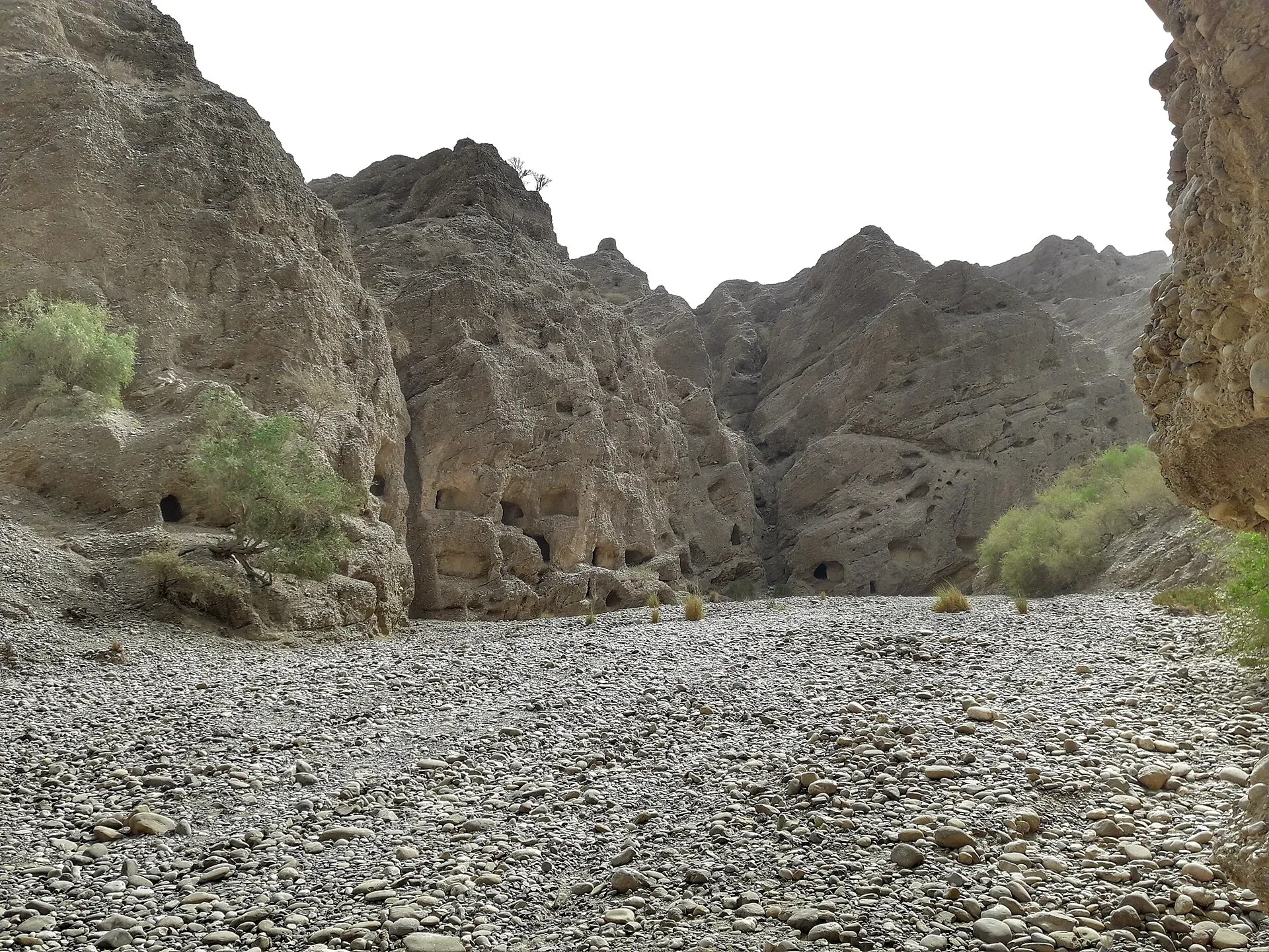
Photo: SALMAN SHAIKH, with thanks · CC BY-SA 4.0 · via Wikimedia Commons · temporary stand-in photo

Bela
A town in Lasbela District, Balochistan, on the Karachi to Quetta road at about 88 m. It is ancient Armabil, with caves nearby at Gondrani, but official advice is against all travel in Balochistan.
Overview
Bela is the headquarters of Bela tehsil in Lasbela District, Balochistan, an ancient city surrounded by hills above the Arabian Sea, at about 88 m. It lies about 180 km north-west of Karachi and about 500 km south of Quetta, on the N-25 highway. Wikipedia gives 29,380 people at the 2023 census, up from 24,603 in 2017. Balochi is the first language of about 85% of residents. Lasi, a Sindhi dialect, Pashto and Brahui are also spoken. The town is mostly Muslim, with a small Sindhi Hindu community.
Plan your visit
- Getting there
Road: about 179 km from Karachi, around 2 hours 10 minutes by OSRM (checked 16 November 2026), on the N-25. Quetta is about 500 km north (Wikipedia). More
Best months
Nov – Mar
- Bela
- Related place nearby: Gondrani Caves
History
In autumn 325 BC the town figures in Alexander the Great's campaign under the name Rhambacia, where, Wikipedia says, he left Hephaestion behind to build it. Alexander's historians called the river here the Arabius (now the Hub River) and the local people Oreitans. In 711 AD it appears as Armabil in the campaign of Muhammad bin Qasim. Arab sources and the Chachnama give variants such as Armael and Armapilla. It was described as the second port city of Sindh after Debal.
The tomb of Muhammad ibn Haroon, a general in Muhammad bin Qasim's campaign, is in Bela.
Gondrani caves
Gondrani, also called Shehr-e-Roghan and locally "Puraney Ghaar" (old house), is a rock-cut settlement near Bela. Wikipedia places it about 20 km north of Bela and about 218 km from Karachi, but its sources disagree on the exact position (about 15 to 18 km north-west in two of them). See also Gondrani caves.
The caves are cut into solid conglomerate rock on several levels, joined by pathways. Each has a small room with a hearth, niches in the wall for lamps and a verandah. About 1,500 caves were reported in British times, and about 500 remain. The builders are unknown. Some historians describe it as a large Buddhist monastery of the eighth century. Scholars differ on how clearly Buddhist it is, and the sources cited range from "undoubtedly Buddhist" to "definite Buddhist characteristics" without being irrefutable.
Local legend tells of demons that tormented the townspeople, and of an old holy woman, Mai Gondrani, who sacrificed herself or drove them out. Her grave nearby is a well-known local shrine. The caves are eroding, and no conservation work is recorded. Access is by track.
What to see and do
- Gondrani caves, described above. Ask locally before travelling.
- Tomb of Muhammad ibn Haroon, in the town.
- Town and bazaar. A working market town.
- Further afield. The coast and Hingol area are further south and west; see Hingol National Park.
Kundi, about 64 km north of Bela, has copper, lead and silver traces, and manganese ore is found in the ophiolite belt around Bela. These are mining sites, not visitor sights.
When to visit
November to March is cooler. Summers are very hot.
Where to stay and eat
There are few places to stay, and most travellers use Karachi or other bigger towns. Food is simple local fare.
Good to know
- No fuel, ATM or clinic details for Bela are documented.
- Dress modestly and ask before photographing people.
Ask the district administration or local police about current conditions before you go. Travel advice: For foreign visitors: the UK FCDO advises against all travel to Balochistan Province (advice updated 27 October 2026, checked 16 November 2026). Bela is in Balochistan, so this applies. Read the live advice before you plan.
Highlights
- Ancient Armabil and Alexander-era history
- Gondrani cave city nearby
- On the N-25 Karachi to Quetta highway
Getting there
Road: about 179 km from Karachi, around 2 hours 10 minutes by OSRM (checked 16 November 2026), on the N-25. Quetta is about 500 km north (Wikipedia).
Stay, eat and essentials near Bela
Within 8 km of Bela, nearest first.
Essential services fuel stations, ATMs, banks, pharmacies and hospitals and clinics
Fuel
- RB Shop آر بی شاپCall RB Shop آر بی شاپMap of RB Shop آر بی شاپ in Google Maps
- Baloch Petroleum BelaCall Baloch Petroleum BelaMap of Baloch Petroleum Bela in Google Maps
ATMs
- NBP Bank BelaMap of NBP Bank Bela in Google Maps
Banks and money exchange
- United Bank LimitedMap of United Bank Limited in Google Maps
- Bank Al Habib Bela BranchMap of Bank Al Habib Bela Branch in Google Maps
Pharmacies
- Zahid veterinary storMap of Zahid veterinary stor in Google Maps
Hospitals and clinics
- Civil Hospital BelaCall Civil Hospital BelaMap of Civil Hospital Bela in Google Maps
Listings come from Google Maps data and are unverified: phone numbers, opening months and prices may have changed. Report a problem · Own one of these? Claim it
Tips
- Read the live UK FCDO advice first.
- Ask locally about Gondrani access.
- Carry cash and supplies from Karachi.
- Dress modestly.
Photos we still need: Bela town or the tomb of Muhammad ibn Haroon; the Hub River near Bela. Send us yours
Sources and last checked
Last checked Confidence low4 sources4 still to check
- Last checked
- Method
- Desk research from published sources
- Confidence
- low
- Checked by
- trek.pk research team
Researched from published sources; not yet checked on the ground by our team. Spot something out of date? Report a mistake.
Sources
- Bela, Pakistan · Wikipedia · checked
- Gondrani · Wikipedia · checked
- OSRM driving routes (road distances and times) · Project OSRM / OpenStreetMap · checked
- Pakistan travel advice · UK FCDO (GOV.UK) · checked
Still to be checked on the ground (4)
- Gondrani distance and access (Wikipedia: about 20 km per Government of Balochistan; other sources 15 to 18 km north-west; no road directions found)
- Current security situation
- Fuel, ATM and clinic availability
- Accommodation options
Nearby and related

Karachi
Pakistan's largest city and main port: colonial buildings, museums, beaches, busy bazaars and some of the country's best food.

Kund Malir
Remote Arabian Sea beach at the edge of Hingol National Park, about 236 km west of Karachi on the Makran Coastal Highway. Fuel and food are scarce. Balochistan is under UK FCDO 'all travel' advice.

Hingol National Park
Pakistan's largest national park, about 6,100 square kilometres along the Makran Coastal Highway: desert canyons, mud volcanoes, the Hingol River, the Princess of Hope rock and the Hinglaj Mata temple.

Sonmiani Beach
Quiet village beach on Sonmiani Bay, about 80 km north-west of Karachi, next to the Miani Hor mangrove lagoon. A former port, now a small fishing settlement and a turtle beach. Balochistan is under FCDO 'all travel' advice.

Quetta
Balochistan's high-valley capital, the Fruit Garden of Pakistan: bazaars, sajji, orchard valleys and the base for Hanna Lake and Ziarat.

Gondrani Caves
A cluster of hand-cut caves on a hillside north of Bela in Lasbela, Balochistan, often called the Cave City. Their origin is uncertain and they are eroding. For foreign visitors: the UK FCDO advises against all travel to Balochistan.