

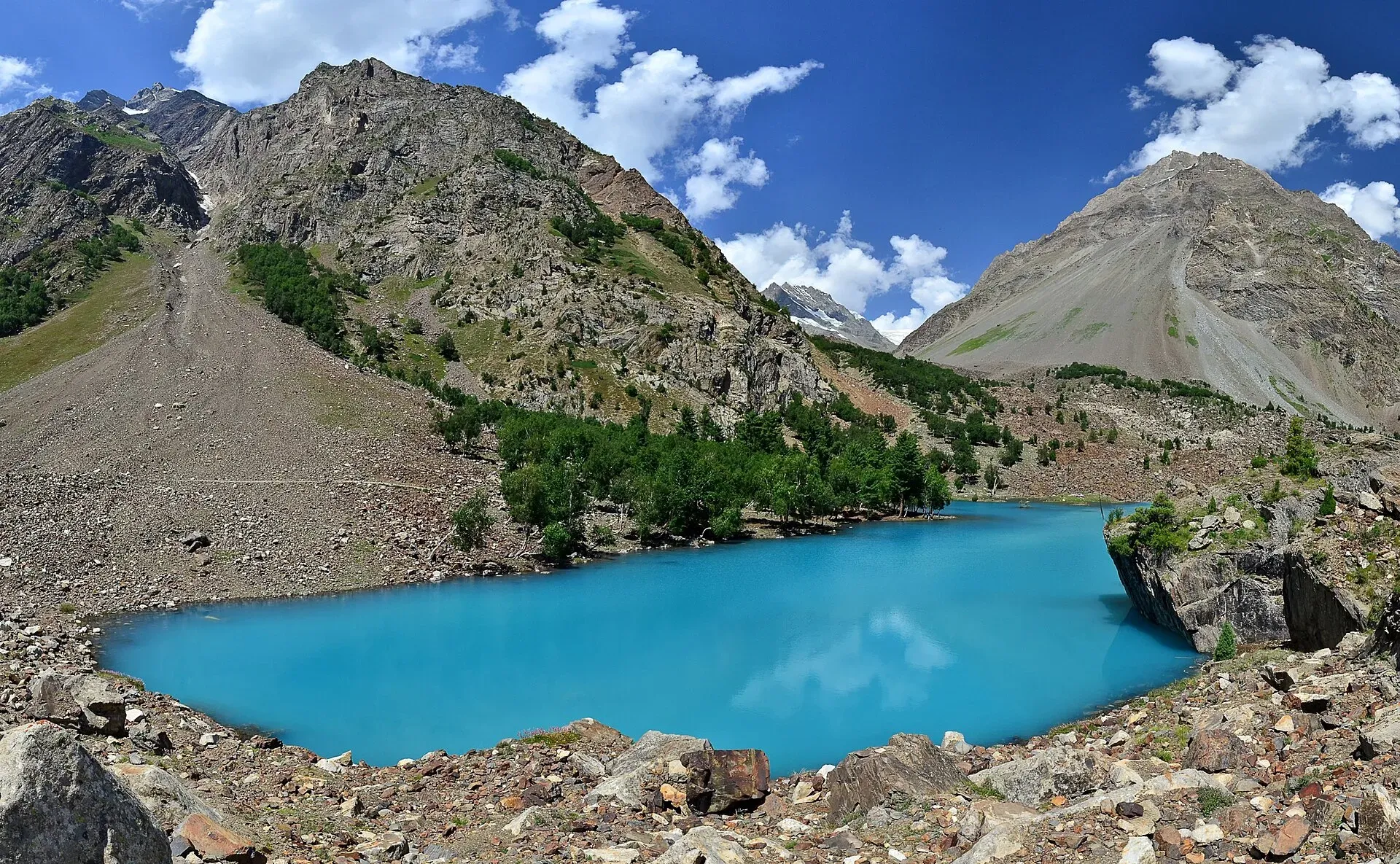
Photo: Thealimir, with thanks · CC BY-SA 3.0 · via Wikimedia Commons · temporary stand-in photo

Naltar Lakes
A group of three lakes at about 3,050 to 3,150 m above Naltar Valley near Gilgit. The Bashkiri lakes, including Satrangi and Blue Lake, are reached by a rough jeep road and are known for their colours.
Overview
The Naltar Lakes, also called the Bashkiri Lakes, lie at about 3,050 to 3,150 m in the upper Naltar Valley, around 34 to 40 km from Gilgit (Wikipedia gives 34 km to Naltar Bala and 40 km to Naltar Paain; the lakes are about 13 km beyond Naltar Bala). Pine forest surrounds them. The water is fed by the surrounding peaks and runs down the valley as a stream beside the road.
Plan your visit
- Nearest town
- Gilgit
- Getting there
From Gilgit drive 25 km north-east to Nomal on the Hunza River, then up the Naltar Valley to Naltar Bala (about 34 to 40 km from Gilgit in total, by Wikipedia; the lakes are about 13 km further). More
Best months
May – Oct
The three lakes
Wikipedia and visitors name three main lakes:
- Bashkiri Lake I (Satrangi, "seven colours"): the largest and best known, with blue and green shades.
- Bashkiri Lake II (Blue Lake): deep blue water.
- Bashkiri Lake III (Feroza, "azure"): a bright blue-green lake.
Wikipedia's valley article also lists Halima, Bodo, Dhudia and Pari among the lakes, and its introduction names a different set of three, so counts and names vary. Ask your driver which lake is which before you set out.
The Naltar Valley
Naltar is a side valley of the Hunza River. The road leaves the Karakoram Highway at Nomal, about 25 km from Gilgit, and climbs the valley past Naltar Paain (the lower settlement) to Naltar Bala (the upper). A paved road, the Naltar Expressway, links the valley with Gilgit via Nomal and Faizabad; beyond Naltar Bala the road to the lakes is unpaved and narrow.
The valley is also known for skiing. Naltar ski resort hosts ski competitions, and the slopes are in the foothills of the Naltar mountains. Muhammad Abbas, from the valley, was the first Pakistani Winter Olympian, at the 2010 Vancouver Games.
Naltar Wildlife Sanctuary was established on 22 November 1975. Wikipedia lists Astor markhor, Alpine ibex, snow leopard, brown bear, grey wolf and red fox, and about 35 bird species. Most are hard to see; ibex and marmots are the most likely sightings. Forest at higher levels is conifer, with spruce and juniper; lower down are birch, willow, poplar and ash.
How to reach them
From Gilgit, the road runs north-east to Nomal on the Hunza River, then up the Naltar Valley to Upper Naltar. The first lake is about 12 km further on a dirt road beside the stream. The final stretch needs a high-clearance 4x4 and an experienced driver. Some parties walk part of the way.
What to see and do
- The three lakes and the pine and larch forest around them.
- Naltar Valley with its meadows, and a small ski area used in winter.
- Treks. The Naltar lakes are on the first days of the Pakora Pass and Daintar Pass treks.
- Birds and wildlife. See the sanctuary notes above.
When to visit
May to October. In winter heavy snow makes the lakes almost impossible to reach by vehicle. Autumn colours (October) are popular with photographers.
Where to stay and eat
There are guesthouses and small hotels in Naltar village and simple camping near the lakes. Wikipedia lists government rest houses in the valley, the oldest being the public works department rest house, as well as private guesthouses and hotels. Meals are available in the village. Ask your host for current arrangements.
Good to know
- Fees: we have no confirmed official fee for the lakes. Jeep rates vary and are not set officially. Current fees will be added soon; ask in Gilgit.
- Road: rough and narrow. Ask locally about snow and landslides.
- Altitude: the lakes are above 3,000 m. Take it slowly.
- Weather: cold nights, even in summer.
- Respect: the valley has Shia and Sunni communities. Dress modestly and ask before photographing people.
Highlights
- Three lakes at about 3,050 to 3,150 m
- Satrangi, Blue and Feroza lakes
- Rough jeep road from Naltar village
- Start of the Pakora and Daintar pass treks
Getting there
From Gilgit drive 25 km north-east to Nomal on the Hunza River, then up the Naltar Valley to Naltar Bala (about 34 to 40 km from Gilgit in total, by Wikipedia; the lakes are about 13 km further). A rough jeep road leads about 12 km on to the first lake. A 4x4 and an experienced driver are needed. Winter snow usually blocks the road.
Tips
- Hire an experienced 4x4 driver in Gilgit or Nomal.
- Visit between May and October.
- Bring warm layers and sun protection.
Sources and last checked
Last checked Confidence medium3 sources5 still to check
- Last checked
- Method
- Desk research from published sources
- Confidence
- medium
- Checked by
- trek.pk research team
Researched from published sources; not yet checked on the ground by our team. Spot something out of date? Report a mistake.
Sources
- Naltar Lakes · Wikipedia · checked
- Naltar Valley · Wikipedia · checked
- Pakistan Tourism Guide 2021 · TDAP (Trade Development Authority of Pakistan) · checked
Still to be checked on the ground (5)
- Jeep road conditions this season
- Lake altitude: Wikipedia gives 3,050 to 3,150 m for the group, with the infobox figure marked citation needed; no per-lake heights
- Which of the three lakes each photo shows (photo titles on Commons give lake numbers inconsistently)
- Naltar village and ski slopes: Photo needed
- Lake coordinates (not taken from a source)
Nearby and related

Pakora Pass

Daintar Pass
Naltar Lakes Walk (Satrangi, Blue and Pari Lakes)
Nomal Valley
A green oasis on the Hunza River about 25 km north of Gilgit, and the turn-off for the Naltar road.

Gilgit
Gateway to Gilgit-Baltistan on the Karakoram Highway: a busy mountain town with the Kargah Buddha and the base for Hunza, Naltar and Skardu.