

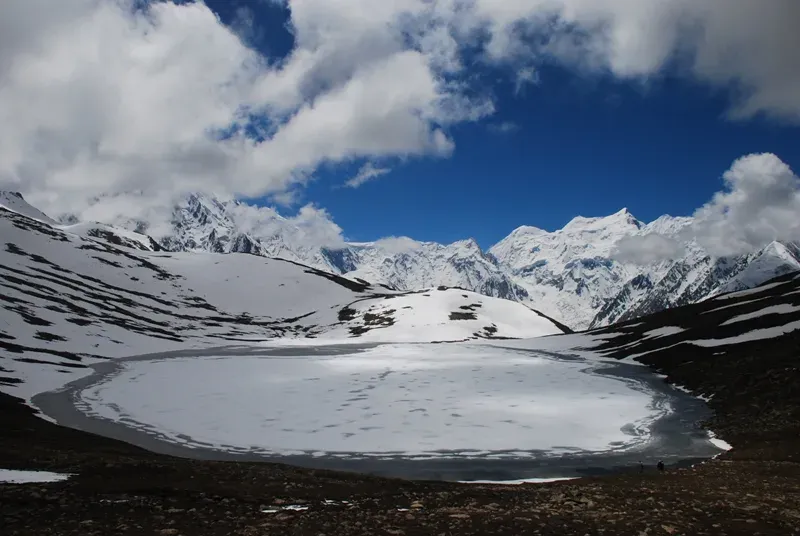
Photo: Rajaislam, with thanks · CC BY 3.0 · via Wikimedia Commons · temporary stand-in photo
Rush Lake
One of the highest lakes in Pakistan, at about 4,694 m, above the Hopar Valley in Nagar. It can only be reached on a hard five-day trek with views of the Hunza giants and, on clear days, K2.
Overview
Rush Lake, also called Rush Phari, lies at about 4,694 m on a ridge between the Hispar Valley and the Barpu Glacier in Nagar. Wikipedia ranks it among the highest alpine lakes in the world. It is a glacial lake, and its outflow runs to Miar Glacier. The lake is a destination for trekkers, not drivers: there is no road, and the walk takes several days.
The reason to go is the view. From the lake, and from the hilltop above it, you see Spantik, Malubiting, Miar Peak, Phuparash and Ultar Sar, and on a clear day K2 and Broad Peak far to the east. It lies about 15 km north of Miar Peak and Spantik (Golden Peak).
Plan your visit
- Nearest town
- Hopar
- Getting there
Drive to Hopar (Hoper) in Nagar, the road end: about 1.5 hours by special hire from Karimabad or Ganesh; More
Best months
Jun – Sep
How to reach it
The trailhead is Hopar (Hoper), at the road end in Nagar. Special-hire vehicles run from Karimabad or Ganesh in about 1.5 hours. From there the route goes up the Hopar (Bualtar) Glacier and Miar Glacier side, with the first day shared with the Barpu Glacier trek, then climbs steeply to the ridge and the lake. It rises about 1,500 m in two days. The full trek is described on the Rush Phari trek page.
The route in stages
- Hopar to Bericho Kor (about 3,300 m). Cross the Bualtar Glacier, take a lower trail east to the Barpu Glacier, then follow a dry ablation valley (the trough between a glacier and its side wall) past Barpugram and Mulharai to the grassy camp. A trickle of water crosses the site.
- Bericho Kor to Chidin Harai (about 4,440 m). The steepest day, hot and dry with no water until camp. The trail climbs a ridge through artemisia (a grey-leaved shrub), thyme and juniper to a cairn at about 4,020 m, then follows a grassy ridge to a pasture with a goat pen and huts. Water is five minutes above the huts. Across the valley are the peaks of the Hispar Muztagh, including Lupgar Sar, Momhil Sar and Trivor.
- Chidin Harai to the lake. A short day: climb a rocky slope, reach an overlook of the Barpu Glacier after about an hour, cross talus (loose rock) and arrive in about half an hour more.
- Descent to Phahi Phari (3,450 m). Very steep, through a gully, juniper, grass and artemisia steppe. Phahi Phari has reliable water and shade. The last day returns to Hopar by the Barpu trail in reverse.
What to see and do
- The lake itself. Turquoise water in a bare, windy setting. Stone shelters stand on the west shore, and the south-west shore is less windy for camping.
- Rush Peak. A flower-covered slope from the south shore leads to a hilltop at about 4,938 m and the summit of Rush Peak at about 5,098 m (the trek guidebook figure; Wikipedia gives the same height but its only reference is a dead link, and one operator quotes about 5,200 m). It is described as an easy scramble. Allow about four hours return from the lake.
- Hopar Valley. Spend a day or two in Hopar's villages to acclimatise before you climb.
When to visit
Mid-June to September. The lake is frozen or snowed in outside these months. Even in summer it is cold and windy at night.
Where to stay and eat
There is no accommodation at the lake. Camp, with all food carried in. Guesthouses are available in Hopar and Karimabad for the nights before and after.
Good to know
- Altitude: the rise is fast. Spend a few days above 3,000 m first, rest at Hopar or Bericho Kor, and go down if you feel unwell. Rescue is slow: the lake is about two days from the road.
- Guide: take a local guide. The descent to Phahi Phari is not obvious. Porters need warm bedding and shelter.
- Permits: Dawn reported on 29 March 2026 that foreign visitors to open-zone areas do not need a trekking permit, while permits from the Gilgit-Baltistan tourism department are needed for treks and climbs in restricted zones. There is no confirmed fee or camping rule for this route. Check with the Gilgit-Baltistan Tourism Department or a local operator before you go. Last checked 16 November 2026.
- Water: reliable water is at Phahi Phari and at the lake, with a spring near Chidin Harai.
Highlights
- Among Pakistan's highest lakes, about 4,694 m
- Views of Spantik, Malubiting, Miar Peak and Ultar Sar
- K2 and Broad Peak visible in clear weather
- Side trip to Rush Peak (about 5,098 m)
Getting there
Drive to Hopar (Hoper) in Nagar, the road end: about 1.5 hours by special hire from Karimabad or Ganesh; OSRM measures the Hopar glacier area about 25 km from Karimabad (34 minutes of driving without stops, so the 1.5 hours is allowing for the rough road). Hopar is a few hours from Gilgit on the Karakoram Highway and the Nagar road. From Hopar there is no road: the lake is a five-day round-trip trek via Bericho Kor (see the Rush Phari trek).
Tips
- Acclimatise first; the climb is steep and fast.
- Take a guide and give porters warm bedding.
- Leave spare days for weather.
- Do not wait out bad weather at the lake: descend.
Photos we still need: Chidin Harai pasture and the Hispar Muztagh view; the descent to Phahi Phari. Send us yours
Sources and last checked
Last checked Confidence medium5 sources4 still to check
- Last checked
- Method
- Desk research from published sources
- Confidence
- medium
- Checked by
- trek.pk research team
Researched from published sources; not yet checked on the ground by our team. Spot something out of date? Report a mistake.
Sources
- Rush Lake (Pakistan) · Wikipedia · checked
- Gilgit-Baltistan tourism bounces back despite Middle East war (permit rules, 29 March 2026) · Dawn · checked
- Trekking in the Karakoram and Hindukush (route facts, ~2002) · Lonely Planet · checked
- OSRM driving route service: road distances and times measured 16 November 2026 (driving only, optimistic on mountain roads) · OSRM / OpenStreetMap contributors · checked
- Rush Peak (Wikipedia) · Wikipedia · checked
Still to be checked on the ground (4)
- Altitude: Wikipedia's Rush Lake article gives 4,694 m (15,400 ft); some operators quote slightly different figures
- Current permit and NOC rules for foreigners
- Hero photo is only 800 px wide
- Rush Peak height: Wikipedia gives 5,098 m, citing only a dead link; other sources up to about 5,200 m


