

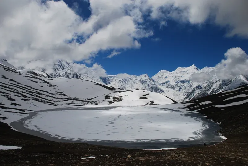
Photo: Rajaislam, with thanks · CC BY 3.0 · via Wikimedia Commons · temporary stand-in photo
Rush Phari (Rush Lake)
- Duration
- 5–7 days
- Distance
- 36.3 km
- Grade
- Strenuous
- Max altitude
- 4,694 m
- Season
- Jun – Sep
A hard 5-day trek from Hoper to Rush Lake (about 4,694 m), with 360-degree views of the Hunza giants and distant K2. Fast height gain: acclimatise first and take a guide.
Overview
Rush Phari, better known as Rush Lake, is a turquoise lake at about 4,694 m on a ridge between the Hispar Valley and the Barpu Glacier in Nagar. The reason to come is the view. From the lake and the hilltop above it you can see most of the Hunza giants, and on a clear day K2 (8,611 m), Broad Peak and Gasherbrum IV stand far to the east.
The trek goes from Hoper, shares its first stages with the Barpu Glacier trek, then climbs 1,500 m in two days. Wikipedia and several operators give the lake's height as 4,694 m. Some tour sites say 4,690 m or higher, and the figure should be treated as approximate.
Who it suits
Fit trekkers who have already spent a few days above 3,000 m. The rise is fast and there are no alternative camp sites near the lake without water, so retreat is only down. The trail is steep, hot and dry on day 2. This is a hard trek, not a long one.
When to go
Mid-June to September. By June the water at Gutens has dried, so the Bericho Kor route is the one to take. The lake can be windy and cold even in summer, and porters need shelter and bedding.
The route
Day 1 is the same as on the Barpu Glacier trek: Hoper to Bericho Kor (about 3,300 m) over the Bualtar and Barpu glaciers.
Day 2 starts early. From Bericho Kor the trail goes east behind two big boulders and climbs a ridge through artemisia, thyme and juniper. A cairn at 4,020 m marks the ridge top, and the trail from Gutens joins here. Continue east-south-east to Chidin Harai (about 4,440 m), a pasture with a goat pen, huts and water five minutes above. It faces the Hispar Muztagh to the north-east: Lupgar Sar, Momhil Sar, Trivor, Mulungutti Sar and Destaghil Sar.
Day 3 is short. Climb the rocky slope above the water, reach the Barpu overlook after about an hour, cross talus south-east, and reach the lake in about half an hour. Stone shelters are on the west shore. The south-west shore is less windy for camping.
Rush Peak. From the south shore, a flower-covered slope leads to a hilltop at 4,938 m (tent platforms, no water), then to the summit of Rush Peak (5,098 m by the guidebook; some sources say about 5,200 m). It is an easy scramble. Allow about four hours return from the lake.
The descent on day 4 is very steep to Phahi Phari (3,450 m), and day 5 returns to Hoper. Two other routes reach the lake from Gutens, one from Barpugram and one from Huru in the Hispar Valley. Both are dry later in summer.
Terrain underfoot
Day 1 is the glacier day: the Bualtar Glacier, then a lower trail to the Barpu Glacier, then a dry ablation valley (the trough between a glacier and its side wall) to Bericho Kor. Day 2 is a dry, steep ridge of artemisia (a grey-leaved shrub), thyme and juniper. Day 3 crosses talus (loose rock fall) with a stream to keep right of. Day 4 drops down a very steep gully and artemisia steppe to Phahi Phari. Expect hot, dry slopes below 4,000 m and wind and cold at the lake.
Views from the lake
Wikipedia lists Spantik, Malubiting, Miar Peak, Phuparash Peak and Ultar Sar among the peaks seen on the trek, and puts the lake about 15 km north of Miar Peak and Spantik. Its outflow feeds the Miar Glacier. Wikipedia also ranks it, on the strength of one website, as the 27th highest lake in the world; treat that as approximate.
Culture and people
You walk through the five hamlets of Hoper. Hire porters through the village union. Porters need warm bedding and shelter at the lake. If you go by Gutens you will need people to carry water. Respect grazing areas and keep to the trail.
Practical information
- Guide: needed. The descent to Phahi Phari is not obvious.
- Map: the Swiss 1:250,000 sheet does not show the trails from Bericho Kor to the ridge or from the lake to Phahi Phari.
- Altitude: if you feel unwell at the lake, descend to Phahi Phari or Bericho Kor.
- Stages: the old route counts eight stages round trip from Hoper.
- Operators: tour operators sell this as a 7 to 16 day trip, which usually includes extra days at the start and end.
Planning notes
A rest day at Hoper or Bericho Kor before the climb helps a lot. If weather turns on day 3, do not wait it out at the lake: the descent is steep and easier in daylight. Share your plan with your hotel and guide.
Highlights
- Turquoise lake at about 4,694 m
- Panorama from Hispar Muztagh to distant K2
- Optional scramble up Rush Peak (about 5,098 m)
- Sunset at Chidin Harai
Day by day
| Day | Camp | Altitude |
|---|---|---|
| 1 | Bericho Kor | 3,300 m |
| 2 | Chidin Harai | 4,440 m |
| 3 | Rush Phari | 4,694 m |
| 4 | Phahi Phari | 3,450 m |
| 5 | Hoper | 2,790 m |
| Day | Route | Hours | Distance | Ascent / descent | Camp and altitude |
|---|---|---|---|---|---|
| Day 1 | Hoper to Bericho Kor | 4–5 h | 10.8 km | +510 m | Bericho Kor, 3,300 m |
Day 1 notesCarry all the water you need and start early. Cross the Bualtar Glacier (30 minutes to 3 hours), then take the lower trail east to the Barpu Glacier and cross it in about 45 minutes. Follow the dry ablation valley past Barpugram and Mulharai to the grassy camp at Bericho Kor. A trickle of water crosses the site. | |||||
| Day 2 | Bericho Kor to Chidin Harai | 4.5–5.5 h | 4.1 km | +1,140 m | Chidin Harai, 4,440 m |
Day 2 notesSteep, hot and dry, with no water until camp. Leave early and carry as much as you can. Go east behind two boulders and climb left of the scree gully through artemisia and juniper to a cairn on the ridge (4,020 m). Follow the grassy ridge to Chidin Harai. Water flows five minutes above the huts. Enjoy sunset on the Hispar Muztagh. | |||||
| Day 3 | Chidin Harai to Rush Phari | 1.5 h | 2.1 km | +254 m | Rush Phari, 4,694 m |
Day 3 notesClimb the left side of the rocky slope above the spring. Before the slope bends left, cross right to avoid loose talus and reach a Barpu Glacier overlook after about an hour. Go south-east across talus, keep right of the stream and left of the unnamed rocky peak, and reach the lake in half an hour. Camp on the south-west shore, which is sheltered. Rush Peak is an optional 4-hour return side trip. | |||||
| Day 4 | Rush Phari to Phahi Phari | 2–3 h | 4.4 km | −1,244 m | Phahi Phari, 3,450 m |
Day 4 notesA very steep descent. From the stone shelters, an obvious gully runs toward the Barpu Glacier. Stay to its right across talus, then drop through juniper and grass and over artemisia steppe. Views of the Sumayar Bar and Miar glaciers are excellent. Phahi Phari has reliable water and shade. | |||||
| Day 5 | Phahi Phari to Hoper | 5–6 h | 14.9 km | −660 m | Hoper, 2,790 m |
Day 5 notesFollow the Barpu Glacier trek in reverse: Bericho Kor, Barpugram, the Barpu and Bualtar crossings and the climb to Hoper. Start early to cross the Bualtar before afternoon, when the ice is warm and slippery. | |||||
Getting there
Hoper is the trailhead, at the end of the road in Nagar. From Gilgit it took about 4.5 hours by daily wagon in the early 2000s. Special hires run from Karimabad or Ganesh (about 1.5 hours). Check current transport times locally. Operators pick up from Karimabad or Gilgit.
Permits and rules
- Permit needed
- Usually not, Open zone
- Fee
- Current fees will be added soon
- Last checked
- 16 November 2026
Zone: open. Dawn reported on 29 March 2026 that foreign visitors to open-zone areas do not need a trekking permit, while permits from the Gilgit-Baltistan tourism department are needed only for treks and climbs in restricted zones. Older rules (a 2017 interior-ministry NOC for foreigners) were reported at the time; there is no known 2025-26 source confirming that it still applies. No fee or camping rule was found for this route. Check with the Gilgit-Baltistan Tourism Department in Gilgit, or a local operator, before you go.
How trekking permits, NOCs and registration work: Visa and permits.
Season
Best: Jun – Sep
Water and camps
Water on day 1 is only at Bericho Kor. Day 2 has none until Chidin Harai, where a spring flows year-round five minutes above the huts. The lake provides water at the top. There are no alternative camps near the lake. Phahi Phari has reliable water. The Gutens routes are dry by June.
Gear and safety
Highest camp 4,694 m, reached after a 1,500 m rise in two days. Only attempt after earlier acclimatisation, and descend at once if symptoms appear. The lake is windy and cold at night. Take a sleeping bag rated well below freezing, and shelter for porters. Glacier crossings at the start and end need a guide. Rescue is slow because the lake is two days from the road.
Variations
Combine with the full Barpu Glacier trek (barpu-glacier). Add Rush Peak from the lake. Longer operator trips continue over passes or down to Hispar. The Gutens routes from Barpugram or Huru give alternative approaches but are dry later in summer.
Tips
- Acclimatise first: the climb is 1,500 m in two days
- Carry extra water on day 2
- Bring warm bedding for porters
- Hire someone who knows the descent to Phahi Phari
- Descend at once if you have altitude symptoms
Photos we still need: Bericho Kor camp, Chidin Harai and the descent to Phahi Phari. Send us yours
Health and emergency
Mobile signal is patchy on most treks, so tell someone your plan before you go. Emergency numbers
Sources and last checked
Last checked Confidence medium6 sources7 still to check
- Last checked
- Method
- Desk research from published sources
- Confidence
- medium
- Checked by
- trek.pk research team
Researched from published sources; not yet checked on the ground by our team. Spot something out of date? Report a mistake.
Sources
- Trekking in the Karakoram and Hindukush (route facts, ~2002) · Lonely Planet · checked
- Gilgit-Baltistan tourism bounces back despite Middle East war (permit rules for open and restricted zones, 29 March 2026) · Dawn · checked
- Rush Lake (Pakistan): 4,694 m, 36°10′28″N 74°52′57″E · Wikipedia · checked
- Rush Lake Trek (altitude and Rush Peak height vary) · Nature Adventure Club / SummitPost · checked
- Rush Peak · Wikipedia · checked
- Rush Lake (Pakistan), re-read for peaks and outflow · Wikipedia · checked
Still to be checked on the ground (7)
- Rush Peak height: Wikipedia and the guidebook 5,098 m (Wikipedia gives no source), one operator about 5,200 m
- Current access road and transport to Hoper
- Whether a guide or porter union rules are now compulsory
- Whether the 2017 interior-ministry NOC for foreigners still applies to open zones (Dawn, 29 Mar 2026, does not mention an NOC)
- Hero photo is only 800 px wide
- The 27th-highest-lake ranking comes from one website cited by Wikipedia
- Summitpost page could not be opened (HTTP 403); not used


