

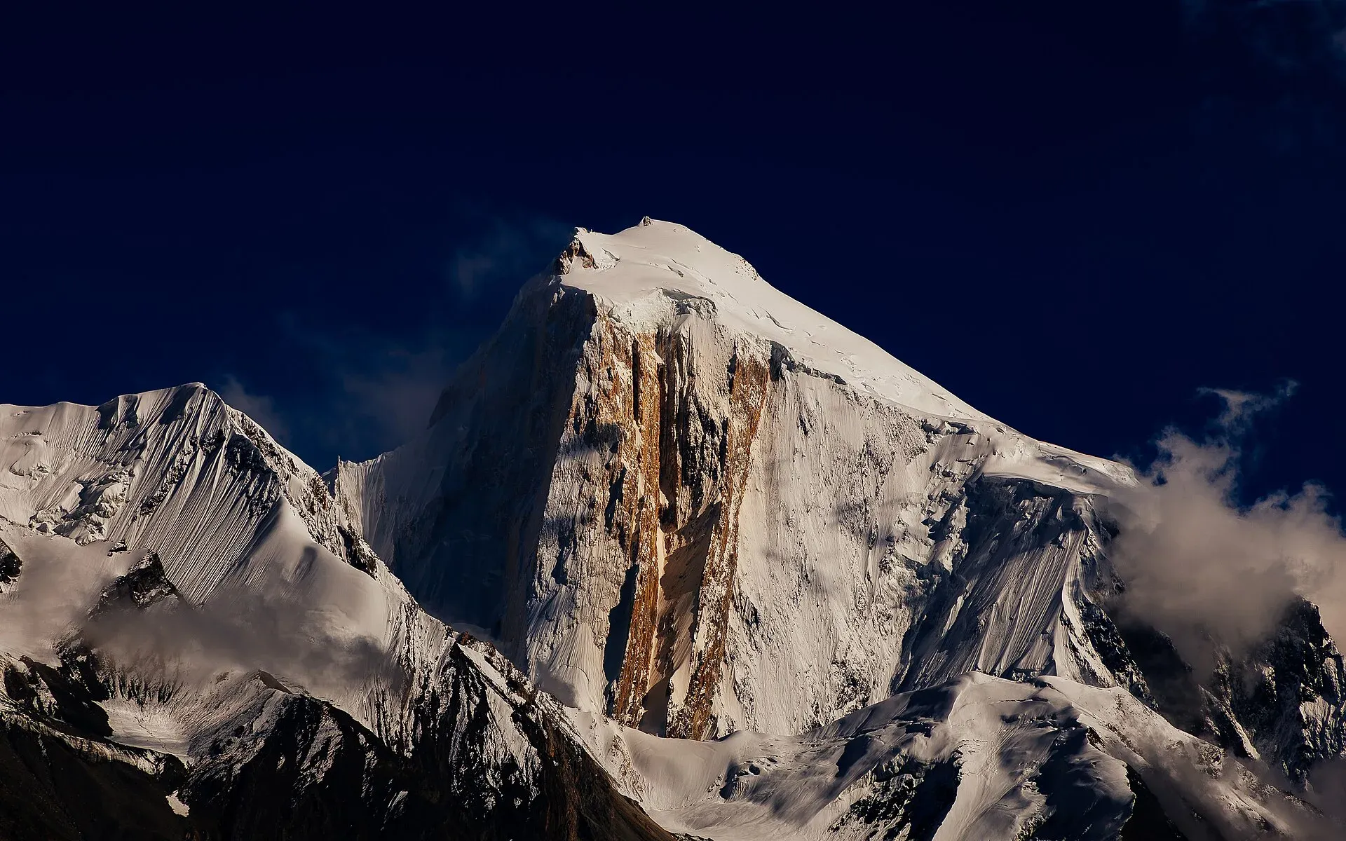
Photo: Muhammad Bin Masood, with thanks · CC BY-SA 4.0 · via Wikimedia Commons · temporary stand-in photo
Barpu Glacier
- Duration
- 6–9 days
- Distance
- 41.9 km
- Grade
- Moderate
- Max altitude
- 4,000 m
- Season
- Jun – Oct
A 6-day glacier trek from Hoper in Nagar along the Barpu Glacier to Girgindil, with views of Spantik, Diran and Ultar and five glacier crossings. A guide is essential.
Overview
The Barpu Glacier is a 33 km river of ice that begins under Malubiting (7,458 m) and the Miar and Phuparash peaks. This trek leaves from Hoper, a cluster of five hamlets in Nagar, and follows the grassy ablation valleys beside the glacier. At the head are the huge north face of Spantik (also called Golden Peak) and a view of Diran and Ultar.
The walking is easy to moderate, but the route has five glacier crossings: the Bualtar twice, then the Barpu, Sumayar Bar and Miar. The Bualtar changes shape every day, so this is not a trek for going alone.
Who it suits
Walkers with some trekking experience who are comfortable on rubble-covered ice. Distances are short and altitudes modest (the highest camp is Girgindil, about 4,000 m), so it is a good first glacier trek with a guide. It is not a route to attempt without local help.
When to go
Mid-June to October. Snow-melt water at Barpugram dries up after May, so early summer and autumn are easier for water. The side trip toward Spantik Base Camp is best from July to September.
The route
From Hoper (about 2,790 m) you drop steeply to the Bualtar Glacier, whose crossing takes from half an hour to three hours. On the far side the trail forks at Lower Shishkin. Take the lower trail east to a notch with the first view of the Barpu, cross it on a worn path (about 45 minutes) and enter the ablation valley on its south-east margin. This is Tagaphari, now dry and bare after the glacier shrank. Barpugram, Mulharai and Bericho Kor (about 3,300 m) follow, with juniper and wild rose along the way.
Beyond Bericho Kor the ablation valley becomes greener. Phahi Phari (about 3,450 m) has water and shade. Chukutans has several huts, and Girgindil (about 4,000 m) has a hut, meadows and a good view of Spantik.
From Girgindil, retrace to Chukutans, cross the Sumayar Bar Glacier and camp at Sumayar Bar (about 3,500 m). Next day cross the wide Miar Glacier, walk down the south-west margin past Hamdar to Hapakun (about 3,250 m), then pass Upper Shishkin and recross the Bualtar to Hoper.
Side trips
- Spantik Base Camp (Shuja Basa, about 4,800 m): three days return from Girgindil, via Makhphona Phari and Yakhzena, on a faint trail. Best July to September.
- Rush Phari (Rush Lake): a steep climb from Bericho Kor. See the Rush Phari trek (rush-phari).
- Dachigan: a boulder with ibex carvings, one hour beyond Bericho Kor.
Some old route notes mention a trail above Barpugram to Fetingish in the Hispar Valley and another to Gutens, a summer settlement that links to Rush Phari.
The peaks above the trail
Spantik, called Golden Peak in English and Ganesh Chish in Burushaski, is 7,027 m high. Fanny Bullock Workman and William Hunter Workman reached a point about 300 m below its summit in 1906, and a German party made the first ascent in 1955. Malubiting (7,458 m) and Diran (7,266 m) lie to the west. Hoper is a base for treks into the glacier-covered Hispar Muztagh. The valley has five glaciers: Hoper, Barpu, Miar, Daranci and Geentur (Supulter).
The ground underfoot
Most of the trek is on grassy ablation valleys: the strips of meadow and boulders that run between the glacier and the valley wall. You cross rubble-covered ice on five glaciers. The Bualtar crossing is the most changeable. Expect steep loose slopes down to the Bualtar on day 1, dry stony ground at Tagaphari, and juniper, wild rose and flowers beyond Bericho Kor. The walking is easy, but the surface moves under your feet, so wear boots with ankle support.
Season
Hoper has heavy snow from November to March, according to Wikipedia, which fits the mid-June to October season above.
Culture and people
Hoper's five villages (Hakalshal, Ratal, Buroshal, Holshal and Gashoshal) share a rota-based porters' union set up in 1999. Hire through it. Parties of five or more porters must also take a sirdar, who is a village representative. The old Mir of Nagar was reported in 1994 to keep a right to collect a camping fee between Tagaphari and Shuja Basa. Ask locally if this still applies.
Practical information
- Guide: a guide or experienced porter is essential for the glacier crossings.
- Water: none between Hoper and Bericho Kor; carry enough and start early.
- Map: Swiss Foundation for Alpine Research 1:250,000 Karakoram (Sheet 1). It wrongly shows Bualtar and Barpu as joined and misplaces Bericho Kor.
- Stages: porters count many short stages, so confirm rates and counts before you set off.
Planning notes
Because porters count short stages, the paid days can be more than the walking days. Agree the plan, rest days and the side trips before you leave Hoper. Keep a spare day for weather, since the Bualtar crossing is more dangerous after rain or heat.
Highlights
- Five glacier crossings in a spectacular setting
- Flowering ablation-valley meadows and juniper
- North face of Spantik (Golden Peak)
- Side trips to Rush Phari and Spantik Base Camp
Day by day
| Day | Camp | Altitude |
|---|---|---|
| 1 | Bericho Kor | 3,300 m |
| 2 | Phahi Phari | 3,450 m |
| 3 | Girgindil | 4,000 m |
| 4 | Sumayar Bar | 3,500 m |
| 5 | Hapakun | 3,250 m |
| 6 | Hoper | 2,790 m |
| Day | Route | Hours | Distance | Ascent / descent | Camp and altitude |
|---|---|---|---|---|---|
| Day 1 | Hoper to Bericho Kor | 4–5 h | 10.8 km | +510 m | Bericho Kor, 3,300 m |
Day 1 notesStart early with all your water: none is reliable until Bericho Kor. Drop steeply to the Bualtar Glacier and cross the broken ice (30 minutes to 3 hours). At Lower Shishkin take the lower trail east, cross the Barpu in about 45 minutes and walk the dry ablation valley past Barpugram and Mulharai to the grassy camp at Bericho Kor, where a trickle of water crosses the site. | |||||
| Day 2 | Bericho Kor to Phahi Phari | 1.5–2 h | 4.1 km | +150 m | Phahi Phari, 3,450 m |
Day 2 notesA short, easy day along the ablation valley. You pass Dachigan after an hour, where a big boulder carries ibex carvings. Phahi Phari has reliable water and shade. You can instead cross the Barpu from Dachigan to Miar (2–3 hours) and return down the other side. | |||||
| Day 3 | Phahi Phari to Girgindil | 3–4 h | 7 km | +550 m | Girgindil, 4,000 m |
Day 3 notesContinue up the now-forested valley with flowers and meadows. Chukutans, with several huts, comes after an hour. Girgindil, with a hut and meadows, is two hours beyond. Walk up the ridge above camp for views of Spantik. Fit groups can add the Spantik Base Camp side trip from here. | |||||
| Day 4 | Girgindil to Sumayar Bar | 4–5 h | 6 km | −500 m | Sumayar Bar, 3,500 m |
Day 4 notesWalk back to Chukutans, then cross the Sumayar Bar Glacier in about an hour to the huts at Sumayar Bar. The huts stand near the meeting of the Sumayar Bar and Miar glaciers beneath a forested ridge. | |||||
| Day 5 | Sumayar Bar to Hapakun | 3.5–4.5 h | 8 km | −250 m | Hapakun, 3,250 m |
Day 5 notesCross the wide Miar Glacier to the Miar settlement, then follow the Barpu's south-west margin. Hamdar is about 1.5 hours from Miar and Hapakun is one hour more. Camp or stay in the huts at Hapakun. | |||||
| Day 6 | Hapakun to Hoper | 3–4 h | 6 km | −460 m | Hoper, 2,790 m |
Day 6 notesWalk through Upper Shishkin, drop to Lower Shishkin and recross the Bualtar Glacier. Take extra care: the route may have moved since you crossed it on day 1. Climb up to Hoper. | |||||
Getting there
Hoper is at the end of a jeep road in the Hoper (Hopar) Valley, Nagar. A daily wagon from Gilgit (about 4.5 hours) was reported around 8 am, with a return around 6 am; special hires run from Karimabad or Ganesh (about 1.5 hours). The road may have changed since 2002, so ask a Karimabad hotel or operator for current times. The trailhead is where the road ends in Hoper.
Permits and rules
- Permit needed
- Usually not, Open zone
- Fee
- Current fees will be added soon
- Last checked
- 16 November 2026
Zone: open. Dawn reported on 29 March 2026 that foreign visitors to open-zone areas do not need a trekking permit, while permits from the Gilgit-Baltistan tourism department are needed only for treks and climbs in restricted zones. Older rules (a 2017 interior-ministry NOC for foreigners) were reported at the time; there is no known 2025-26 source confirming that it still applies. No fee or camping rule was found for this route. Check with the Gilgit-Baltistan Tourism Department in Gilgit, or a local operator, before you go.
How trekking permits, NOCs and registration work: Visa and permits.
Season
Best: Jun – Oct
Water and camps
No dependable water between Hoper and Bericho Kor. Bericho Kor has a small stream. Phahi Phari has reliable water and shade. Barpugram's snow-melt supply is unreliable after May. Camps are grassy sites beside herders' huts. Camping beside huts may involve a fee, so ask.
Gear and safety
Glacier travel is the main hazard. The Bualtar Glacier has no fixed route and can take up to three hours to cross. Use a guide who has crossed in the past few days. Wear boots with good grip, and carry a rope if the glaciers are icy. Girgindil is about 4,000 m, so go up slowly. Rockfall, stream crossings and heat in the lower valley are other hazards. Rescue is by helicopter, and Hoper has no hospital.
Variations
Add Rush Phari (rush-phari) from Bericho Kor or Phahi Phari. Add the three-day Spantik Base Camp return from Girgindil (Shuja Basa, about 4,800 m). Or cross the Barpu from Dachigan to Miar and return along the south-west side.
Tips
- Hire a guide and porters through the Hoper porters' union
- Carry water on day 1 and start early
- Plan extra days: porters count many short stages
- Allow time to acclimatise before Girgindil
- Check the camping fee issue at Tagaphari with locals
Photos we still need: the Barpu or Bualtar glacier crossings, Bericho Kor and Girgindil. Send us yours
Health and emergency
Mobile signal is patchy on most treks, so tell someone your plan before you go. Emergency numbers
Sources and last checked
Last checked Confidence medium7 sources7 still to check
- Last checked
- Method
- Desk research from published sources
- Confidence
- medium
- Checked by
- trek.pk research team
Researched from published sources; not yet checked on the ground by our team. Spot something out of date? Report a mistake.
Sources
- Trekking in the Karakoram and Hindukush (route facts, ~2002) · Lonely Planet · checked
- Gilgit-Baltistan tourism bounces back despite Middle East war (permit rules for open and restricted zones, 29 March 2026) · Dawn · checked
- Rush Lake (Pakistan) - altitude and glacier access · Wikipedia · checked
- Hoper Valley - location and Spantik / Hopar glaciers · Graana · checked
- Hoper Valley (Vertical Explorers) · Vertical Explorers · checked
- Hopar Valley (villages, glaciers, Spantik, seasons) · Wikipedia · checked
- Spantik (height, names, first ascent) · Wikipedia · checked
Still to be checked on the ground (7)
- Current road and transport to Hoper
- Porter union rules and rates, and whether a sirdar is still compulsory
- Whether the Mir of Nagar's camping fee between Tagaphari and Shuja Basa is still collected
- Bualtar and Barpu crossing routes (change yearly)
- Altitudes at Girgindil and Hapakun
- Whether the 2017 interior-ministry NOC for foreigners still applies to open zones
- Spantik is listed in Shigar District by Wikipedia; the Hoper side routes are in Nagar. No route detail was taken from this


