

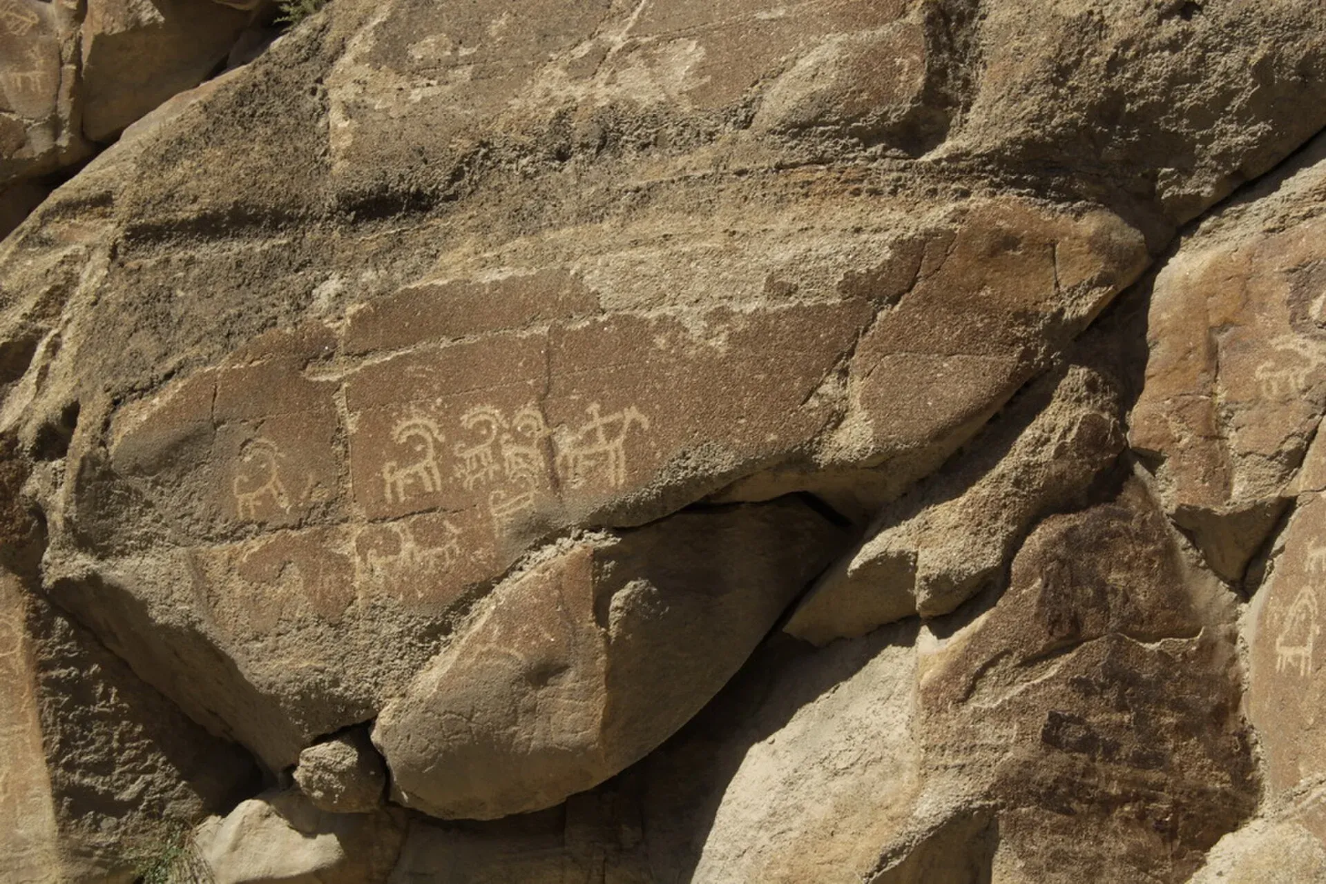
Photo: Baniashirjeel, with thanks · CC BY-SA 3.0 · via Wikimedia Commons · temporary stand-in photo

Sacred Rock of Hunza (Haldeikish)
A 180 m long outcrop of engraved boulders beside the Karakoram Highway near Ganish, with ibex carvings and inscriptions in several ancient scripts from Silk Road travellers.
Overview
The Sacred Rock of Hunza, known locally as Haldeikish, is a hill of engraved boulders on the east side of the Hunza River, along the Karakoram Highway between Ganish village and Attabad Lake. It is about 180 m long and 9 m high at its tallest, made of four main boulders with engravings on two parts. The name is usually translated as "place of many male ibex", and ibex are the most common image.
Plan your visit
- Nearest town
- Karimabad
- Getting there
The rock is on the Karakoram Highway about five minutes' drive from Ganish and close to Karimabad, between Ganish and Attabad Lake. A taxi or hired car from Karimabad is the simplest way. More
Best months
Apr – Oct
- Sacred Rock of Hunza (Haldeikish)
- Related places nearby: Attabad Lake, Gilgit
History
The rock is a record of the Silk Road. The Department of Archaeology and Museums lists it as proto-historic, with a relative date in the 1st millennium BCE; Wikipedia instead says the carvings date to the 1st millennium AD, so treat the date of the oldest carvings as uncertain. Wikipedia lists inscriptions in Sogdian, Kharosthi, Brahmi, Tibetan, Chinese and other scripts. The upper part has inscriptions in Sogdian, Kharosthi, Brahmi, Sarada and Proto-Sarada scripts. They name the Kushan emperors Kanishka and Huvishka and a Trukha king, Ramadusa (Wikipedia). A Sanskrit inscription in Gupta script reads "Chandra Sri Vikramaditya conquers" with a date corresponding to 419 CE. Whether "Chandra" means the Gupta emperor Chandragupta II is uncertain; he may have been a local ruler. The lower part of the rock shows ibex, hunters, horned figures, a figure said to be a Chinese king and a Tibetan-style stupa.
What to see and do
- The engraved boulders: ibex in hunting scenes and many small inscriptions.
- Remains of Buddhist cave shelters: most have collapsed.
- Nearby: Ganish village, with a protected historic core, is a few minutes away.
The site is about five minutes by road from Ganish and near Karimabad, and it was once reached by worn stone steps (Wikipedia). Plan 30 to 45 minutes. Light from the side makes the engravings clearer.
When to visit
April to October. Visit in the morning or late afternoon.
Where to stay and eat
Karimabad, a short drive south, has the main choice of guesthouses and restaurants.
Good to know
- Protection: the Department of Archaeology and Museums lists it as privately owned and "not protected" under law. Wikipedia instead calls it a Cultural Heritage Site of Pakistan, with preservation the responsibility of the Northern Areas administration and the Director of Archaeology. The two accounts do not agree. Be careful with it.
- Etiquette: never touch, rub or mark the carvings, and do not climb the boulders.
- Threat: the rock sits between the river and the highway, and Wikipedia says recent flooding in the Hunza River puts it in danger in future.
- Entry: no official fee or hours were found.
Highlights
- Silk Road inscriptions in many scripts
- Ibex carvings, the name means 'many male ibex'
- Gupta-era inscription dated to 419 CE
- A few minutes from Ganish and Karimabad
Getting there
The rock is on the Karakoram Highway about five minutes' drive from Ganish and close to Karimabad, between Ganish and Attabad Lake. A taxi or hired car from Karimabad is the simplest way.
Tips
- Visit with a local guide who can point out the inscriptions.
- Come in side light.
- Do not touch or climb the rock.
- Combine with Ganish, Baltit and Altit.
Photos we still need: the lower ibex panel and the Buddhist stupa carving. Send us yours
Sources and last checked
Last checked Confidence medium2 sources3 still to check
- Last checked
- Method
- Desk research from published sources
- Confidence
- medium
- Checked by
- trek.pk research team
Researched from published sources; not yet checked on the ground by our team. Spot something out of date? Report a mistake.
Sources
- Sacred Rocks of Hunza (Haldeikish) · Department of Archaeology and Museums, Government of Pakistan · checked
- Haldeikish (Wikipedia) · Wikipedia · checked
Still to be checked on the ground (3)
- Exact access path and any fee (DOAM says only 'easily accessible from the Karakoram Highway'; Wikipedia mentions worn stone steps; no fee found)
- Reading of inscriptions: dates and identities are scholarly interpretations (DOAM says the identification of Chandra with Chandragupta II 'is not certain'); date of the oldest carvings (DOAM: 1st millennium BCE; Wikipedia: 1st millennium AD)
- Legal protection status (DOAM: not protected, privately owned; Wikipedia: Cultural Heritage Site)
Nearby and related

Attabad Lake
A turquoise lake about 21 km long in Gojal, Hunza. It formed when a landslide blocked the Hunza River on 4 January 2010. The Karakoram Highway now passes it through five tunnels.

Gilgit
Gateway to Gilgit-Baltistan on the Karakoram Highway: a busy mountain town with the Kargah Buddha and the base for Hunza, Naltar and Skardu.
Gilgit-Baltistan
Pakistan's far north: three great ranges meet here, with K2, Nanga Parbat, giant glaciers, the Karakoram Highway and the valleys of Hunza, Skardu and Gilgit.