

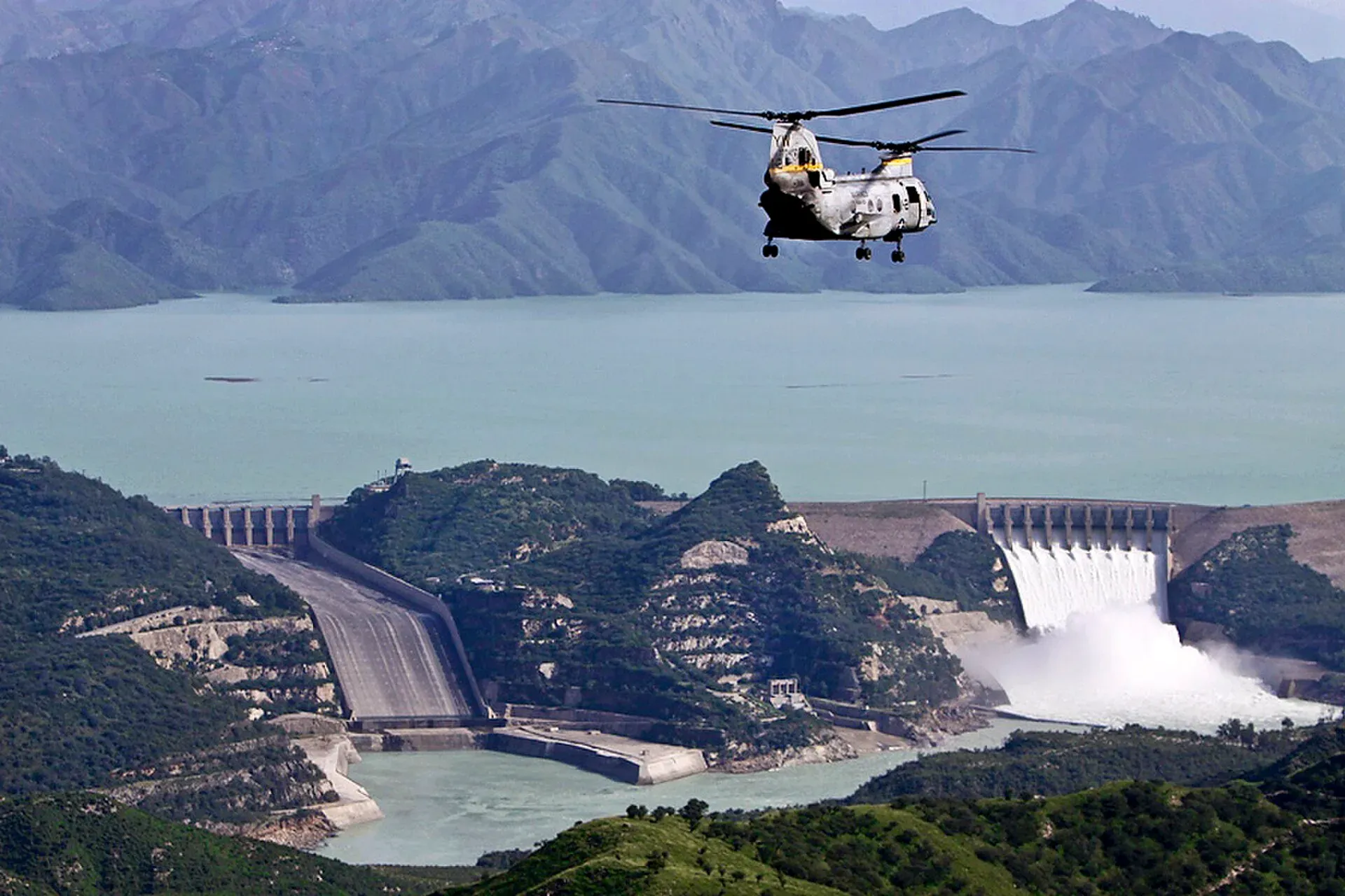
Photo: Paul Duncan, U.S. Marine Corps, with thanks · Public domain (CC0) · via Wikimedia Commons · temporary stand-in photo

Tarbela Dam
A huge earth-and-rockfill dam on the Indus, finished in 1976. It is a working WAPDA power and water site with limited public access, so plan on permission rather than a drop-in visit.
Overview
Tarbela Dam holds back the Indus River about 130 km north-west of Islamabad. WAPDA, which runs it, describes it as one of the world's largest earth and rockfill dams. Its crest is 2,743 m long, at an elevation of 477 m, and WAPDA gives the maximum height above the riverbed as 465 ft (about 148 m). Another reference gives 143 m above the riverbed, so figures differ by where the height is measured from.
Plan your visit
- Nearest town
- Topi
- Getting there
From Islamabad it is about 104 km by road (OSRM, around 1 hour 40 minutes without traffic) towards Topi. Road conditions and any checkpoints change, so confirm the route locally. More
Best months
Mar – May, Sep – Nov
- Tarbela Dam
- Related places nearby: Islamabad, Haripur, Ghazi-Barotha Hydropower Project
Why it was built
The dam is part of the Indus Basin Project, set up under the 1960 Indus Waters Treaty to replace water from the eastern rivers that the treaty assigned to India. Its main purpose is irrigation, and it also generates hydropower. The contract was awarded in May 1968 and the dam was completed in 1976. The river was diverted in three stages: a diversion channel and a buttress dam first, then the main embankment across the valley while tunnels carried the river, and finally the closing of the channel and raising of the dam to full height.
Reservoir and engineering
Tarbela Lake is about 81 km long, with a surface area of about 259 km2 and a maximum depth of about 137 m, according to WAPDA. The Indus carries around 200 million tonnes of sediment a year, so the lake slowly loses storage; one estimate says live storage fell by more than a third in 38 years. Two spillways (seven and nine gates) pass flood water, and a barrage 7 km downstream evens out daily flows into the power channel.
The reservoir flooded 135 villages and displaced about 96,000 people. Damage to the tunnels while the lake was first filling in 1974 to 1975 delayed the project. That is a reminder that the dam is a working piece of national infrastructure, not a park.
Power
Ten 175 MW units, four 432 MW units and three 470 MW units from the fourth extension (finished in 2018) give about 4,888 MW. A fifth extension, converting an irrigation tunnel to hydropower, is under construction.
What to see and do
This is an engineering site first and a tourist spot second. The dam wall, spillways and powerhouse are working infrastructure. WAPDA's own project page gives no visitor hours, fees or rules, and there is no known official public-visit scheme.
- Travel guides say visits need permission from WAPDA's public relations office, and that the powerhouse needs separate approval. This has not been confirmed from an official source.
- The reservoir is seen more easily from the public roads and villages around its edge than from the dam itself.
- A 2005 Dawn report said bathing, fishing and walking beside the downstream lake were banned, and that vehicles had been banned from the dam area after 11 September 2001 over sabotage fears. That report is old, so treat it as a sign of how strict the site can be, not as today's rule.
When to visit
Spring and autumn are the most comfortable. The reservoir is fullest in late summer after the snowmelt, and the dam can look very different between seasons.
Photography and safety
No official photography rule was found. Dams are strategic sites. Do not photograph the powerhouse, intake works, security posts or staff unless told you may, and obey any guard. Do not swim in the reservoir or the downstream pools: currents near the spillways are dangerous.
Good to know
- Location. WAPDA places the dam in Swabi District, Khyber Pakhtunkhwa. Some sources list Haripur District instead.
- Ask the district administration or local police about current conditions before you go. Travel advice. For foreign visitors: the UK FCDO (updated 27 October 2026, checked 16 November 2026) advises against all but essential travel to Swabi and notes KP emergency measures. Read the live page before you plan a trip.
- Fees. Any visit fee is not confirmed; current details will be added soon. Ask WAPDA's Tarbela office.
- Alternatives. Khanpur Dam and Rawal Dam are far easier to visit.
Highlights
- Crest about 2,743 m long
- Completed 1976 on the Indus
- Reservoir about 81 km long
- Working WAPDA site with controlled access
Getting there
From Islamabad it is about 104 km by road (OSRM, around 1 hour 40 minutes without traffic) towards Topi. Road conditions and any checkpoints change, so confirm the route locally. Public transport to the dam itself is limited; most visitors use a car or hired driver.
Tips
- Ask WAPDA's Tarbela office about permission before travelling.
- Do not photograph the powerhouse, security posts or staff.
- Do not swim in the reservoir or the downstream pools.
- Check the FCDO page for Swabi before you go.
Photos we still need: the dam wall or spillways in normal conditions (for the 'Reservoir and engineering' section). Send us yours
Sources and last checked
Last checked Confidence medium4 sources2 still to check
- Last checked
- Method
- Desk research from published sources
- Confidence
- medium
- Checked by
- trek.pk research team
Researched from published sources; not yet checked on the ground by our team. Spot something out of date? Report a mistake.
Sources
- Tarbela Dam · WAPDA · checked
- Tarbela Dam · Wikipedia · checked
- Tarbela Lake declared out of bounds for bathers · Dawn (18 June 2005) · checked
- Foreign travel advice: Pakistan · UK FCDO · checked
Still to be checked on the ground (2)
- Current visitor permission process and photography rules
- Capacity: unit figures on the WAPDA page sum to about 4,888 MW (matching Wikipedia), though that page also lists 5,888 MW
Nearby and related

Islamabad
Pakistan's green, planned capital at the foot of the Margalla Hills: Faisal Mosque, hillside trails, cafes and the gateway to the north.

Haripur
A city in the Hazara plain, about 65 km north of Islamabad and 35 km south of Abbottabad, founded in 1822. A practical stop on the way to the hills and the Karakoram Highway.
Ghazi-Barotha Hydropower Project
A 1,450 MW run-of-river power project on the Indus below Tarbela, with a barrage at Ghazi and a 52 km power channel. Completed in 2004. It is a working WAPDA site, not a visitor attraction.