

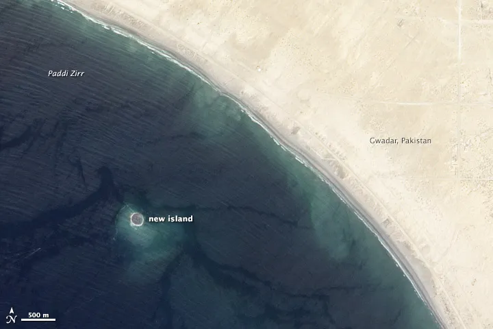
Photo: NASA, with thanks · Public domain (CC0) · via Wikimedia Commons · temporary stand-in photo

Zalzala Koh (Earthquake Island)
A small island, probably a mud volcano, that rose off Gwadar after the earthquake of 24 September 2013. It eroded away and no longer exists.
Read this first
Zalzala Koh no longer exists. It was a short-lived island, so there is nothing to visit. Wikipedia says it had disappeared by the end of 2016. Ask the district administration or local police about current security conditions before you go. For foreign visitors: the UK FCDO (updated 27 October 2026, checked 17 November 2026) advises against all travel to Balochistan Province, which includes this coast.
What happened
Zalzala Koh, also called Zalzala Jazeera or Earthquake Island, appeared off the coast near Gwadar on 24 September 2013, hours after a powerful earthquake in Balochistan. Reports put it about 1.5 to 2 km from the shore. It was most likely a mud volcano. Pakistan's National Institute of Oceanography linked it to methane gas released from the seabed.
The earthquake struck at 16:29 local time. Wikipedia gives its magnitude as 7.8 (the USGS figure cited is 7.7) and places the epicentre in Awaran District, about 113 km north-west of Bela. It left more than 800 people dead, according to the figures Wikipedia gives, and about 100,000 people homeless.
Size and fate
Estimates of the island's size varied. A Dawn report of 25 September 2013 quoted Dr Asif Inam of the National Institute of Oceanography: staff in Gwadar put it at roughly 200 m long, 100 m wide and 20 m high, figures he said still needed scientific checking. Wikipedia gives 15 to 20 m high, 175.7 m long and 160.9 m wide. A Dawn report of December 2016 gave 60 to 70 feet high, up to 300 feet wide and up to 120 feet long. The numbers were debated and none can be treated as exact.
Satellite images showed the island had sunk by about 3 m a month after it appeared. Mud islands of this kind are soft and wash away quickly. Dawn reported on 31 December 2016 that it had gone. The marine biologist Abdul Rahim Baloch told the paper that high tide had made it vanish from the surface, that it remained underwater, and that it could reappear after another strong earthquake.
Why islands appear on this coast
The Makran coastal belt is believed to hold large reserves of methane frozen as gas hydrates, hundreds of metres below the sea floor, according to the National Institute of Oceanography as reported by Dawn. When pressurised gas escapes, it can push up a dome of mud that rises above the water. The area is seismically active, where the Indian, Eurasian and Arabian plates converge.
Zalzala Koh was not the first. Dawn reported islands off the Hingol River mouth in 1999 and 2011, formed without an earthquake and eroded within a short time, and one in the same area in 1945 after an earthquake. Earlier gas samples from the water above Malan Island also contained methane, ethane, propane and butane, and pointed to bacterially generated methane. The surface of Zalzala Koh was lifeless, and flammable gas was reported coming from it.
Afterwards
Wikipedia reports that the surrounding waters became a haven for fish and other marine life, including a coral species, which helped local fishing.
Visiting
There is no island to see. The Gwadar coast has other places to visit, covered on the pages linked here: Gwadar, Hingol National Park and its mud volcanoes, and Astola Island.
Highlights
- Appeared on 24 September 2013 after an earthquake
- Probably a mud volcano
- About 175 m long at its largest, with disputed figures
- Gone by the end of 2016
Getting there
Not applicable; the island has eroded away.
Tips
- Do not plan a trip to see it; it no longer exists.
- Read the live UK FCDO page before any Balochistan travel.
Sources and last checked
Last checked Confidence low5 sources4 still to check
- Last checked
- Method
- Desk research from published sources
- Confidence
- low
- Checked by
- trek.pk research team
Researched from published sources; not yet checked on the ground by our team. Spot something out of date? Report a mistake.
Sources
- Zalzala Koh · Wikipedia · checked
- Pakistan travel advice (updated 27 Oct 2026) · UK Foreign, Commonwealth & Development Office · checked
- 2013 Balochistan earthquakes · Wikipedia · checked
- Island pops up off Gawadar · Dawn (25 Sep 2013) · checked
- Gwadar's quake island disappears · Dawn (31 Dec 2016) · checked
Still to be checked on the ground (4)
- Exact date the island fully disappeared (Dawn, 31 December 2016: gone by the end of 2016)
- Size figures differ between Dawn reports (2013, 2016) and Wikipedia
- Origin: a mud volcano is probable, not confirmed
- Earthquake magnitude: Wikipedia gives 7.8, the USGS entry it cites gives 7.7
Nearby and related

Gwadar
Arabian Sea port town and Gwadar District headquarters, a fishing settlement that Pakistan bought from Oman in 1958 and now a CPEC port.

Hingol National Park
Pakistan's largest national park, about 6,100 square kilometres along the Makran Coastal Highway: desert canyons, mud volcanoes, the Hingol River, the Princess of Hope rock and the Hinglaj Mata temple.

Astola Island
Pakistan's largest offshore island, 6.7 km2, 25 km off the Makran coast and a marine protected area. It is uninhabited, and visits need permission.
Malan Island (Peer Ghaib)
A mud-volcano island off the Balochistan coast that has risen from the sea and sunk again several times. It is not a lasting place to visit.