

Photo: Kamran Adil, with thanks · CC BY-SA 4.0 · via Wikimedia Commons · temporary stand-in photo

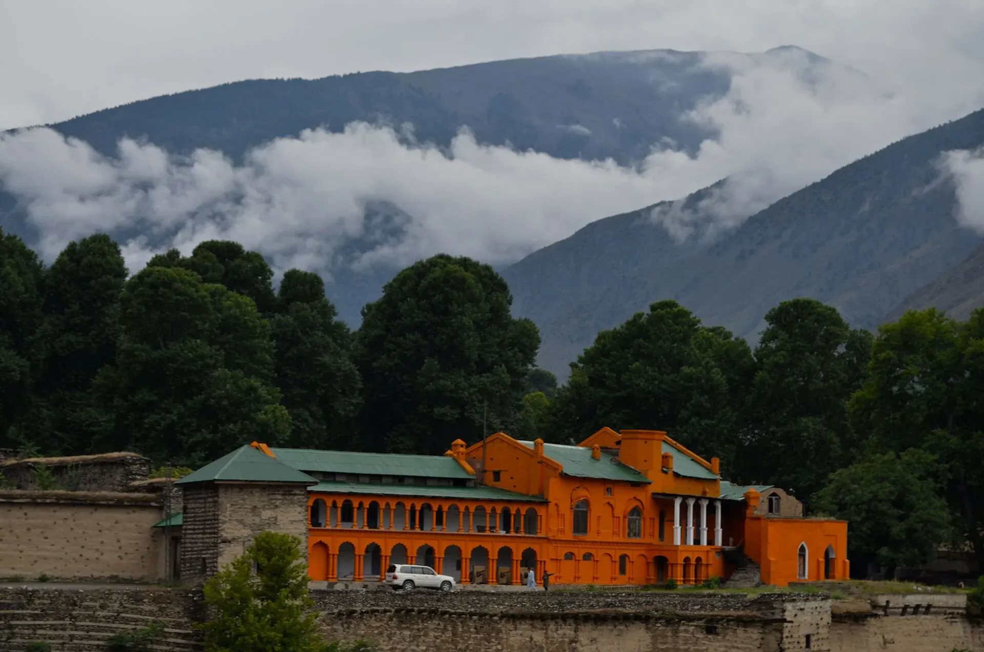
Chitral Fort (Shahi Qila)
The fort and royal residence on the Chitral river, with a history reaching back to the 18th century and the 1895 siege. It is still the home of the ceremonial Mehtar, so access is limited.
Overview
Chitral Fort, also called Shahi Qila or Chitral Palace, stands on the bank of the Chitral river in Chitral town. It was the seat of the Mehtars, the rulers of the former princely state of Chitral. It is thought to date from 1774, in the time of Mohtaram Shah Katur II. Sir Shuja ul-Mulk restored it in 1911.
Plan your visit
- Nearest town
- Chitral
- Getting there
Chitral town is about 341 km by road from Peshawar (roughly 4 hours 15 minutes in OSRM, which does not reflect road closures or the Lowari Tunnel state), via the N-45. The fort is in the town beside the river. More
Best months
Apr – Jun, Sep – Oct
- Chitral Fort (Shahi Qila)
- Related places nearby: Chitral Valley, Kalash Valleys (Bumburet, Rumbur, Birir), Chitral Gol National Park
History
The fort is thought to date from 1774, in the time of Mohtaram Shah Katur II. Sir Shuja ul-Mulk restored it in 1911.
Why it was besieged. The Mehtar Aman ul-Mulk died in 1892, and his sons fought over the throne. Two rulers were murdered in quick succession, and a chief from Jandol, Umra Khan, marched on Chitral with about 3,000 men. Surgeon Major George Scott Robertson, the senior British officer at Gilgit, moved into the fort and installed the 12-year-old Shuja ul-Mulk as Mehtar.
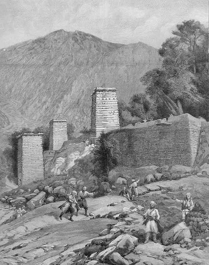
Photo: Illustrated London News (staff artist), with thanks · Public domain (CC0) · via Wikimedia Commons · temporary stand-in photo

The siege of 1895. The fort held 543 people, 343 of them fighting men, including five British officers. The garrison was the 14th Sikhs and a detachment of Kashmiri infantry, with two small mountain guns. Food was expected to last about a month. The fort was about 80 yards square, built of mud, stone and timber, with walls about 25 feet high and 8 feet thick. A short covered way ran down to the river, the only water source. Trees, buildings and nearby hills gave cover to snipers. On 7 April the besiegers set fire to the south-east tower, which burned for five hours but did not fall. The siege lasted about a month and a half and ended on 18 April, when the besiegers withdrew.
Relief. A small force under Colonel James Kelly left Gilgit on 23 March and crossed the 12,000-foot Shandur Pass between 1 and 5 April, dragging its guns on sledges. A larger force of about 15,000 men under Major-General Sir Robert Low came from Peshawar and stormed the Malakand Pass on 3 April. Kelly's column entered Chitral on 20 April. Shuja ul-Mulk went on to rule Chitral until his death in 1936.
After 1969. After the Chitral state merged with Pakistan in 1969, the fort was declared the personal property of the last ruler. It is now lived in by the ceremonial Mehtar, Fateh-ul-Mulk Ali Nasir, who has repaired the old Darbar Hall and state rooms after damage in the 2015 earthquake.
What to see and do
There is no known source that describes a public visiting system, so plan to see the fort from outside, from the riverbank and the road, where its walls and position above the water are clear. Ask locally whether anything has changed. The nearby Shahi Mosque and the bazaar are easy to add.
When to visit
April to June and September to October are comfortable. Winters are cold and the passes can close.
Where to stay and eat
Chitral town has hotels and restaurants. We do not list businesses.
Good to know
- Travel advice. For foreign visitors: the UK FCDO (updated 27 October 2026, checked 16 November 2026) advises against all travel on the N-45 highway up to the edge of Chitral city, including the Kalash valleys. Check the current page and the road status for your route.
- Access. The fort is a private residence. Ask locally, or through your hotel, before trying to go in.
- Etiquette. Dress modestly, ask before photographing family or guards, and respect the household.
- Nearby. Chitral Valley and the Kalash valleys have their own pages.
Highlights
- Royal fort of the Mehtars of Chitral on the river
- Thought to date from 1774; restored 1911
- Scene of the 1895 siege
- Home of the ceremonial Mehtar
Getting there
Chitral town is about 341 km by road from Peshawar (roughly 4 hours 15 minutes in OSRM, which does not reflect road closures or the Lowari Tunnel state), via the N-45. The fort is in the town beside the river. For foreign visitors: the UK FCDO advises against all travel on the N-45 up to the edge of Chitral city; check the current page before planning any overland route.
Tips
- View from the riverbank if you cannot go inside.
- Ask locally about visiting; it is a family residence.
- Check FCDO advice and road status before planning the route.
- Dress modestly.
Sources and last checked
Last checked Confidence medium4 sources5 still to check
- Last checked
- Method
- Desk research from published sources
- Confidence
- medium
- Checked by
- trek.pk research team
Researched from published sources; not yet checked on the ground by our team. Spot something out of date? Report a mistake.
Sources
- Chitral Fort (Wikipedia) · Wikipedia · checked
- Chitral Expedition (Wikipedia) · Wikipedia · checked
- Pakistan Tourism Guide 2021 · Tourism Development Corporation of Pakistan (TDAP) · checked
- Pakistan travel advice: warnings and insurance (updated 27 October 2026) · UK Foreign, Commonwealth & Development Office · checked
Still to be checked on the ground (5)
- Public access rules, hours and any fee (none found)
- 1774 build and 1911 restoration dates come from Wikipedia citing a 2019 Dawn article
- Condition after the 2015 earthquake repairs
- Fort size and wall dimensions are for the 1895 fort (Wikipedia, Chitral Expedition); what survives today is not documented in the sources opened
- Garrison figures: Wikipedia's Chitral Fort article says about 400 British troops, the Chitral Expedition article says 543 people; the higher count is used
Nearby and related

Chitral Valley
The long Chitral River valley at the foot of the Hindu Kush, with Chitral town's fort and Shahi Mosque, the Lowari Tunnel route, Tirich Mir views and side valleys leading to Kalash and Shandur.

Kalash Valleys (Bumburet, Rumbur, Birir)
Three side valleys of the Chitral River, home to the Kalasha people, who keep their own religion, language and festivals. Visit with respect and check security advice first.

Chitral Gol National Park
A mountain park beside Chitral town, set up in 1984 to protect the markhor. About 78 square kilometres rising from 1,450 m to 5,000 m, with snow leopard and ibex.

Khyber Pakhtunkhwa
Mountains, Buddhist ruins and old bazaars in north-west Pakistan: Swat, Kaghan, Chitral, the Kalash valleys, the Khyber Pass and Peshawar.