

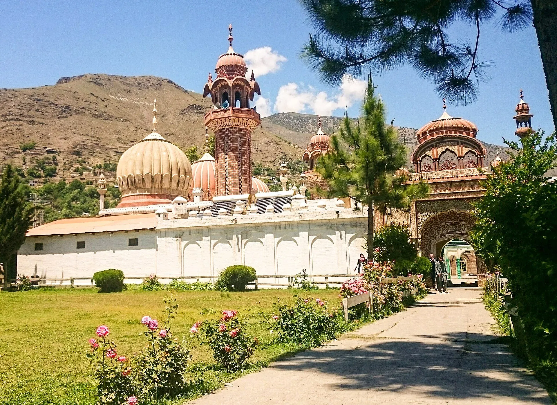
Photo: Fassifarooq, with thanks · CC BY-SA 4.0 · via Wikimedia Commons · temporary stand-in photo

Chitral Valley
The long Chitral River valley at the foot of the Hindu Kush, with Chitral town's fort and Shahi Mosque, the Lowari Tunnel route, Tirich Mir views and side valleys leading to Kalash and Shandur.
Overview
Chitral is a district of deep river valleys in the north-west of Khyber Pakhtunkhwa, close to the Afghan border. Chitral town, on the Chitral River at about 1,500 m, is the main base. Tirich Mir, the Hindu Kush's highest peak at 7,708 m, rises to the north of the valley. Wikipedia describes the town's climate as dry, with very hot summers, almost no summer rain and cold winters with night frost. The high ground is deeply snowbound in winter.
Chitral was a princely state until 1969. Its rulers, the Katur dynasty, held power from 1571. In 1895 a British garrison in Chitral Fort was besieged for about a month before being relieved. In November 2018 the former district was split into Lower and Upper Chitral.
Plan your visit
- Nearest town
- Chitral
- Getting there
By road from Islamabad via Dir and the Lowari Tunnel (N-45): OSRM about 402 km and 4.6 h, optimistic; allow 8 to 10 hours. More
Best months
May – Oct
- Chitral Valley
- Related places nearby: Kalash Valleys (Bumburet, Rumbur, Birir), Chitral Gol National Park, Drosh, Booni, Biori Valley
Getting there
Three ways in. The first is by road through the Lowari Tunnel on the N-45 from Dir, which is now the main route. Wikipedia gives the two tunnels' combined length as 10.4 km, and the tunnel was completed in 2017. Dawn reported in September 2018 that it was open for 10 to 12 hours a day, and current hours are not confirmed, so ask the National Highway Authority or a driver. OSRM gives Islamabad to Chitral at about 402 km and 4.6 hours. OSRM times are optimistic, and most people allow a full day (8 to 10 hours).
The second is by air. Wikipedia, citing Dawn of 19 March 2025, says PIA announced it would resume Islamabad to Chitral flights from 5 April 2025 after a gap of about three years, at first once a week. The current schedule is not confirmed. Flights are weather-dependent and are cancelled often, so book flexibly and check the current schedule with PIA.
The third is the Shandur Pass road from Gilgit, which is open in summer. Shandur Pass is about 212 km from Gilgit, according to Wikipedia.
Within the valley, shared jeeps run from Chitral town to Mastuj and into the Kalash valleys, according to a travel guide (Wikivoyage, undated). Kalash-valley jeeps leave in the morning and mid-afternoon, and an entry toll applies to the valleys. Ask locally for current fares and tolls.
Villages and sights
- Chitral Fort (Chitral Palace). Believed to be built in 1774, restored in 1911, beside the river. It is the home of the ceremonial ruler, so ask about visiting arrangements.
- Shahi Mosque. Built beside the fort in 1924 on the orders of Shuja ul-Mulk.
- Chitral Gol National Park. A protected area just outside town, known for markhor.
- Kalash valleys. Bumburet, Rumbur and Birir, about 30 km south of Chitral by OSRM (0.7 hour), described on their own page.
- Booni, Mastuj and Laspur. Villages up the Mastuj valley towards Shandur, described on the Laspur page.
- Broghil. A high, remote valley in the far north, now a national park.
A day or two in Chitral
One way to use two days, built from the sights above. On the first day, walk along the river to Chitral Fort and the Shahi Mosque, then look at Chitral Gol National Park on the edge of town. On the second day, take a jeep to the Kalash valleys (about 30 km south by OSRM, roughly 0.7 hour) and spend the day in Bumburet, Rumbur or Birir, returning before dark. Add a third day for the Mastuj valley if you are heading for Shandur.
Treks and walks
Chitral has many high routes. Kasavir and the Gokhshal An and Dooni An routes use Chitral Gol and Rumbur, and Kachakani An crosses from Ushu Gol to Sor Laspur. See Other treks in Chitral for the full list. High passes and the Wakhan border zone have restrictions, so check with your operator before any pass crossing.
When to visit
May to October is easiest. Spring and early summer have blossom in the lower villages. The Shandur Polo Festival is a summer event, and in 2026 it ran from 11 to 13 June, according to Dawn; dates change each year, so check ahead. October brings autumn colour. Winter is cold, and heavy snow can interrupt the Lowari route and the Shandur road.
Where to stay and eat
Chitral town has hotels and guest houses for all budgets, and shops and cash machines. Food is Chitrali: bread, lamb and mutton dishes, walnut and dried-fruit sweets, and salted tea. Smaller villages up the valley have simple rooms.
Culture and languages
Khowar is the main language, spoken by nearly all residents of the town according to the 1981 census cited by Wikipedia. Kalasha, Wakhi, Kyrgyz and Pashto are also spoken in the district, and Urdu is the lingua franca. Chitral is known for polo and for music. Wikivoyage dates the three main Kalash festivals as Joshi (14 to 15 May), Uchau (19 to 20 August, for grapes and ripe fruit) and Choimus (7 to 22 December); the dates are set locally, so check with a guide before planning around them. Most people are Muslim, with Sunni and Ismaili communities, and the Kalash people follow their own religion.
Safety and practical points
- Security advice. The UK Foreign Office advises against all travel on the N-45 from Mardan to the edge of Chitral City, including the Kalash valleys (advice last updated 27 October 2026, checked 16 November 2026). It does not name Chitral City itself. Read the advice and check with local sources.
- Roads. Landslides and floods can cut roads. The Lowari Tunnel can close in bad weather.
- Flights. Allow spare days: cancellations are common in cloud and wind.
- Foreign visitors. Foreign visitors should expect to need a no-objection certificate (NOC). KP's tourism department launched an online NOC system for foreign tourists in July 2025 (Dawn, 12 July 2025), and a Senate committee was told in May 2026 that foreign tourists must get an NOC before visiting Chitral (Express Tribune, 6 May 2026). As of November 2026 no later notice has been found. Apply through KP Tourism or a licensed operator, and ask them about the Kalash valleys and border zones.
Highlights
- Chitral Fort and Shahi Mosque
- Views of Tirich Mir (7,708 m)
- Lowari Tunnel road from Dir
- Gateway to Kalash, Shandur and Broghil
- Chitral Gol National Park
Tips
- Allow a full day by road from Islamabad.
- Book flights with spare days in case of cancellation.
- Check Lowari Tunnel hours and snow before travelling.
- Ask a local operator about current permits for border-zone treks.
Photos we still need: Chitral bazaar or local food (Where to stay and eat); a trek or high pass in Chitral (Treks and walks). Send us yours
Sources and last checked
Last checked Confidence medium16 sources5 still to check
- Last checked
- Method
- Desk research from published sources
- Confidence
- medium
- Checked by
- trek.pk research team
Researched from published sources; not yet checked on the ground by our team. Spot something out of date? Report a mistake.
Sources
- Chitral (Wikipedia) · Wikipedia · checked
- Chitral Fort (Wikipedia) · Wikipedia · checked
- Shahi Mosque, Chitral (Wikipedia) · Wikipedia · checked
- Lowari Tunnel (Wikipedia) · Wikipedia · checked
- Shandur Pass (Wikipedia) · Wikipedia · checked
- Chitral awaits tourists · Dawn · checked
- Shandur polo festival to begin on June 11 · Dawn · checked
- Pakistan travel advice (last updated 27 October 2026) · UK FCDO · checked
- Pakistan Tourism Guide 2021 · TDAP · checked
- OSRM routing · Project OSRM · checked
- Chitral Airport (Wikipedia) · Wikipedia · checked
- Lowari tunnel: opportunities and challenges · Dawn · checked
- Entry requirements, Pakistan travel advice · UK FCDO · checked
- Chitral (Wikivoyage) · Wikivoyage · checked
- Online NOC for foreign tourists launched (12 July 2025) · Dawn · checked
- Senate panel flags hurdles to Chitral tourism (6 May 2026) · The Express Tribune · checked
Still to be checked on the ground (5)
- Current Lowari Tunnel operating hours (Dawn, 30 Sep 2018: 10 to 12 hours a day; no current notice found)
- Current PIA flight schedule (announced as resuming April 2025, once a week; not confirmed since)
- Whether Chitral Fort can be visited (Wikipedia says the ceremonial Mehtar lives there; no visiting rules found)
- Kalash festival dates (Wikivoyage, undated): Joshi 14 to 15 May, Uchau 19 to 20 August, Choimus 7 to 22 December; confirm with local sources each year
- Scope of the KP NOC for Chitral treks and the Kalash valleys (the KP Tourism portal itself has not been opened)
Nearby and related

Other treks in Chitral
Kasavir (Chitral Gol National Park)

Gokhshal An and Dooni An

Kachakani An

Kalash Valleys (Bumburet, Rumbur, Birir)
Three side valleys of the Chitral River, home to the Kalasha people, who keep their own religion, language and festivals. Visit with respect and check security advice first.

Laspur Valley
A high side valley in Upper Chitral on the road to Shandur Pass, with Mastuj, Sor Laspur and lakes, and trek links to Swat and Ghizer. Information is limited, so confirm road and rules locally.

Chitral Gol National Park
A mountain park beside Chitral town, set up in 1984 to protect the markhor. About 78 square kilometres rising from 1,450 m to 5,000 m, with snow leopard and ibex.

Broghil Valley National Park
A remote high valley at the northern tip of Chitral beside the Wakhan Corridor, with about 30 lakes, glaciers, Wakhi and Kyrgyz communities and rare wildlife. Reached only by a long mountain drive.

Khyber Pakhtunkhwa
Mountains, Buddhist ruins and old bazaars in north-west Pakistan: Swat, Kaghan, Chitral, the Kalash valleys, the Khyber Pass and Peshawar.

Drosh
A river town at about 1,359 m in Lower Chitral, on the N-45 road south of Chitral city. It is the largest town in Lower Chitral after Chitral itself and a common stop on the way to the Kalash valleys.

Booni
Headquarters of Upper Chitral District at about 2,085 m, near the foothills of Buni Zom and the Qaqlasht meadows. It is a base for local walks and a stop on the road to Mastuj and Shandur.
Mastuj
The main settlement of Mastuj valley in Upper Chitral, at about 2,359 m. It has an old fort ruin, big mountain views, and is the last major stop on the road to Shandur Pass and Gilgit.
Biori Valley
A small valley in Upper Chitral where the Palula language is spoken, near Drosh. A cultural and language interest more than a tourist stop.