

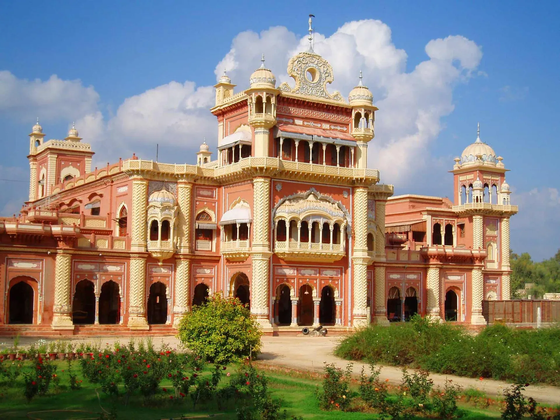
Photo: Arsalanrkazi at English Wikipedia, with thanks · Public domain (CC0) · via Wikimedia Commons · temporary stand-in photo

Khairpur
Former capital of the Talpur princely state of Khairpur and now district headquarters, 24 km from Sukkur, home of Faiz Mahal. For foreign visitors: the UK FCDO advises against all but essential travel here.
Overview
Khairpur is the capital of Khairpur District in northern Sindh, and was the seat of the Talpur princely state of Khairpur. The 2023 census counted 191,044 people in the city (CityPopulation.de, from the Pakistan Bureau of Statistics; Wikipedia agrees). In the city's urban taluka 95 per cent of people gave Sindhi as their first language in 2023.
Plan your visit
- Nearest town
- Sukkur
- Getting there
Road: Sukkur about 24 km (about 20 minutes, optimistic OSRM estimate). Nearest airport and rail junction at Sukkur. More
Best months
Nov – Mar
- Khairpur
- Related places nearby: Sukkur, Kot Diji, Moenjodaro, Nara Desert, Mehrano Wildlife Sanctuary
History
The Talpur dynasty took power in Sindh in 1783 under Mir Fateh Ali Khan, who defeated the Kalhoras at the Battle of Halani. Mir Sohrab Khan Talpur founded the Khairpur branch, and power passed to his eldest son Mir Rustam Ali Khan in 1811. Rustam ruled until 1842, then gave way to his youngest brother, Mir Ali Murad.
The Khairpur rulers sided with the British. Ali Murad helped them in the 1845 to 1847 campaign and again in the 1857 uprising, though he was accused of plotting against them in 1851 to 1852 and lost his upper Sindh lands. In 1866 the British promised to recognise his successors, and the state kept a reduced territory. Khairpur joined Pakistan as a princely state in 1947 and was merged into the country in 1955.
What to see and do
The main landmark is Faiz Mahal, the palace of the Talpur rulers of Khairpur. Wikipedia says Mir Sohrab Khan built it in 1798 in a Rajput and Mughal style as the main court building of the royal palace complex. It had the ruler's chambers, 16 waiting rooms for courtiers, guest rooms, a durbar (audience hall), dining halls, a Hathi Khana (elephant house), and stables where a mango orchard now stands. It is the home of the last ruler's family, so it is a private residence. There are no known official visiting arrangements, so ask locally. Beyond that, the old bazaars are the town's character.
Kot Diji
Wikipedia describes it as an ancient site about 45 km south of Khairpur on the east bank of the Indus, opposite Mohenjo-daro, at the foot of the Rohri Hills. The fort, built around 1790 by Mir Suhrab, stands on a steep, narrow hill and is described as well preserved. The mound below gave its name to the Kot Diji culture, an Early Harappan phase of the Indus Valley Civilisation dated to roughly 3300 to 2600 BCE. Excavations by the Department of Archaeology in 1955 and 1957 found wheel-thrown red jars decorated with fish scales and pipal leaves, a toy cart, bangles and beads. See Kot Diji.
Wildlife and heritage nearby
The last Talpur ruler is described by Wikipedia as an environmentalist who oversees the Mehrano reserve, a sanctuary known for blackbuck and hog deer; see Mehrano Wildlife Sanctuary. Moenjodaro, the best-known Indus city, is further west in Larkana District (Moenjodaro). Siraj-ji-Takri is another archaeological site in the district.
Climate
Khairpur has a hot desert climate. Wikipedia reports summer temperatures regularly above 50 C, a record high of 50.5 C in May and June, and says it was described as the hottest city in British India. Annual rainfall averages about 88 mm. Winter nights can fall below freezing; the recorded low is minus 1.5 C. November to March is the practical time to visit.
Why you might pass through
Khairpur is on the highway system just south of Sukkur, and it is close to Kot Diji, a significant archaeological and fort site.
Getting there
OSRM estimates Sukkur at about 24 km and 20 minutes by road (optimistic estimate, checked 16 November 2026). Sukkur has the nearest airport and a major railway junction.
Services
Expect the basic services of a district headquarters: a government district hospital and private clinics, pharmacies, fuel stations on the main roads and a central bazaar. Shah Abdul Latif University and a medical college are based in the city. ATMs are most likely in the main bazaar or along the highway. We have no verified list of individual businesses, so confirm what you need in the larger city before you arrive.
Safety
For foreign visitors: the UK FCDO advises against all but essential travel to Sindh north of and including Nawabshah (page updated 27 October 2026; checked 17 November 2026), and this town falls inside that area. We do not recommend it for leisure travel. If your travel is essential, read the current FCDO page, check local conditions, avoid night driving and carry identification. The FCDO also notes a general risk of terrorism across Pakistan.
Highlights
- Seat of the Talpur princely state of Khairpur
- Faiz Mahal
- Old bazaars
- 24 km from Sukkur
Stay, eat and essentials in Khairpur
Places to stay
- Circuit HouseMap of Circuit House in Google Maps
- MUET SZAB Campus Hostel 2Map of MUET SZAB Campus Hostel 2 in Google Maps
- IMPERIAL BANQUET AND HOTELCall IMPERIAL BANQUET AND HOTELMap of IMPERIAL BANQUET AND HOTEL in Google Maps
- Foreign Faculty Guest House 16suitsCall Foreign Faculty Guest House 16suitsMap of Foreign Faculty Guest House 16suits in Google Maps
- MUET SZAB Campus Hostel 1Call MUET SZAB Campus Hostel 1Map of MUET SZAB Campus Hostel 1 in Google Maps
- IRC Guest House KhairpurCall IRC Guest House KhairpurMap of IRC Guest House Khairpur in Google Maps
Places to eat
- Jan Bakers and SweetsCall Jan Bakers and SweetsMap of Jan Bakers and Sweets in Google Maps
- Cafè KhazanaMap of Cafè Khazana in Google Maps
- The Hunger SolutionCall The Hunger SolutionMap of The Hunger Solution in Google Maps
- Ahmed Biryani & Bar BQCall Ahmed Biryani & Bar BQMap of Ahmed Biryani & Bar BQ in Google Maps
- Canal View (ڪينال ويو)Call Canal View (ڪينال ويو)Map of Canal View (ڪينال ويو) in Google Maps
- Faqeera Zone cafeCall Faqeera Zone cafeMap of Faqeera Zone cafe in Google Maps
Essential services fuel stations, mechanics, ATMs, pharmacies and hospitals and clinics
Fuel
- PSO Petrol PumpMap of PSO Petrol Pump in Google Maps
- Mehran Petrol PumpMap of Mehran Petrol Pump in Google Maps
- Khairpur Filling Station- Total Petrol StationCall Khairpur Filling Station- Total Petrol StationMap of Khairpur Filling Station- Total Petrol Station in Google Maps
- Pakistan State Oil (PSO)Call Pakistan State Oil (PSO)Map of Pakistan State Oil (PSO) in Google Maps
- Attock Petroleum ServiceCall Attock Petroleum ServiceMap of Attock Petroleum Service in Google Maps
- Taj Filling StationMap of Taj Filling Station in Google Maps
Mechanics and tyre shops
- ZAMIN AUTOS KUTCHERY ROAD KHAIRPURCall ZAMIN AUTOS KUTCHERY ROAD KHAIRPURMap of ZAMIN AUTOS KUTCHERY ROAD KHAIRPUR in Google Maps
- Sana AutosCall Sana AutosMap of Sana Autos in Google Maps
- Ibupota AutosCall Ibupota AutosMap of Ibupota Autos in Google Maps
- Zam Zam AutosMap of Zam Zam Autos in Google Maps
ATMs
- MCB Bank LTDMap of MCB Bank LTD in Google Maps
- Habib BankMap of Habib Bank in Google Maps
- NBP Luqman Phatak ATMMap of NBP Luqman Phatak ATM in Google Maps
- National Bank of Pakistan ATMMap of National Bank of Pakistan ATM in Google Maps
- HBL ATMMap of HBL ATM in Google Maps
- BankIslami - Khair Pur BranchCall BankIslami - Khair Pur BranchMap of BankIslami - Khair Pur Branch in Google Maps
Pharmacies
- Memon Medical and General Store luqman Khairpur mir'sCall Memon Medical and General Store luqman Khairpur mir'sMap of Memon Medical and General Store luqman Khairpur mir's in Google Maps
- SaadSaarim Medical Centre khairpur (Dr.Zulekhan Mallah)Call SaadSaarim Medical Centre khairpur (Dr.Zulekhan Mallah)Map of SaadSaarim Medical Centre khairpur (Dr.Zulekhan Mallah) in Google Maps
- Hoor Medical and General StoreCall Hoor Medical and General StoreMap of Hoor Medical and General Store in Google Maps
- Al Noor Medical StoreCall Al Noor Medical StoreMap of Al Noor Medical Store in Google Maps
- AHMED MEDICAL STORECall AHMED MEDICAL STOREMap of AHMED MEDICAL STORE in Google Maps
- Mashallah pesticide ShopCall Mashallah pesticide ShopMap of Mashallah pesticide Shop in Google Maps
Hospitals and clinics
- Kausar Hospital, KhairpurCall Kausar Hospital, KhairpurMap of Kausar Hospital, Khairpur in Google Maps
- Ali Medical CenterCall Ali Medical CenterMap of Ali Medical Center in Google Maps
- Shifa Medical CentreCall Shifa Medical CentreMap of Shifa Medical Centre in Google Maps
- Maternity Home Luqman (ميٽرنٽي هوم لقمان)Map of Maternity Home Luqman (ميٽرنٽي هوم لقمان) in Google Maps
- Mutahar Medical CentreMap of Mutahar Medical Centre in Google Maps
- Shahani Bone Care CentreCall Shahani Bone Care CentreMap of Shahani Bone Care Centre in Google Maps
Listings come from Google Maps data and are unverified: phone numbers, opening months and prices may have changed. Report a problem · Own one of these? Claim it
Tips
- Check the FCDO page before any travel: all but essential travel is advised against.
- Visit between November and March; summers are extreme.
- Ask locally about Faiz Mahal access.
- Combine with Sukkur and Kot Diji only if travel is essential.
Sources and last checked
Last checked Confidence medium8 sources3 still to check
- Last checked
- Method
- Desk research from published sources
- Confidence
- medium
- Checked by
- trek.pk research team
Researched from published sources; not yet checked on the ground by our team. Spot something out of date? Report a mistake.
Sources
- Khairpur · Wikipedia · checked
- Khairpur District: 2023 census · CityPopulation.de · checked
- OSRM public routing demo (driving, optimistic) · Project OSRM · checked
- Pakistan travel advice · UK Foreign, Commonwealth & Development Office (FCDO) · checked
- Khairpur (city population, 2017 and 2023 censuses) · CityPopulation.de · checked
- Faiz Mahal · Wikipedia · checked
- Kot Diji (Wikipedia) · Wikipedia · checked
- Khairpur District (Wikipedia) · Wikipedia · checked
Still to be checked on the ground (3)
- Faiz Mahal access arrangements (Wikipedia says it is a family home; no official visiting information found)
- Local crafts, produce and bazaar specialities (no source found)
- Access to Kot Diji Fort and any fee (no official source)
Nearby and related

Sukkur
Sindh's third-largest city on the Indus, with the 1932 Sukkur Barrage, the 1889 Lansdowne Bridge, Masum Shah's Minaret and the river islands of Rohri.

Kot Diji
A fort on a rocky hill in Khairpur district, built by the Talpurs in the late 18th century, below an early Indus-era town that gave its name to the Kot Dijian culture. Across the Indus from Moenjodaro.

Moenjodaro
The ruins of a planned Indus Valley city built around 2500 BCE, with brick streets, drains and the Great Bath. A UNESCO World Heritage Site since 1980, about 30 km from Larkana in Sindh.

Sindh
Pakistan's south-east: Karachi's beaches and markets, the Indus Valley city of Moenjodaro, Thatta's Makli tombs, Sufi shrines, the Thar desert and the Indus delta.
Nara Desert
A sandy desert of about 23,000 km2 in Khairpur and Sanghar districts, Sindh, northeast of the Indus. Very hot and dry, with little tourism. The FCDO advises against all but essential travel to this part of Sindh.
Mehrano Wildlife Sanctuary
A 280-hectare riverside forest near Kot Diji in Khairpur District, Sindh, kept by the Talpur Mir family and endorsed by the Sindh Wildlife Department. Blackbuck, Indian gazelle and hog deer are recorded. Visitor access is not published.