

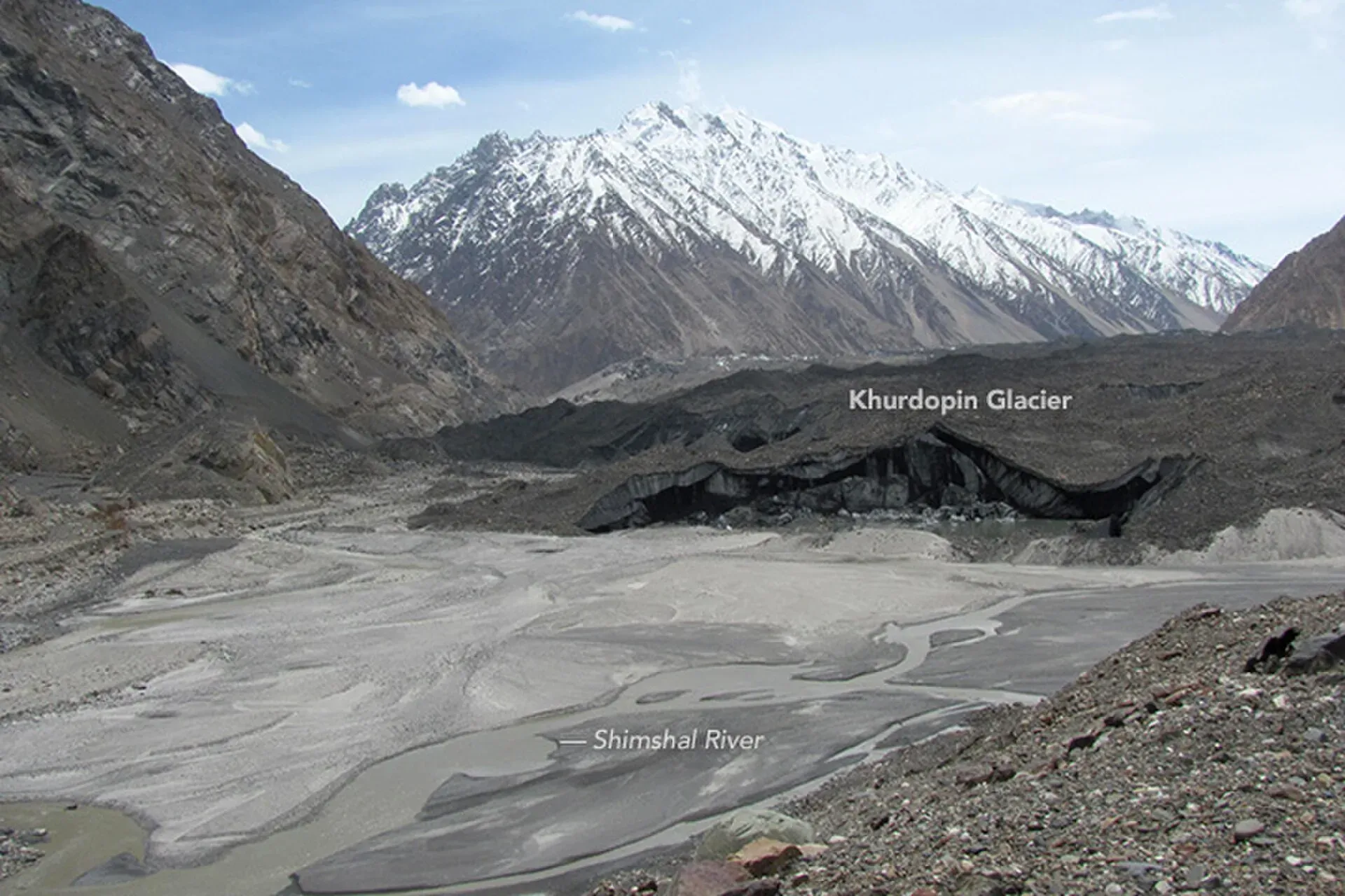
Photo: Waheed Anwar and NASA Earth Observatory, with thanks · Public domain (CC0) · via Wikimedia Commons · temporary stand-in photo

Khurdopin Glacier (Shimshal)
A surging glacier above Shimshal. A 2017 surge dammed the river and formed a lake that drained in July and August, cutting the valley off for about a week.
Overview
The Khurdopin Glacier is in the Shimshal Valley, Gojal, Hunza, Gilgit-Baltistan. A 2018 paper in The Cryosphere (Steiner and others) gives about 41 km in length and about 1.5 km in width, with a main tongue of about 25 km and an elevation range of about 3,300 to 7,760 m. Our Other treks in Gojal page gives 37 km, so lengths vary between about 37 and 41 km by source. The lower 10 km of the tongue is heavily covered in debris, and bands of debris that meander across the ice are visible up to 20 km from the end, a typical sign of a surge-type glacier.
Khurdopin is one of three sources of the Shimshal River. The Khurdopin Pass (5,790 m) crosses it and is an extreme mountaineering route from Shimshal.
Plan your visit
- Nearest town
- Passu
- Getting there
From Passu on the Karakoram Highway, 4x4 road to Shimshal (about 55 km, 2.5 hours). The glacier is above the village. More
Best months
Jun – Sep
- Khurdopin Glacier (Shimshal)
- Related places nearby: Gojal and Shimshal, Yazghil Glacier (Shimshal), Virjerab Glacier (Shimshal)
Surges and the 2017 lake
The glacier is known for surging, meaning it speeds up sharply for a short time after years of quiet build-up. Steiner and others record surges in 1979, 1999 and 2017, a return period of about 20 years. Peak speeds reached about 4,000 m a year in 1979 and 1999 and about 5,200 m a year in early June 2017, among the fastest recorded for a mountain glacier. By September most of the ice was moving below 200 m a year.
After the 1999 surge ice built up over about four years above a steep section about 12 km up-glacier. The 2017 surge began rapidly in May and pushed the tongue up by 50 to 160 m on the surging section. The end of the glacier did not visibly advance, because it was buried in a stable moraine.
The tongue blocked the Vijerab River and a lake formed from late April 2017 at the same site as after 1999. It grew from about 72,000 cubic metres in early May to about 2 million cubic metres on 28 June, then drained from around 21 July and was gone by 5 August. The outflow washed away a road in several places, destroyed at least one main bridge, eroded farmland and cut the valley off for about a week. The authors warned that a future lake could be larger. Wikipedia dates the surge to 2016-17; the paper dates the rapid surge to 2017.
History of floods
The paper lists possible lake-drainage floods after surges in 1901 or 1904, 1923, 1944 and 1960. Earlier drainage of Khurdopin Lake destroyed villages downstream, and the paper notes that this led to an early warning system of bonfires lit on the slopes of the Shimshal Valley. A NASA satellite image from May 2017 shows the tongue pushing into the river.
What to see and do
The glacier is not a tourist walk. Shimshal villagers know its state; ask locally before travelling on the river routes.
Shimshal
Shimshal village sits at about 3,113 m and is the highest settlement in Hunza District. Wikipedia says about 3,000 people live in four hamlets, speak Wakhi and follow the Ismaili tradition. A cellular network reached the village in 2016. The community runs the Shimshal Nature Trust and a self-help system called Nomus. Shimshal Pass (4,735 m) hosts an annual yak race, and Wikivoyage lists the Yazghil Glacier, a few hours' walk up the valley, with shepherds' huts. See Gojal and Shimshal and Yazghil Glacier.
Getting there
Shimshal is reached by a 4x4 road of about 55 km from the Karakoram Highway about 5 km north of Passu (Wikivoyage); Wikipedia says a road built in 2003 connects the village to the highway. Jeeps run daily and the drive takes about 2.5 hours. The road is one vehicle wide in places, with cliff-side sections and drops to the valley, and Wikivoyage notes that floods had destroyed some bridges by 2019, so there are small but potentially dangerous river crossings. Foreigners sign in with the police at the start of the road, after the suspension bridge over the Hunza river. The glacier is above the village. Check river and road conditions before any trip.
When to visit
June to September is the usual Shimshal trekking season.
Where to stay and eat
Shimshal village has home stays and simple guesthouses. Supplies are limited.
Good to know
- Travel advice. For foreign visitors: the UK FCDO page for Pakistan (updated 27 October 2026, checked 17 November 2026) does not advise against Gilgit-Baltistan as a whole. It does advise against all travel on the Karakoram Highway between Mansehra and Chilas, and against travel within 10 miles of the Line of Control. Check the live page for your route.
- Safety. Surges and ice-dammed lakes have blocked the river and caused floods. Ask locals about current conditions. A satellite messenger is advisable.
- Fees and permits. No visitor fees are published. Current fees will be added soon.
Highlights
- About 37 to 41 km long, depending on source
- Surges about every 20 years (1979, 1999, 2017)
- 2017 lake drained July to August
- Source of the Shimshal River (one of three)
Tips
- Ask Shimshal villagers about the river before travelling.
- Do not travel the road after heavy rain.
- Carry a satellite messenger.
Photos we still need: Shimshal village or the Shimshal road (Getting there); the Khurdopin glacier tongue from the ground. Send us yours
Sources and last checked
Last checked Confidence medium4 sources4 still to check
- Last checked
- Method
- Desk research from published sources
- Confidence
- medium
- Checked by
- trek.pk research team
Researched from published sources; not yet checked on the ground by our team. Spot something out of date? Report a mistake.
Sources
- The Khurdopin glacier surge revisited: extreme flow velocities and formation of a dammed lake in 2017 · The Cryosphere (Steiner et al., 2018) · checked
- Shimshal Valley · Wikipedia · checked
- Shimshal · Wikivoyage · checked
- Foreign travel advice: Pakistan · UK FCDO · checked
Still to be checked on the ground (4)
- Length (about 37 km on one page, about 41 km in the 2018 paper)
- Events after 2017 (no source found for a 2018 lake)
- Coordinates are from the 2018 paper (about 36.33 N, 75.47 E)
- Current river and road conditions
Nearby and related

Shimshal Village

Other treks in Gojal

Gojal and Shimshal
Upper Hunza: Gulmit, Ghulkin, Passu and Sost on the Karakoram Highway, with big glaciers and the Passu Cones, plus the remote Shimshal valley, its Wakhi village and its mountaineering community.
Yazghil Glacier (Shimshal)
A large glacier a few hours' walk up the Shimshal valley, with shepherds' huts. It is seen from the Gar-e-Sar viewpoint and crossed on the way to Kanjut Sar Base Camp.
Virjerab Glacier (Shimshal)
A glacier of the Shimshal region. Its name is spelled several ways (Virjerab, Vijerab, Virzherav). Sources are thin; no access directions are given here.