

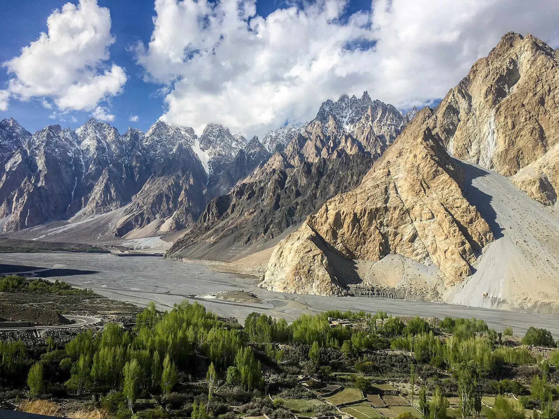
Photo: Mehrunisa Reimoo, with thanks · CC BY-SA 4.0 · via Wikimedia Commons · temporary stand-in photo

Gojal and Shimshal
Upper Hunza: Gulmit, Ghulkin, Passu and Sost on the Karakoram Highway, with big glaciers and the Passu Cones, plus the remote Shimshal valley, its Wakhi village and its mountaineering community.
Overview
Gojal, also called Upper Hunza, is the northern end of the Hunza valley, running from Shishkat and Gulmit up to Sost and the Khunjerab Pass on the Chinese border. It is the largest sub-division of Gilgit-Baltistan by area. Most of its villages sit on or near the Karakoram Highway (KKH), with the big glaciers of Ghulkin, Passu and Batura coming down to the valley floor. The people are mainly Wakhi, descendants of settlers from the Wakhan, and most are Ismaili Muslims. Kyrgyz nomads used upper Gojal as winter pasture before the Wakhi arrived. The area later came under the Mirs of Hunza. Valley floors start at about 2,438 m, so the air is thin and cold at night even in summer.
Three side valleys leave the KKH: Shimshal to the east, Chapursan to the north-west (see its own page), and Misgar near Sost. Shimshal is the largest valley in Hunza, with its village at about 3,100 m, the highest settlement in the district.
Plan your visit
- Nearest town
- Gulmit
- Getting there
From Gilgit, Gulmit is about 130 km, Passu about 145 km and Sost about 185 km on the Karakoram Highway (OSRM models 1 h 40 to 2 h 20; allow 4 to 5 hours to Passu). More
Best months
May – Oct
- Gojal and Shimshal
- Related places nearby: Hunza Valley, Attabad Lake, Borith Lake, Khunjerab National Park, Chapursan Valley, Misgar Valley, Khurdopin Glacier (Shimshal), Virjerab Glacier (Shimshal), Yazghil Glacier (Shimshal), Yukshin Gardan Glacier (Shimshal), Momhil Glacier, Shimshal Pamir
Getting there
From Gilgit, Gulmit is about 130 km, Passu about 145 km and Sost about 185 km by OSRM, modelled at 1 hour 40 to 2 hours 20; with real conditions allow four to five hours to Passu. The official tourism sheet gives 50 km from Aliabad to Passu (about 1 hour 10 minutes) and 45 km to Borith Lake (1 hour). Shared vans and buses on the KKH stop at the main villages.
To Shimshal. A 4x4 track branches off the KKH about 5 km north of Passu and climbs about 55 to 59 km up the Shimshal River gorge to the village. It opened in October 2003. OSRM models about 1 hour 40, but travellers report 2.5 to 4 hours because the road is narrow, exposed and subject to rockfall and washouts. Jeeps run from Passu and Gulmit, usually arranged the day before. Wikivoyage says foreigners should sign in with the police at the start of the road, after the suspension bridge over the Hunza River. In winter the road may be snowed up or damaged; check before you set out.
Villages and sights
Villages are listed here from south to north along the Karakoram Highway. Shishkat and Ainabad are the first Gojal villages reached from Aliabad. Gulmit follows, then Ghulkin, Hussaini, Passu, Gircha and Sost.
- Gulmit (about 2,465 m). The capital of Upper Hunza, with a small museum and walking routes.
- Ghulkin and Hussaini. Villages near the Ghulkin Glacier, with the wooden Hussaini suspension bridge across the Hunza River; it is a famous and rickety walkway, so cross with care.
- Passu. A village, about 125 km from Gilgit by one count, below the Passu Cones (Tupopdan, 6,106 m), among the most photographed peaks in Pakistan. The Passu Glacier ends close to the village and the Batura Glacier, about 57 km long (Wikipedia; other sources give 56 to 65 km), lies just north.
- Borith Lake (about 2,600 m). A shallow lake near Hussaini, popular for bird-watching and a short walk. A road leads up from Hussaini to a viewpoint, with a campground by the lake; swimming is possible in summer.
- Gircha. A village in the upper valley with the area's oldest mosque and first school, according to Wikipedia. A flood from the Dilboy side valley eroded part of its old village and fort.
- Sost. The border town, with customs and immigration for the route to China and the Khunjerab National Park beyond.
- Shimshal. Four hamlets (Farmanabad, Aminabad, Centre Shimshal and Khizarabad) and about 3,000 people. Shimshalis are known as a valley of mountaineers: many Pakistani high-altitude porters and climbers come from here. The Lok Versa Museum shows local life, and in late July or early August villagers hold a festival at Shimshal Pass with a yak race, music and dance.
- Shimshal Pass (4,735 m). The high pass above the village, on the old route towards the Shaksgam valley.
Treks and walks
Day walks from Passu and Gulmit include glacier viewpoints and the hanging bridges. Passu is small enough to explore on foot. A footpath reaches a suspension bridge over the Hunza River from the first hairpin south of the village, and a loop can be made by crossing the Hussaini bridge further downstream. The Yunz valley lies between the Passu and Batura glaciers behind Zard Sar; its trail is marked by cairns. Avgarch, near Khunjerab, is about 1.5 hours' walk from the KKH from Murkhun and has pastures, old watchtowers and snow leopard and ibex habitat (Wikipedia). Local guides can lead longer hikes. The Patundas route crosses the Passu Glacier. The Batura Glacier trek starts near Passu. Shimshal village is the start of the Shimshal Pamir and other high-pasture treks, some of which are in restricted areas. For a roundup, see Other treks in Gojal.
Landscape and history in brief
The Hunza River runs through Gojal in wide meanders, and several landslides have reshaped the valley. A slide in the late 1800s near Sarat village blocked the river and flooded fields and orchards in Gulmit, Hussaini and Passu. On 4 January 2010 another slide at Attabad blocked the gorge. The lake it created stretched about 24 km at its peak, from the barrier to Passu, and covered parts of Shishkat, Ayeenabad and Gulmit. See Attabad Lake for the present road and boats.
Gojal is also the western edge of the Karakoram and the Eastern Pamir. Of the glaciers, Batura is about 57 km long; others include Passu, Ghulkin, Hussaini, Yazghil and Khurdopin.
When to go
May to October is the main season. July and August bring the warmest weather and the highest chance of landslides; October brings autumn colour. Shimshal's high pastures are best from June to September. Winter is cold and the Shimshal road is hard to use.
Where to stay and eat
Gulmit, Passu and Ghulkin have guest houses and small hotels, and Shimshal village has guest houses and homestays (check what is open; options change). Meals are simple: bread, soups, potatoes, dried fruits and dairy, and most guest houses serve food. Passu has a general store; supplies thin out beyond the KKH villages. Order food in advance in Shimshal and bring spare cash; there are no banks in the side valleys.
Culture and languages
Wakhi (also called Xikwor) is the main language in Gojal and Shimshal and most local poets write in it. Burushaski is spoken in Shishkat, Nazimabad and the Raminj villages of Chapursan, and Urdu and English are widely understood. Gojal has about 20,000 Ismaili residents, and Gulmit has six Jama'at Khanas (prayer houses). Weddings in the villages include traditional dancing and food; ask locally before attending. The community follows the Ismaili tradition, and Shimshal is known for its self-help development projects and for the Shimshal Nature Trust, a community body that looks after the grazing lands. Respect local rules on camping and wildlife.
Safety and practical points
- Landslides on the KKH and the Shimshal road are the main danger, especially in July and August.
- Altitude affects some visitors above Gulmit; Shimshal is at about 3,100 m, so allow a day to adjust.
- Border areas are close. Foreign visitors have not needed an NOC for Gilgit-Baltistan since March 2019, but strips along the borders are restricted, so stay on the roads and tracks your operator has cleared.
- For trekking permits, ask a licensed operator and GB Tourism about current rules and fees; fees were reported to have risen in 2025, and Dawn (1 February 2026) reported that no foreign trekking or expedition group had been issued a winter permit in Gilgit-Baltistan since 2023.
Highlights
- The Passu Cones (6,106 m) and Passu and Ghulkin glaciers
- Hussaini suspension bridge and Borith Lake
- Batura Glacier, about 56 km long
- Shimshal village at about 3,100 m, home of many Pakistani mountaineers
- Yak race festival at Shimshal Pass in late July or early August
Tips
- Arrange jeeps for Shimshal the day before; allow at least three hours each way.
- Sign in with the police at the start of the Shimshal road if you are a foreign visitor.
- Carry cash; there are no banks in Shimshal.
- Spend a night at Gulmit or Passu before going higher.
- Ask your operator for current permit rules before any trek.
Photos we still need: Sost town and border customs area for this page; Batura Glacier snout from the KKH (current photo is reused on several pages). Send us yours
Sources and last checked
Last checked Confidence medium12 sources5 still to check
- Last checked
- Method
- Desk research from published sources
- Confidence
- medium
- Checked by
- trek.pk research team
Researched from published sources; not yet checked on the ground by our team. Spot something out of date? Report a mistake.
Sources
- Land of Culture: District Hunza tourist guide sheet · Tourism & Culture Department, Gilgit-Baltistan · checked
- Pakistan Tourism Guide 2021 · Trade Development Authority of Pakistan (TDAP) · checked
- Gojal (Wikipedia) · Wikipedia · checked
- Shimshal (Wikipedia) · Wikipedia · checked
- Passu Cones (Wikipedia) · Wikipedia · checked
- Gulmit (Wikipedia) · Wikipedia · checked
- Shimshal (travel guide) · Wikivoyage · checked
- OSRM driving routes (distances and modelled times between towns) · OSRM / OpenStreetMap · checked
- NOC requirements for foreigners visiting Pakistan abolished (26 March 2019) · Dawn · checked
- GB winter adventure tourism hit by soaring permit fee, visa delays (1 Feb 2026) · Dawn · checked
- Batura Glacier · Wikipedia · checked
- Passu · Wikivoyage · checked
Still to be checked on the ground (5)
- Shimshal road length and real driving time (55 km Wikivoyage, 56 km Wikipedia, 59 km elsewhere; Wikivoyage says about 2.5 hours by daily 4x4, travellers report up to 4)
- Whether foreigners need any permit beyond the police sign-in for Shimshal village (Wikivoyage: police sign-in only; no official source)
- Batura Glacier length (Wikipedia 57 km; another source about 65 km)
- Winter condition and closure of the Shimshal road (no source; on the ground)
- Hussaini bridge and Passu footbridge condition and any closures (Wikivoyage only)
Nearby and related

Patundas

Batura Glacier

Shimshal Village

Shimshal Pamir

Other treks in Gojal

Kilik and Mintaka Passes

Hunza Valley
A long Karakoram valley on the Karakoram Highway, with Karimabad, Baltit and Altit forts, Ganish village and Attabad Lake, below Rakaposhi and Ultar Sar. About 100 km from Gilgit.

Attabad Lake
A turquoise lake about 21 km long in Gojal, Hunza. It formed when a landslide blocked the Hunza River on 4 January 2010. The Karakoram Highway now passes it through five tunnels.

Borith Lake
A small lake in Gojal, upper Hunza, a short walk from Hussaini and Gulmit. It lies at about 2,600 m, fed by meltwater from Hussaini Glacier, and is a resting stop for migrating wildfowl.

Khunjerab National Park
A high-altitude park on the Pakistan-China border, created in 1975 to protect Marco Polo sheep, snow leopard and Himalayan ibex. It surrounds the Khunjerab Pass on the Karakoram Highway.

Chapursan Valley
A high Wakhi valley running west from Sost to the Afghan border, with villages above 3,000 m, the Baba Ghundi shrine, glaciers and remote passes. Reached by a rough jeep road.
Misgar Valley
The northernmost inhabited valley of Hunza, near the Chinese border. Base for the Kilik and Mintaka passes and home to Qalandarchi Fort.

Khurdopin Glacier (Shimshal)
A surging glacier above Shimshal. A 2017 surge dammed the river and formed a lake that drained in July and August, cutting the valley off for about a week.
Virjerab Glacier (Shimshal)
A glacier of the Shimshal region. Its name is spelled several ways (Virjerab, Vijerab, Virzherav). Sources are thin; no access directions are given here.
Yazghil Glacier (Shimshal)
A large glacier a few hours' walk up the Shimshal valley, with shepherds' huts. It is seen from the Gar-e-Sar viewpoint and crossed on the way to Kanjut Sar Base Camp.
Yukshin Gardan Glacier (Shimshal)
A glacier beyond the Yazghil Glacier on the way to Kanjut Sar Base Camp, below Yukshin Gardan Sar. Sources are thin.
Momhil Glacier
The glacier below Momhil Sar (7,414 m) in the Hispar Muztagh. The Momhil Sar Base Camp trek starts at the Momhil bridge beyond Dut. Sources are thin.

Shimshal Pamir
The high summer pastures above Shimshal village at about 4,350 to 4,700 m, grazed by yaks, sheep and goats, with two lakes and Shimshal Pass (4,735 m) at the upper edge. Reached on foot only.

Hunza and Khunjerab (KKH)
A 7-8 day road trip from Islamabad up the Karakoram Highway to Hunza and on to Khunjerab Pass (4,693 m), with overnight stops at Besham, Chilas and Gilgit.

Islamabad to Khunjerab and the China Border
An overland guide from Islamabad to Khunjerab Pass (4,693 m) on the KKH, with the border rules to check: who can visit the top, who can cross to China, and the seasons.