

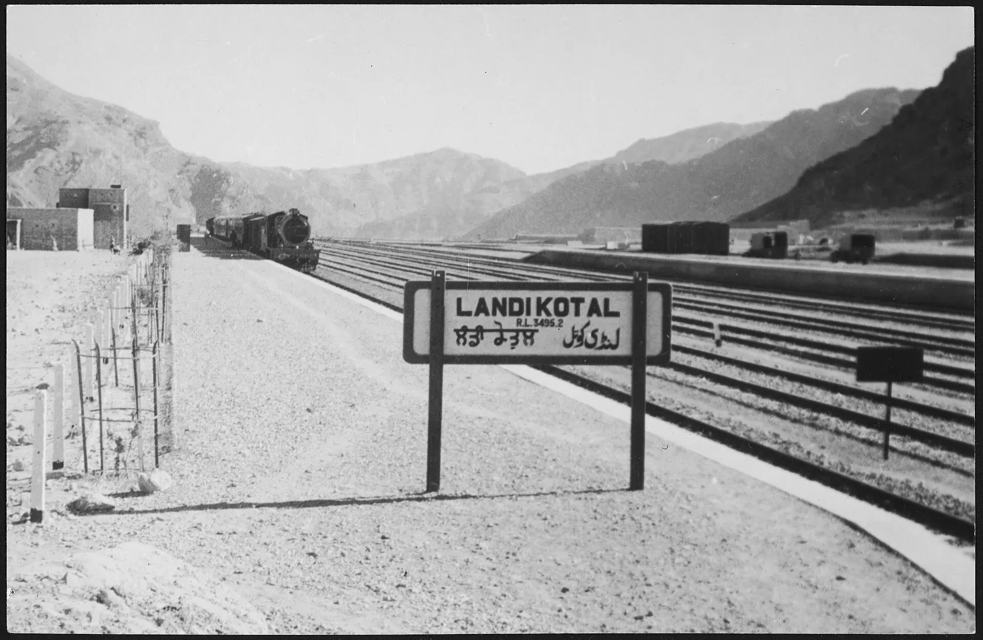
Photo: Landi Kotal railway station, with thanks · Public domain (CC0) · via Wikimedia Commons · temporary stand-in photo

Landi Kotal
Hill town at the western end of the Khyber Pass, 1,072 m above sea level and about 5 km from the Afghan border. For foreign visitors: the UK FCDO advises against all travel to Khyber.
Overview
Landi Kotal is a town in Khyber Pakhtunkhwa and the administrative capital of Khyber District. It stands at about 1,072 m at the western end of the Khyber Pass, on the route over the mountains from the Peshawar valley. Its Pashto name is Lwargai. The Afghan border at Nangarhar Province lies about 5 km to the west.
The 2023 census counted 38,065 people (Wikipedia). The town has grown quickly: Wikipedia lists 1,695 in 1961, 22,324 in 1998 and 33,697 in 2017. It was one of the larger towns of the former tribal areas.
Plan your visit
- Getting there
Road: Peshawar is about 46 km and roughly 55 minutes by road (OSRM, checked 16 November 2026), but Peshawar and Khyber are both on the FCDO advise-against list. Rail: the old Khyber Pass Railway has not run since 2006. More
Best months
Mar – Apr, Oct – Dec
- Landi Kotal
- Related places nearby: Peshawar, Shagai Fort
History
Landi Kotal sits where armies, caravans and traders have long crossed the mountains. During the Second Anglo-Afghan War it was the camp of the 12,000-strong Peshawar Valley Field Force under Sir Samuel Browne. In 1897 the Afridis overran the town after the Khyber Rifles ran short of water. The British then sent about 34,500 men under Sir William Lockhart to retake the area. The British-era fort had a keep and an outer fort and held five British officers and about 500 local officers and men. From 1899 the Khyber Rifles, a tribal militia, garrisoned it.
The Khyber Pass
The pass itself runs about 40 km from Jamrud to Landi Kotal, and the road climbs about 460 m on the way. Wikipedia lists a long line of invaders and rulers who used it, from Persian kings and nomad confederations to Mahmud of Ghazni, Babur and Nader Shah. Afridi and Shinwari clans have lived along it and once charged travellers for safe passage. Sikh forces took the pass in 1837, and Hari Singh Nalwa built Jamrud Fort at its mouth. See Khyber Pass, Bab-e-Khyber, Jamrud Fort and Ali Masjid Fort.
Khyber Pass Railway
The British built the Khyber Pass Railway after the First World War. It opened in 1925 and ran from Jamrud to Landi Kotal, where it ended. A tourist steam train, the Khyber train safari, ran on it until 2006, when floods washed out the track and bridges. Our Khyber Pass Railway route covers the line, and Shagai Fort stands on it.
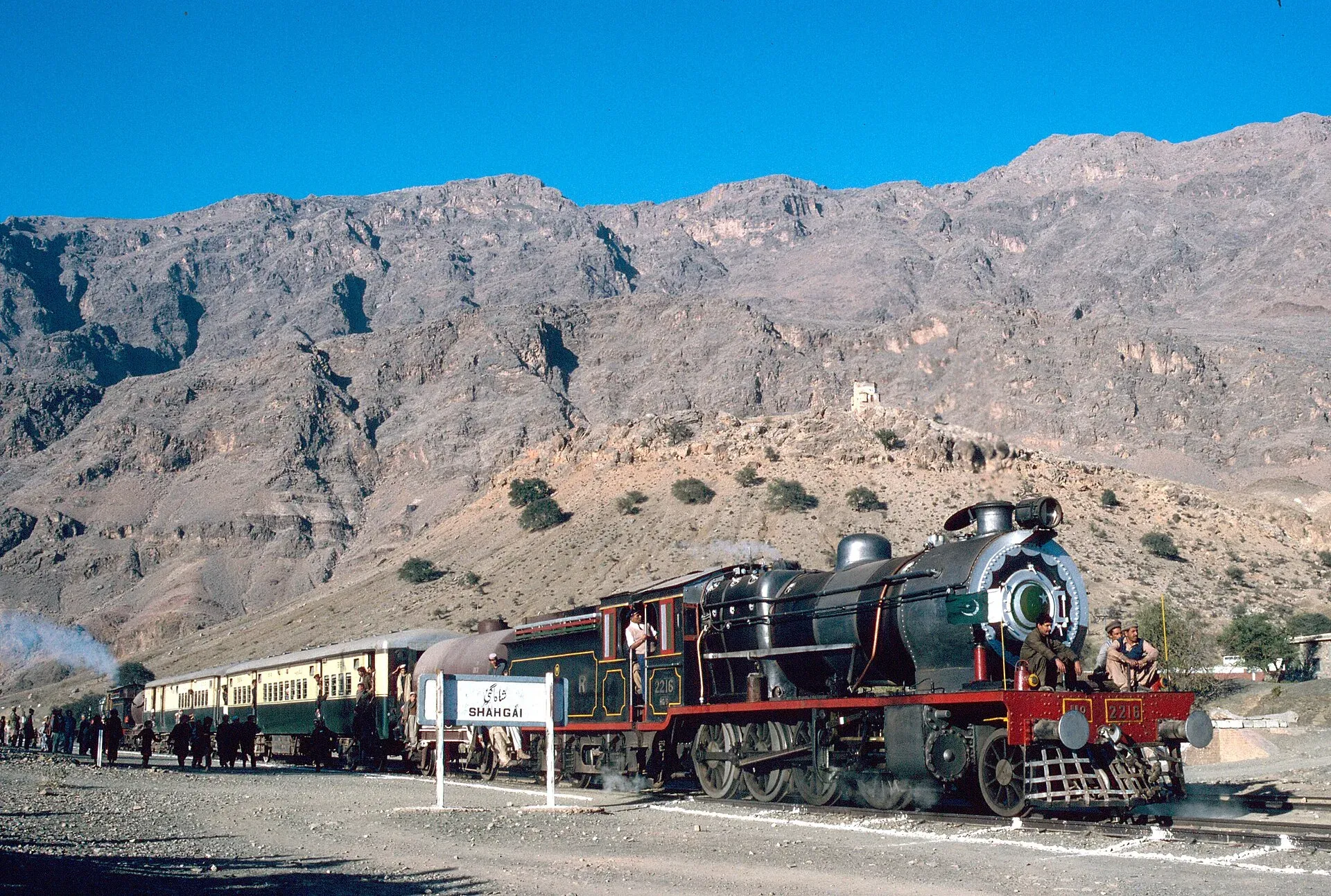
Photo: MaltaGC, with thanks · CC BY-SA 3.0 · via Wikimedia Commons · temporary stand-in photo

Market and people
Wikipedia calls Landi Kotal the main shopping centre for the Shalmani, Shinwari, Afridi and Mulagori tribes of the Khyber area. It is a trading and transit town rather than a visitor destination.
What to see and do
The famous draw is the Khyber Pass itself, which links the town to the Peshawar valley. Wikipedia also notes an old banyan tree that was ceremonially placed under arrest by a British officer in 1898, with a board that still stands.
When to visit
Check conditions and the security situation first.
Where to stay and eat
We have no verified visitor facilities. The town is a trading and transit stop.
Good to know
Safety: For foreign visitors: the UK FCDO Pakistan page (updated 27 October 2026, checked 17 November 2026) advises against all travel to Khyber District and within 10 miles of the Pakistan-Afghanistan border. It also notes emergency measures in Khyber Pakhtunkhwa. We do not recommend planning a trip to Landi Kotal.
Highlights
- Western end of the Khyber Pass
- About 1,072 m above sea level
- Old Khyber Pass Railway terminus
- Administrative capital of Khyber District
Getting there
Road: Peshawar is about 46 km and roughly 55 minutes by road (OSRM, checked 16 November 2026), but Peshawar and Khyber are both on the FCDO advise-against list. Rail: the old Khyber Pass Railway has not run since 2006. Air: Peshawar.
Hotels, food, fuel and services in Landi Kotal
Places to eat
- Mumtaz Bakers & SweetsMap of Mumtaz Bakers & Sweets in Google Maps
- Madina BakeryMap of Madina Bakery in Google Maps
Essential services fuel stations, pharmacies and hospitals and clinics
Fuel
- PSO Torkham Filling StationMap of PSO Torkham Filling Station in Google Maps
- Pakhtoonkhwa Filling Station Landi KotalCall Pakhtoonkhwa Filling Station Landi KotalMap of Pakhtoonkhwa Filling Station Landi Kotal in Google Maps
- Shell Gasoline Station Landikotal PakistanMap of Shell Gasoline Station Landikotal Pakistan in Google Maps
- Kam Shelman Petrol StationCall Kam Shelman Petrol StationMap of Kam Shelman Petrol Station in Google Maps
- Sultan khel filling stationCall Sultan khel filling stationMap of Sultan khel filling station in Google Maps
- Haji Zubair petrol stationMap of Haji Zubair petrol station in Google Maps
Pharmacies
- Saif Shinwari medicoseCall Saif Shinwari medicoseMap of Saif Shinwari medicose in Google Maps
Hospitals and clinics
- Dr.Taza Gul Khan AfridiMap of Dr.Taza Gul Khan Afridi in Google Maps
Listings come from Google Maps data and are unverified: phone numbers, opening months and prices may have changed. Report a problem · Own one of these? Claim it
Tips
- Do not plan a visit without reading the FCDO page first.
- Border-area checkpoints are strict.
- If you go, travel only with proper permission and local guidance.
- The Khyber train safari no longer runs.
Photos we still need: Landi Kotal bazaar or the 'arrested' banyan tree (not photographable now without a field visit). Send us yours
Sources and last checked
Last checked Confidence low4 sources4 still to check
- Last checked
- Method
- Desk research from published sources
- Confidence
- low
- Checked by
- trek.pk research team
Researched from published sources; not yet checked on the ground by our team. Spot something out of date? Report a mistake.
Sources
- Landi Kotal · Wikipedia · checked
- OSRM driving routes (road distances and times, optimistic) · Project OSRM · checked
- Pakistan travel advice: warnings and insurance · UK FCDO (GOV.UK) · checked
- Khyber Pass · Wikipedia · checked
Still to be checked on the ground (4)
- Current security and access (FCDO, 27 October 2026, advises against all travel to Khyber District, Peshawar and within 10 miles of the Afghan border; ground conditions not checkable)
- Visitor facilities (Wikipedia does not cover them)
- Khyber Pass access rules (no official source found; Wikipedia's Khyber Pass article has only dated closure notes)
- Licence status of the Schwarzenbach hero photo should be re-confirmed on Commons
Nearby and related

Peshawar
Khyber Pakhtunkhwa's capital and one of South Asia's oldest living cities: the Gandhara museum, Qissa Khwani Bazaar, mosques and a strong food culture.
Shagai Fort
A British-built frontier fort of 1927 above the Khyber Pass, now an army post run by the Khyber Rifles. Not open to the public; FCDO advises against all travel to Khyber district.