

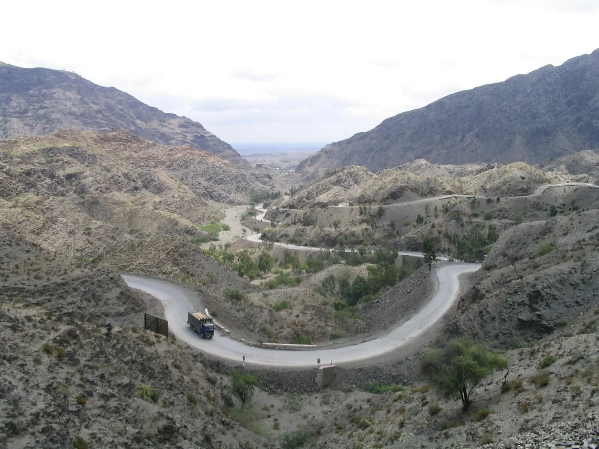
Photo: James Mollison, with thanks · CC BY-SA 2.5 · via Wikimedia Commons · temporary stand-in photo

Khyber Pass
The historic 40 km pass from Jamrud to Landi Kotal and the Afghan border, used by invaders and traders for thousands of years. Today the area is under an FCDO all-travel warning and Torkham is closed.
Overview
The Khyber Pass is the best known mountain pass in South Asia. It runs through the Safed Koh (Spin Ghar) range for about 40 km, from Jamrud near Peshawar to Landi Kotal, with a further 13 km to Loya Daka in Afghanistan. The pass starts at Kadam near Jamrud, about 18 km west of Peshawar. The summit at Landi Kotal lies 5 km inside Pakistan and about 460 m above the Peshawar valley floor. Its height is given as 1,070 m in one place and 1,028 m in another, so treat it as about 1,030 to 1,070 m.
It links the Peshawar plain with Kabul and Central Asia. The N-5 highway (part of Asian Highway 1 and the old Grand Trunk Road) follows it, as did a railway. Afridi clans live in the villages along the pass, with the Shalmani and Mullagori to the north and Afridi Tirah to the south. These Pashtun clans have long regarded the pass as their own and levied tolls on travellers for safe passage.
Please note: this page is a history and background guide. It is not a place we can recommend you visit now. See "Good to know".
Plan your visit
- Nearest town
- Landi Kotal (Jamrud at the Peshawar end)
- Getting there
The pass starts at Jamrud, about 18 km west of Peshawar, and the N-5 runs through it to Landi Kotal and Torkham. We do not recommend travel here at present; check the FCDO advice and local authorities. More
- Khyber Pass
- Related places nearby: Landi Kotal, Peshawar, Khyber Pakhtunkhwa, Shagai Fort, Jamrud Fort (Fatehgarh), Khyber, Ali Masjid Fort, Bazar Caves
History
The pass was not a widely used trade route before the Kushan era. It then became part of the Silk Road, and Gandhara grew rich as a link between Bagram in Afghanistan and Taxila, adding ivory, pepper and textiles from India to the Silk Road trade. Greek influence travelled into India and Buddhism travelled out through it.
Armies crossed it for centuries. They included the Persians under Darius I, Mahmud of Ghazni, Muhammad of Ghor, Timur, Babur and Nader Shah. Ahmad Shah Durrani is called the last major conqueror to use it. In 1837 the Sikh army under Ranjit Singh took the pass, and Hari Singh Nalwa built Jamrud Fort. After the Second Anglo-Afghan War the British controlled it from 1880 and paid local tribes to keep it safe.
The British Indian government built the Khyber Pass Railway after the First World War. It opened in 1925, from Jamrud to the Afghan border near Landi Kotal. Wikipedia describes the line as closed today, apart from the Khyber Steam Safari of the 1990s. In the Second World War, concrete "dragon's teeth" were placed on the valley floor against a feared invasion. A common colonial saying measured British India as "Khyber to Kanyakumari".
After 1947 the pass became part of Pakistan. It was a stretch of the overland hippie trail between Kabul and Peshawar. From 2001, it carried much of the NATO supply traffic into Afghanistan; Wikipedia gives almost 80 percent of road supplies. Pakistan closed it more than once in 2009, 2010 and 2011 for security reasons. The area around the pass is also known among gun collectors for the hand-made weapons called "Khyber Pass copies".
What to see and do
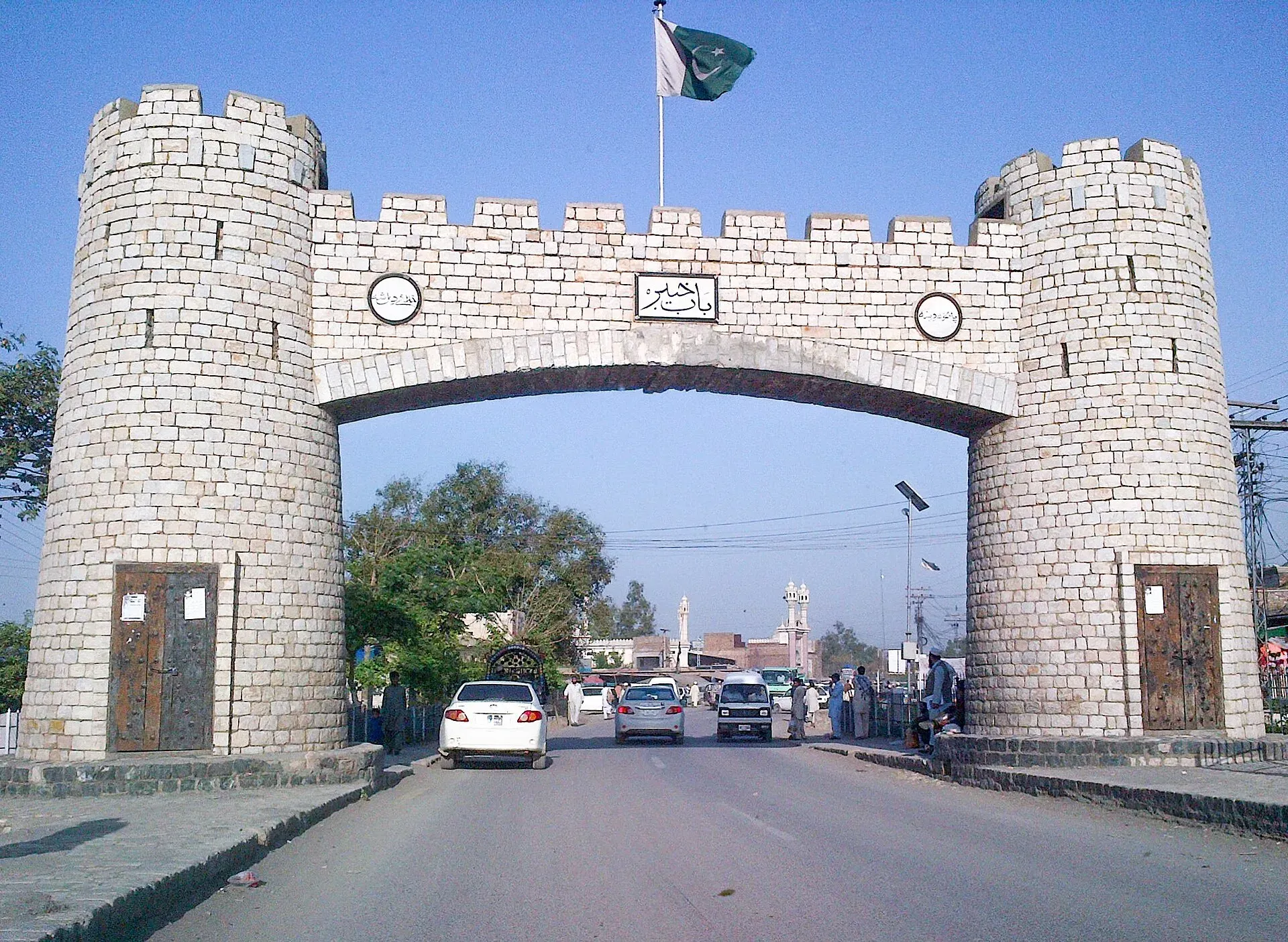
Photo: Muhammad Imran Saeed, with thanks · CC BY 2.5 · via Wikimedia Commons · temporary stand-in photo

Historically the pass matters more than the scenery. The sites below are listed from Peshawar to the border, for background only.
- Bab-e-Khyber: the gate at the Peshawar end of the pass, next to Jamrud Fort.
- Jamrud Fort: the fort built by the Sikh general Hari Singh Nalwa in the 1830s to guard the pass.
- Ali Masjid Fort: a hill fort in a narrow gorge in the middle section of the road.
- Landi Kotal: the town at the summit, about 5 km from the border. A travel guide says the Khyber Rifles Museum is inside Landi Kotal Fort.
- Torkham: the border crossing. See "Good to know".
Monuments left by British Indian Army units and hillside forts could be seen from the road in earlier decades.
When to visit
We cannot suggest a season, because ordinary visits are not advised. Our Landi Kotal page lists autumn and spring as the milder months for the town.
Good to know
- Ask the district administration or local police about current conditions before you go. Travel advice. For foreign visitors: the UK FCDO (updated 27 October 2026, checked 16 November 2026) advises against all travel to Khyber district and Peshawar, and against all travel within 10 miles of the Pakistan-Afghanistan border. Landi Kotal is about 5 km from the border.
- Border. RFE/RL reported on 4 October 2026 that Torkham and the other major crossings had stayed closed since Pakistan shut them on 12 October 2025 after clashes with Afghanistan. The report gave no reopening date, for trade or for travellers.
- Permission. There is no known current official rule that lets tourists drive the pass. One travel guide says a permit and an armed escort are required from Peshawar to Torkham. Do not try without written permission from the district administration.
- Fees. Not applicable. No tourist charge is confirmed.
- Lodging. There is no tourist lodging in the pass; Peshawar is the nearest base.
Highlights
- About 40 km from Jamrud to Landi Kotal
- Used by invaders and traders since ancient times
- Khyber Pass Railway opened in 1925
- Under an FCDO all-travel warning today
Getting there
The pass starts at Jamrud, about 18 km west of Peshawar, and the N-5 runs through it to Landi Kotal and Torkham. We do not recommend travel here at present; check the FCDO advice and local authorities.
Tips
- Treat this as a history page, not a trip plan
- Read the live FCDO page and ask the district administration about permission
- Do not travel to Torkham: the crossing has been closed since October 2025
- Peshawar museum and Bala Hisar give the story from a safe distance
Sources and last checked
Last checked Confidence medium5 sources4 still to check
- Last checked
- Method
- Desk research from published sources
- Confidence
- medium
- Checked by
- trek.pk research team
Researched from published sources; not yet checked on the ground by our team. Spot something out of date? Report a mistake.
Sources
- Khyber Pass (Wikipedia) · Wikipedia · checked
- Afghanistan-Pakistan border closure, one year on (4 October 2026) · RFE/RL · checked
- Pakistan Tourism Guide 2021 · TDAP Pakistan · checked
- Pakistan travel advice: warnings and insurance (updated 27 October 2026) · UK FCDO · checked
- Khyber Pass (Wikivoyage) · Wikivoyage · checked
Still to be checked on the ground (4)
- Summit height: Wikipedia gives 1,070 m (infobox) and 1,028 m (text, citing Hari Ram Gupta); no official figure found
- Torkham status after 4 October 2026 (still closed in the latest report we opened)
- Official permission rules for entering the pass (Wikipedia and RFE/RL give none)
- Permit and escort rules between Peshawar and Torkham (one travel guide mentions both; no official source found)
Nearby and related

Landi Kotal
Hill town at the western end of the Khyber Pass, 1,072 m above sea level and about 5 km from the Afghan border. For foreign visitors: the UK FCDO advises against all travel to Khyber.

Peshawar
Khyber Pakhtunkhwa's capital and one of South Asia's oldest living cities: the Gandhara museum, Qissa Khwani Bazaar, mosques and a strong food culture.

Khyber Pakhtunkhwa
Mountains, Buddhist ruins and old bazaars in north-west Pakistan: Swat, Kaghan, Chitral, the Kalash valleys, the Khyber Pass and Peshawar.

Attock
District capital on the Grand Trunk Road near the Indus, about 86 km from Islamabad. A practical stop with the Mughal-era Attock Fort nearby.
Shagai Fort
A British-built frontier fort of 1927 above the Khyber Pass, now an army post run by the Khyber Rifles. Not open to the public; FCDO advises against all travel to Khyber district.
Jamrud Fort (Fatehgarh), Khyber
A Sikh-era frontier fort of 1836 to 1837 at the eastern end of the Khyber Pass, beside Bab-e-Khyber. Hari Singh Nalwa died here in 1837. It is a military site, not open to the public. FCDO advises against all travel to Khyber.
Ali Masjid Fort
A fort above the narrowest point of the Khyber Pass, built in 1837 under Dost Muhammad Khan and twice taken by the British. In Khyber district, where the UK FCDO advises against all travel.
Bazar Caves
A group of caves in the hills of Khyber district, Khyber Pakhtunkhwa. Little is documented. For foreign visitors: the UK FCDO advises against all travel to Khyber district, so this page is for information only.

Mughal Lahore and the Grand Trunk Road
A four-day journey from Lahore's Mughal monuments up the Grand Trunk Road to Rohtas Fort. History from Akbar to Aurangzeb, OSRM-measured day plan and current safety notes.