

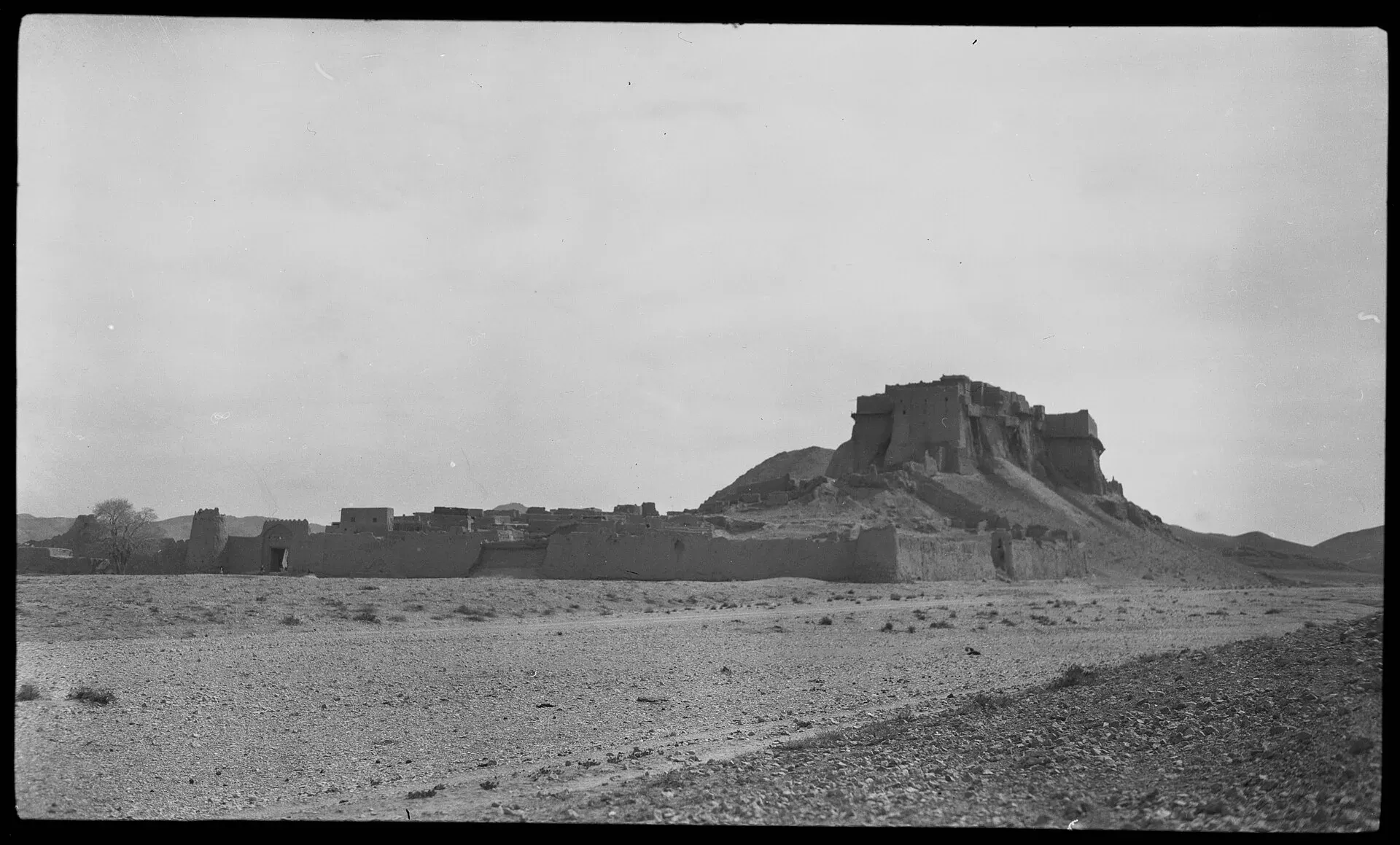
Photo: Georg Morgenstierne, with thanks · Public domain (CC0) · via Wikimedia Commons · temporary stand-in photo

Miri Fort (Kalat)
The old fortified seat of the Khans of Kalat, on the hills above Kalat town in central Balochistan. Little of it stands, and public information is thin. Not to be confused with the Miri (Sassi Punnu) fort near Turbat.
Overview
Miri (also written Meeri) is the name of the old citadel and royal residence of the Khans of Kalat, on high ground above Kalat town in the Central Brahui hills of Balochistan. Kalat stands at about 2,007 m and was the capital of the Khanate of Kalat from the 17th century to the mid-20th century. The Miri was the centre of that power. The fort is now mostly ruined, and little recent information is published, so this page is an orientation rather than a visitor guide.
Which Miri? There is another, much older Miri: Miri Qalat, the Sassi Punnu fort, on the right bank of the Kech River about 6 km north-west of Turbat. It is a separate site, also ruined, linked to the Sassi-Punnu love story and to a long line of tribal rulers, and excavated by French missions. It is not the fort described here.
Plan your visit
- Nearest town
- Kalat
- Getting there
Kalat is about 142 km (about 1 hour 45 minutes) by road from Quetta (OSRM, checked 16 November 2026). The fort is on high ground above the town. More
Best months
Mar – May, Sep – Oct
History
- Before the 15th century. Kalat was known as Kalat-e Sewa and was ruled by the Hindu Sewa dynasty. A Hindu temple dedicated to Kali stands at the foot of the old city fort.
- 15th to 17th centuries. The Brahui Mirwari clan took the town and built a large kingdom. The Khans of Kalat were dominant from the 17th century.
- Mir Nasir Khan I (ruled from about 1749 to 1794). Widely seen as the greatest Khan; the state reached its widest extent under him. One regional account says the royal castle Miri, where the Khan lived, was known in his time as "Kalat-e-Nasseer". The date of building and the builder are not recorded in the published sources.
- 1758. Ahmad Shah Durrani's army tried to take the fort at Kalat by storm and failed.
- 1839. British forces took and sacked Kalat on 13 November 1839.
- 1876. A treaty brought Kalat under the British Empire.
- 1935. The great earthquake of 1935 badly damaged the old fort, according to writer Salman Rashid, and only a vestige remains. The ruling Khan, Mir Ahmed Yar Khan, then had a new palace built in the meadows and orchards east of the town.
- 1948 and 1955. The Khanate acceded to Pakistan on 27 March 1948. The Khan was formally removed from power in 1955.
The citadel above the town
A 1908 description calls the miri an imposing structure commanding the town, where the Khan lived. A photograph from the Morgenstierne collection (shown above) shows the town from the north-west, surrounded by a wall with bastions at intervals, with the miri on the height above. No published description gives the size, layout or present condition of what survives. The ruined walls on the hill and the town below are the main things to look for.
The Art Deco palace
The palace built after the earthquake is a separate building and stands in a different part of the town. One account describes it as Art Deco in style, built by a Punjabi craftsman, reportedly a Sikh, who had learned his trade through years of experience rather than formal training. Its stairs and plinth imitate the radiator grille and bonnet of an American car. The balcony railings follow Art Deco curves but carry the upturned crescent and star of the Kalat coat of arms. The facade is mirrored on each side and the curves run around the building without corners.
When to visit
Kalat has a cold desert climate. The average January temperature is about 3 degrees C and the average July temperature is about 25 degrees C. Annual rainfall is about 163 mm, with January the wettest month and June the driest. The record low is minus 17 degrees C (20 January 1978). Spring and autumn are the most comfortable seasons.
Where to stay and eat
Kalat is a small town with simple local eateries. Most visitors would base themselves in Quetta.
Good to know
- Kalat is in Balochistan. Ask the district administration or local police about current conditions before you go. For foreign visitors: the UK FCDO advises against all travel to Balochistan (updated 27 October 2026, checked 17 November 2026).
- No opening hours or fees are published. Current fees will be added soon; check with the Department of Archaeology and Museums, Government of Balochistan.
- This is a place of local and regional pride. Ask before you photograph people, and avoid political discussion.
- Related pages on this site: Kalat, Quetta and Khuzdar.
Highlights
- Old seat of the Khans of Kalat
- Held out against a Durrani assault in 1758
- Sacked by British forces in 1839
- Art Deco Khan's palace nearby
Getting there
Kalat is about 142 km (about 1 hour 45 minutes) by road from Quetta (OSRM, checked 16 November 2026). The fort is on high ground above the town. Confirm road conditions and any security restrictions locally before you set out.
Tips
- Check the Balochistan security situation before any plan.
- Do not confuse it with the Miri fort near Turbat.
- Ask locally before you climb the hill or photograph the area.
- Bring warm layers in winter.
Photos we still need: the surviving ruins of the Miri citadel at Kalat; the Art Deco palace of the Khan of Kalat. Send us yours
Sources and last checked
Last checked Confidence low6 sources4 still to check
- Last checked
- Method
- Desk research from published sources
- Confidence
- low
- Checked by
- trek.pk research team
Researched from published sources; not yet checked on the ground by our team. Spot something out of date? Report a mistake.
Sources
- Kalat, Balochistan · Wikipedia · checked
- Khanate of Kalat · Wikipedia · checked
- Art Deco rhapsody: Khan of Kalat's palace · Salman Rashid (blog) · checked
- The forgotten history of Miri Fort (Turbat, for contrast) · Folkloristan · checked
- OSRM driving route calculation · OSRM (OpenStreetMap routing) · checked
- Pakistan travel advice (warnings and insurance), updated 27 October 2026 · UK Foreign, Commonwealth & Development Office · checked
Still to be checked on the ground (4)
- Whether a fort called Miri still stands at Kalat and what remains (only a 1908 description and the 1935 earthquake account; no recent source)
- Build date and builder of the fort
- Whether any part is open to visitors
- The current security situation around Kalat (FCDO: all travel to Balochistan advised against)
Nearby and related

Quetta
Balochistan's high-valley capital, the Fruit Garden of Pakistan: bazaars, sajji, orchard valleys and the base for Hanna Lake and Ziarat.

Balochistan
Pakistan's largest and least populated province: Quetta's high valleys, Ziarat's juniper forest, the Makran coast, Hingol and Gwadar. Security and permission rules need checking first.

Khuzdar
The main city of central Balochistan, once the Jhalawan capital of the Khanate of Kalat, at about 1,237 m on the road between Quetta and Karachi.
Sassi Punnu Fort
An ancient mound and fort site on the Kech River, about 6 km north-west of Turbat in Makran. Excavated by a French mission in the 1990s; linked to the Sassui-Punnhu folk tale. In an area the UK FCDO advises against visiting.