

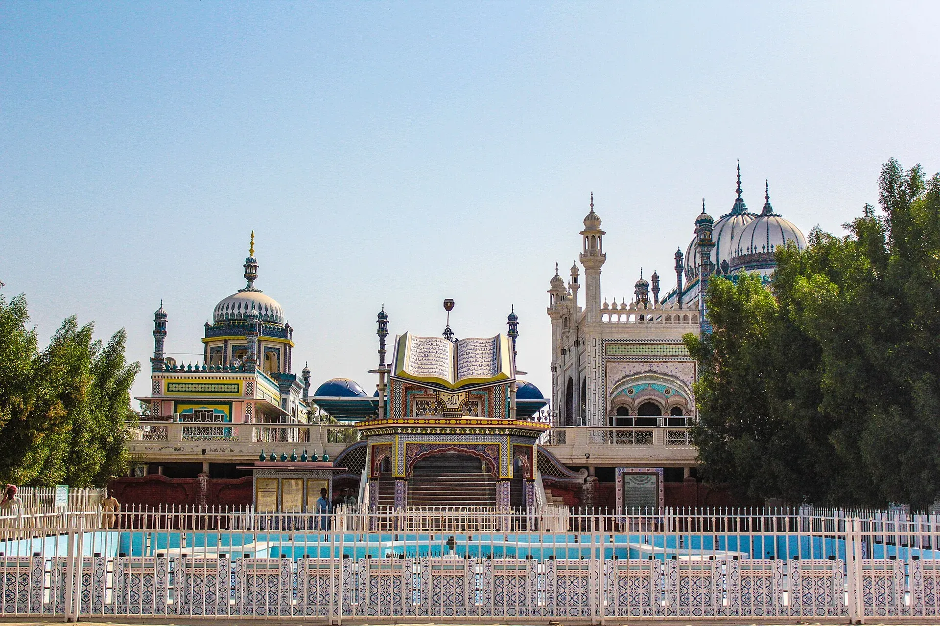
Photo: Tanzeel Uz Zaman Babar, with thanks · CC BY-SA 4.0 · via Wikimedia Commons · temporary stand-in photo

Rahim Yar Khan
District capital at the south-west tip of Punjab and a hub for sugar and mango growing. Gateway to the Cholistan desert and the Bahawalpur heritage sites.
Overview
Rahim Yar Khan is the capital of Rahim Yar Khan District, in the far south of Punjab near the Sindh border. It was founded in 1751 as Noshehra and renamed in 1881 after the son of Sadeq Mohammad Khan IV, the ruler of Bahawalpur. The town was part of Bahawalpur State until 1943, when it became a separate district.
The 2023 census counted 519,261 people (Wikipedia, citing the census). Most residents speak Punjabi (52.9 per cent) or Saraiki (32.9 per cent). The city stands on the eastern bank of the Indus, and about a quarter of it lies in the Cholistan desert.
Plan your visit
- Getting there
From Bahawalpur: about 194 km, roughly 2 hours 35 minutes (OSRM, optimistic, checked 16 November 2026). The city is on the M-5 motorway between Multan and Sukkur, and on the Karachi to Peshawar ML-1 railway main line; More
Best months
Oct – Mar
- Rahim Yar Khan
- Related place nearby: Sadiqabad
Farming and everyday life
Wikipedia calls it one of southern Punjab's leading farming and industrial centres: it says about 65 per cent of the population works in agriculture, with sugarcane, wheat, cotton and rice the main crops and many agro-based industries in the city. The district is known for mangoes, which are best in June and July. Educational institutions include Khawaja Fareed University of Engineering and Information Technology, a campus of the Islamia University of Bahawalpur and Khawaja Fareed Government College.
What to see and do
The town is a working commercial centre, and the main reason to come is the surrounding district.
- Bhong Mosque. In Bhong village, about 43 km from the city by road (OSRM estimate, about 50 minutes). Rais Ghazi Mohammad, a landowner, began it in 1932 as the showpiece of his palace compound, which also held a smaller mosque and a madrasa. It took nearly 50 years and was finished in 1982. Masons and craftsmen came from Rajasthan and calligraphers and painters from Karachi. The decoration draws on styles from Lahore, Iran, Spain and Turkey, and uses glazed tile, fresco, mirror work, marble, teak, gilded tracery and inlay. It won an Aga Khan Award for Architecture in the 1984-1986 cycle.
- Islamgarh Fort. Wikipedia names it among the local landmarks. See the Islamgarh Fort page.
- Pattan Minara. Wikipedia mentions this old brick tower about 8 km east of the centre, and calls it the remains of an ancient monastery. It gives both 5,000 years and the Mauryan period (250 BC) as its age, so the age is unreliable, and access has not been confirmed.
- The wider region. Cholistan and the heritage of the former Bahawalpur state lie to the north: Derawar Fort, Uch Sharif, Noor Mahal and Lal Suhanra National Park are all in or near Bahawalpur District. See Bahawalpur.
When to visit
October to March. Summers are very hot and dry. Mangoes ripen in June and July, if the season matters more than the heat.
Where to stay and eat
The town has several hotels of various grades and many restaurants serving grills and Saraiki dishes. No hotels or restaurants have been verified for this page. Bahawalpur has more heritage-style options.
Good to know
As a district headquarters the town should have a government hospital, pharmacies, banks with ATMs and fuel stations, but none has been verified, so check on arrival and fill up and withdraw cash before heading into the countryside.
Safety. The UK FCDO Pakistan page (updated 27 October 2026, checked 16 November 2026) advises against all but essential travel to Dera Ghazi Khan, the only Punjab area it lists, and against all but essential travel within 5 miles of the India border. Rahim Yar Khan is not named on the page, but it borders Sindh, where the FCDO advises against all but essential travel north of and including Nawabshah (the district borders Sindh's Ghotki area). Check the live page for the exact border area before travelling south or west.
Highlights
- Founded in 1751, renamed in 1881
- Mango, sugarcane and cotton country
- Edge of the Cholistan desert
- Gateway to Bahawalpur-region heritage
Getting there
From Bahawalpur: about 194 km, roughly 2 hours 35 minutes (OSRM, optimistic, checked 16 November 2026). The city is on the M-5 motorway between Multan and Sukkur, and on the Karachi to Peshawar ML-1 railway main line; check timetables with Pakistan Railways. It also has Shaikh Zayed International Airport; Wikipedia lists flights to Karachi, Lahore and Islamabad, but schedules change, so check current flights.
Hotels, food, fuel and services in Rahim Yar Khan
Places to stay
- Sadiq club residencyMap of Sadiq club residency in Google Maps
- Etihad ClubCall Etihad ClubMap of Etihad Club in Google Maps
- Doctor's HostelCall Doctor's HostelMap of Doctor's Hostel in Google Maps
- Al Saeed Boys Hostel Sheikh ZayedMap of Al Saeed Boys Hostel Sheikh Zayed in Google Maps
- Azmat Homestay ( Boys hostel )Call Azmat Homestay ( Boys hostel )Map of Azmat Homestay ( Boys hostel ) in Google Maps
- Usama Boys Hostel Rahim Yar KhanCall Usama Boys Hostel Rahim Yar KhanMap of Usama Boys Hostel Rahim Yar Khan in Google Maps
Places to eat
- Pizza TownMap of Pizza Town in Google Maps
- Bake HouseCall Bake HouseMap of Bake House in Google Maps
- Bonfire Pizza KitchenCall Bonfire Pizza KitchenMap of Bonfire Pizza Kitchen in Google Maps
- Dixy Chicken Rahim Yar KhanCall Dixy Chicken Rahim Yar KhanMap of Dixy Chicken Rahim Yar Khan in Google Maps
- SubwayCall SubwayMap of Subway in Google Maps
- Fine BakersCall Fine BakersMap of Fine Bakers in Google Maps
Essential services fuel stations, mechanics, ATMs, pharmacies, hospitals and clinics and Rescue 1122
Fuel
- Al-Sultan Filling Station- Total Petrol StationCall Al-Sultan Filling Station- Total Petrol StationMap of Al-Sultan Filling Station- Total Petrol Station in Google Maps
- PSO - United PetroleumCall PSO - United PetroleumMap of PSO - United Petroleum in Google Maps
- Rehman Petroleum (PSO Fuel Pump)Call Rehman Petroleum (PSO Fuel Pump)Map of Rehman Petroleum (PSO Fuel Pump) in Google Maps
- Khushi Filling StationCall Khushi Filling StationMap of Khushi Filling Station in Google Maps
- Ashraf Filling StationCall Ashraf Filling StationMap of Ashraf Filling Station in Google Maps
- Awami Allied PetroleumCall Awami Allied PetroleumMap of Awami Allied Petroleum in Google Maps
Mechanics and tyre shops
- HONDA RAHIM YAR KHANCall HONDA RAHIM YAR KHANMap of HONDA RAHIM YAR KHAN in Google Maps
- Shahbaz Car Ac ServiceCall Shahbaz Car Ac ServiceMap of Shahbaz Car Ac Service in Google Maps
- Mashallah Autos ServiceCall Mashallah Autos ServiceMap of Mashallah Autos Service in Google Maps
- Al-Fateh Auto CareCall Al-Fateh Auto CareMap of Al-Fateh Auto Care in Google Maps
- Shah G Bampers Repairing ShopCall Shah G Bampers Repairing ShopMap of Shah G Bampers Repairing Shop in Google Maps
ATMs
Pharmacies
- Nativa PharmacyMap of Nativa Pharmacy in Google Maps
- Prime Pharmacy PlusCall Prime Pharmacy PlusMap of Prime Pharmacy Plus in Google Maps
- IMA Pharmacy PlusCall IMA Pharmacy PlusMap of IMA Pharmacy Plus in Google Maps
- Al shifa medical storeCall Al shifa medical storeMap of Al shifa medical store in Google Maps
- Al Hamd PharmacyCall Al Hamd PharmacyMap of Al Hamd Pharmacy in Google Maps
- Sadiq PharmaCall Sadiq PharmaMap of Sadiq Pharma in Google Maps
Hospitals and clinics
- Sheikh Zayed HospitalCall Sheikh Zayed HospitalMap of Sheikh Zayed Hospital in Google Maps
- Department of Emergency Sheikh Zayed HospitalCall Department of Emergency Sheikh Zayed HospitalMap of Department of Emergency Sheikh Zayed Hospital in Google Maps
- Dr. Shafi Ghauri (Assistant Professor of Urology)Call Dr. Shafi Ghauri (Assistant Professor of Urology)Map of Dr. Shafi Ghauri (Assistant Professor of Urology) in Google Maps
- AL-HUDA LASER EYE CENTERCall AL-HUDA LASER EYE CENTERMap of AL-HUDA LASER EYE CENTER in Google Maps
- Salman Surgical HospitalCall Salman Surgical HospitalMap of Salman Surgical Hospital in Google Maps
- Hameed HospitalCall Hameed HospitalMap of Hameed Hospital in Google Maps
Rescue 1122
- Rescue 1122 StationMap of Rescue 1122 Station in Google Maps
All listings in Rahim Yar Khan
Listings come from Google Maps data and are unverified: phone numbers, opening months and prices may have changed. Report a problem · Own one of these? Claim it
Tips
- Visit mangoes in June to July, but expect heat.
- Plan Cholistan desert trips with a local guide.
- Check the FCDO page before heading into Sindh.
Photos we still need: Rahim Yar Khan city centre or bazaar; mango orchards in the district. Send us yours
Sources and last checked
Last checked Confidence medium5 sources4 still to check
- Last checked
- Method
- Desk research from published sources
- Confidence
- medium
- Checked by
- trek.pk research team
Researched from published sources; not yet checked on the ground by our team. Spot something out of date? Report a mistake.
Sources
- Rahim Yar Khan · Wikipedia · checked
- OSRM driving routes (road distances and times, optimistic) · Project OSRM · checked
- Pakistan travel advice: warnings and insurance · UK FCDO (GOV.UK) · checked
- Bhong Mosque · Aga Khan Development Network · checked
- Bhong Mosque · Wikipedia · checked
Still to be checked on the ground (4)
- Pattan Minara access (Wikipedia gives no access; age is contradictory)
- Hotels and services
- Current flight and train schedules (Wikipedia confirms the airport and the ML-1 station)
- Whether Bhong Mosque is open to visitors, and any dress or photography rules
Nearby and related

Bahawalpur
Former capital of a princely state on the edge of the Cholistan Desert: Nawabi palaces, a museum, desert crafts, and a base for Lal Suhanra, Derawar Fort and Uch Sharif.

Derawar Fort
A square mud-brick fort of 40 round bastions in the Cholistan Desert, south of Ahmedpur East. Dated to the 9th century, rebuilt in 1732, and on UNESCO's tentative list since 2016.

Uch Sharif Monuments
A cluster of tiled Sufi tombs and a mosque in the old town of Uch Sharif near Bahawalpur, dating from the 13th to 15th centuries. The group is on UNESCO's tentative list (2004).

Lal Suhanra National Park
A desert and forest park about 35 km east of Bahawalpur, covering roughly 516 square kilometres. A UNESCO biosphere reserve with blackbuck, chinkara, nilgai and Patisar Lake.

Noor Mahal
A neoclassical palace in Bahawalpur built for the Nawab in 1872-75. Now owned by the army and open to visitors, with period rooms and a mosque added in 1906.
Islamgarh Fort
A Rajput-built desert fort of 1665 in Cholistan, near Khanpur in Rahim Yar Khan district, originally called Bheem War. It was renamed in 1780.
Sadiqabad
Large city at the Punjab-Sindh border in Rahim Yar Khan District, named after a ruler of Bahawalpur state.