

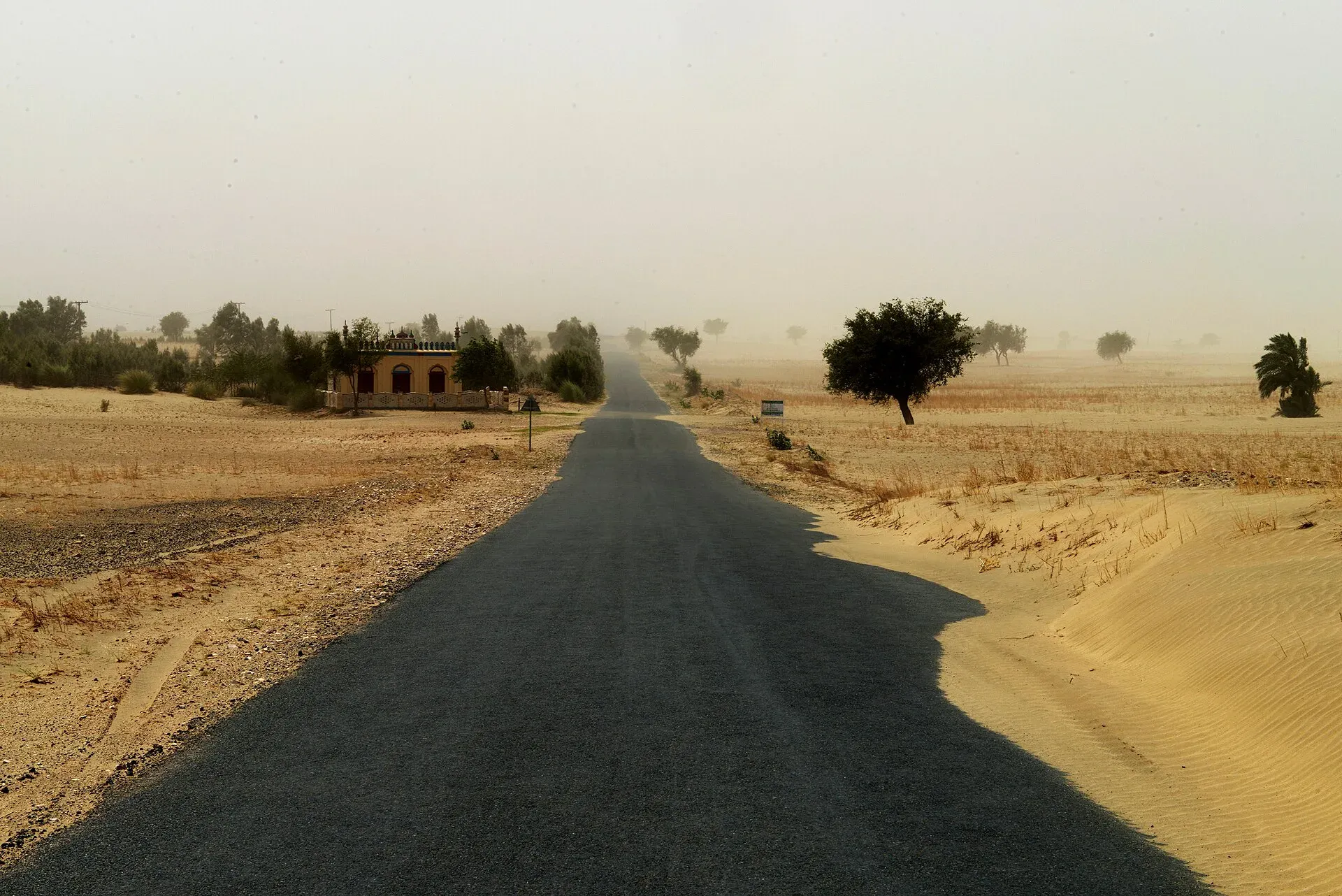
Photo: Vasiq Eqbal, with thanks · CC BY-SA 4.0 · via Wikimedia Commons · temporary stand-in photo

Thal Desert
The Thal is a sandy plain of about 23,000 km2 between the Indus and Jhelum in Punjab, mostly farmed for chickpeas. It hosts the Thal Desert Rally; the 10th edition ran 6 to 9 November 2025.
Overview
The Thal lies in Punjab, bounded by the northern Salt Range foothills and the Indus on the west and the Jhelum and Chenab floodplains to the east. Wikipedia gives it as about 310 km long, up to 119 km wide, and around 23,000 km2. It covers mainly Bhakkar, Layyah, Muzaffargarh and Kot Addu, plus much of Khushab and Mianwali and part of Jhang. The elevation falls from about 200 m in the north to about 120 m in the south. Towns include Mankera, Noorpur Thal, Hayderabad Thal, Dullewala, Piplan and Chowk Azam.
Plan your visit
- Nearest town
- Bhakkar
- Getting there
Main towns are Bhakkar, Layyah, Muzaffargarh, Khushab and Mianwali. More
Best months
Oct – Mar
- Thal Desert
- Related places nearby: Bhakkar, Layyah, Jhang, Mankera Fort, Indus Valley Desert
Landscape and climate
Dunes cover about half to 60% of the desert and can reach about 175 m. Ridges of sand alternate with narrow valleys of flatter, farmable land. The sand is wind-worked sediment brought down by the Indus. Half the region is hyper-arid (under 200 mm of rain a year) and the rest is semi-arid. Mean annual rainfall is 150 to 350 mm, mostly June to August, with dry spells of two to three years between wetter ones. Strong winds blow all year and cause erosion that damages crops.
Summers are typically 32 to 40 C, and hot southerly winds can push temperatures above 45 C. Dust storms are common. Winters range from about 3 to 8 C. Hail in March and April can damage crops and buildings.
Plants, crops and wildlife
Natural vegetation is mostly grasses and sedges used as fodder, with drought-tolerant thorny shrubs. The few native trees include khagal, shareen, acacia, beri (jujube) and karir. Gram (chickpea) is the most successful crop in these conditions, and the Thal produces most of Pakistan's chickpeas. Gram flour is the main cash crop. Wheat and maize are also grown, and the greener fields in winter and early spring contrast with the dunes.
Wikipedia says deer, jackal and other wildlife have fallen sharply since the 1970s. Desert fox, Indian desert cat, chinkara (a gazelle) and Indian hare remain in small numbers. The Thal Game Reserve is estimated to host over 2.5 million birds of 55 species, with numbers peaking around December and January. Migrants include the peregrine falcon, common quail, skylark and rosy starling.
People and livelihoods
Most families farm small plots or keep animals, and live in scattered settlements. Most farmers own less than 5 acres. Livestock (goats, sheep, cattle, buffaloes and camels) is seen as more secure than crops, and camels are used for transport. Tribes named by Wikipedia include the Tiwana, Sial and Mammak. Local crafts use grasses for baskets and thatch, and sheep and camel skins for leather. Health, school and water services are limited in many villages.
Canals and settlement
A canal to irrigate the Thal from the Indus was first proposed in 1873 and raised again several times before the Greater Thal Canal was inaugurated on 16 August 2001. After Partition in 1947 the Thal Development Authority (active 1950 to 1969) settled refugee and migrant families here. It founded over 110 villages and settled over 31,377 families, partly through grants of 15 acres to refugees and migrants who agreed to farm the land.
What to see and do
- Join the Thal Desert Jeep Rally, run by the Tourism Development Corporation of Punjab. The 10th edition ran from 6 to 9 November 2025 in Kot Addu, Layyah and Muzaffargarh (Express Tribune, APP). The route was about 200 km. There is no known announcement for 2026 yet.
- Drive or walk the dunes with a local guide.
- Visit villages near Layyah and Bhakkar.
When to visit
October to March is comfortable. Summers are hot and dusty.
Where to stay and eat
Hotels are in the district towns. In the desert, expect basic meals of roti, lentils and dairy. Camping needs the permission of the landowner.
Good to know
- Ask the district administration or local police about current conditions before you go. For foreign visitors: the UK FCDO (checked 16 November 2026) advises against all but essential travel to Dera Ghazi Khan, which neighbours the south-west. Check the page for your route.
- Keep off cultivated land and respect irrigation channels.
- Entry or event fees will be added soon.
Highlights
- Dunes and farmland between the Indus and Jhelum
- Pakistan's main chickpea (gram) belt
- Thal Desert Jeep Rally in Layyah, Muzaffargarh and Kot Addu
- Villages with livestock and mud houses
- Winter migrant birds
Getting there
Main towns are Bhakkar, Layyah, Muzaffargarh, Khushab and Mianwali. Layyah to Bhakkar is about 77 km and 1.2 hours, Layyah to Kot Addu about 56 km (0.9 hours), Layyah to Muzaffargarh about 111 km (1.8 hours), Bhakkar to Mianwali about 123 km (2.3 hours) and Bhakkar to Khushab about 162 km (3 hours) (OSRM, 17 November 2026, optimistic times); Islamabad to Bhakkar about 392 km and 5.0 hours (OSRM). Buses reach all district towns; local vans and rickshaws cover the rest.
Tips
- Go between October and March.
- Expect sand storms in spring and early summer.
- Use a local driver on dune tracks.
- Ask before entering farmland and fields.
- Carry water; few shops between small towns.
Photos we still need: Thal dunes with chickpea fields (for the 'Landscape and climate' section). Send us yours
Sources and last checked
Last checked Confidence medium5 sources2 still to check
- Last checked
- Method
- Desk research from published sources
- Confidence
- medium
- Checked by
- trek.pk research team
Researched from published sources; not yet checked on the ground by our team. Spot something out of date? Report a mistake.
Sources
- Thal Desert · Wikipedia · checked
- Thal Desert Rally from Nov 6 · The Express Tribune · checked
- Desert Rally 2025 scheduled from Nov 6 to 9 · Associated Press of Pakistan · checked
- OSRM driving route calculation · OpenStreetMap / OSRM project · checked
- Pakistan travel advice (updated 27 Oct 2026) · UK Foreign, Commonwealth & Development Office · checked
Still to be checked on the ground (2)
- Whether a 2026 Thal rally has been scheduled (the TDCP home page lists nothing)
- Wildlife and bird figures rest on single, older sources and are estimates
Nearby and related

Bhakkar
District capital on the edge of the Thal sandy plain, close to the Indus. A farm town with few visitor sights; useful as a stop in the Thal region.

Layyah
District capital in the sandy Thal between the Indus and Chenab, about 143 m above sea level. A quiet Saraiki-speaking market town, with no major sights.

Mianwali
District capital east of the Indus in north-west Punjab. A farm and air-force town with the Chashma and Jinnah barrages nearby.

Muzaffargarh
District capital in south Punjab, between the Chenab and Indus. A farming town of citrus and mango orchards, 37 km from Multan.

Jhang
Old Sial capital on the Chenab, known for the tomb of Heer and Ranjha and the shrine of Sultan Bahu at Garh Maharaja nearby. About 86 km from Faisalabad.

Cholistan Desert
Cholistan is a desert of about 25,800 km2 in Punjab's Bahawalpur Division, with dunes, seasonal ponds called tobas, camel herders and Derawar Fort. Visit October to March.
Mankera Fort
A ruined fort of about fifty acres in the Thal Desert, Bhakkar district. The present fort was begun in 1804 under Nawab Sarbuland Khan Sadozai, on a much older site.
Indus Valley Desert
A desert ecoregion of about 19,500 km2 in north-west Punjab. It overlaps the area known as the Thal and is a habitat description, not a travel destination.