

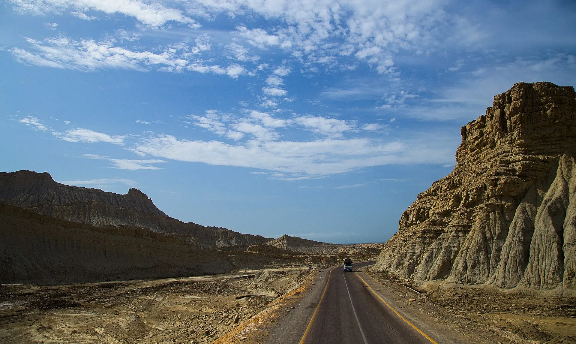
Photo: Furqanlw, with thanks · CC BY-SA 4.0 · via Wikimedia Commons · temporary stand-in photo

N-10 Makran Coastal Highway: Karachi-Gwadar
The N-10 runs 632 km along the Arabian Sea from Karachi to Gwadar past Hingol and Kund Malir. It lies almost wholly in Balochistan, where the UK FCDO advises against all travel, and public transport is barred at night.
Overview
The N-10 is the Makran Coastal Highway, a two-lane National Highway Authority road between Karachi and Gwadar along the Arabian Sea. Wikipedia and Dawn (3 June 2026) give its length as 653 km, and Wikipedia says it was completed in 2003; our own driving measurement from Karachi to Gwadar is 632 km, about 7 hours 25 minutes without stops (OSRM, 16 November 2026). Most of it is empty desert, hill and shoreline, with few villages.
Read this first
Ask the district administration or local police about current conditions before you go. For foreign visitors: the UK FCDO (updated 27 October 2026, checked 16 November 2026) advises against all travel to Balochistan Province. Every kilometre of the N-10 beyond Hub is in Balochistan. Only the first stretch out of Karachi is in Sindh. This page describes the road; it does not recommend the trip.
Route and stops
Distances are from Karachi, measured by OSRM.
- Hub (km 33): the last big town before the coast; fuel and supplies.
- Kund Malir (km 240): a beach at the edge of Hingol National Park.
- Hingol National Park: the road runs through it, past the rock formation known as the Princess of Hope.
- Ormara (km 355): coastal town.
- Pasni (km 513): fishing town; the highway may bypass the centre.
- Gwadar (km 632): port city and the end of the highway.
Road conditions
Dawn (3 June 2026) calls the coastal highway and the M-8 new and smooth, but with few rest stops and poor toilets. A coach crash near Hudd Goth, in the Ormara area, killed nine people on 17 January 2026 (Express Tribune); police blamed overspeeding. The road is paved and has been since the early 2000s, but there is little traffic and long distances between help points. Summer heat on this coast is severe, so the best weather for any trip is the cooler winter months. Sea breezes and sand can drift across the road in places.
Hazards and incidents
- Night travel: Dawn reported on 30 March 2025 that the Gwadar district authorities banned all public transport on the N-10 at night "till further orders". Departures from Karachi or Quetta to Gwadar were limited to 5 am to 10 am, and from Gwadar to 6 am to 1 pm. There is no known notice lifting the order, and Dawn (3 June 2026) says night-time public transport is often banned when violence is feared.
- Security: Dawn's 30 March 2025 report said the restrictions followed attacks on passengers on Balochistan highways. The Gwadar district administration issued a safety alert on 1 March 2026 (Express Tribune).
- Remoteness: a breakdown can mean hours without phone signal or help.
Fuel and services
Fill up at Karachi and Hub. Between Hub and Gwadar, fuel and food are available in small towns and roadside stops, but supply is uneven and we have no verified list. Carry spare fuel, water and food, and a spare tyre. Medical care is limited outside Karachi and Gwadar.
What to see
Kund Malir and Hingol are the main stops.
- Kund Malir: a beach beside Hingol National Park. Wikivoyage says desert safaris are offered here.
- Buzi Pass: about 6 km further on, where the road winds between mountains and the sea.
- Princess of Hope and the Sphinx: rock formations in Hingol seen from the road, about 260 km from Karachi by OSRM.
- Hinglaj Mata: a Hindu temple inside Hingol that draws a spring pilgrimage.
- Ormara: a long beach and a bus-stop town. Dawn (3 June 2026) says buses from Turbat and Gwadar stop there for meals on the way to Karachi.
- Gwadar: the port. Wikivoyage lists West Bay beach and Zalzala Jazeera, an island raised by the 2013 earthquake.
Allow most of a day for Karachi to Gwadar: Dawn says the journey takes about eight hours. See the pages on Hingol National Park, Kund Malir, Princess of Hope and the Sphinx, and Gwadar for more.
Safety by section
- Karachi city and the Sindh side: For foreign visitors: the UK FCDO page we checked lists no warning for Karachi itself.
- Hub to Gwadar (Balochistan): FCDO advises against all travel. Night travel by public transport is banned, so plan to arrive well before dark and check with the Balochistan government and local police first.
Highlights
- Along the Arabian Sea for 632 km
- Hingol National Park and the Princess of Hope
- Kund Malir beach
- Ends at Gwadar port
Stops
- HubLast big town before the coast; fuel and supplies
- Kund MalirBeach at the edge of Hingol National Park
- Princess of HopeRock formation in Hingol National Park (OSRM estimate)
- OrmaraCoastal town
- PasniFishing town; the highway may bypass the centre
- GwadarPort city and end of the highway
km: distance from the start along the route.
Numbers follow the stops in order. The map shows the stops, not the road itself.
Where to stay, eat and fuel up
Places to stay
- Avari Towers KarachiCall Avari Towers KarachiMap of Avari Towers Karachi in Google Maps
- Mövenpick KarachiCall Mövenpick KarachiMap of Mövenpick Karachi in Google Maps
- Ramada Plaza by Wyndham Karachi Airport HotelCall Ramada Plaza by Wyndham Karachi Airport HotelMap of Ramada Plaza by Wyndham Karachi Airport Hotel in Google Maps
- Beach Luxury HotelMap of Beach Luxury Hotel in Google Maps
- Karachi Marriott HotelCall Karachi Marriott HotelMap of Karachi Marriott Hotel in Google Maps
- Ramada by Wyndham Karachi CreekCall Ramada by Wyndham Karachi CreekMap of Ramada by Wyndham Karachi Creek in Google Maps
Places to eat
- Port Grand - KarachiCall Port Grand - KarachiMap of Port Grand - Karachi in Google Maps
- Kolachi RestaurantCall Kolachi RestaurantMap of Kolachi Restaurant in Google Maps
- Bar BQ Tonight CliftonCall Bar BQ Tonight CliftonMap of Bar BQ Tonight Clifton in Google Maps
- Kaybees MACHSCall Kaybees MACHSMap of Kaybees MACHS in Google Maps
- Karachi Hassan Zai Koyla KarahiCall Karachi Hassan Zai Koyla KarahiMap of Karachi Hassan Zai Koyla Karahi in Google Maps
- Gul Plaza Shopping CentreMap of Gul Plaza Shopping Centre in Google Maps
Essential services fuel stations, mechanics, banks, pharmacies and hospitals and clinics
Fuel
- PSO Petrol Pump (Stadium Service Station)Call PSO Petrol Pump (Stadium Service Station)Map of PSO Petrol Pump (Stadium Service Station) in Google Maps
- ShellCall ShellMap of Shell in Google Maps
- KHAZAN ASSOCIATES PARCO Petrol PumpCall KHAZAN ASSOCIATES PARCO Petrol PumpMap of KHAZAN ASSOCIATES PARCO Petrol Pump in Google Maps
- PSO Petrol PumpMap of PSO Petrol Pump in Google Maps
- PSO Petrol PumpCall PSO Petrol PumpMap of PSO Petrol Pump in Google Maps
- Attock Petrol Pump (Classic filling Station)Map of Attock Petrol Pump (Classic filling Station) in Google Maps
Mechanics and tyre shops
- Suzuki Naseer AutosCall Suzuki Naseer AutosMap of Suzuki Naseer Autos in Google Maps
- Ghazi Autos Karachi Hybrid & EFI Mechanics | Auto Electrician Services | Scanning & Diagnostic Workshop / GarageCall Ghazi Autos Karachi Hybrid & EFI Mechanics | Auto Electrician Services | Scanning & Diagnostic Workshop / GarageMap of Ghazi Autos Karachi Hybrid & EFI Mechanics | Auto Electrician Services | Scanning & Diagnostic Workshop / Garage in Google Maps
- Toyota Highway MotorsCall Toyota Highway MotorsMap of Toyota Highway Motors in Google Maps
- Bashir Autos Car ACCall Bashir Autos Car ACMap of Bashir Autos Car AC in Google Maps
Banks and money exchange
- State Bank of PakistanCall State Bank of PakistanMap of State Bank of Pakistan in Google Maps
Pharmacies
- Al Jadeed Super MarketCall Al Jadeed Super MarketMap of Al Jadeed Super Market in Google Maps
- Imtiaz Supermarket - Awami Markaz - KHICall Imtiaz Supermarket - Awami Markaz - KHIMap of Imtiaz Supermarket - Awami Markaz - KHI in Google Maps
- Hydri Super MarketCall Hydri Super MarketMap of Hydri Super Market in Google Maps
- Imtiaz Supermarket - Clifton - KHICall Imtiaz Supermarket - Clifton - KHIMap of Imtiaz Supermarket - Clifton - KHI in Google Maps
- SPAR SharfabadCall SPAR SharfabadMap of SPAR Sharfabad in Google Maps
- Springs StoreCall Springs StoreMap of Springs Store in Google Maps
Hospitals and clinics
- Hashmanis Hospital NumaishCall Hashmanis Hospital NumaishMap of Hashmanis Hospital Numaish in Google Maps
- A.O. HOSPITALCall A.O. HOSPITALMap of A.O. HOSPITAL in Google Maps
- Liaquat National Hospital - Institute for Undergraduate and Postgraduate Medical Studies and Health SciencesCall Liaquat National Hospital - Institute for Undergraduate and Postgraduate Medical Studies and Health SciencesMap of Liaquat National Hospital - Institute for Undergraduate and Postgraduate Medical Studies and Health Sciences in Google Maps
- Indus Hospital & Health NetworkCall Indus Hospital & Health NetworkMap of Indus Hospital & Health Network in Google Maps
- National Medical Centre (NMC)Call National Medical Centre (NMC)Map of National Medical Centre (NMC) in Google Maps
- Patel HospitalCall Patel HospitalMap of Patel Hospital in Google Maps
Listings come from Google Maps data and are unverified: phone numbers, opening months and prices may have changed. Report a problem · Own one of these? Claim it
More safety notes
- FCDO (updated 27 October 2026, checked 16 November 2026): advises against all travel to Balochistan Province, which covers the N-10 beyond Hub.
- Night travel: all public transport banned at night on the N-10 "till further orders" (Dawn, 30 March 2025); Gwadar departures limited to set morning hours. No notice lifting it was found.
- Gwadar: district safety alert, 1 March 2026 (Express Tribune).
- Do not travel without current local advice.
Tips
- Read the current FCDO and Balochistan government advice before planning.
- Plan to be off the road well before dark; night public transport is banned.
- Carry fuel, water, food and a spare tyre.
- Let someone know your route and expected arrival.
Sources and last checked
Last checked Confidence medium10 sources5 still to check
- Last checked
- Method
- Desk research from published sources
- Confidence
- medium
- Checked by
- trek.pk research team
Researched from published sources; not yet checked on the ground by our team. Spot something out of date? Report a mistake.
Sources
- OSRM driving route service: distances and times measured 16 November 2026 (drive times are without stops) · OSRM / OpenStreetMap contributors · checked
- Pakistan travel advice: warnings and insurance (updated 27 October 2026) · UK Foreign, Commonwealth and Development Office · checked
- National highways of Pakistan · Wikipedia · checked
- Night travel banned on key highways in Balochistan (30 March 2025) · Dawn · checked
- Makran Coastal Highway · Wikipedia · checked
- Safety alert issued in Gwadar (1 March 2026) · The Express Tribune · checked
- Hingol National Park · Wikipedia · checked
- If you need to use the loo on the way to Turbat (3 Jun 2026) · Dawn · checked
- Nine killed, 36 injured as passenger coach overturns on Makran Coastal Highway (17 Jan 2026) · The Express Tribune · checked
- Gwadar (Wikivoyage) · Wikivoyage · checked
Still to be checked on the ground (5)
- Whether the March 2025 night-travel ban on the N-10 is still in force (no notice lifting it found; Dawn June 2026 says bans are common)
- Fuel availability between Hub and Gwadar (only undated forum reports: little or no Pakistani fuel between Windar and Ormara; not used)
- Pasni: whether the highway bypasses the town (our routing point lies 23 m from a road, but no source mentions a bypass; the Gwadar to Pasni section is given as 132 km by a contractor page, against 119 km on our figures)
- Any permission or escort rule for travellers (none found; coast guard check posts reported by forum users)
- Hingol National Park area: Wikipedia gives about 6,100 sq km, Wikivoyage 1,650 sq km
Nearby and related

Hub
Industrial town and headquarters of Hub District, just over the Sindh border from Karachi, on the Karachi–Quetta and coastal roads.

Kund Malir
Remote Arabian Sea beach at the edge of Hingol National Park, about 236 km west of Karachi on the Makran Coastal Highway. Fuel and food are scarce. Balochistan is under UK FCDO 'all travel' advice.

Hingol National Park
Pakistan's largest national park, about 6,100 square kilometres along the Makran Coastal Highway: desert canyons, mud volcanoes, the Hingol River, the Princess of Hope rock and the Hinglaj Mata temple.

Princess of Hope and the Sphinx (Hingol)
Two wind-carved rock formations inside Hingol National Park, seen from the Makran Coastal Highway near Buzi Pass. Balochistan travel is advised against by the UK FCDO.

Ormara
Small port town on the Makran Coastal Highway, about 351 km west of Karachi, with a curved double-bay beach and a naval base. Services are limited. Balochistan is under UK FCDO 'all travel' advice.

Pasni
Fishing town on the Makran coast, about 508 km from Karachi, with open beaches and the boat crossing point for Astola Island. Services are limited. Balochistan is under UK FCDO 'all travel' advice.

Gwadar
Arabian Sea port town and Gwadar District headquarters, a fishing settlement that Pakistan bought from Oman in 1958 and now a CPEC port.
Buzi Pass
A section of the Makran Coastal Highway (N-10) in Hingol National Park, Balochistan, known for roadside rock formations. The UK advises against all travel to Balochistan.

Karachi, Makran Coastal Highway and Gwadar
A reference page for the 632 km Makran Coastal Highway (N-10) from Karachi to Gwadar. For foreign visitors: the UK FCDO advises against all travel to Balochistan, and night travel is restricted on the road. Not recommended without current local advice.