

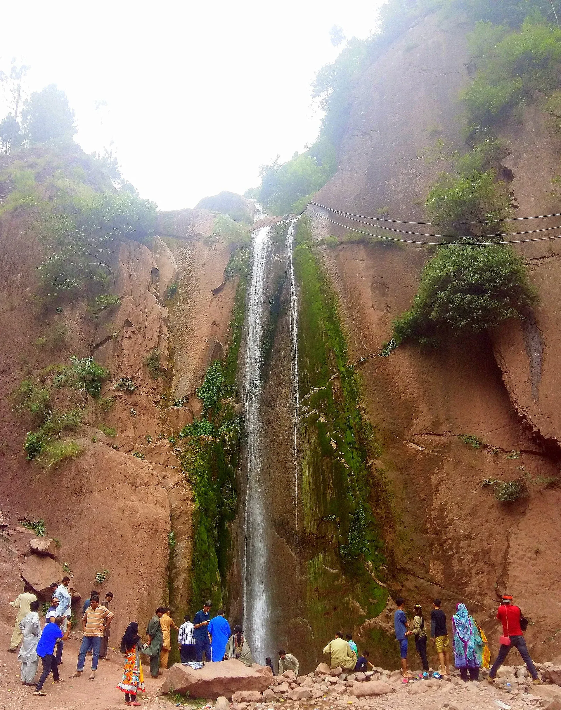
Photo: Ajwad666, with thanks · CC BY-SA 4.0 · via Wikimedia Commons · temporary stand-in photo

Dhani Waterfall
A 15 m roadside waterfall on the Neelum Valley road in Nasirabad tehsil, Azad Kashmir, about 30 to 38 km from Muzaffarabad. A vehicle accident near it in July 2024 killed two people.
Overview
Dhani Waterfall (also Dhani Noseri) is on the main road into the Neelum Valley in Nasirabad tehsil, Azad Kashmir. The Friday Times (21 August 2020) and Wikipedia both give a height of 15 m, and Wikipedia places it at about 1,092 m above sea level. The fall is beside the road, so travellers heading up the valley often stop here. Claims that it is the highest in the valley are not confirmed.
Plan your visit
- Nearest town
- Muzaffarabad
- Getting there
From Muzaffarabad, drive up the Neelum Valley road. The fall is on the main road in Nasirabad tehsil. The Friday Times gives 30 km (40 minutes); OSRM gives about 36 km and 41 minutes (checked 16 November 2026). More
Best months
Apr – Jun, Sep – Oct
- Dhani Waterfall
- Related places nearby: Neelum Valley, Muzaffarabad, Athmuqam, Sharda, Kel Camping (Neelum)
Up the Neelum road
The Neelum River flows down to Muzaffarabad, where it joins the Jhelum. The valley is thickly wooded, with elevations of about 1,200 to 2,300 m and peaks to about 5,200 m, and the Line of Control runs through it. In order from Muzaffarabad, Dhani is the first stop, followed by Kutton Waterfall (about 73 km from Muzaffarabad and about 2.5 hours by car, per the Friday Times), Athmuqam, the district headquarters, then Keran, Sharda and Kel. The Neelum Valley page and the Neelum Valley road trip cover the whole route.
What to see and do
- Roadside viewing. It is an easy first stop on the way up the valley.
- Photography. Mist and greenery make a good setting on clear days.
- Other falls on the route. The Friday Times also names Kutton, Jamgar, Kel Seri, Machal near Halmat, and Kishan Ganga near Kail.
When to visit
No official season is published. The fall is fed by rain and snowmelt, so water is likely to be strongest in spring and summer. Landslides can close the Neelum road during the monsoon (July and August), so check conditions before you set out.
Where to stay and eat
Muzaffarabad has the nearest range of hotels. Further up the valley, guesthouses operate at Athmuqam, Sharda and Kel. No official facilities at the fall are known.
Good to know
- Distance. The Friday Times says 30 km (a 40-minute drive) from Muzaffarabad; Wikipedia says about 38 km. The OSRM routing service gives about 36 km and 41 minutes (an estimate, checked 16 November 2026).
- Safety. In July 2024 a tourist vehicle went into a ravine near the waterfall, killing two people and injuring four. Sources differ on whether it was a van or a jeep. Mountain roads here are narrow and edged with drops, so drive in daylight and pull over only at safe spots.
- Fees. No official fee information found; current fees will be added soon.
- Etiquette. Stop only where the road is wide, and take litter away.
- Ask the district administration or local police about current conditions before you go. Travel advice. For foreign visitors: the UK FCDO page (updated 27 October 2026, checked 16 November 2026) advises against all but essential travel to Azad Jammu and Kashmir, and against all travel within 10 miles of the Line of Control. It does not name individual valley sites, so check the current page and your route before you go.
Highlights
- 15 m fall beside the Neelum Valley road
- About 30 to 38 km from Muzaffarabad
- Easy first stop on the valley route
- Elevation about 1,092 m
Getting there
From Muzaffarabad, drive up the Neelum Valley road. The fall is on the main road in Nasirabad tehsil. The Friday Times gives 30 km (40 minutes); OSRM gives about 36 km and 41 minutes (checked 16 November 2026). Local buses and shared vehicles use the valley road.
Tips
- Park only on wide, safe stretches of road
- Check road and landslide news before driving up the valley
- Do not climb on wet rocks for photos
- Check FCDO advice and the Line of Control rule before travelling
Photos we still need: the Neelum road at Dhani and the surrounding valley. Send us yours
Sources and last checked
Last checked Confidence medium5 sources2 still to check
- Last checked
- Method
- Desk research from published sources
- Confidence
- medium
- Checked by
- trek.pk research team
Researched from published sources; not yet checked on the ground by our team. Spot something out of date? Report a mistake.
Sources
- Dhani Waterfall · Wikipedia · checked
- Azad Kashmir's Majestic Waterfalls · The Friday Times · checked
- OSRM demo routing service (driving routes) · Project OSRM · checked
- Pakistan travel advice: warnings and insurance · UK Foreign, Commonwealth & Development Office · checked
- Neelum Valley · Wikipedia · checked
Still to be checked on the ground (2)
- Current road and landslide status on the Neelum road (changes by the day)
- Best months (no official source; water source suggests spring and summer)
Nearby and related

Neelum Valley
A long, forested river valley in Azad Kashmir running north-east from Muzaffarabad to Sharda, Kel and Arang Kel. It runs close to the Line of Control, so check access before you go.

Muzaffarabad
The capital of Azad Jammu and Kashmir, at 737 m where the Neelum and Jhelum rivers meet. It is the gateway to the Neelum Valley and a rebuilt city after the 2005 earthquake.

Kutton Waterfall
A waterfall in the Neelum Valley, Azad Kashmir, about 73 to 80 km from Muzaffarabad. For foreign visitors: the UK FCDO advises against all but essential travel to AJK and all travel within 10 miles of the Line of Control.
Athmuqam
The headquarters of Neelum District in Azad Kashmir, at about 1,350 m in the Neelum Valley. UK advice is against all but essential travel to AJK.

Sharda
A small town in the upper Neelum Valley of Azad Kashmir at about 1,981 m, known for the ruins of the Sharada Peeth temple site. It is close to the Line of Control, and official travel advice is strict.

Kel Camping (Neelum)
Kel is a village in the upper Neelum Valley and the base for the Arang Kel chairlift and the Shounter Lake trips. Tent camps are common nearby, but the area is close to the Line of Control and UK advice is against travel.
Neelum Valley
A 4-5 day road trip from Islamabad to Muzaffarabad and up the Neelum River by Athmuqam, Keran, Sharda and Kel, about 275 km, with a jeep track beyond Kel. Check current advice: the valley runs close to the Line of Control.