

Photo: Umar Jamshaid, with thanks · CC BY-SA 4.0 · via Wikimedia Commons · temporary stand-in photo

Sharda
A small town in the upper Neelum Valley of Azad Kashmir at about 1,981 m, known for the ruins of the Sharada Peeth temple site. It is close to the Line of Control, and official travel advice is strict.
Overview
Sharda is a tehsil in Neelum District, Azad Jammu and Kashmir, at about 1,981 m on the Neelum river (Wikipedia). It is best known for Sharada Peeth, a ruined temple to the goddess Sharada. The twin peaks Shardi and Nardi overlook the valley. A track along the Surgan stream leads towards the Noori Nar Pass and the Kaghan valley.
Plan your visit
- Getting there
Road: along the Neelum Valley road from Muzaffarabad, about 128 km (OSRM, about 2 hours 25 minutes, optimistic, using approximate town-centre coordinates), so allow most of a day on the real road; More
Best months
May – Oct
- Sharda
- Related places nearby: Neelum Valley, Arang Kel, Saral Lake, Athmuqam
Sharada Peeth
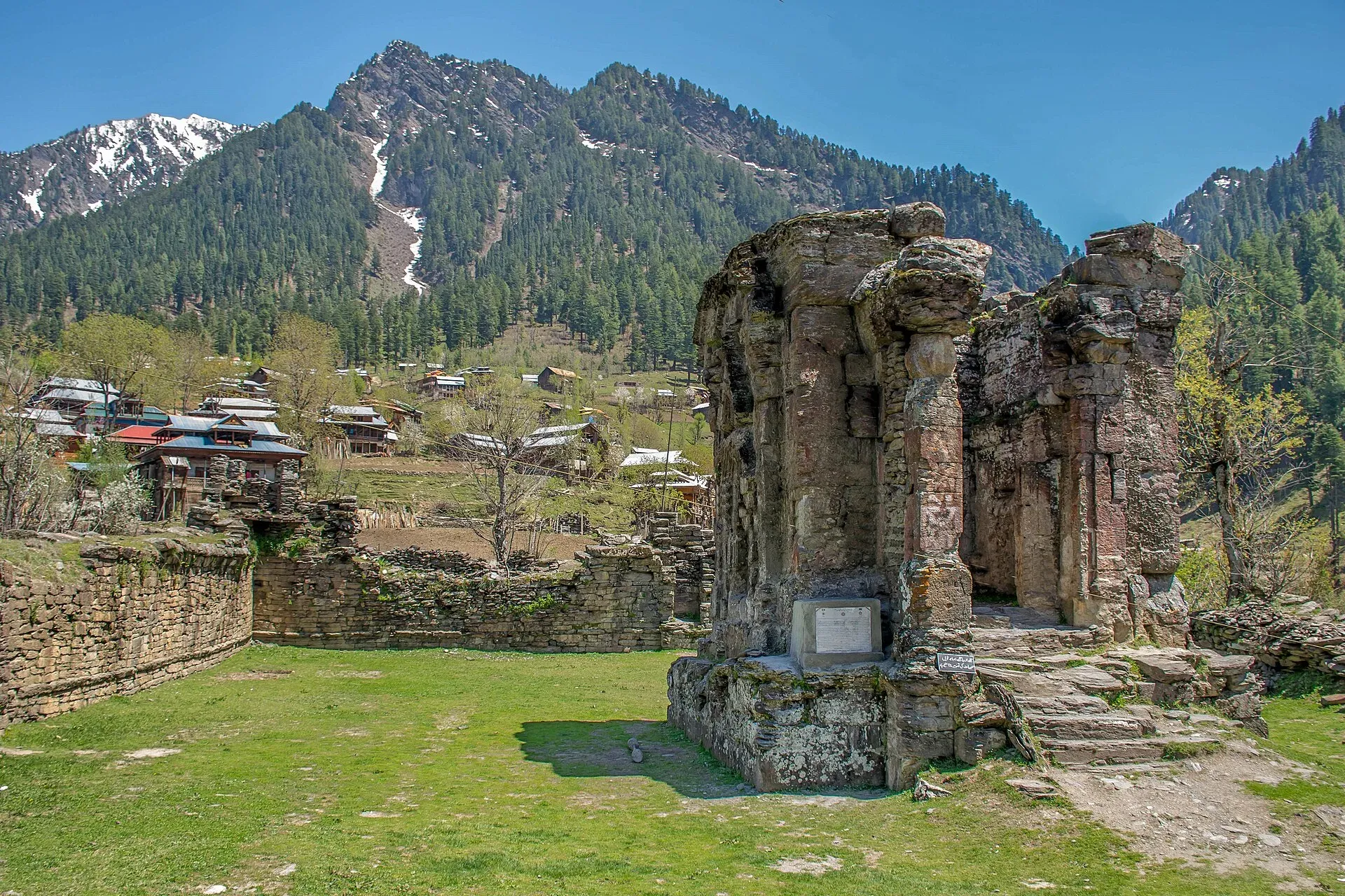
Wikipedia says that between the 6th and 12th centuries CE the site was among the most prominent temple universities in South Asia, with a library, and that the Sharada script is named after it. Kashmir came to be called Sharada Desh, "the country of Sharada". The probable patron was the king Lalitaditya Muktapida (reigned 724 to 760 CE), though there is no firm evidence. Later visitors described the site, from the 11th-century scholar Al-Biruni, who relied on hearsay, to the Sultan of Kashmir Zain-ul-Abidin in 1422. Maharaja Gulab Singh repaired the temple in the Dogra period. After the 1947 to 1948 war the site fell into disuse.
In Hindu tradition it is one of the 18 Maha Shakta pithas, and for Kashmiri Pandits it is one of the three holiest pilgrimage sites. The Madhumati stream, which joins the Neelum here, is a traditional bathing place for pilgrims.
What remains is built of red sandstone in the Kashmiri style. A stone staircase on the west side leads to a raised plinth about 1.6 m high. The temple stands in a walled quadrangle of about 43 m by 29 m. Inside is a small square cella, about 3.7 m across, with a slab that covers a sacred spring. The roof has gone, and the interior is open to the weather. Wikipedia's page is flagged for disputed accuracy, so treat the finer measurements with care.
What to see and do
- Sharada Peeth ruins: the temple, with its raised plinth and stone walls. Ask locally about access, as arrangements can change.
- Neelum river views: the river runs through a steep valley.
- Nearby villages: Wikipedia names Surgan, Maidaan and Kishan Ghatti.
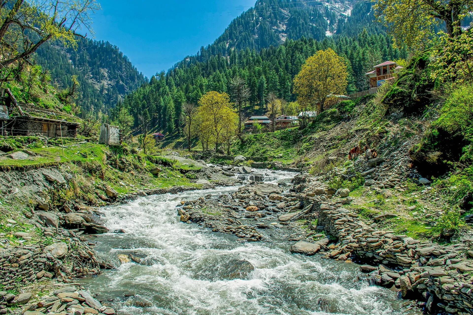
Photo: Umar Jamshaid, with thanks · CC BY-SA 3.0 · via Wikimedia Commons · temporary stand-in photo

When to visit
May to October. Winter snow can block the upper road.
Getting there
The Neelum Valley road runs from Muzaffarabad about 128 km by OSRM, about 2 hours 25 minutes (optimistic), so allow most of a day on the real road. Wikipedia's Sharada Peeth article gives about 150 km from Muzaffarabad. See Neelum Valley and Upper Neelum for the road, and Arang Kel further up the valley.
Where to stay and eat
A few simple hotels and guesthouses serve visitors; AJK Tourism also runs facilities in the valley. Food is simple: rice, daal, meat, bread and tea.
Good to know
- Sharda is a small town, so carry cash and supplies from Muzaffarabad. There is no confirmed fuel, ATM or clinic details.
- Dress modestly and ask before photographing people.
- Visitors must carry ID. Rules for foreign visitors and for adventure activities in Neelum have been reported as needing a No Objection Certificate from the AJK Tourism and Archaeology Department, but there is no known current official notice. Check with that department before you go.
Ask the district administration or local police about current conditions before you go. Travel advice: For foreign visitors: the UK FCDO advises against all but essential travel to Azad Jammu and Kashmir, and against all travel within 10 miles of the Line of Control (advice updated 27 October 2026, checked 16 November 2026). Wikipedia puts Sharada Peeth about 10 km from the Line of Control, so Sharda is very likely to fall inside the 10-mile area. Read the live advice and plan accordingly.
Highlights
- Sharada Peeth temple ruins
- Upper Neelum Valley
- Shardi and Nardi peaks
- Close to the Line of Control
Hotels, food, fuel and services in Sharda
Places to stay
- Sharda Highland HotelCall Sharda Highland HotelMap of Sharda Highland Hotel in Google Maps
- Kashmir Sharda View Guest HouseCall Kashmir Sharda View Guest HouseMap of Kashmir Sharda View Guest House in Google Maps
- Neelum Star River Guest HouseCall Neelum Star River Guest HouseMap of Neelum Star River Guest House in Google Maps
- Sharda ResidencyCall Sharda ResidencyMap of Sharda Residency in Google Maps
- Wadi Resort Sharda Valley, AJKCall Wadi Resort Sharda Valley, AJKMap of Wadi Resort Sharda Valley, AJK in Google Maps
- AJK Tourism Rest HouseMap of AJK Tourism Rest House in Google Maps
Listings come from Google Maps data and are unverified: phone numbers, opening months and prices may have changed. Report a problem · Own one of these? Claim it
Tips
- Read the live UK FCDO advice first.
- Check access rules with AJK Tourism and Archaeology before you travel.
- Carry ID and cash.
- Dress modestly.
Photos we still need: the Neelum river at Sharda and the Surgan stream track. Send us yours
Sources and last checked
Last checked Confidence low5 sources5 still to check
- Last checked
- Method
- Desk research from published sources
- Confidence
- low
- Checked by
- trek.pk research team
Researched from published sources; not yet checked on the ground by our team. Spot something out of date? Report a mistake.
Sources
- Sharda, Azad Kashmir · Wikipedia · checked
- Neelum Valley · Wikipedia · checked
- Pakistan travel advice · UK FCDO (GOV.UK) · checked
- OSRM driving route service: Muzaffarabad to Sharda, measured 17 November 2026 (optimistic, without stops) · OpenStreetMap / OSRM · checked
- Sharada Peeth · Wikipedia (page carries an accuracy-dispute tag) · checked
Still to be checked on the ground (5)
- Exact distance from the Line of Control (not in Wikipedia; FCDO gives only the 10-mile zone)
- Entry rules for foreigners and adventure activities (no official notice found)
- Fuel, ATM and clinic availability
- Access to the Sharada Peeth site
- Wikipedia gives about 150 km from Muzaffarabad to Sharda, OSRM 128 km; confirm the real road distance and time
Nearby and related

Neelum Valley
A long, forested river valley in Azad Kashmir running north-east from Muzaffarabad to Sharda, Kel and Arang Kel. It runs close to the Line of Control, so check access before you go.

Neelum River
A 245 km river called the Kishanganga in India. About 195 km flows through Azad Kashmir's Neelum Valley before it joins the Jhelum at Muzaffarabad. Border-zone travel advice applies.

Muzaffarabad
The capital of Azad Jammu and Kashmir, at 737 m where the Neelum and Jhelum rivers meet. It is the gateway to the Neelum Valley and a rebuilt city after the 2005 earthquake.

Arang Kel
A hilltop village and meadow at about 2,554 m above Kel in the Neelum Valley, reached by a chairlift across the river and a steep walk.
Saral Lake
A glacial lake at about 4,100 m on the Neelum and Kaghan side of Azad Kashmir, reached by a track from Sharda through Gumot National Park. A remote, high-altitude trip.
Athmuqam
The headquarters of Neelum District in Azad Kashmir, at about 1,350 m in the Neelum Valley. UK advice is against all but essential travel to AJK.