

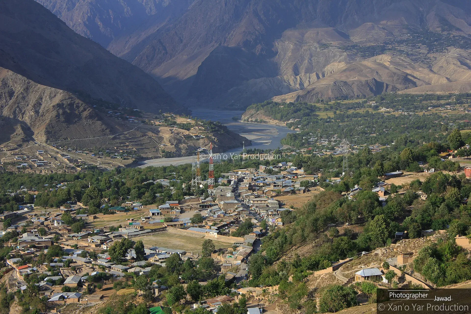
Photo: Jawad Ullah, with thanks · CC BY-SA 4.0 · via Wikimedia Commons · temporary stand-in photo

Drosh
A river town at about 1,359 m in Lower Chitral, on the N-45 road south of Chitral city. It is the largest town in Lower Chitral after Chitral itself and a common stop on the way to the Kalash valleys.
Overview
Drosh is a town in Lower Chitral District, Khyber Pakhtunkhwa, at about 1,359 m (Wikipedia). It stands on river benches above farmland near where the Bashgal (Landai Sin) river meets the Kunar (Chitral) river. Wikipedia gives about 20,000 people at the 2017 census. It lies on the Drosh to Jalalabad road, once part of a major trade route from India to Kabul, so the Afghan border country is not far away.
Drosh was a property of the Mehtar of Chitral, who appointed princes as governors. It became a tehsil, and a municipal office was set up in 2017.
Plan your visit
- Nearest town
- Chitral
- Getting there
Road: about 42 to 46 km south of Chitral city. OSRM gives roughly 35 to 40 minutes depending on the start point (checked 17 November 2026); allow longer for the road and checkpoints, on the N-45. More
Best months
Apr – Jun, Sep – Oct
- Drosh
- Related places nearby: Chitral, Kalash Valleys (Bumburet, Rumbur, Birir), Chitral Valley, Lowari Tunnel, Dir, Biori Valley
People and setting
Drosh is the main town of Drosh tehsil in Lower Chitral District, which was created in 2018. The tehsil covers 331 sq km and had 109,033 people at the 2023 census, a far denser population than Chitral tehsil (Wikipedia). Across Lower Chitral about 88 per cent of people speak Khowar, the language of the Kho people. Pashto is spoken by about 9 per cent, mainly in the south-east of the district, and Kalasha by about 1.6 per cent. Gujjar families, historically herders, have settled in the southern valleys.
What to see and do
- River and farm views: walks along the benches above the river and through fields.
- Local bazaar: everyday shops and food stalls.
- Base for Chitral valley: Chitral city and its fort and museum are about 42 to 46 km north by road.
- Kalash valleys: the roads to Bumburet, Rumbur and Birir leave the main road in this stretch. See the Kalash valleys page.
The river and the farmland
The Chitral river, which becomes the Kunar river as it flows south into Afghanistan, runs beside the town. The town stands on river benches above farmland (Wikipedia). Walks here are simple strolls on village paths. Ask locally where you can go, since the area is security-sensitive.
When to visit
April to June and September to October are the most comfortable. Summers are hot in the lower valley, and winter nights are cold.
Where to stay and eat
Accommodation is limited, with a few guesthouses and small hotels near the main road. Most visitors stay in Chitral city instead. Food is simple: rice, meat, bread and tea.
Good to know
- There is no known source confirming fuel, ATM or hospital details for Drosh. Plan from Chitral.
- Dress modestly and ask before photographing people.
- This area lies in a security-sensitive part of KP, so ask locally. For foreign visitors: the UK FCDO advises against all travel on the N-45 highway from north of the Mardan ring road to the edge of Chitral city, including the Kalash valleys (advice updated 27 October 2026, checked 17 November 2026), and notes KP emergency measures and Governor's Rule since 11 October 2026. Read the live advice before you plan. Drosh is on that road, so the advice applies to it.
Highlights
- Largest town in Lower Chitral after Chitral city
- Old trade route to Jalalabad
- River and farmland setting
- Near the Kalash valley turnings
Getting there
Road: about 42 to 46 km south of Chitral city. OSRM gives roughly 35 to 40 minutes depending on the start point (checked 17 November 2026); allow longer for the road and checkpoints, on the N-45. From the south the N-45 comes via Dir and the Lowari Tunnel.
Hotels, food, fuel and services in Drosh
Places to eat
Essential services fuel stations, ATMs and hospitals and clinics
Fuel
- PSO ICC-II FILLING STATION-Drosh ChitralCall PSO ICC-II FILLING STATION-Drosh ChitralMap of PSO ICC-II FILLING STATION-Drosh Chitral in Google Maps
- Gul Filling StationCall Gul Filling StationMap of Gul Filling Station in Google Maps
- Rakaposhi filling stationCall Rakaposhi filling stationMap of Rakaposhi filling station in Google Maps
ATMs
- HBL DroshMap of HBL Drosh in Google Maps
- NBP Drosh BranchMap of NBP Drosh Branch in Google Maps
- HBL ATMMap of HBL ATM in Google Maps
Hospitals and clinics
- Tehsil Headquarter Hospital Drosh.Map of Tehsil Headquarter Hospital Drosh. in Google Maps
- Al Muhsin Medical StoreCall Al Muhsin Medical StoreMap of Al Muhsin Medical Store in Google Maps
Listings come from Google Maps data and are unverified: phone numbers, opening months and prices may have changed. Report a problem · Own one of these? Claim it
Tips
- Read the live FCDO advice before any plan that uses the N-45.
- Stay in Chitral city for the best choice of rooms.
- Check road conditions and security locally.
- Dress modestly.
Photos we still need: the Chitral or Kunar river at Drosh in a high-resolution open-licence image. Send us yours
Sources and last checked
Last checked Confidence medium4 sources3 still to check
- Last checked
- Method
- Desk research from published sources
- Confidence
- medium
- Checked by
- trek.pk research team
Researched from published sources; not yet checked on the ground by our team. Spot something out of date? Report a mistake.
Sources
- Drosh · Wikipedia · checked
- OSRM driving routes (road distances and times) · Project OSRM / OpenStreetMap · checked
- Pakistan travel advice · UK FCDO (GOV.UK) · checked
- Lower Chitral District (Wikipedia) · Wikipedia · checked
Still to be checked on the ground (3)
- Whether any foreign visitor access to Drosh and the Kalash valleys is possible in practice (FCDO advises against all travel on this stretch of the N-45; local rules not found)
- Fuel, ATM and hospital availability (no source found; Wikipedia silent)
- Exact junction details for the Kalash valley roads
Nearby and related

Chitral
The main town of Lower Chitral District, at about 1,500 m on the Chitral River, with a historic fort, a royal mosque and views of Tirich Mir. The base for the Kalash valleys.

Kalash Valleys (Bumburet, Rumbur, Birir)
Three side valleys of the Chitral River, home to the Kalasha people, who keep their own religion, language and festivals. Visit with respect and check security advice first.

Chitral Valley
The long Chitral River valley at the foot of the Hindu Kush, with Chitral town's fort and Shahi Mosque, the Lowari Tunnel route, Tirich Mir views and side valleys leading to Kalash and Shandur.

Lowari Tunnel
A road tunnel of about 10 km under the Lowari Pass, linking Dir with Chitral on the N-45. Opened in 2017, it gives all-year access, but current UK advice is against all travel on this road.

Dir
The old capital of the princely state of Dir, on the Dir River at the foot of the Lowari Pass, with a palace on the hill above. A stop on the road between Peshawar and Chitral.
Biori Valley
A small valley in Upper Chitral where the Palula language is spoken, near Drosh. A cultural and language interest more than a tourist stop.