

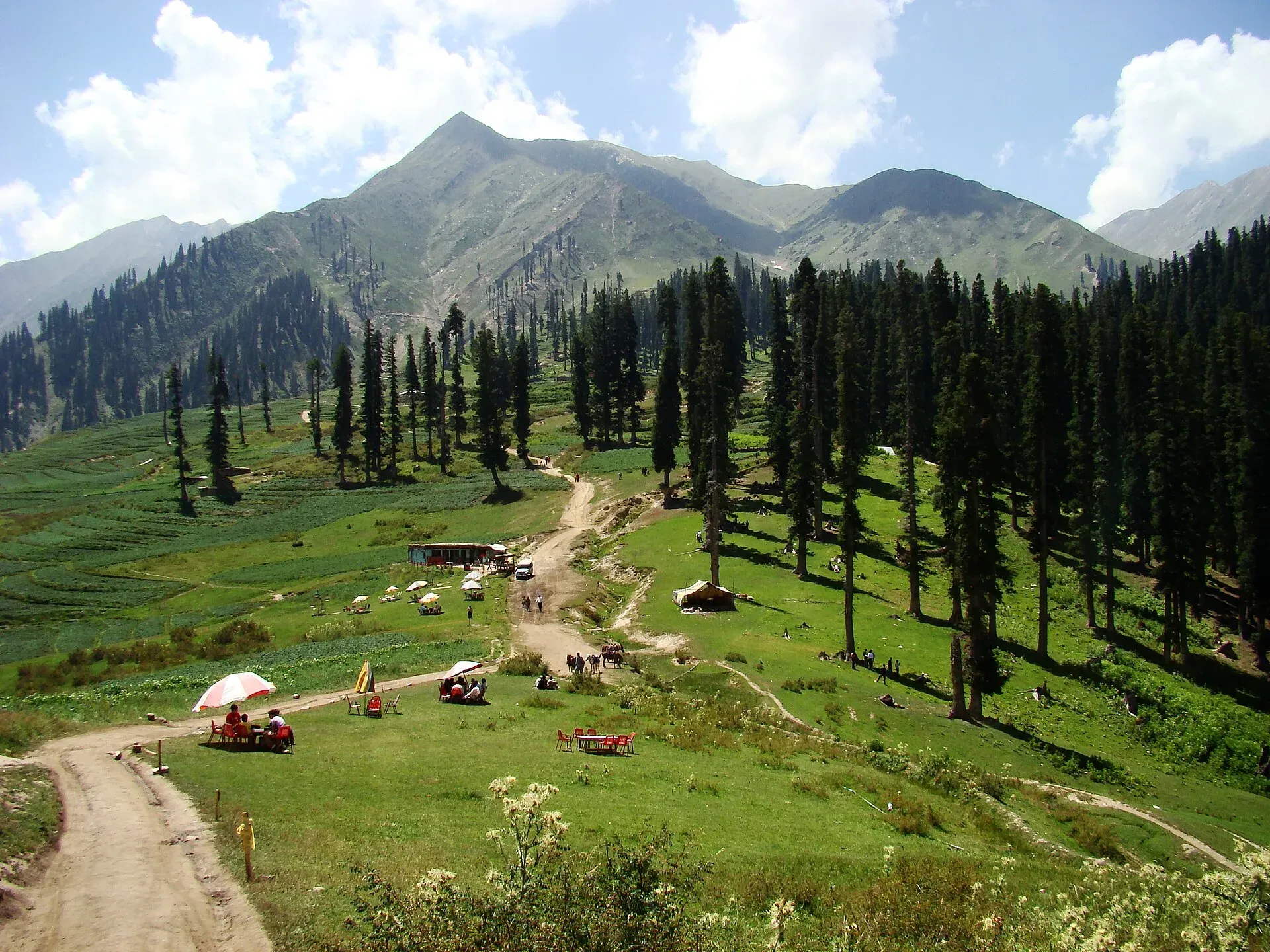
Photo: Faisal Rafiq, with thanks · CC BY-SA 4.0 · via Wikimedia Commons · temporary stand-in photo

Lalazar Meadows
A high pine-edged meadow plateau at about 3,123 m above Batakundi in the Kaghan Valley, reached by a steep jeep road from the valley road.
Overview
Lalazar is a meadow plateau in the upper Kaghan Valley, Mansehra District. Wikipedia's Kaghan Valley article lists it at 3,123 m; a travel guide gives about 3,200 m and puts it about 21 km from Naran. Pine forest surrounds the grass, and the Lalazar road branches off near Batakundi. There are no sourced coordinates, so none are given.
Plan your visit
- Nearest town
- Naran
- Getting there
From Naran drive 16 km to Batakundi (OSRM 16.0 km, 11 minutes, optimistic), then take the steep Lalazar road by 4x4 (about 21 km from Naran in total, per a travel guide). More
Best months
Jun – Sep
What to see and do
- The plateau. Open grass with pines and, in summer, grazing animals, tents and picnickers.
- Views. Ridges of the upper Kaghan Valley.
- Camping. Summer tent camping is the usual way to stay on the meadow; ask locally about any huts.
- Walks. Gentle walks over the plateau and along the stream. Further up the valley road lie Saiful Muluk below, and the Lulusar and Dudipatsar lakes beyond Besal, which have their own pages.
- Nearby. Batakundi is the nearest village with hotels and shops; its page covers the lower valley.
The road from Batakundi
A travel guide gives the access road as 4.2 km long, with a climb of about 431 m. It is a narrow, unpaved jeep track with many hairpin bends, a drop on one side and the Kunhar River far below. Coming from Naran, the turn is on the right before Batakundi village. The guide says the jeep ride takes about half a day with stops, and that the road suits only experienced drivers. It also mentions a five-hour hike over a pass from Saiful Muluk and advises a guide for it. See Batakundi for the village.
The valley around it
The Kaghan Valley runs 155 km from about 650 m up to Babusar Pass at roughly 4,170 m, and its highest peak, Malika Parbat, is about 5,290 m, according to Wikipedia. The Kunhar River starts at Lulusar Lake and flows the length of the valley. Wikipedia lists deodar, blue pine, silver fir, yew and spruce in the coniferous forest. Hindko is the main language and Gujars are a major community. The travel guide says the name Lalazar is Persian, roughly meaning place of tulips, and that alpine flowers bloom in spring and summer.
When to visit
June to September. The road beyond Naran is generally open in summer; snow closes it for much of the year. Check the Babusar road and the Lalazar track with locals before setting out, because weather and landslides change conditions quickly.
Where to stay and eat
Most people stay in Naran or Batakundi, which have hotels, guesthouses and restaurants, and visit Lalazar by jeep for the day or an overnight camp. Meals on the meadow are simple. Camping, jeep and hut charges are not confirmed by an official source; current fees will be added soon.
Good to know
- Road. The Lalazar road is steep and rough and needs a 4x4 with a local driver. Do not take it in rain.
- Altitude. Above 3,000 m, go slowly if you come up from Naran (about 2,400 m).
- Crowds. Eid and peak summer weeks are very busy; the Kaghan Development Authority, set up in 2020, manages the valley.
- Ask the district administration or local police about current conditions before you go. Advice. For foreign visitors: the UK FCDO (updated 27 October 2026, checked 16 November 2026) advises against all travel on the Karakoram Highway between Mansehra and Chilas. It does not list the Kaghan Valley road, but check the page.
- Mobile signal is patchy.
Highlights
- About 3,123 m above Batakundi
- Pine-ringed meadow plateau
- Summer tent camping
- 4x4 road from the valley
Getting there
From Naran drive 16 km to Batakundi (OSRM 16.0 km, 11 minutes, optimistic), then take the steep Lalazar road by 4x4 (about 21 km from Naran in total, per a travel guide). Islamabad to Naran is about 252 km (OSRM 3.1 hours, optimistic; allow 6 to 8 hours in summer).
Tips
- Hire a jeep and driver in Naran or Batakundi.
- Bring warm layers and rain gear.
- Check road conditions before driving up.
Photos we still need: the Lalazar jeep track with the Kunhar valley below; tents on the Lalazar meadow. Send us yours
Sources and last checked
Last checked Confidence low4 sources4 still to check
- Last checked
- Method
- Desk research from published sources
- Confidence
- low
- Checked by
- trek.pk research team
Researched from published sources; not yet checked on the ground by our team. Spot something out of date? Report a mistake.
Sources
- Kaghan Valley · Wikipedia · checked
- Lalazar Valley, Naran, Kaghan · Pakistan Traveler · checked
- Pakistan travel advice (warnings and insurance; updated 27 October 2026) · UK Foreign, Commonwealth & Development Office · checked
- OSRM driving route service (distances and times, measured 16 November 2026; times are optimistic) · OSRM · checked
Still to be checked on the ground (4)
- Altitude (Wikipedia: 3,123 m; a travel guide says about 3,200 m)
- Coordinates (none found for the meadow itself)
- Road and camping rules and fees
- Jeep fares and whether huts operate on the meadow
Nearby and related

Kaghan Valley (with Naran)
A 155 km Himalayan valley above Balakot along the Kunhar River, with Shogran, Naran, Saiful Muluk and Lulusar lakes, and the road to Babusar Pass. Open mainly from May to October.

Batakundi
A meadow village on the Kunhar River about 15 to 16 km above Naran at roughly 2,624 m, the base for the Lalazar road and a stop on the way to Babusar.

Naran
The main base of the Kaghan Valley, at 2,409 m beside the Kunhar River. Naran is the starting point for Saiful Muluk, Lulusar and the road to Babusar Top.

Saiful Muluk
The best-known lake of the Kaghan Valley, at 3,224 m above Naran, with Malika Parbat behind it. It is about 9 km from Naran, reached by jeep, and is snowbound and frozen in winter.

Babusar Pass
A 4,173 m summer road pass on the N-15 linking the Kaghan valley with Chilas on the Karakoram Highway. Open only in summer and known for steep, sharp bends.

Lulusar Lake
A large lake beside the Naran-Babusar road in upper Kaghan, at roughly 3,350–3,410 m. It is the main source of the Kunhar River and the gateway to Lulusar-Dudipatsar National Park.

Naran, Kaghan and Babusar
A 4-day summer road trip from Islamabad up the Kaghan valley to Naran, Saiful Muluk and Lulusar Lake, over Babusar Pass (4,173 m) to Chilas on the KKH.