

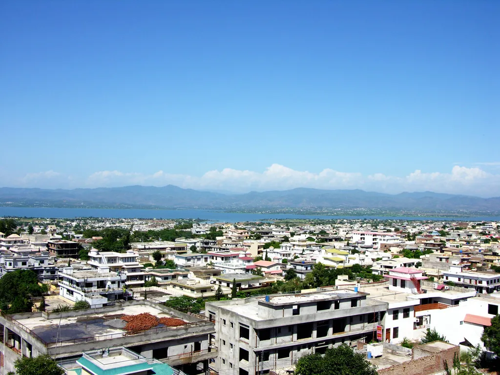
Photo: Geezer hd1, with thanks · CC BY-SA 3.0 · via Wikimedia Commons · temporary stand-in photo

Mirpur
District capital of Mirpur in Azad Kashmir, nicknamed Little England for its British Pakistani links, beside Mangla Dam.
Overview
Mirpur is the capital of Mirpur District in Azad Kashmir, at the foothills of the Himalayas. It is the second-largest city in Azad Kashmir. Wikipedia gives 124,352 people at the 2017 census and has no 2023 figure. About 85% of the district speaks Pahari-Pothwari, a western Punjabi variety, and about 10% speak Gojri. Urdu is the official language, and English is widely used in schools and colleges.
Plan your visit
- Getting there
Road: Islamabad International Airport is about 130 km away and Sialkot International Airport about 110 km (Wikipedia). Bus: services run to Gujrat, Jhelum, Lahore and Rawalpindi. More
Best months
Oct – Apr
- Mirpur
- Related places nearby: Mangla Dam, Jhelum
History
Tradition dates the city to around 1640, founded under Mughal rule by the Ghakhar chief Miran Shah Ghazi. It later became part of Chibb territory and then came under Sikh control under Ranjit Singh. The 1846 Treaty of Amritsar transferred the area to Gulab Singh of Jammu. Mirpur was historically a boat-building centre for river trade on the Jhelum, a trade that declined when the British built railways. In the 1947-48 war the town was captured by local rebels and tribal forces, and it joined Azad Kashmir. Before 1947 the district had about 75,000 Hindus and Sikhs. Wikipedia's account of the violence of that time is flagged as disputed, so it is not repeated here.
Mangla Dam and the diaspora
Raising Mangla Dam displaced many families. A relief package included a new city on Mirpur's south-eastern outskirts and four planned resettlement towns, and the old city is also being expanded. Many people from the area moved to the United Kingdom in the late 1950s and early 1960s, so the city is nicknamed Little England and Little Britain. Wikipedia says many shops sell British products and some accept pound sterling. Birmingham, Bradford and Waltham Forest in London are friendship cities. Overseas families often return in summer.
Climate and daily life
The climate is humid subtropical. June is the hottest month, with a mean daily maximum of 41.0 C. Monsoon rain peaks in July and August, and annual rainfall is about 1,380 mm. January is the coolest month, with a mean daily minimum of about 3.9 C. Auto rickshaws are the usual way to get around town. Industries listed include textiles, ready-made garments, marble, ghee, sawmills and motorbike assembly. Football, cricket and volleyball are popular, and Quaid-e-Azam Stadium is the city's cricket ground.
What to see and do
- Mangla Dam: see the Mangla Dam page.
- Ramkot Fort: see Ramkot Fort.
- Khari Sharif Darbar: a shrine listed by Wikipedia among the area's attractions. The Sufi poet Mian Muhammad Bakhsh and the saint Baba Shadi Shaheed are among the area's notable figures named by Wikipedia.
- Mangla Fort: also listed by Wikipedia. No opening details are documented for any of these sites.
When to visit
October to April is more comfortable. Summers on the plains edge are hot.
Where to stay and eat
No hotel or restaurant names are documented. Ask locally.
Getting around
There is no railway station in Mirpur; the nearest is at Dina. Buses link the city with Bhimber, Kotli and Dadyal, and with Gujrat, Jhelum, Lahore and Rawalpindi.
Good to know
For foreign visitors: the UK FCDO Pakistan page (updated 27 October 2026, checked 17 November 2026) advises against all but essential travel to Azad Jammu and Kashmir, and against all travel within 10 miles of the Line of Control. The page does not name Mirpur, so check the current text and ask local authorities about any restrictions before you go.
Highlights
- Capital of Mirpur District in Azad Kashmir
- Beside Mangla Dam
- Nicknamed Little England for its UK links
- Ramkot Fort and Mangla Fort nearby
Getting there
Road: Islamabad International Airport is about 130 km away and Sialkot International Airport about 110 km (Wikipedia). Bus: services run to Gujrat, Jhelum, Lahore and Rawalpindi. Rail: there is no railway station in Mirpur. The nearest is at Dina. Air: an international airport was approved in 2013 but has not been built.
Hotels, food, fuel and services in Mirpur
Places to stay
- Mun O Salwa RestaurantCall Mun O Salwa RestaurantMap of Mun O Salwa Restaurant in Google Maps
- MIAN SAHIB PLAZA & HOSTELMap of MIAN SAHIB PLAZA & HOSTEL in Google Maps
- Kashmir HotelMap of Kashmir Hotel in Google Maps
Places to eat
- Nafees Bakers & Restaurant(Mian Muhammad Road)Call Nafees Bakers & Restaurant(Mian Muhammad Road)Map of Nafees Bakers & Restaurant(Mian Muhammad Road) in Google Maps
- Roopyal Hotel & RestaurantCall Roopyal Hotel & RestaurantMap of Roopyal Hotel & Restaurant in Google Maps
- Smokin' GrillCall Smokin' GrillMap of Smokin' Grill in Google Maps
- Ajwa Bakers & Restaurant MirpurCall Ajwa Bakers & Restaurant MirpurMap of Ajwa Bakers & Restaurant Mirpur in Google Maps
- Millat RestaurantCall Millat RestaurantMap of Millat Restaurant in Google Maps
- Valley RestaurantCall Valley RestaurantMap of Valley Restaurant in Google Maps
Essential services fuel stations, mechanics, ATMs, pharmacies and hospitals and clinics
Fuel
- Al Manzoor PSO Fuel StationMap of Al Manzoor PSO Fuel Station in Google Maps
- PSO Petrol StationCall PSO Petrol StationMap of PSO Petrol Station in Google Maps
- AdmoreMap of Admore in Google Maps
- Petrol PumpMap of Petrol Pump in Google Maps
- Hascol (kashmir Associates)Map of Hascol (kashmir Associates) in Google Maps
Mechanics and tyre shops
- Ashiq Suzuki CenterCall Ashiq Suzuki CenterMap of Ashiq Suzuki Center in Google Maps
- CAR StudioCall CAR StudioMap of CAR Studio in Google Maps
- Ahmed Auto Wholesale dealershipCall Ahmed Auto Wholesale dealershipMap of Ahmed Auto Wholesale dealership in Google Maps
- Rajco Tyre ShopMap of Rajco Tyre Shop in Google Maps
- Pakistan Tyre and Digital AlignmentCall Pakistan Tyre and Digital AlignmentMap of Pakistan Tyre and Digital Alignment in Google Maps
- Khan Tyre Works Mirpur (AJK)Call Khan Tyre Works Mirpur (AJK)Map of Khan Tyre Works Mirpur (AJK) in Google Maps
ATMs
- ATM - HBL Kalyal MirpurMap of ATM - HBL Kalyal Mirpur in Google Maps
- Askari BankCall Askari BankMap of Askari Bank in Google Maps
Pharmacies
- Madina MedicinesCall Madina MedicinesMap of Madina Medicines in Google Maps
- Shaheen Chemist & CosmeticsCall Shaheen Chemist & CosmeticsMap of Shaheen Chemist & Cosmetics in Google Maps
- Medbros PharmacyCall Medbros PharmacyMap of Medbros Pharmacy in Google Maps
- Amin PharmcyCall Amin PharmcyMap of Amin Pharmcy in Google Maps
- Zia Sons Medical StoreCall Zia Sons Medical StoreMap of Zia Sons Medical Store in Google Maps
- United Medical HallCall United Medical HallMap of United Medical Hall in Google Maps
Hospitals and clinics
- Pet&pat mirpur ajk#pet clinic #pet shop#animal hospitalCall Pet&pat mirpur ajk#pet clinic #pet shop#animal hospitalMap of Pet&pat mirpur ajk#pet clinic #pet shop#animal hospital in Google Maps
- Mother & Child International HospitalCall Mother & Child International HospitalMap of Mother & Child International Hospital in Google Maps
- Mohi Ud Din Teaching Hospital (MOTH), Mirpur AJKMap of Mohi Ud Din Teaching Hospital (MOTH), Mirpur AJK in Google Maps
- City HospitalCall City HospitalMap of City Hospital in Google Maps
- Akram Eye HospitalCall Akram Eye HospitalMap of Akram Eye Hospital in Google Maps
- Mirza Abdul Qayyum Memorial HospitalCall Mirza Abdul Qayyum Memorial HospitalMap of Mirza Abdul Qayyum Memorial Hospital in Google Maps
Listings come from Google Maps data and are unverified: phone numbers, opening months and prices may have changed. Report a problem · Own one of these? Claim it
Tips
- Read the FCDO advice for Azad Kashmir before planning a trip.
- Allow time for security checks and ask locally about access to Mangla Dam.
- Visit between October and April to avoid the worst heat.
Photos we still need: Mangla Dam lake or the new Mirpur skyline; Ramkot Fort or Khari Sharif. Send us yours
Sources and last checked
Last checked Confidence low2 sources4 still to check
- Last checked
- Method
- Desk research from published sources
- Confidence
- low
- Checked by
- trek.pk research team
Researched from published sources; not yet checked on the ground by our team. Spot something out of date? Report a mistake.
Sources
- Mirpur, Azad Kashmir · Wikipedia · checked
- Pakistan travel advice: warnings and insurance · UK FCDO (GOV.UK) · checked
Still to be checked on the ground (4)
- 2023 census population (only the 2017 figure of 124,352 found)
- Public access to Mangla Dam, Mangla Fort and Ramkot Fort
- Hotels and services
- Whether FCDO's Azad Kashmir advice applies in the same way to Mirpur (not named)
Nearby and related

Mangla Dam
A large embankment dam on the Jhelum River, completed in 1967 and raised in 2009. The lake has a recreation side open to the public, but parts of the area are restricted.

Ramkot Fort
A hilltop fort of uncertain age on a peninsula in Mangla Lake near Mirpur, Azad Kashmir. It is reached by boat or a steep climb of 440 steps to the main gate.

Jhelum
Grand Trunk Road city on the Jhelum River, 23 km from Rohtas Fort (UNESCO), about 30 km from Mangla Dam and about 116 km from Islamabad.

Muzaffarabad
The capital of Azad Jammu and Kashmir, at 737 m where the Neelum and Jhelum rivers meet. It is the gateway to the Neelum Valley and a rebuilt city after the 2005 earthquake.

Islamabad
Pakistan's green, planned capital at the foot of the Margalla Hills: Faisal Mosque, hillside trails, cafes and the gateway to the north.