

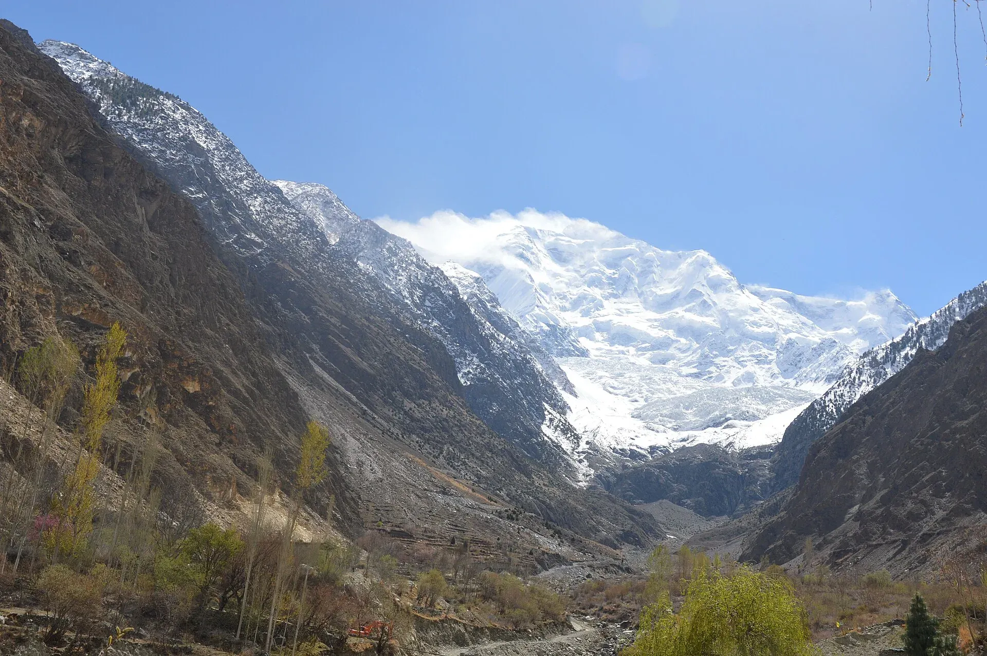
Photo: Maria.khanum1983, with thanks · CC BY-SA 4.0 · via Wikimedia Commons · temporary stand-in photo

Rakaposhi View Point
A roadside stop on the Karakoram Highway at Ghulmet in Nagar, about 60 km from Gilgit, with a close view of Rakaposhi (7,788 m) rising above the Hunza River.
Overview
The Rakaposhi View Point is beside the Karakoram Highway (KKH) at Ghulmet in Nagar, on the road from Gilgit to Hunza. Wikipedia calls it the "Zero Point of Rakaposhi" and says it is the closest viewpoint to the mountain. The Government of Pakistan's Nagar tourist sheet places it 60 km from Gilgit, a drive of about an hour by car or jeep.
Plan your visit
- Nearest town
- Ghulmet
- Getting there
On the Karakoram Highway (N-35), about 60 km from Gilgit, 1 hour by car or jeep (Government of Pakistan Nagar tourist sheet). Buses and shared vans between Gilgit and Hunza pass the viewpoint; ask the driver to stop. More
Best months
Apr – Jun, Sep – Oct
The mountain
Rakaposhi is 7,788 m high, the 27th highest mountain in the world, between the Nagar and Bagrot valleys. Wikipedia says it rises about 5,900 m above the Hunza River over a horizontal distance of only 11.2 km. It is also called Dumani, "Mother of Mist" or "Mother of Clouds"; its Burushaski name is often glossed as "Shining Wall". Mike Banks and Tom Patey of a British expedition made the first ascent in 1958 by the south-west spur, and it was over 20 years before another team reached the summit, in 1979.
What to see and do
From the viewpoint you see the mountain from low down, with the river and fields at its foot. Diran (7,266 m), east of Rakaposhi, can be seen from other points on this side of the valley. This stop needs no walking at all.
For a closer look, the Rakaposhi Base Camp trek starts from Minapin, further along the road; see Rakaposhi Base Camp. The Minapin Glacier is nearby.
Along the road
The viewpoint is one stop on the Nagar Valley side of the Hunza River. The Hunza-Nagar valley's main communities are Burusho and Shina speakers, and most residents are Ismaili Shia (Wikipedia). Marble is mined at Pisan and Minapin, and Nilt, further up the valley, was the site of the 1891 Anglo-Brusho war and has old forts.
When to visit
Mornings are usually clearer, before cloud builds on the high faces (general advice, not a forecast). Spring and autumn often give the cleanest air, while summer haze can flatten the view. In winter, check road conditions before you travel.
Where to stay and eat
Travel listings mention a small café and hotel at or near the viewpoint. The current operators are not confirmed, so treat this as unconfirmed. Gilgit and Karimabad have the main choice of rooms.
Good to know
- Altitude: Not confirmed for the viewpoint itself; the peak is 7,788 m.
- Safety: The highway is busy with trucks. Park fully off the road. Rockfall can close the KKH after rain or snow.
- Travel advice: For foreign visitors: the UK FCDO does not advise against Gilgit-Baltistan generally but does advise against the KKH between Mansehra and Chilas (updated 27 October 2026). Check the live page.
Highlights
- Closest roadside view of Rakaposhi (7,788 m)
- About one hour from Gilgit
- A 5,900 m rise above the Hunza River over 11.2 km
- Easy stop on the way to Hunza
Getting there
On the Karakoram Highway (N-35), about 60 km from Gilgit, 1 hour by car or jeep (Government of Pakistan Nagar tourist sheet). Buses and shared vans between Gilgit and Hunza pass the viewpoint; ask the driver to stop.
Tips
- Stop on the way up to Hunza in the morning, when the sky is clearer.
- Park off the carriageway; this is a busy truck road.
- Bring a zoom lens or binoculars for the upper faces.
- Ask locally before driving on to Minapin for the base camp trek.
Facilities
- Roadside stop
- Small café reported (unconfirmed)
Photos we still need: Rakaposhi from the viewpoint in clear light; the Hunza River and fields below. Send us yours
Sources and last checked
Last checked Confidence medium5 sources2 still to check
- Last checked
- Method
- Desk research from published sources
- Confidence
- medium
- Checked by
- trek.pk research team
Researched from published sources; not yet checked on the ground by our team. Spot something out of date? Report a mistake.
Sources
- District Nagar tourist guide and map · Government of Pakistan tourism portal · checked
- Rakaposhi (Wikipedia) · Wikipedia · checked
- Diran (Wikipedia) · Wikipedia · checked
- Pakistan travel advice: warnings and insurance (updated 27 October 2026) · UK Foreign, Commonwealth & Development Office · checked
- Hunza Valley (Nagar Valley) · Wikipedia · checked
Still to be checked on the ground (2)
- Viewpoint altitude and exact coordinates (not in Wikipedia or the tourism sheet; Nominatim returned no result for the viewpoint or Ghulmet, so no location added)
- Current café or hotel operators (no source)
Nearby and related

Rakaposhi Base Camp

Rakaposhi
Rakaposhi (7,788 m) rises above the Hunza and Nagar valleys north of Gilgit. It can be seen from the KKH and Karimabad, and open-zone treks lead to Tagaphari and Diran Base Camp.
Diran
Diran (7,266 m) is a pyramid-shaped peak in the Bagrot Valley, east of Rakaposhi. It was first climbed in 1968 and is seen from Karimabad, Minapin and the open-zone Diran Base Camp trek.

Nagar Valley
The quieter bank of the Hunza River, facing Karimabad: Minapin, Hoper and Hispar villages, Rakaposhi viewpoints and easy treks below Rakaposhi, Diran and Spantik.
Minapin Glacier
The glacier that sweeps down from the Rakaposhi-Diran ridge above Minapin village in Nagar. An easy three-day trek to Tagaphari looks across it, and Diran Base Camp lies over its upper ice.

Gilgit
Gateway to Gilgit-Baltistan on the Karakoram Highway: a busy mountain town with the Kargah Buddha and the base for Hunza, Naltar and Skardu.

Hunza River
The river that runs beside the Karakoram Highway through Gojal, Hunza and Nagar before joining the Gilgit River. It formed Attabad Lake in 2010, when a landslide blocked it.

Hunza and Khunjerab (KKH)
A 7-8 day road trip from Islamabad up the Karakoram Highway to Hunza and on to Khunjerab Pass (4,693 m), with overnight stops at Besham, Chilas and Gilgit.