

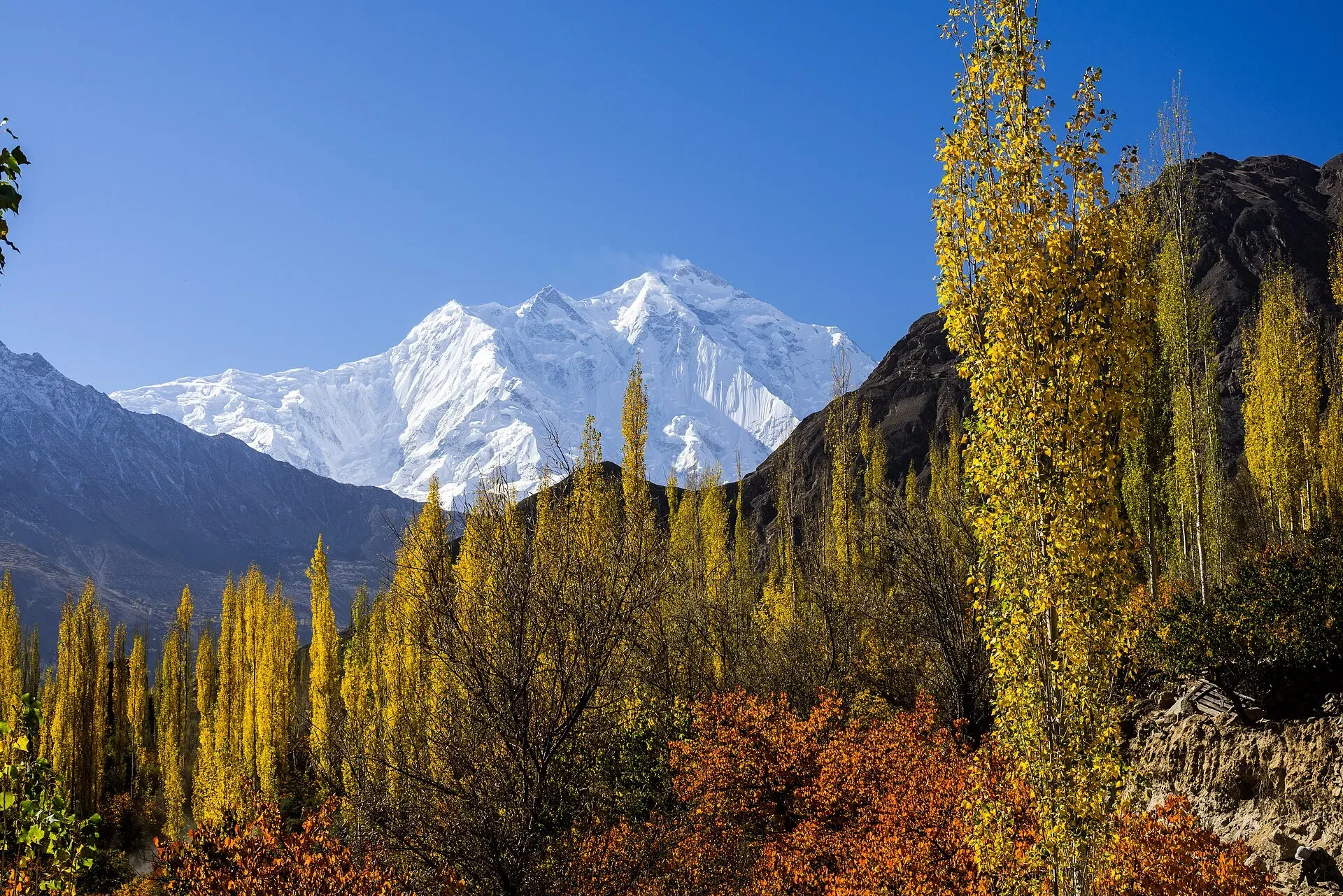
Photo: mhtoori, with thanks · CC BY-SA 4.0 · via Wikimedia Commons · temporary stand-in photo

Rakaposhi
Rakaposhi (7,788 m) rises above the Hunza and Nagar valleys north of Gilgit. It can be seen from the KKH and Karimabad, and open-zone treks lead to Tagaphari and Diran Base Camp.
Overview
Rakaposhi is a 7,788 m peak in the Karakoram, between the Nagar and Bagrot valleys in Gilgit-Baltistan. It is the 27th-highest mountain in the world. The summit ridge is broad, almost 20 km from east to west, and Wikipedia describes it as the only peak that descends almost without interruption about 6,000 m to its base. On the north it rises 5,900 m above the Hunza River in only 11.2 km. Locals also call it Dumani, "mother of mist".
Plan your visit
- Nearest town
- Minapin
- Getting there
Drive on the KKH from Gilgit towards Hunza; Minapin is the start of the Rakaposhi Base Camp trek, and Chirah in the Bagrot Valley is the start for Diran. Both are a short jeep or road trip from Gilgit. More
Best months
Jun – Sep
- Rakaposhi
- Related places nearby: Nagar Valley, Bagrot Valley, Karimabad (Hunza), Hunza Valley, Gilgit, Tagaphari (Rakaposhi Base Camp)
Name
In Burushaski, the language of Hunza and Nagar, the name is given as "Shining Wall". Locals also use Dumani, "mother of mist" (or "mother of clouds").
Early attempts and first ascent
Martin Conway explored the south side in 1892. In 1938 M. Vyvyan and R. Campbell Secord made the first reconnaissance and climbed a north-west forepeak of about 5,800 m. Secord came back in 1947 with H. W. Tilman and the Swiss climbers Hans Gyr and Robert Kappeler. A Cambridge team led by Alfred Tissieres reached 6,340 m in 1954, and a British-American expedition led by Mike Banks reached 7,163 m in 1956.
Banks and Tom Patey made the first ascent on 25 June 1958, by the south-west spur. Both suffered minor frostbite. It was more than 20 years before the next success.
Later ascents
In 1979 two teams reached the top. A Japanese team from Waseda University, led by Eiho Ohtani, climbed the north spur, and a Polish-Pakistani expedition climbed the north-west ridge. In 1984 a Canadian team (Barry Blanchard, David Cheesmond and Kevin Doyle) climbed the north spur in semi-alpine style. Later ascents include a Dutch variation of the north-west ridge in 1986, and Japanese climbers Kazuya Hiraide and Kenro Nakajima in 2019. Pakistani climber Wajidullah Nagari reached the summit in 2021 with two Czech climbers.
Glaciers and approaches
Climbing parties have used several glaciers. The Gunti glacier was the approach for the south-west spur in 1947 and 1956. The Biro glacier led the 1979 Polish-Pakistani team to the north-west ridge. From the Bagrot side, attempts in 2000, 2002 and 2004 were based on the Hinarche (Hinercha) glacier. Tagaphari (Taghafari) is the base camp on the Nagar side.
What to see and do
- Viewpoints: the peak is visible from the KKH through Nagar and from Karimabad. The "Zero Point of Rakaposhi" at Ghulmet is the closest roadside viewpoint, according to Wikipedia.
- Rakaposhi Base Camp trek: from Minapin to Tagaphari (about 3,260 m), a 3-day walk with a 1,250 m climb, facing the ice ridge to Diran.
- Diran Base Camp trek: from Chirah in the Bagrot Valley to Hinarche Harai (about 4,000 m), under the south wall of the Rakaposhi-Diran ridge.
- Hon Pass: a viewpoint above Ultar Meadow with an aerial view of Rakaposhi and Diran.
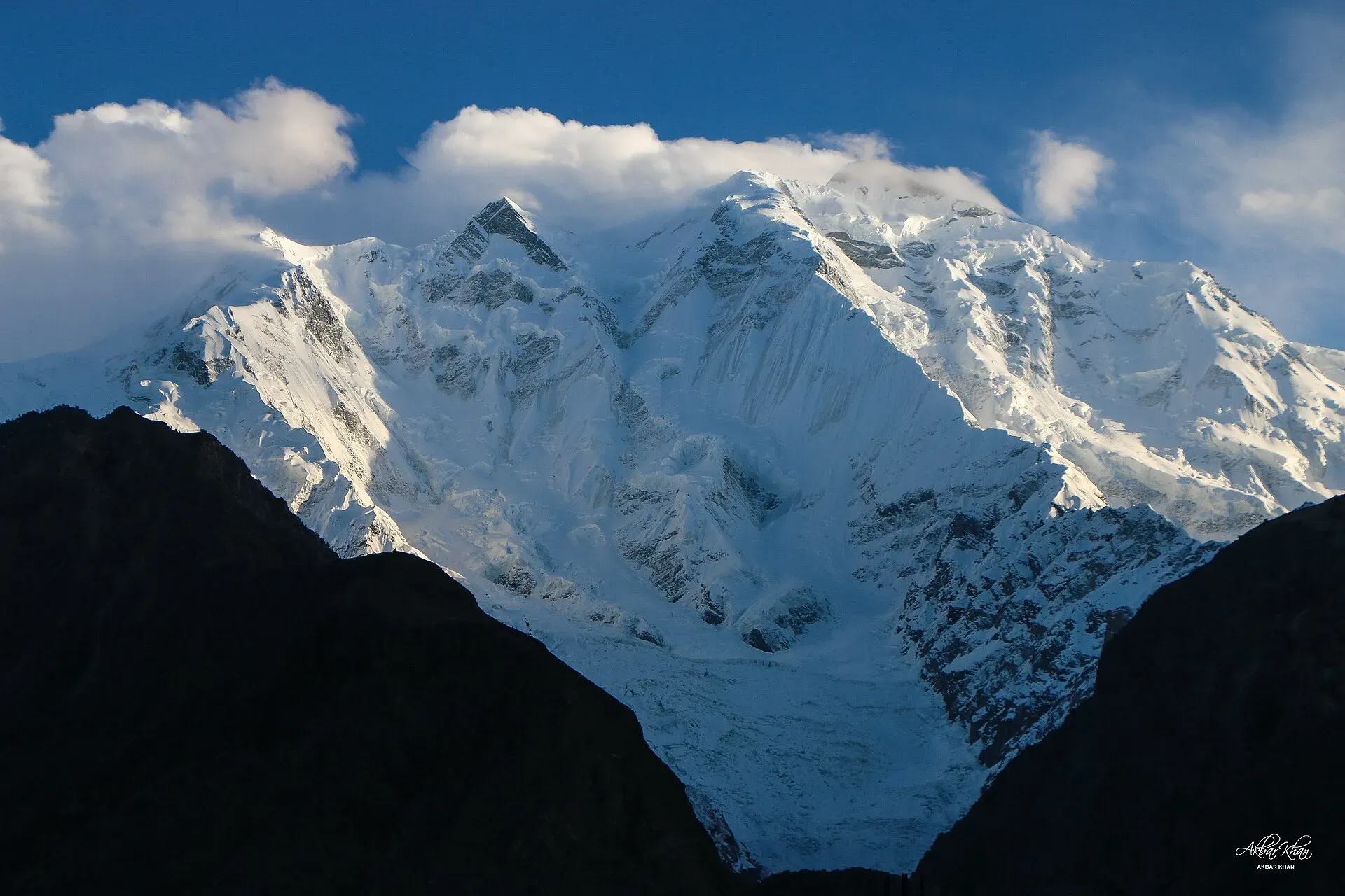
Photo: Akbar Khan Niazi, with thanks · CC BY-SA 4.0 · via Wikimedia Commons · temporary stand-in photo

When to visit
Both base camp treks are listed for June to September. Early and late in that window you may meet snow on the ridge, and nights at Tagaphari can fall below freezing.
Where to stay and eat
Karimabad, Minapin and Gilgit have guesthouses and hotels. Trek camps are simple, with huts and tents at Tagaphari.
Good to know
Climbing context. The standard route is long and not extremely technical, but it has tricky rock pinnacles. The other routes are harder. It is a serious mountaineering objective, not a trek.
Permits and royalty. Both base camp treks are in the open zone, where foreign visitors need no trekking permit (Dawn, 29 March 2026). Climbing the peak needs an expedition permit and royalty through a licensed operator. The royalty rules changed in 2024 and were challenged in court (Dawn, 1 March 2025). In May 2025 the Gilgit-Baltistan Tourism Department notified a reduced fee schedule after a cabinet decision (The News, 25 May 2025). No official schedule for 2026 was found, so current fees will be added soon; ask your operator for the written fee list.
Ask the district administration or local police about current conditions before you go. Getting there safely. For foreign visitors: the UK FCDO (updated 27 October 2026) advises against travel on the KKH between Mansehra and Chilas but does not advise against Gilgit-Baltistan as a whole. Ask your operator which route they use.
Highlights
- 27th-highest mountain, 7,788 m
- Rises about 5,900 m above the Hunza River in 11 km
- First climbed 25 June 1958
- Open-zone treks to Tagaphari and Diran Base Camp
Getting there
Drive on the KKH from Gilgit towards Hunza; Minapin is the start of the Rakaposhi Base Camp trek, and Chirah in the Bagrot Valley is the start for Diran. Both are a short jeep or road trip from Gilgit.
Tips
- The main summit is hidden behind Rakaposhi East (7,010 m) from Tagaphari.
- For Diran Base Camp, day 2 is long (10 to 12 hours) with a glacier crossing; take a guide.
- Ask locally which roadside stops have the clearest view on the day.
Photos we still need: Tagaphari camp and the Minapin side of Rakaposhi; Diran Base Camp or the Bagrot valley approach. Send us yours
Sources and last checked
Last checked Confidence medium7 sources4 still to check
- Last checked
- Method
- Desk research from published sources
- Confidence
- medium
- Checked by
- trek.pk research team
Researched from published sources; not yet checked on the ground by our team. Spot something out of date? Report a mistake.
Sources
- Rakaposhi (Wikipedia) · Wikipedia · checked
- List of mountains in Pakistan (heights and prominence) · Wikipedia · checked
- Gilgit-Baltistan tourism bounces back despite Middle East war (permit rules for open and restricted zones, 29 March 2026) · Dawn · checked
- Mountaineering royalty and trekking fee increase challenged in GB Chief Court (1 March 2025) · Dawn · checked
- Pakistan travel advice (updated 27 October 2026) · UK Foreign, Commonwealth and Development Office · checked
- Rakaposhi: ascent history, glaciers, name (article text) · Wikipedia (read again for this update) · checked
- GB slashes mountaineering, trekking fees to promote tourism (25 May 2025) · The News · checked
Still to be checked on the ground (4)
- Current royalty and trekking fee amounts (the GB Tourism Department notified a reduced schedule in May 2025 per The News; no official 2026 schedule found)
- District for the peak: Wikipedia's summary box gives Gilgit District, between the Nagar and Bagrot valleys; the page says Nagar (Minapin side). Confirm with the district notification
- Tagaphari height varies by source (3,260-3,500 m); Wikipedia gives no figure
- Spelling and altitude of the Hinarche (Hinercha) glacier camp
Nearby and related

Rakaposhi Base Camp

Diran Base Camp (Rakaposhi-Diran ridge, from Bagrot)

Ultar Meadow

Nagar Valley
The quieter bank of the Hunza River, facing Karimabad: Minapin, Hoper and Hispar villages, Rakaposhi viewpoints and easy treks below Rakaposhi, Diran and Spantik.
Bagrot Valley
A high valley about 30 km from Gilgit, running up to Rakaposhi and Diran, with farming villages, Gargo meadow and the open trek to Diran Base Camp from Chirah.
Minapin Glacier
The glacier that sweeps down from the Rakaposhi-Diran ridge above Minapin village in Nagar. An easy three-day trek to Tagaphari looks across it, and Diran Base Camp lies over its upper ice.

Karimabad (Hunza)
The main town of Hunza, set on a terrace below Baltit Fort with Rakaposhi, Ultar and Diran in view. A good base for forts, viewpoints, Attabad Lake and the road to Gojal.
Hunza Valley
A long Karakoram valley on the Karakoram Highway, with Karimabad, Baltit and Altit forts, Ganish village and Attabad Lake, below Rakaposhi and Ultar Sar. About 100 km from Gilgit.

Gilgit
Gateway to Gilgit-Baltistan on the Karakoram Highway: a busy mountain town with the Kargah Buddha and the base for Hunza, Naltar and Skardu.
Tagaphari (Rakaposhi Base Camp)
The meadow at the end of the Rakaposhi Base Camp trek above Minapin, about 3,260 m, facing the Rakaposhi-Diran ice ridge.