

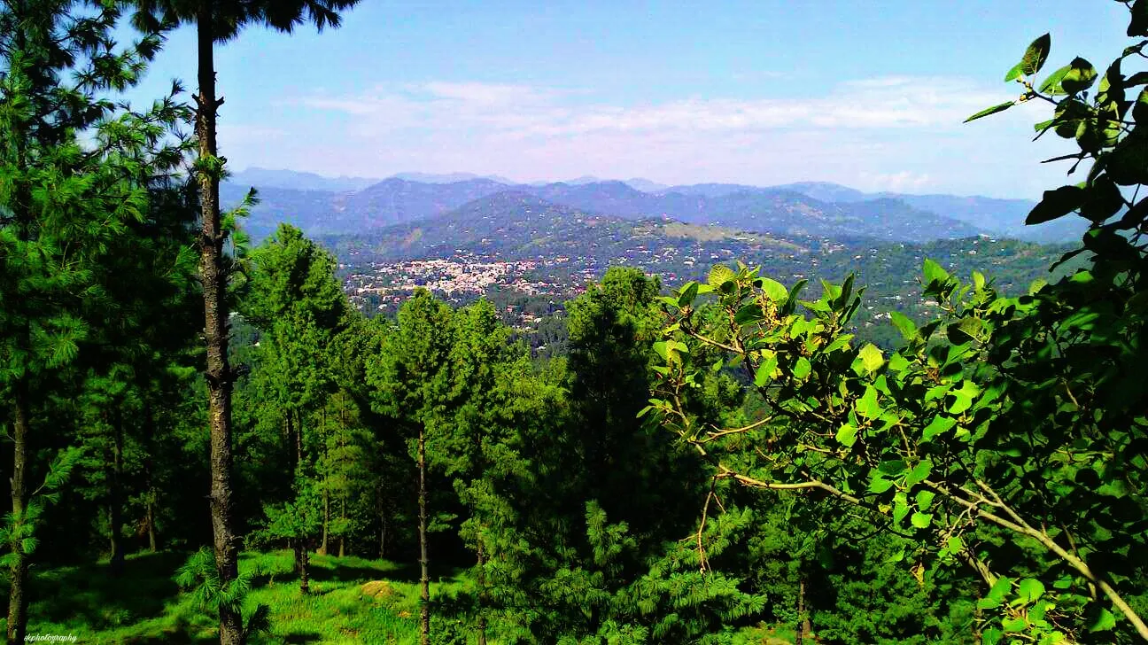
Photo: Saif qamar, with thanks · CC BY-SA 4.0 · via Wikimedia Commons · temporary stand-in photo

Rawalakot
The main town of Poonch district in Azad Kashmir, at about 1,640 m, and the usual base for Banjosa Lake and Toli Pir. Cool in summer, with snow in winter. FCDO advises against all but essential travel to AJK.
Overview
Rawalakot is the main town of Poonch District in the Poonch Division of Azad Jammu and Kashmir. Wikipedia gives its height as 1,638 m and its 2017 census population as 56,006. It has a subtropical highland climate: summer highs can reach 38 C, winter lows fall below -1 C, and snow falls in December and January. Average annual rainfall is about 508 mm, mostly from July to September.
The town is the base for visits to Banjosa Lake and the Toli Pir area. It is a working town, not a resort, and most visitors pass through on the way to the lake or the hills.
Plan your visit
- Getting there
About 120 km from Islamabad and Rawalpindi according to Wikipedia, and about 76 km from Kahuta. Mountain roads are slow; allow most of a day and check road conditions first. Banjosa Lake is about 18 km from the town. More
Best months
May – Oct
- Rawalakot
- Related places nearby: Azad Jammu and Kashmir, Bagh, Azad Kashmir, Toli Pir National Park, Banjosa Lake, Poonch River Mahseer National Park, Muzaffarabad, Sudhan Gali, Hajira, Palandri
History
Rawalakot and nearby Pallandri were the focal points of the 1955 Poonch uprising, led by local Sudhans, who opposed Sher Ahmed Khan and wanted Sardar Ibrahim Khan and democratic reforms. The town suffered heavy damage in the 8 October 2005 earthquake, which killed 73,338 people across Pakistan and left up to three million homeless. Most buildings stood but many were uninhabitable, and most have since been rebuilt.
People and language
Gujjars are a major ethnic group. Other groups in the district include Bakarwals, Kashmiris, Sayeds, Rajputs and Sudhans. Pahari (Rawalakoti), Gujari and Hindko are the main spoken languages. Urdu is the official language, and some people speak Kashmiri or Punjabi. The 2017 census gave an urban population of 56,006. The town has about 25 high schools, 5 degree colleges, a medical college and a university.
What to see and do
- Banjosa Lake. A reservoir in pine forest, about 18 km from Rawalakot on a paved road. See the Banjosa Lake page.
- Toli Pir. A hilltop and national park area near the town, with forest. See the Toli Pir National Park page. Wikivoyage calls the area very scenic.
- Poonch River. The Poonch River Mahseer National Park is on the river that flows through the district.
- The bazaar. Wikipedia also lists other places for visitors around Rawalakot: Thorar, Abaspur, Singola, Hajira, Devi Gali, Khai Gala, Ali Sojal, Horna Maira, Toli Pir and Datote. See Hajira. The sources opened give no sights inside the town itself.
When to visit
May to October is mild and suits the lake and hill walks. July to September brings most of the rain. Winter has snow and can close mountain roads.
Getting around and safety
Wikipedia lists the Ghazi-e-Millat road to Azad Pattan as the main link towards Islamabad and Rawalpindi, a road via Pakgali and Paniola towards Bagh and Muzaffarabad, and a road to Kotli. Rawalakot Airport has been closed since October 2005.
The 2005 earthquake damage is described under History above.
For foreign visitors: the UK FCDO (updated 27 October 2026, checked 17 November 2026) advises against all but essential travel to Azad Jammu and Kashmir, and against all travel within 10 miles of the Line of Control. It does not name Poonch, Rawalakot or Bagh. No source gives the distance from here to the Line of Control, so check the FCDO page and ask local officials before you go. The FCDO also notes that local authorities have advised visitors to avoid demonstrations. Wikivoyage lists Rawalakot among places where foreign tourists do not need an AJK permit, but this is a general travel-guide statement; confirm with the AJK Home Department before travelling.
Where to stay and eat
The Toli Pir National Park page notes that Rawalakot has hotels and restaurants. We do not list businesses; check current options locally.
Good to know
Carry your identity documents. Cash and mobile signal can be limited outside the town.
Highlights
- Main town of Poonch district at about 1,640 m
- Base for Banjosa Lake and Toli Pir
- Snow in December and January
- Cooler than the Punjab plains in summer
Getting there
About 120 km from Islamabad and Rawalpindi according to Wikipedia, and about 76 km from Kahuta. Mountain roads are slow; allow most of a day and check road conditions first. Banjosa Lake is about 18 km from the town.
Hotels, food, fuel and services in Rawalakot
Places to stay
- Rawalakot Tourism HotelCall Rawalakot Tourism HotelMap of Rawalakot Tourism Hotel in Google Maps
- Marjan HotelCall Marjan HotelMap of Marjan Hotel in Google Maps
- HotelCall HotelMap of Hotel in Google Maps
- Dream Valley ResortCall Dream Valley ResortMap of Dream Valley Resort in Google Maps
- Pearl International Hotel & RestaurantCall Pearl International Hotel & RestaurantMap of Pearl International Hotel & Restaurant in Google Maps
- Government Guest House Rawalakot راولاکوٹ سرکٹ ہاوسMap of Government Guest House Rawalakot راولاکوٹ سرکٹ ہاوس in Google Maps
Places to eat
- Sultania Bar B.Q & Pizza HutسلطانیہCall Sultania Bar B.Q & Pizza HutسلطانیہMap of Sultania Bar B.Q & Pizza Hutسلطانیہ in Google Maps
- Speedys Fast Food - RawalakotCall Speedys Fast Food - RawalakotMap of Speedys Fast Food - Rawalakot in Google Maps
- Anayat Bakers & SweetsCall Anayat Bakers & SweetsMap of Anayat Bakers & Sweets in Google Maps
- Downtown Rawalakot Cafe & RestaurantCall Downtown Rawalakot Cafe & RestaurantMap of Downtown Rawalakot Cafe & Restaurant in Google Maps
- The Ancient sip cafe & restaurant - Best restaurant in rawalakotCall The Ancient sip cafe & restaurant - Best restaurant in rawalakotMap of The Ancient sip cafe & restaurant - Best restaurant in rawalakot in Google Maps
- Hunger ClubCall Hunger ClubMap of Hunger Club in Google Maps
Essential services fuel stations, mechanics, ATMs, pharmacies and hospitals and clinics
Fuel
- PSO Petrol Pump Kharick RawalakotCall PSO Petrol Pump Kharick RawalakotMap of PSO Petrol Pump Kharick Rawalakot in Google Maps
- Azeem Petroleum - PSOCall Azeem Petroleum - PSOMap of Azeem Petroleum - PSO in Google Maps
- Petroleum Filling Station Mujahid-AbadMap of Petroleum Filling Station Mujahid-Abad in Google Maps
Mechanics and tyre shops
- Lahore Autos and Excise ServicesCall Lahore Autos and Excise ServicesMap of Lahore Autos and Excise Services in Google Maps
ATMs
Pharmacies
- Healthcare Pharmacy, Surgical & CosmeticsCall Healthcare Pharmacy, Surgical & CosmeticsMap of Healthcare Pharmacy, Surgical & Cosmetics in Google Maps
Hospitals and clinics
- CMH Rawlakot, Pakistan سی ایم ایچ راولاکوٹ، پاکستانCall CMH Rawlakot, Pakistan سی ایم ایچ راولاکوٹ، پاکستانMap of CMH Rawlakot, Pakistan سی ایم ایچ راولاکوٹ، پاکستان in Google Maps
- Rawal General & Dental Hospital RawalakotCall Rawal General & Dental Hospital RawalakotMap of Rawal General & Dental Hospital Rawalakot in Google Maps
- SPECIALIST CARE HOSPITALCall SPECIALIST CARE HOSPITALMap of SPECIALIST CARE HOSPITAL in Google Maps
- United Hospital, Rawlakot PakistanCall United Hospital, Rawlakot PakistanMap of United Hospital, Rawlakot Pakistan in Google Maps
- Ali Imran HospitalCall Ali Imran HospitalMap of Ali Imran Hospital in Google Maps
- Ali Firdous ClinicCall Ali Firdous ClinicMap of Ali Firdous Clinic in Google Maps
Listings come from Google Maps data and are unverified: phone numbers, opening months and prices may have changed. Report a problem · Own one of these? Claim it
Tips
- Check the FCDO warning for AJK before you plan a trip
- Carry identity papers
- Allow a full day from Islamabad by road
- Check weather in winter; mountain roads can close
Photos we still need: Rawalakot bazaar and street scenes. Send us yours
Sources and last checked
Last checked Confidence low3 sources4 still to check
- Last checked
- Method
- Desk research from published sources
- Confidence
- low
- Checked by
- trek.pk research team
Researched from published sources; not yet checked on the ground by our team. Spot something out of date? Report a mistake.
Sources
- Rawalakot Tehsil · Wikipedia · checked
- Azad Kashmir · Wikivoyage · checked
- Pakistan travel advice (updated 27 October 2026) · UK Foreign, Commonwealth & Development Office · checked
Still to be checked on the ground (4)
- Distance from Rawalakot to the Line of Control (not found in a source)
- Current permit rules for foreign visitors in Poonch
- Road conditions and travel time from Islamabad
- Hotel and transport options (not listed here)
Nearby and related

Azad Jammu and Kashmir
A green, hilly region in the Himalayan foothills: Muzaffarabad, the Neelum and Leepa valleys, lakes and waterfalls. Visit with local advice on permission and the Line of Control.

Bagh, Azad Kashmir
Bagh is the headquarters of Bagh District in Azad Kashmir, a mountain town in the Pir Panjal foothills and the base for Sudhan Gali and Ganga Choti. For foreign visitors: the UK FCDO advises against all but essential travel to AJK.
Toli Pir National Park
A rugged mountain park in the Rawalakot area of Azad Kashmir, rising from about 1,500 m to over 6,000 m by Wikipedia's account, with black bear and leopard.

Banjosa Lake
A man-made lake at about 1,980 m in a pine forest, 18 km from Rawalakot in Poonch. It is reached by a paved road and freezes in winter.
Poonch River Mahseer National Park
A river protected area along the Poonch River in Kotli, Poonch and Mirpur districts, Azad Kashmir, created in 2010 to protect the golden mahseer.

Muzaffarabad
The capital of Azad Jammu and Kashmir, at 737 m where the Neelum and Jhelum rivers meet. It is the gateway to the Neelum Valley and a rebuilt city after the 2005 earthquake.

Sudhan Gali
A small hill resort at about 2,100 m on the Bagh-Muzaffarabad road in Bagh District, Azad Kashmir, and the usual start for the Ganga Choti hike. Quiet and basic. For foreign visitors: the UK FCDO advises against all but essential travel to AJK.
Hajira
A market and transport town in Poonch District, Azad Kashmir, at about 966 m, close to the Line of Control. UK advice is against all but essential travel to AJK.
Palandri
The administrative centre of Sudhnoti District in Azad Kashmir, linked with the 1955 Poonch uprising. UK advice is against all but essential travel to AJK.