

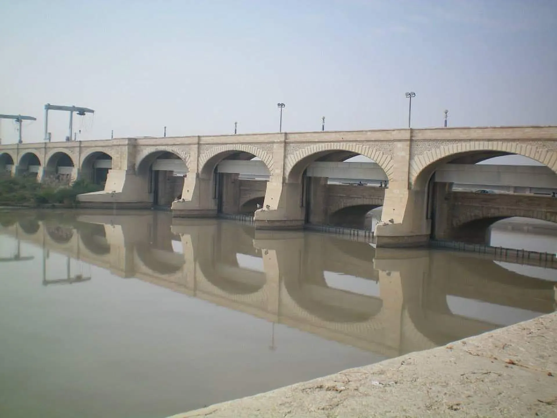
Photo: Ashahid83, with thanks · CC BY-SA 4.0 · via Wikimedia Commons · temporary stand-in photo

Sukkur Barrage (Lloyd Barrage)
A 1932 barrage across the Indus at Sukkur, originally named Lloyd Barrage. About 2 km long, it feeds seven canals and waters a large part of Sindh.
Overview
Sukkur Barrage crosses the Indus at Sukkur in Sindh, about 5 km below the Sukkur railway bridge (Wikipedia). It was sanctioned in 1923, built under British rule and opened in 1932 by the Viceroy, Lord Willingdon. It was first called Lloyd Barrage, after Sir George Lloyd, the Governor of Bombay. Sir Charlton Harrison was chief engineer.
Plan your visit
- Nearest town
- Sukkur
- Getting there
The barrage is at Sukkur on the Indus, a few kilometres from the city centre. Sukkur has rail and road links and an airport. Take a taxi or rickshaw from the city; no public transport to the barrage itself was found. More
Best months
Nov – Feb
- Sukkur Barrage (Lloyd Barrage)
- Related places nearby: Sukkur, Bukkur Island, Indus Dolphin Reserve (Sukkur-Guddu), Larkana
How it was built
C. A. Fife first proposed the scheme in 1868 (Wikipedia). It was sanctioned in 1923 and built from 1923 to 1932. Sir Arnold Musto is named as architect and engineer of the scheme, with Sir Charlton Harrison as chief engineer. Pakistan's army engineers and the Frontier Works Organisation began a major rehabilitation on 22 November 2004 and finished in July 2005, at a cost of US$15 million. A plaque from the Lloyd Barrage period survives at the site.
What to see and do
- The barrage. About 2 km long, with a spillway capacity of 1.15 million cusecs. Wikipedia gives 66 gated spans, each about 18 m wide, though that figure is marked as needing a source. It was rehabilitated by the army engineers and the Frontier Works Organisation, finishing in July 2005.
- The canals. It fed seven canals at first, about 10,417 km in all. Together they irrigate about 7.6 million acres, around a quarter of Pakistan's canal-irrigated land. The Nara Canal is the longest in the country and carries a discharge that Wikipedia likens to the River Thames at London. The Rohri Canal is second, serving cotton, wheat and sugarcane land. The Rice Canal on the right bank runs only in the kharif (summer crop) season. Water from the barrage reaches as far south as Tharparkar and Hyderabad districts.
- River views. The barrage sits close to the old town and to Bukkur Island, so it combines well with a short stay in Sukkur. See the Sukkur page.
- Dolphins. Indus river dolphins are usually seen upstream (Wikipedia). See the Indus Dolphin Reserve page.
When to visit
November to February is cooler. Summers are very hot.
Photography and safety
It is working irrigation infrastructure. Photography may be restricted; follow signs and police instructions.
Good to know
- Travel advice. For foreign visitors: the UK FCDO (updated 27 October 2026, checked 17 November 2026) advises against all but essential travel to Sindh north of and including Nawabshah, which includes Sukkur. Read the live page before planning.
- Access. No official visitor information was found for the barrage.
Highlights
- Opened in 1932 as Lloyd Barrage
- About 2 km long with 66 gated spans
- Feeds seven canals
- Irrigates about 7.6 million acres
Getting there
The barrage is at Sukkur on the Indus, a few kilometres from the city centre. Sukkur has rail and road links and an airport. Take a taxi or rickshaw from the city; no public transport to the barrage itself was found.
Tips
- Photography may be restricted; follow signs and police instructions.
- Visit in winter; summers are very hot.
- Read the FCDO advice before travelling to northern Sindh.
Photos we still need: the canal head regulators and the Indus dolphin habitat upstream. Send us yours
Sources and last checked
Last checked Confidence low2 sources3 still to check
- Last checked
- Method
- Desk research from published sources
- Confidence
- low
- Checked by
- trek.pk research team
Researched from published sources; not yet checked on the ground by our team. Spot something out of date? Report a mistake.
Sources
- Sukkur Barrage · Wikipedia · checked
- Foreign travel advice: Pakistan · UK FCDO · checked
Still to be checked on the ground (3)
- Visitor access, opening hours and photography rules
- Road distance and transport from Sukkur city centre
- Current FCDO advice for Sukkur before publishing
Nearby and related

Sukkur
Sindh's third-largest city on the Indus, with the 1932 Sukkur Barrage, the 1889 Lansdowne Bridge, Masum Shah's Minaret and the river islands of Rohri.

Bukkur Island
A limestone island fort in the Indus between Sukkur and Rohri, about 730 m long. Interior access is limited; most visitors view it from the bridges and riverbanks.

Indus River
Pakistan's greatest river, rising in Tibet and running about 3,180 km to the Arabian Sea. It crosses Gilgit-Baltistan, meets the Gilgit near Jaglot and the Kabul at Attock, and feeds the plains from Tarbela to the delta.
Indus Dolphin Reserve (Sukkur-Guddu)
A river reserve on the Indus in northern Sindh between Guddu and Sukkur barrages, declared in 1974 and Ramsar site no. 1065 since 2001. Home to the largest group of the Endangered Indus river dolphin. Security advice applies.
Guddu Barrage
An Indus barrage near Kashmore on the Sindh-Punjab border, finished in 1962. It feeds four canals, cools a thermal power station and carries a road across the river.

Larkana
A rice-growing city in northern Sindh and the base for Mohenjo-daro, the UNESCO-listed Indus Valley city about 30 km away, with the Bhutto family mausoleum nearby.