

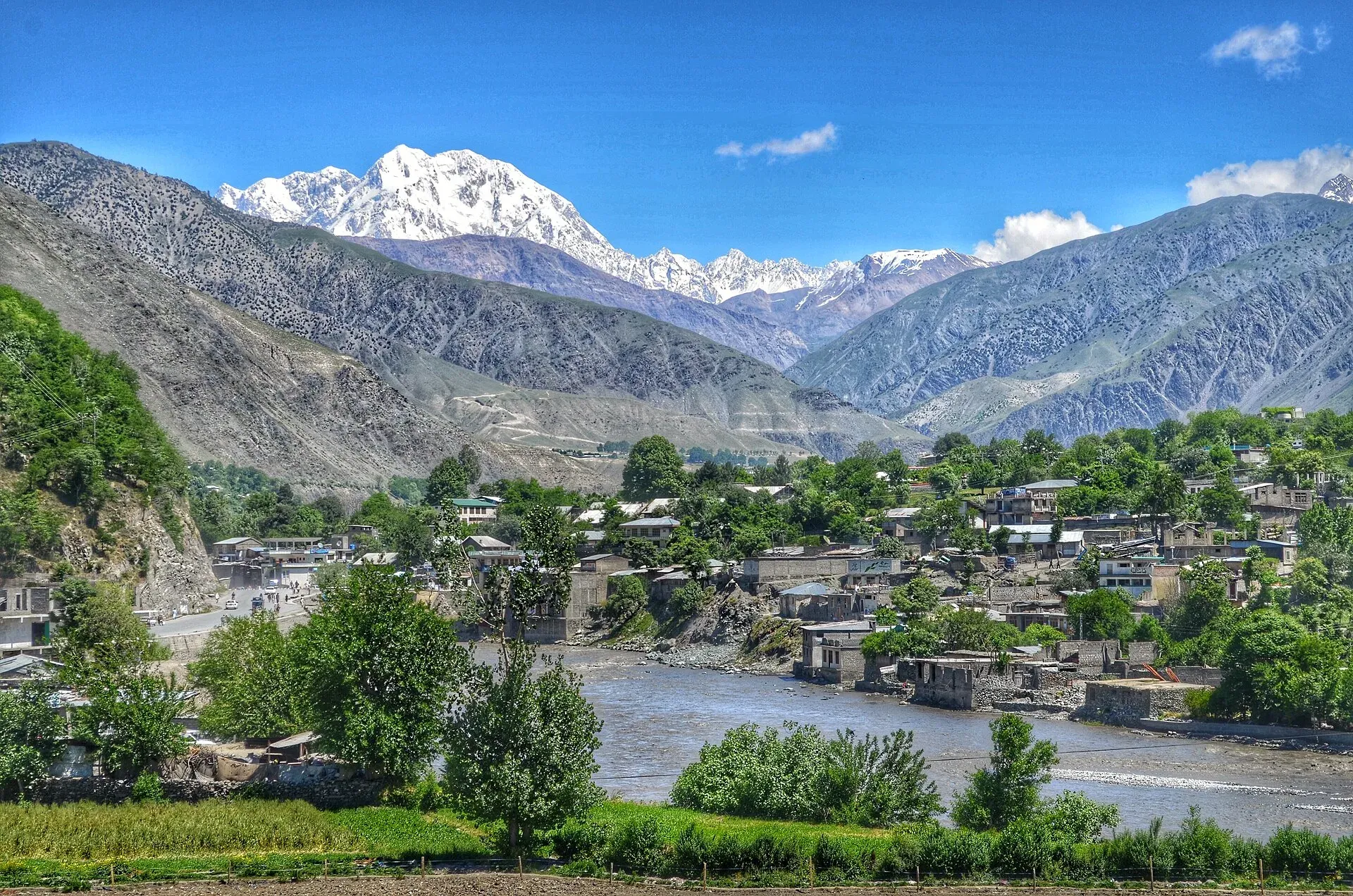
Photo: Emaad Paracha, with thanks · CC BY-SA 4.0 · via Wikimedia Commons · temporary stand-in photo

Tirich Mir View (Chitral)
Tirich Mir (7,708 m), the highest peak of the Hindu Kush, overlooks Chitral town and can be seen from the main bazaar and from rooftops in clear weather. No single official viewpoint.
Overview
Tirich Mir is 7,708 m high, the highest mountain in the Hindu Kush and the highest outside the Himalaya-Karakoram, ranked 33rd in the world. It overlooks Chitral town and can easily be seen from the main bazaar. This page is about seeing it from the town. No official, signed viewpoint is confirmed, so views depend on where you stand and on the weather.
Plan your visit
- Nearest town
- Chitral
- Getting there
By road from Dir through the Lowari Tunnel (N-45), about 99 km (OSRM about 1 h 10, optimistic); from Peshawar about 342 km (allow a day). By air from Islamabad when weather allows. More
Best months
May – Oct
- Tirich Mir View (Chitral)
- Related places nearby: Tirich Mir, Chitral, Chitral Valley, Chitral Fort (Shahi Qila)
The mountain
"Mir" means mountain in Khowar, the main language of Chitral. The peak is mostly mid-Cretaceous granite. The Tirich Glacier at the head of the Tirich valley is ringed by Tirich Mir, Noshaq and Istor-o-Nal, and its meltwater feeds the Torkhow River, a major tributary of the Chitral River. A Norwegian-British expedition made the first recorded ascent on 21 July 1950, by the south ridge. A Czechoslovak expedition opened the route now treated as the normal one in 1967.
Local belief gives the mountain a place in tradition: the neighbouring Kalash people associate it with the goddess Krumai, and Chitrali people believe it is home to fairies who forbid climbing.
What to see and do
Walk the bazaar and look up for the high white mass above the town. Hotel rooftops and upper floors give a wider view; ask the owner's permission first. Chitral Fort and the Shahi Mosque area are in town and are worth visiting, although a clear view of the peak from them is not confirmed. For a closer approach, the Tirich Mir Base Camp trek starts from Shagrom, up the Tirich valley, which is a mountaineering trip rather than a viewpoint stop.
Chitral town
Chitral, whose name means "field" in Khowar, has been a capital since the Katur dynasty made it the seat of its kingdom in 1571. In 1895 the British garrison in Chitral Fort was besieged. The town acceded to Pakistan in 1947. It has a dry Mediterranean climate, with very hot summers and almost no summer rain; winter snowfall of up to 60 cm in town is common. See the Chitral page.
When to visit
Clear mornings give the best views, and the peak is often hidden by cloud or haze later in the day (general advice). Chitral's usual visiting months run from May to October.
Where to stay and eat
Chitral has hotels and guesthouses in the bazaar area. Ask at reception about rooftop access.
Good to know
- Altitude: Chitral town is at about 1,500 m. The summit is 7,708 m.
- Getting there: From Dir about 99 km through the Lowari Tunnel (OSRM about 1 h 10, optimistic). Flights from Islamabad run when the weather allows.
- Ask the district administration or local police about current conditions before you go. Travel advice: For foreign visitors: the UK FCDO (updated 27 October 2026, checked 16 November 2026) advises against all travel on the N-45 highway to the edge of Chitral city, including the Kalash valleys. It also notes KP emergency measures and Governor's Rule since 11 October 2026. Check the live page before any plan involving Chitral, and ask KP Tourism about current road and security conditions.
Highlights
- Tirich Mir (7,708 m), highest peak of the Hindu Kush
- View from Chitral's main bazaar
- Rooftop views in clear weather
Getting there
By road from Dir through the Lowari Tunnel (N-45), about 99 km (OSRM about 1 h 10, optimistic); from Peshawar about 342 km (allow a day). By air from Islamabad when weather allows. See the FCDO note above before planning.
Tips
- Check the weather; clear mornings are best.
- Ask hotel staff for rooftop access.
- Read the FCDO page and local advice before travelling.
- Allow weather days if you fly; Chitral flights are often delayed.
Facilities
- Hotels and guesthouses in Chitral town
- Bazaar shops and restaurants
Photos we still need: Tirich Mir seen from a Chitral rooftop or the bazaar. Send us yours
Sources and last checked
Last checked Confidence low6 sources3 still to check
- Last checked
- Method
- Desk research from published sources
- Confidence
- low
- Checked by
- trek.pk research team
Researched from published sources; not yet checked on the ground by our team. Spot something out of date? Report a mistake.
Sources
- Tirich Mir (Wikipedia) · Wikipedia · checked
- Chitral (Wikipedia) · Wikipedia · checked
- Chitral awaits tourists · Dawn · checked
- OSRM driving route service: distances and times measured 16 November 2026 (times are optimistic, without stops) · OpenStreetMap / OSRM · checked
- Pakistan travel advice: warnings and insurance (updated 27 October 2026) · UK Foreign, Commonwealth & Development Office · checked
- Chitral Fort · Wikipedia · checked
Still to be checked on the ground (3)
- No official viewpoint confirmed: best spots in town (no source names one; Wikipedia Chitral shows a photo of the valley with Tirich Mir but names no spot)
- Whether Chitral Fort or Shahi Mosque have clear views of the peak (not stated in any source opened)
- Current on-the-ground road and security conditions on the N-45 (FCDO position confirmed, see log)
Nearby and related

Tirich Mir Base Camp
Tirich Mir
At 7,708 m Tirich Mir is the highest mountain of the Hindu Kush and the great landmark of Chitral, visible from the town's bazaar. First climbed in 1950; today it is a serious expedition peak.

Chitral
The main town of Lower Chitral District, at about 1,500 m on the Chitral River, with a historic fort, a royal mosque and views of Tirich Mir. The base for the Kalash valleys.

Chitral Valley
The long Chitral River valley at the foot of the Hindu Kush, with Chitral town's fort and Shahi Mosque, the Lowari Tunnel route, Tirich Mir views and side valleys leading to Kalash and Shandur.

Chitral Fort (Shahi Qila)
The fort and royal residence on the Chitral river, with a history reaching back to the 18th century and the 1895 siege. It is still the home of the ceremonial Mehtar, so access is limited.

Chitral and Kalash
A 6-7 day road trip from Islamabad to Chitral through Dir and the Lowari Tunnel, with the Kalash valleys of Bumburet, Rumbur and Birir, Chitral Fort and Tirich Mir views.