

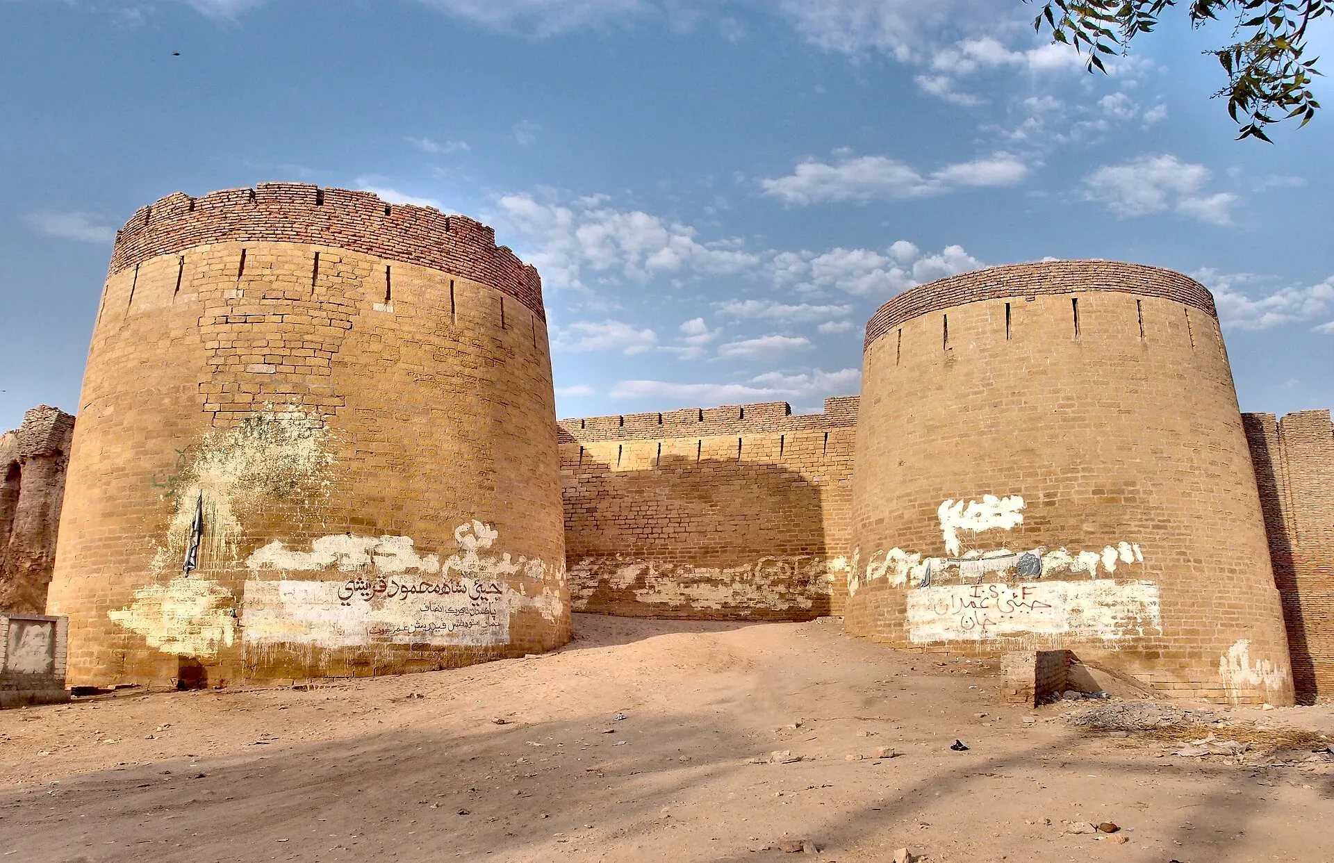
Photo: Saqib Qayyum, with thanks · CC BY-SA 3.0 · via Wikimedia Commons · temporary stand-in photo

Umerkot
Fort city in the Thar region of Sindh, where Emperor Akbar was born in 1542; district headquarters with 144,558 residents in 2023, Hindu temples and an old fort.
Overview
Umerkot (also Umarkot, formerly Amarkot) is a city in the Thar region of Sindh and the headquarters of Umerkot District. The name comes from Umer Soomro of the Umar Marvi folk tale. Sindhi is the main language of the city, and the traditional local language is Dhatki, a Rajasthani language closely related to Marwari. The 2023 census counted 144,558 people in the city (Pakistan Bureau of Statistics figures compiled by CityPopulation.de). In the district, Hindus were about 55.5% and Muslims about 44.3% in 2023, which gives the town a strong Hindu heritage alongside its Mughal one.
Plan your visit
- Nearest town
- Mirpur Khas
- Getting there
Road: Mirpur Khas about 78 km (about 57 minutes, optimistic OSRM estimate). Nearest airports at Hyderabad and Karachi region. More
Best months
Nov – Mar
- Umerkot
- Related places nearby: Umerkot Fort, Mithi, Mirpur Khas
History
Tradition says a branch of the Soomra dynasty founded the city. According to Wikipedia the Sodha Rajputs took it in 1226, were expelled in 1330 and regained power in 1439. Rana Parshad of the Sodhas gave refuge to the exiled Mughal emperor Humayun after Sher Shah Suri drove him out, and Akbar was born in Amarkot the following year, in 1542. The Mughals took the area in 1590, and in 1736 Noor Mohammad Kalhoro expelled the last Sodha chief.
Afterwards the city changed hands among Persians, Afghans, Kalhoras, Talpur Baloch and the Rathore Rajputs of Jodhpur, who annexed it in 1779. The British took the fort and city in 1843. In 1847 Rana Ratan Singh was hanged at the fort for killing a British-appointed governor during a tax protest. District headquarters moved to Mirpur Khas in 1906.
Umerkot Fort
The fort stands at the heart of the city. Wikipedia dates it to the 11th century and describes it as Rajput in style; it also records that in 1746 Noor Mohammad Kalhoro built a fort on the site. It is listed as a protected monument and described as open to the public, with a museum mentioned in the TDAP Pakistan Tourism Guide 2021. The fort is tied to the Umar Marvi story: Marvi, a young woman of Thar, refused to marry the ruler Umar and was held in the fort for years before her release. She is remembered locally for her courage.
Akbar's birthplace
Akbar was born at Umarkot on 15 October 1542, according to Wikipedia. The traditional site is open land near the fort, marked by a small pavilion.
Temples
Umarkot Shiv Mandir is a major Hindu pilgrimage site and one of the oldest temples in Sindh. Wikipedia also lists the Kali Mata and Krishna temples in old Amarkot. Folk tradition says the Hindu folk deities Pabuji and Ramdev were married in Umerkot. Visit as a guest, dress modestly and ask before photographing worshippers.
What to see and do
- Umerkot Fort and its museum.
- Akbar's birthplace.
- Shiv Mandir and the other old temples.
- The Umerkot Museum.
An honest outline for a day: the fort and museum in the morning, the birthplace pavilion next, then the temples in the afternoon. Opening hours and any entry fees are not confirmed; current fees will be added soon, so ask at the site.
Why you might pass through
Umerkot is the gateway to the Thar desert and to Mithi and Nagarparkar further east, and a stop on the way between Hyderabad and the desert.
Getting there
OSRM estimates Mirpur Khas at about 78 km and 57 minutes by road (optimistic estimate, checked 16 November 2026). The city is well connected to Karachi and Hyderabad.
Nearby
Mirpur Khas is the nearest city, Mithi lies deeper in Thar, and Nagarparkar has the Jain temples.
Safety
This town lies south of Nawabshah, so it is not inside the area where the UK FCDO advises against all but essential travel in Sindh (page updated 27 October 2026; checked 16 November 2026). For foreign visitors: the UK FCDO still notes a general risk of terrorism across Pakistan, so read its current page and local news before you go. The district lies near the Indian border; the FCDO page warns of a five-mile border zone, so read it before travelling east.
Highlights
- Fort city in the Thar region
- Birthplace of Emperor Akbar
- Shiv Mandir temple
- Gateway to Thar
Stay, eat and essentials in Umerkot
Places to stay
- Ghosia Guest HouseCall Ghosia Guest HouseMap of Ghosia Guest House in Google Maps
- Sunshine hostel 2Map of Sunshine hostel 2 in Google Maps
Places to eat
- Krishan Sweets and BakersCall Krishan Sweets and BakersMap of Krishan Sweets and Bakers in Google Maps
- Karachi FoodsCall Karachi FoodsMap of Karachi Foods in Google Maps
- Chandar Foods Sweets & BakersCall Chandar Foods Sweets & BakersMap of Chandar Foods Sweets & Bakers in Google Maps
- Dubai RestaurantCall Dubai RestaurantMap of Dubai Restaurant in Google Maps
- Cafe Latif HotelCall Cafe Latif HotelMap of Cafe Latif Hotel in Google Maps
Essential services fuel stations, mechanics, ATMs, pharmacies and hospitals and clinics
Fuel
- Super Shaheen Petroleum PSOCall Super Shaheen Petroleum PSOMap of Super Shaheen Petroleum PSO in Google Maps
- MASHALLAH CNG STATIONCall MASHALLAH CNG STATIONMap of MASHALLAH CNG STATION in Google Maps
- Hascol Petrol Pump - Awais karniCall Hascol Petrol Pump - Awais karniMap of Hascol Petrol Pump - Awais karni in Google Maps
- New Umerkot Petroleum ServiceCall New Umerkot Petroleum ServiceMap of New Umerkot Petroleum Service in Google Maps
- Asad Petroleum StationMap of Asad Petroleum Station in Google Maps
- AL-RASHID FILLING STATION- Total Petrol StationCall AL-RASHID FILLING STATION- Total Petrol StationMap of AL-RASHID FILLING STATION- Total Petrol Station in Google Maps
Mechanics and tyre shops
- Friends AutosMap of Friends Autos in Google Maps
- Bhatia Motor GarageCall Bhatia Motor GarageMap of Bhatia Motor Garage in Google Maps
- Abdul Haque Tyre AutosCall Abdul Haque Tyre AutosMap of Abdul Haque Tyre Autos in Google Maps
ATMs
- Meezan Bank - Umerkot BranchCall Meezan Bank - Umerkot BranchMap of Meezan Bank - Umerkot Branch in Google Maps
- Habib Metropoltan Bank Ltd Umerkot BranchCall Habib Metropoltan Bank Ltd Umerkot BranchMap of Habib Metropoltan Bank Ltd Umerkot Branch in Google Maps
- Soneri Bank Ltd Umerkot BranchCall Soneri Bank Ltd Umerkot BranchMap of Soneri Bank Ltd Umerkot Branch in Google Maps
Pharmacies
- Dr Gulab ChokCall Dr Gulab ChokMap of Dr Gulab Chok in Google Maps
- Marvi Medical & General StoreCall Marvi Medical & General StoreMap of Marvi Medical & General Store in Google Maps
- Paras Medical Store UmerkotCall Paras Medical Store UmerkotMap of Paras Medical Store Umerkot in Google Maps
- Mustafa PharmacyCall Mustafa PharmacyMap of Mustafa Pharmacy in Google Maps
- Sandeep Medical StoreCall Sandeep Medical StoreMap of Sandeep Medical Store in Google Maps
- MULLER & PHIPPS UMERKOT DEPOTCall MULLER & PHIPPS UMERKOT DEPOTMap of MULLER & PHIPPS UMERKOT DEPOT in Google Maps
Hospitals and clinics
- Dr Lal Chand Khatri HospitalCall Dr Lal Chand Khatri HospitalMap of Dr Lal Chand Khatri Hospital in Google Maps
- Advance Bone CareCall Advance Bone CareMap of Advance Bone Care in Google Maps
- Thar Medical CenterCall Thar Medical CenterMap of Thar Medical Center in Google Maps
- Dr haresh Assnani dental clinicCall Dr haresh Assnani dental clinicMap of Dr haresh Assnani dental clinic in Google Maps
- SINDH MEDICAL STOR.UMERKOTMap of SINDH MEDICAL STOR.UMERKOT in Google Maps
Listings come from Google Maps data and are unverified: phone numbers, opening months and prices may have changed. Report a problem · Own one of these? Claim it
Tips
- Check FCDO advice on border areas before travelling east.
- Visit between November and March; summers are very hot.
- Dress modestly and be respectful at temples.
- Carry identification; expect checkpoints.
Sources and last checked
Last checked Confidence medium7 sources4 still to check
- Last checked
- Method
- Desk research from published sources
- Confidence
- medium
- Checked by
- trek.pk research team
Researched from published sources; not yet checked on the ground by our team. Spot something out of date? Report a mistake.
Sources
- Umerkot · Wikipedia · checked
- Pakistan: districts and cities, 2023 census (compiled from the Pakistan Bureau of Statistics) · CityPopulation.de · checked
- Pakistan Tourism Guide 2021 · TDAP · checked
- OSRM public routing demo (driving, optimistic) · Project OSRM · checked
- Pakistan travel advice · UK Foreign, Commonwealth & Development Office (FCDO) · checked
- Pakistan travel advice: warnings and insurance (updated 27 October 2026) · UK Foreign, Commonwealth & Development Office · checked
- Umerkot Fort · Wikipedia · checked
Still to be checked on the ground (4)
- Fort and temple visiting hours
- Which Thar road routes are open
- Date of the fort (Wikipedia gives the 11th century and a 1746 fort on the site)
- Hours of the museum and temples
Nearby and related

Umerkot Fort
A rectangular brick fort in the Thar desert town of Umerkot, linked to the birth of the Mughal emperor Akbar in 1542. Listed on Pakistan's UNESCO tentative list (2026, per Wikipedia).

Mithi
The district headquarters of Tharparkar in Sindh, a Hindu-majority town in the Thar Desert and the practical base for Islamkot, Nagarparkar and the green desert after the monsoon.

Mirpur Khas
Sindh's City of Mangoes, founded by the Talpurs in 1806, with the Chitorri tombs and Buddhist-era remains, about 70 km east of Hyderabad.

Nagarparkar Jain Temples
Ruined Jain temples and a marble mosque around Nagarparkar in the Karoonjhar hills of Tharparkar, from about the 12th to 15th centuries. The Nagarparkar Cultural Landscape is on Pakistan's UNESCO tentative list (2016).

Sindh
Pakistan's south-east: Karachi's beaches and markets, the Indus Valley city of Moenjodaro, Thatta's Makli tombs, Sufi shrines, the Thar desert and the Indus delta.