

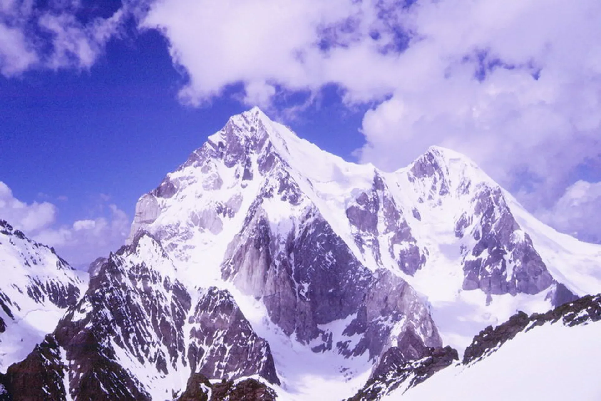
Photo: Nkroup, with thanks · CC BY-SA 3.0 · via Wikimedia Commons · temporary stand-in photo

Phargam An
- Duration
- 4 days
- Distance
- 52.5 km
- Grade
- Strenuous
- Max altitude
- 4,975 m
- Season
- Jul – Sep
A demanding four-day trek over a 4,975 m pass from Golen Gol to Laspur, passing the south and east side of Buni Zom. Needs a guide and good route-finding.
Overview
Phargam An (4,975 m) links Golen Gol with the Laspur valley, on the western side of the Shandur Pass. It was a regular summer route before the Chitral to Gilgit road was built. Today it is rarely walked. The route passes between Buni Zom and Ghuchhar Sar, and gives views of both. It covers about 52 km in four days, from Istor to Harchin.
This is the hardest trek in this group. The pass day needs several hours of Class 2 scrambling over huge granite talus, on an obscure route where you must find your own way.
Who it suits
It suits experienced, fit trekkers who are comfortable above 4,000 m and with off-trail navigation. It is not a technical climb, but you sleep two nights at high camps above the tree line, and the pass day is 8 to 10 hours. It is graded strenuous here. Some operators call it moderate, others consider it more serious because of snow and loose ground. A guide or knowledgeable porter is essential.
When to go
July to mid-September. Expect a fair amount of snow on the pass until mid-August, and a small cornice on the north side. In the afternoon, the glacial stream near the upper Phargam Gol can only be crossed in the morning.
The route
The road now reaches higher than Istor, as far as Chhatar Ghuni and Dukadaki, so special-hire jeeps can shorten the walk by one to 1.5 days. From Istor (2,700 m) you follow Golen Gol past Romen to the plain at Chhatar Ghuni (3,000 m), called Jungal locally. Day two climbs through the Gujar huts of Dangari Kuru and Dukadaki to Chakoli Bokht (3,600 m), then crosses talus to the stone shelters at Jeshtanan camp (4,050 m) beneath the Golen Glacier.
Day three is the pass. Climb the lateral moraine on the north bank of the glacier stream, then turn left up an unlikely-looking talus slope. Ascend granite blocks to a grassy, flowery bench, and then continue up talus, following what remains of an old trail built for a Mehtar of Chitral. The pass, with a memorial plaque to an Austrian climber, is 4.5 to 6 hours from camp. Descend across talus to meadows and onwards to Phargam High Camp (3,900 m) in the upper Phargam Gol. On day four you follow the river down past hanging glaciers to Phargam village and then the Rahman road to Harchin (3,000 m).
The peaks above the route
The Buni Zom group lies in the Hindu Raj range, about 50 km north-east of Chitral town and about 50 km east of Tirich Mir. The main peak, Buni Zom, is 6,542 m, and the group has several other summits above 6,000 m, including Awi Zom (6,484 m). Ghochhar Sar (6,249 m) is a neighbour. The first ascent of Buni Zom was made in 1957 by the New Zealanders W. K. A. Berry and C. H. Tyndale-Biscoe, by the north ridge. The pass day looks across this group, and the upper Phargam Gol runs beneath its hanging glaciers.
Preparing for the pass day
- Fitness and time. Day 3 is 8 to 10 hours, with about 925 m of climbing and 1,075 m of descent. Most of the climb is on talus (loose rock) and granite blocks, so strong ankles and a steady head for scrambling matter more than speed.
- Acclimatisation. Two nights are spent at about 3,900 to 4,050 m. Spend time at Istor or Chhatar Ghuni first.
- Navigation. The route is obscure, and rockfall and retreating glaciers have changed it, so a guide or porter who has crossed recently is more use than a map.
- Start time. The stream below Buni Zom can only be crossed in the morning, so start early on Day 3 and again on Day 4.
- Equipment. Carry a stove and fuel, because Jeshtanan camp is only three small stone shelters and Chakoli Bokht is the last summer grazing. A helmet is sensible in the gully. Bring crampons and an ice axe if snow lies on the pass.
Culture and people
Golen Gol people graze sheep and goats at Chakoli Bokht. Other summer settlements belong to Gujars who do not know this pass, and Madaglasht men do not know it either. Locals say that small spirits called jeshtan are seen near the Jeshtanan camp. Buni Zom (6,542 m) was first climbed in 1957 by a New Zealand expedition. Climbers base themselves at Phargam High Camp.
Practical information
Chitral to Istor by jeep takes about two hours; jeeps leave in the late morning from the Chew Bridge stand north of town. Harchin to Mastuj is a 20 km jeep ride, and Mastuj to Chitral jeeps are easy to find but you may need to stay a night in Mastuj. You can also pre-arrange a hire to meet you at Phargam village. Maps: US AMS 1:250,000 sheets Churrai and Mastuj, and Survey of India 1:63,360 sheets 43 A/1, 42 D/4 and 42 D/8.
In July 2026 a Pakistani team supported by the KP Culture and Tourism Authority crossed Phargam An and reported glaciers, steep snow, loose rock and avalanche-prone ground, with rockfall and glacier retreat having changed the route since earlier crossings. Expect the old guidebook description to be out of date in places.
Highlights
- High pass between Buni Zom and Ghuchhar Sar
- Old Mehtar's horse trail remnants on the pass
- Hanging glaciers and waterfalls in upper Phargam Gol
- Ibex habitat and wildflower meadows
Day by day
| Day | Camp | Altitude |
|---|---|---|
| 1 | Chhatar Ghuni (Jungal) | 3,000 m |
| 2 | Jeshtanan camp | 4,050 m |
| 3 | Phargam High Camp | 3,900 m |
| 4 | Harchin | 3,000 m |
| Day | Route | Hours | Distance | Ascent / descent | Camp and altitude |
|---|---|---|---|---|---|
| Day 1 | Istor to Chhatar Ghuni | 5.5 h | 7.5 km | +300 m | Chhatar Ghuni (Jungal), 3,000 m |
Day 1 notesIstor (2,700 m) is Golen Gol's highest village, with a spring and shaded camp across the river. The trail narrows and runs 5 km to Romen, a level place with huts and springs. Another 2.5 km leads to a broad grassy plain with streams, a few huts and fields. Maps call it Chhatar Ghuni, locals say Jungal. The Lohigal Gol branches south here. | |||||
| Day 2 | Chhatar Ghuni to Jeshtanan camp | 5 h | 16 km | +1,050 m | Jeshtanan camp, 4,050 m |
Day 2 notesPass the Gujar huts of Dangari Kuru (3,150 m) and Dukadaki. About 5 km further, in stony barren ground, are the huts of Chakoli Bokht (3,600 m), the last summer grazing. Cross talus fields and two side streams towards the cliffs under the Golen Glacier. Three small stone shelters at the cliff foot form Jeshtanan camp, with clear water and some wind. | |||||
| Day 3 | Jeshtanan camp over Phargam An to Phargam High Camp | 8–10 h | 9 km | +925 m / −1,075 m | Phargam High Camp, 3,900 m |
Day 3 notesClimb the lateral moraine, turn left up a talus slope and scramble huge granite blocks to a grassy bench. Follow remains of an old horse trail to the pass (4,975 m), 4.5 to 6 hours from camp. Snow and a small cornice may be present. Descend across talus to flower meadows and then to upper Phargam Gol. Camp before the big waterfall stream, which can only be crossed in the morning. | |||||
| Day 4 | Phargam High Camp to Harchin | 6–8 h | 20 km | −900 m | Harchin, 3,000 m |
Day 4 notesFord the milky morning river, cross another glacial stream and follow the trail down the valley beneath hanging glaciers. Above Phargam village there is a spring and the start of an unsealed road to Rahman. Walk the road to Rahman on the west bank of the Laspur River, then cross the bridge to Harchin on the Chitral to Gilgit road. | |||||
Getting there
Chitral to Istor by jeep takes about two hours. Jeeps leave in the late morning from the Chew Bridge stand north of town. The road continues past Istor to Chhatar Ghuni and Dukadaki, so you can hire a jeep to shorten the walk by one to 1.5 days. At the end, go from Harchin to Mastuj by jeep (20 km) and on to Chitral.
Permits and rules
- Permit needed
- Usually not, Open zone
- Fee
- Current fees will be added soon
- Last checked
- 16 November 2026
The old guide listed this as an open zone with no trek permit. Foreign visitors need a No Objection Certificate (NOC) for Chitral district. A Senate committee briefing reported on 6 May 2026 that the requirement is still in force, and KP Tourism launched an online NOC system in July 2025 that registered tour operators use. Rules have been relaxed and reinstated before, so confirm the current position with a Chitral tour operator, KP Tourism or the Deputy Commissioner's office in Chitral before you travel (checked 16 November 2026). Pakistani citizens do not need a trek permit, but carry your CNIC.
How trekking permits, NOCs and registration work: Visa and permits.
Season
Best: Jul – Sep
Water and camps
Water is clear at Jeshtanan camp and on the lower slopes of the pass descent. There is none on the upper talus. At Phargam High Camp (3,900 m) there are grassy sites among clear streams. Day 1 camps are green and sheltered; Istor and Chhatar Ghuni have springs. Two nights are above the tree line, so carry a stove and fuel.
Gear and safety
You spend two nights at about 3,900 to 4,050 m and cross 4,975 m. Allow acclimatisation days at Chhatar Ghuni or Istor. The pass route is obscure, so use a guide. Rockfall and loose talus are common, and a helmet is sensible in the gully near Gulabmali. Cross the waterfall stream below Buni Zom only in the morning. The pass west of Dangari Kuru (about 5,070 m) is fully glaciated and not for trekkers. A July 2026 crossing reported that rockfall and retreating glaciers have changed the route, so do not rely on the old description. Rescue is distant: the nearest roadhead and medical care are at Istor, Harchin and Mastuj.
Ask the district administration or local police about current conditions before you go. For foreign visitors: the UK FCDO advises against all travel on the N-45 from north of the Mardan ring road to the edge of Chitral city, including the Kalash valleys (advice updated 27 October 2026, checked 16 November 2026). Most road routes to Chitral use the N-45. Read the live advice before you plan.
Variations
Phargam An can follow the Lohigal An trek from Shishi Gol, but detour down Golen Gol to Istor to find a guide. Climbers use Phargam High Camp as base for Buni Zom, with Khora Bort Zom (5,850 m) and Panorama peak (5,690 m) nearby. Roghili Gol (see that trek) is an easier trip from the same valley.
Tips
- Hire a guide or porter who has crossed the pass before.
- Start the pass day early. Streams are higher in the afternoon.
- Do not try the pass at the head of Sachiokuh Gol. It is fully glaciated.
- If you do the Lohigal An trek first, detour to Istor to find a guide.
Stay and eat in Mastuj
Mastuj is the nearest town to the trek: somewhere to sleep and stock up before and after.
Places to stay
- Hot Spring Guest HouseCall Hot Spring Guest HouseMap of Hot Spring Guest House in Google Maps
- Noor Mahal GuesthouseCall Noor Mahal GuesthouseMap of Noor Mahal Guesthouse in Google Maps
- Mastuj Hindukash HeightsMap of Mastuj Hindukash Heights in Google Maps
- PTDC Motel -MastujCall PTDC Motel -MastujMap of PTDC Motel -Mastuj in Google Maps
- Al Salah Hotel & Restaurant MastujCall Al Salah Hotel & Restaurant MastujMap of Al Salah Hotel & Restaurant Mastuj in Google Maps
Listings come from Google Maps data and are unverified: phone numbers, opening months and prices may have changed. Report a problem · Own one of these? Claim it
Photos we still need: the pass, Jeshtanan camp and the upper Phargam Gol (no open-licence photo found). Send us yours
Health and emergency
Mobile signal is patchy on most treks, so tell someone your plan before you go. Emergency numbers
Sources and last checked
Last checked Confidence medium8 sources7 still to check
- Last checked
- Method
- Desk research from published sources
- Confidence
- medium
- Checked by
- trek.pk research team
Researched from published sources; not yet checked on the ground by our team. Spot something out of date? Report a mistake.
Sources
- Trekking in the Karakoram and Hindukush (Lonely Planet, c. 2002), Chitral chapter · Lonely Planet · checked
- Lesser-known treks of Chitral and the Hindu Raj edge (research notes) · trek.pk research, 2026-11-15 · checked
- Phargam An trek · Apricot Tours · checked
- Buni Zom · Wikipedia · checked
- Golen valley glacial flood damage · Dawn · checked
- Senate panel flags hurdles to Chitral tourism (6 May 2026) · The Express Tribune · checked
- KP launches online NOC system for foreign tourists (July 2025) · Daily Times / APP · checked
- Pakistani expedition reopens historic Hindu Kush pass after 27 years (22 July 2026) · ProPakistani · checked
Still to be checked on the ground (7)
- Pass height: 4,975 m (Lonely Planet, Apricot); 4,700 m on another operator itinerary; a 5,056 m pass on another; a July 2026 press report gives 5,100 m for the summit reached, not the pass. No survey figure
- Whether the road still reaches Chhatar Ghuni and Dukadaki after the Golen floods
- Day 3 timing (8 to 10 hours) and exact route on the talus
- State of the glacier and snow cornice by season (a July 2026 crossing found glaciers retreating and the route changed; seasonal detail still open)
- Guide availability in Istor and Phargam
- Current NOC conditions for foreigners (Chitral NOC still required per the 6 May 2026 Senate briefing; scope not confirmed officially)
- Whether crampons and an ice axe are needed on the pass in August and September (old guide mentions snow and a small cornice until mid-August; no recent source on equipment)
Nearby and related
Roghili Gol

Other treks in Chitral

Ansoo Lake Trail

Buni Zom
Buni Zom (6,542 m) is the highest peak of the Buni Zom massif in the Hindu Raj, in Upper Chitral. It was first climbed in 1957 by two New Zealanders.
Phargam An
A demanding pass of 4,975 m between Golen Gol and the Laspur valley in Chitral, passing Buni Zom. Four days from Istor to Harchin. Obscure route, guide essential.
Kuru An
A pass of about 4,700 m used by ibex hunters between the Baj Gaz Gol and the Pakora Gol in the Ishkoman valley. Demanding three or four day near-loop.

Shandur Pass
A high grassy pass of about 3,720 m between Ghizer in Gilgit-Baltistan and Upper Chitral. Home to the Shandur polo ground and a summer festival, reached by a rough road.