

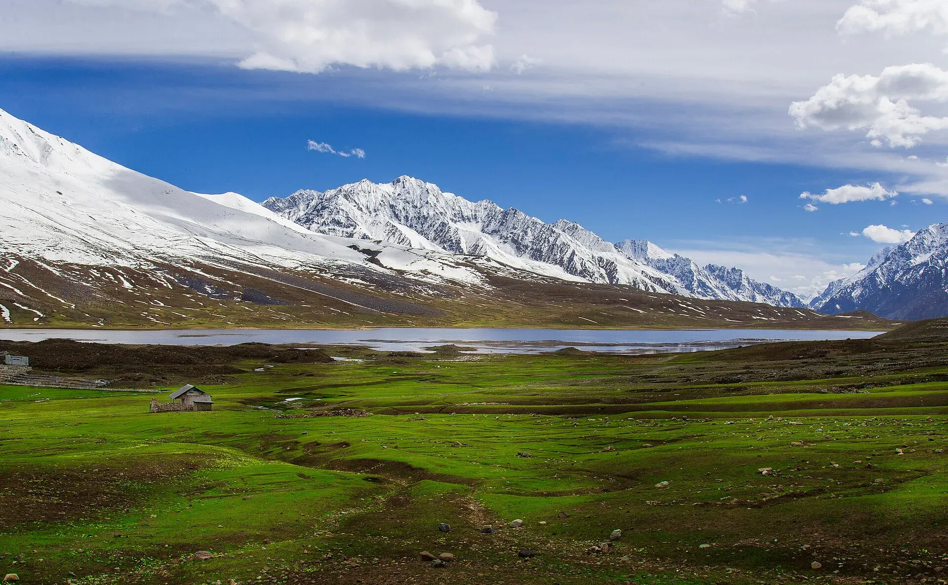
Photo: Mudassir Ahmed, with thanks · CC BY-SA 4.0 · via Wikimedia Commons · temporary stand-in photo

Shandur Pass
A high grassy pass of about 3,720 m between Ghizer in Gilgit-Baltistan and Upper Chitral. Home to the Shandur polo ground and a summer festival, reached by a rough road.
Overview
Shandur Pass is a wide, flat plateau rather than a sharp saddle. It lies on the boundary between Ghizer in Gilgit-Baltistan and Upper Chitral in Khyber Pakhtunkhwa, and carries the road between Gilgit and Chitral. Wikipedia gives its height as about 3,720 m (12,205 ft). The 2021 TDAP guide gives 3,734 m, Dawn quoted about 12,200 feet in 2026, and Wikipedia's polo festival article puts the pass at 3,800 m and the polo ground at 3,700 m. The figures differ by up to about 100 m, so treat them as "about 3,700 m". Wikipedia puts the pass 212 km from Gilgit, which fits the district sheet figure of 146 km from Gahkuch used on our Ghizer page.
It is best known for the Shandur polo ground, which the tourism department describes as the highest in the world, and for a lake beside it. It is a road pass; trekkers come for the Thui An, Shah Jinali and other crossings nearby.
Plan your visit
- Nearest town
- Laspur (Chitral side) or Phander (Ghizer side)
- Getting there
From Gilgit, drive west up the Ghizer valley through Gupis and Phander to Shandur; the pass is about 212 km from Gilgit by Wikipedia's figure. On the Chitral side, the road runs from Laspur and Mastuj. More
Best months
Jun – Sep
- Shandur Pass
- Related places nearby: Chitral Valley, Chitral, Phander Lake, Hundrap-Shandur National Park, Mastuj, Booni, Phander
The polo ground and festival
The polo ground sits on the plateau next to the lake. Wikipedia gives its size as about 200 m by 56 m, smaller than a regular polo field of about 270 m by 150 m. Low stone walls about 60 cm high run along both sides in place of boards. Each team has six players, with two to four reserves.
The Shandur Polo Festival is a free-style tournament between teams from Chitral and Gilgit-Baltistan. Free-style means few rules: Wikipedia says players rarely wear helmets and mallets often have no grips or straps. A match usually lasts one hour, in two halves with a ten-minute interval, when local people perform music and dance. Preliminary matches in Chitral and Gilgit choose the teams, and the final is on the last day. Around the ground a tent village is set up, with folk music and dancing. Wikipedia says the festival is organised and financed by the Khyber Pakhtunkhwa and Gilgit-Baltistan governments with help from the Frontier Corps (North).
In 2026 the Khyber Pakhtunkhwa government announced the festival for 11 to 13 June (Dawn, 24 April 2026), with paragliding and cultural nights also listed. Wikipedia gives 7 to 9 July as the usual dates. Dates move from year to year, so confirm them before planning.
Shandur Lake and the plateau
Shandur Lake, also called Hundrup Lake, lies between the pass and the polo ground, inside Shandur-Hundrup National Park. Wikipedia describes it as a glacier-fed alpine lake of about 1.4 sq km, with the Gilgit River as its outflow. Outside the festival the plateau is quiet: you can walk around the lake and watch herders with their animals.
Wikipedia also lists a Shandur Ice Sports Challenge on the frozen lake from 24 to 28 December, with ice hockey and speed skating between Chitral and Gilgit-Baltistan teams. That sits oddly with a road that is normally snowed in, so ask locally before planning any winter visit.
Road and routes
From Gilgit, the road runs west up the Ghizer valley through Gupis and Phander to the pass. The Ghizer side is mostly paved as far as Phander, then narrower and part paved. On the Chitral side the road drops through Laspur and Mastuj. The stretch from Shandur to Mastuj is rough dirt and rock, best done with a 4x4 or a motorbike. A road upgrade has been planned, but its status is not confirmed.
Trekkers use the passes either side of the plateau. See the Thui An and Shah Jinali An pages. Bikers can read about the Gilgit to Chitral summer route.
When to visit
The pass is snowed in through winter. Treat June to September as the working season, and expect snow and mud at either end of it. Reports for the Gilgit to Chitral crossing treat it as a summer-only road. Check locally before setting out.
Where to stay and eat
There are guest houses in Phander and Gupis on the Ghizer side, and in Mastuj and Laspur on the Chitral side. At festival time a tent village sets up on the pass, and food stalls open. Otherwise bring your own supplies and camping gear.
Good to know
- Fees. Entry or camping charges may apply at festival time. Current fees will be added soon.
- Ask the district administration or local police about current conditions before you go. Travel advice. For foreign visitors: the UK FCDO (updated 27 October 2026) advises against all travel on the N-45 up to the edge of Chitral city, including the Kalash valleys. It does not advise against Gilgit-Baltistan generally. The Chitral side of Shandur is a separate area from the N-45 stretch named, but check the live page and local conditions before travelling.
- Altitude. About 3,700 m is high enough for headaches. Sleep lower on the first night if you can.
Highlights
- The highest polo ground in the world, at about 3,720 m
- Shandur Polo Festival, held in summer
- Link between Ghizer and Chitral
- Open grassland and Shandur Lake
Getting there
From Gilgit, drive west up the Ghizer valley through Gupis and Phander to Shandur; the pass is about 212 km from Gilgit by Wikipedia's figure. On the Chitral side, the road runs from Laspur and Mastuj. Allow a full day for either side, and more on the rough Chitral descent.
Tips
- Confirm festival dates each spring with KP and GB tourism
- Allow extra days: the Chitral-side road is slow
- Carry warm clothes and a tent: nights are cold
- Check bridge and road conditions in Mastuj before you set out
Sources and last checked
Last checked Confidence medium6 sources5 still to check
- Last checked
- Method
- Desk research from published sources
- Confidence
- medium
- Checked by
- trek.pk research team
Researched from published sources; not yet checked on the ground by our team. Spot something out of date? Report a mistake.
Sources
- Shandur Pass (Wikipedia) · Wikipedia · checked
- Shandur polo festival to begin on June 11 (24 April 2026) · Dawn · checked
- Pakistan Tourism Guide 2021 · TDAP Pakistan · checked
- Pakistan travel advice (updated 27 October 2026) · UK FCDO · checked
- Shandur Polo Festival · Wikipedia · checked
- Shandur Lake · Wikipedia · checked
Still to be checked on the ground (5)
- Current road condition and any upgrade work (no source)
- Festival dates each year and any entry charges (2026 dates 11 to 13 June confirmed by Dawn 24 Apr 2026; no charges published)
- Festival dates: Wikipedia gives 7 to 9 July; Dawn gave 11 to 13 June for 2026
- Winter ice-sports event on the lake (Wikipedia, 24 to 28 December) and whether the road is open then
- Heights of pass and polo ground (3,700 to 3,800 m depending on source)
Nearby and related

Thui An

Shah Jinali An

Phargam An

Kachakani An

Chumarkhan An

Ghizer Valley
The long upper Gilgit River valley running west from Gilgit to Shandur, with Punial orchards, Gahkuch, Gupis, Khalti and Phander lakes, trout fishing and side valleys to Yasin and Ishkoman.

Chitral Valley
The long Chitral River valley at the foot of the Hindu Kush, with Chitral town's fort and Shahi Mosque, the Lowari Tunnel route, Tirich Mir views and side valleys leading to Kalash and Shandur.

Laspur Valley
A high side valley in Upper Chitral on the road to Shandur Pass, with Mastuj, Sor Laspur and lakes, and trek links to Swat and Ghizer. Information is limited, so confirm road and rules locally.

Gilgit
Gateway to Gilgit-Baltistan on the Karakoram Highway: a busy mountain town with the Kargah Buddha and the base for Hunza, Naltar and Skardu.

Chitral
The main town of Lower Chitral District, at about 1,500 m on the Chitral River, with a historic fort, a royal mosque and views of Tirich Mir. The base for the Kalash valleys.

Phander Lake
A small, deep lake in Phander village, Gupis-Yasin district, in the far west of Gilgit-Baltistan. It is fed by the Ghizer River and sits on the road between Gilgit and Shandur.
Hundrap-Shandur National Park
A high-altitude park in Ghizer, Gilgit-Baltistan, declared in 1993 according to the GB Forest, Wildlife and Environment Department. About 51,800 hectares around Shandur Pass, with ibex, snow leopard and brown bear.
Mastuj
The main settlement of Mastuj valley in Upper Chitral, at about 2,359 m. It has an old fort ruin, big mountain views, and is the last major stop on the road to Shandur Pass and Gilgit.

Booni
Headquarters of Upper Chitral District at about 2,085 m, near the foothills of Buni Zom and the Qaqlasht meadows. It is a base for local walks and a stop on the road to Mastuj and Shandur.

Phander
A village and valley in Ghizer, Gilgit-Baltistan, on the Gilgit to Shandur road. It is known for its lake, trout streams and quiet fields, and is a common overnight stop before Shandur Pass.

Gupis
A small town on the road between Gilgit and Shandur, in Gupis-Yasin District of Gilgit-Baltistan. It is a practical overnight stop and the gateway to Phander and the Yasin valley.
Gilgit-Shandur-Chitral Summer Biker Route
A 3-4 day summer ride from Gilgit over Shandur Pass (about 3,720 m) to Chitral through the Ghizer and Yarkhun valleys. Rough track on the Chitral side; summer only.

Chitral and Kalash
A 6-7 day road trip from Islamabad to Chitral through Dir and the Lowari Tunnel, with the Kalash valleys of Bumburet, Rumbur and Birir, Chitral Fort and Tirich Mir views.