

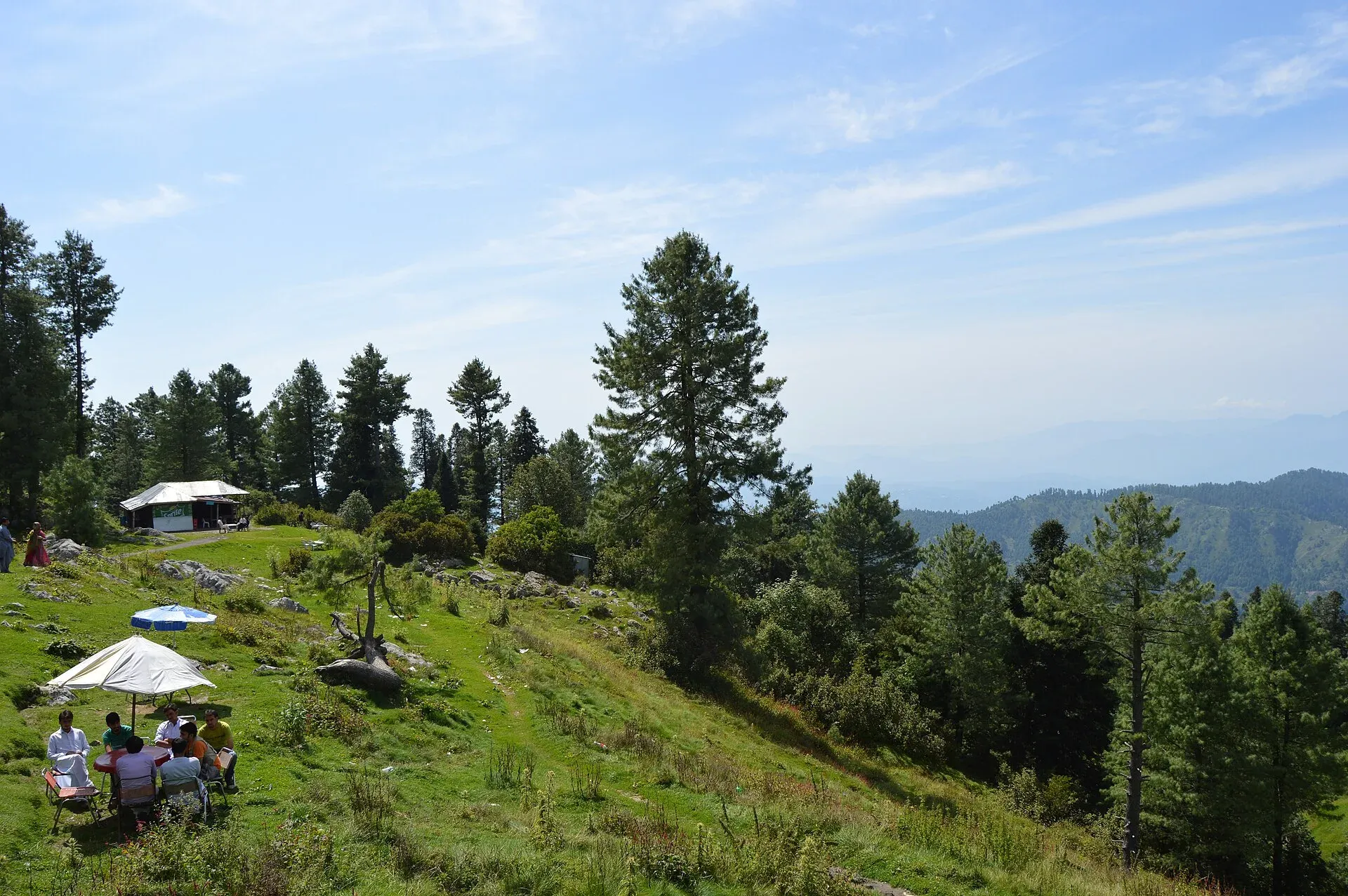
Photo: Scifikid, with thanks · CC BY-SA 4.0 · via Wikimedia Commons · temporary stand-in photo

Thandiani Trail
- Duration
- 1 day
- Grade
- Strenuous
- Max altitude
- 2,750 m
- Season
- May – Oct
A long day on foot from Abbottabad up to the pine ridge at Thandiani (about 2,750 m). Distance and time are poorly documented; most visitors drive. Hike only with local advice.
Overview
Thandiani is a hill station in the Galyat, about 37.5 km north-east of Abbottabad by Wikipedia's figure (Nathiagali.com gives 31 km, and other guides 31 to 37 km; OSRM measures 27 km by road, about 45 minutes of driving). Wikipedia gives its height as about 2,750 m, and TDAP gives 2,500 m. The name is said to mean "very cold". Most visitors drive up. A walking route climbs from the Abbottabad foothills.
The surrounding mountains are more heavily forested than most hill stations in the area. Wildlife includes leopards, monkeys, several pheasant species, flying squirrels and pine martens.
Who it suits
Fit, experienced walkers who like a long, steep day. The route is documented mainly by GPS tracks and a few blogs, so it suits people who can navigate and who go with someone local. It is not a casual stroll.
When to go
May to October is the safest season. Snow is most likely from December to February, which suits winter views but not walking. In January 2026 the Thandiani–Ukhrila–Andarsiri road stayed closed for 14 days after heavy snow, according to a report on the day it reopened. Monsoon storms make the forest slippery and can bring landslides on the road.
Getting to the start
Abbottabad is about 2 to 2.5 hours from Islamabad by road (OSRM: about 105 km, 1 hour 20 minutes of driving). Two starting points appear in the sources.
- Mera Rehmat Khan. One listing says to take a local bus or shared taxi from the Abbottabad bus stand, about 25 to 30 minutes, then follow an uphill path of about 4 km. It gives 1 to 1.5 hours and says the path steepens near the top.
- Pajo mosque, via Dagri Naka. A GPS record starts here in the Abbottabad foothills. It is far longer than the other listing, and the two have not been reconciled.
The route
The GPS record climbs through villages and forest by way of Dagri Naka to the Thandiani ridge. The climb is over 1,000 m. There is no reliable distance or time, so treat it as a long day and start at dawn. Many forest tracks cross, and mobile signal can fail among the trees.
Thandiani itself stands on a pine-covered ridge. From the top, Nathiagali.com lists views of the Kashmir ranges to the east, Kohistan and Kaghan to the north, the Swat ranges to the north-west and the Abbottabad plains to the south-west, with Tarbela Lake far off.
The ridge to Nathia Gali
A longer route runs from Thandiani along the ridge to Nathia Gali. A 2009 trekking blog, with comments from 2012 and 2013, describes it in four stages.
- Thandiani to Birangali (Beran Gali). Mostly downhill, 3 to 4 hours. The village (about 1,900 m) has a forest rest house, and a stream runs about five minutes below it.
- Birangali to Dagri. The hardest stage, mostly uphill, 5 to 6 hours, through old oak forest. The Dagri rest house stands at about 2,720 m. The blog says it was damaged in the 2005 earthquake and later reported locked. Readers found little water after the first 3 to 4 km, so carry extra.
- Dagri to Miranjani Top. A climb of 10 to 11 km to about 2,980 m, the highest point of the Galyat. On a clear day it gives views across the Kashmir ranges.
- Miranjani Top to Nathia Gali. About 8 km, downhill to about 2,520 m, where public transport is easier to find.
The blog's distances add up to about 45 km, while two readers measured 38.6 and about 40 km. Other guides give Birangali to Dagri as about 13 km, against 15 km here, so treat all distances as approximate. The blog recommends three days with nights at Birangali and Dagri. It says overnight stays in the rest houses needed written permission from the District Forest Office; confirm the current position. The Dagri pine forest is isolated and has leopards.
Culture and people
The site was first leased to the Battye family, who were missionaries, and later passed to the Anglican church. In the British period it had a sanatorium, private European houses and a small seasonal church, St Francis Xavier "in the Wilderness". These were used in summer only. Thandiani was damaged in the 2005 earthquake. Local communities live on the lower slopes. Respect homes and farmland on the way.
Practical information
- Nathiagali.com describes Thandiani as undeveloped, with a few huts and tea stalls. It lists pod accommodation run by the Khyber Pakhtunkhwa tourism department. Food stops on the walk are not reliable.
- The road up is metalled and zigzags. Parking at the top is limited.
- Plan the return by road: taxis run from Thandiani to Abbottabad.
- Carry water, food and a torch.
Highlights
- Pine forest hill station at about 2,750 m
- Long, steep day climb from Abbottabad
- Links to the Galyat ridge towards Nathia Gali
- Wildlife includes leopards and pheasants
Day by day
- StartAbbottabad foothills (Pajo mosque, via Dagri Naka)
- Day 1Thandiani
| Day | Route | Hours | Distance | Ascent / descent | Camp and altitude |
|---|---|---|---|---|---|
| Day 1 | Abbottabad foothills to Thandiani | long day, not reliably documented | not given | not given | not given |
Day 1 notesStart at the foothills near Pajo mosque (or at Mera Rehmat Khan, the start in a second listing) and climb through villages and forest by way of Dagri Naka. The slope is steady and steep, and the climb is over 1,000 m. Forest tracks cross each other, so keep a GPS track or local guide. Thandiani sits on a pine-covered ridge, where you can eat and rest before taking a taxi back. | |||||
Getting there
Abbottabad is about 2 to 2.5 hours from Islamabad by road. The walk begins in the foothills near Abbottabad (Pajo mosque and Dagri Naka in GPS records; Mera Rehmat Khan, reached by local bus in about 25 to 30 minutes, in another listing). Taxis and local vans also drive the Thandiani road, about 27 km by OSRM and 31 to 37.5 km in other sources. The road is metalled but zigzags steeply, and parking at the top is limited.
Permits and rules
- Permit needed
- Usually not, Open zone
- Fee
- Current fees will be added soon
- Last checked
- 16 November 2026
No permit is known for the walk, but we have not confirmed this. Check locally. Current fees, if any, will be added soon.
How trekking permits, NOCs and registration work: Visa and permits.
Season
Best: May – Oct
Water and camps
Carry all the water you need. Camping on the ridge is not documented; stay in Thandiani guesthouses or Abbottabad. On the ridge route to Nathia Gali, a stream runs below the Birangali rest house, but a 2013 reader found little water on the way to Dagri.
Gear and safety
Wildlife
Leopards live in the forests. Hike in daylight and in groups.
Getting lost
Many forest tracks cross each other. Use a GPS track or a local guide.
Weather
Fog and storms come quickly; the road can be cut by snow or landslides.
Fitness
Strenuous: plan a full day and carry food, water and a torch.
Variations
The ridge traverse from Thandiani to Nathia Gali (via Birangali, Dagri and Miranjani Top) is multi-day and strenuous: about three days, with nights at Birangali and Dagri, per a 2009 blog. See also the Miranjani Top Trail.
Tips
- Start at first light
- Take more water than you think you need
- Go with a local guide or a group
- Arrange a taxi back from Thandiani
Stay and eat in Abbottabad
Abbottabad is the nearest town to the trek: somewhere to sleep and stock up before and after.
Places to stay
- Hotel One AbbottabadCall Hotel One AbbottabadMap of Hotel One Abbottabad in Google Maps
- Hotel SarbanCall Hotel SarbanMap of Hotel Sarban in Google Maps
- The Point by Roomy, ThandianiCall The Point by Roomy, ThandianiMap of The Point by Roomy, Thandiani in Google Maps
- Triple One Hotel SuitesCall Triple One Hotel SuitesMap of Triple One Hotel Suites in Google Maps
- Tulip Guest HouseCall Tulip Guest HouseMap of Tulip Guest House in Google Maps
- Siran Valley Hotel (Guest house)Call Siran Valley Hotel (Guest house)Map of Siran Valley Hotel (Guest house) in Google Maps
Places to eat
- KFC | AbbottabadCall KFC | AbbottabadMap of KFC | Abbottabad in Google Maps
- Food PlanetCall Food PlanetMap of Food Planet in Google Maps
- Flame On Jadoon PlazaCall Flame On Jadoon PlazaMap of Flame On Jadoon Plaza in Google Maps
- MNAK Restaurant AbbottabadCall MNAK Restaurant AbbottabadMap of MNAK Restaurant Abbottabad in Google Maps
- CrunchiousCall CrunchiousMap of Crunchious in Google Maps
- deMinister Cafe, AbbottabadCall deMinister Cafe, AbbottabadMap of deMinister Cafe, Abbottabad in Google Maps
Essential services fuel stations, mechanics, ATMs, banks, pharmacies and hospitals and clinics
Fuel
- ShellCall ShellMap of Shell in Google Maps
- PSO ROYAL STAR FILLING STATIONCall PSO ROYAL STAR FILLING STATIONMap of PSO ROYAL STAR FILLING STATION in Google Maps
- Chanar CNG Station QalandarabadMap of Chanar CNG Station Qalandarabad in Google Maps
- Goharabad PSO PumpMap of Goharabad PSO Pump in Google Maps
- Valley CNG stationCall Valley CNG stationMap of Valley CNG station in Google Maps
- Yasrab CNGCall Yasrab CNGMap of Yasrab CNG in Google Maps
Mechanics and tyre shops
- Al Azizia Auto workshopCall Al Azizia Auto workshopMap of Al Azizia Auto workshop in Google Maps
- Khan Honda Center Qalandar Abad خان ھنڈا سنٹر قلندرآبادCall Khan Honda Center Qalandar Abad خان ھنڈا سنٹر قلندرآبادMap of Khan Honda Center Qalandar Abad خان ھنڈا سنٹر قلندرآباد in Google Maps
ATMs
- National Bank of Pakistan (NBP) Mirpur/Mandian BranchCall National Bank of Pakistan (NBP) Mirpur/Mandian BranchMap of National Bank of Pakistan (NBP) Mirpur/Mandian Branch in Google Maps
- United Bank LimitedMap of United Bank Limited in Google Maps
- The Bank of KhyberCall The Bank of KhyberMap of The Bank of Khyber in Google Maps
- Bank AlfalahCall Bank AlfalahMap of Bank Alfalah in Google Maps
Banks and money exchange
- Telenor Microfinance BankMap of Telenor Microfinance Bank in Google Maps
- Allied Bank LtdCall Allied Bank LtdMap of Allied Bank Ltd in Google Maps
- Allied BankCall Allied BankMap of Allied Bank in Google Maps
Pharmacies
- Qureshi Brothers Chemists and DruggistCall Qureshi Brothers Chemists and DruggistMap of Qureshi Brothers Chemists and Druggist in Google Maps
- Nighat Medical CenterCall Nighat Medical CenterMap of Nighat Medical Center in Google Maps
Hospitals and clinics
- Valley Medical ComplexCall Valley Medical ComplexMap of Valley Medical Complex in Google Maps
- Shifa Physiotherapy ClinicCall Shifa Physiotherapy ClinicMap of Shifa Physiotherapy Clinic in Google Maps
- Rehmat Memorial Post Graduate Dental HospitalCall Rehmat Memorial Post Graduate Dental HospitalMap of Rehmat Memorial Post Graduate Dental Hospital in Google Maps
- Qureshi Dental ClinicCall Qureshi Dental ClinicMap of Qureshi Dental Clinic in Google Maps
- Dr. Ruqqia SultanaCall Dr. Ruqqia SultanaMap of Dr. Ruqqia Sultana in Google Maps
- Elite International Hospital AbbottabadCall Elite International Hospital AbbottabadMap of Elite International Hospital Abbottabad in Google Maps
Listings come from Google Maps data and are unverified: phone numbers, opening months and prices may have changed. Report a problem · Own one of these? Claim it
Photos we still need: the walking trail from the Abbottabad foothills. Send us yours
Health and emergency
Mobile signal is patchy on most treks, so tell someone your plan before you go. Emergency numbers
Sources and last checked
Last checked Confidence low10 sources7 still to check
- Last checked
- Method
- Desk research from published sources
- Confidence
- low
- Checked by
- trek.pk research team
Researched from published sources; not yet checked on the ground by our team. Spot something out of date? Report a mistake.
Sources
- Thandiani · Wikipedia · checked
- A complete guide to Thandiani · Graana.com blog · checked
- Abbottabad to Thandiani Top (GPS track) · Wikiloc · checked
- Pakistan Tourism Guide 2021 (altitude 2,500 m listed) · TDAP · checked
- Pakistan treks and mountain ranges (trek.pk research report) · trek.pk research · checked
- OSRM driving route service: road distances and times measured 16 November 2026 (driving only, optimistic on mountain roads) · OSRM / OpenStreetMap contributors · checked
- Thandiani · Nathiagali.com · checked
- Thandiani Top · Evendo · checked
- Snowbound Thandiani-Ukhrila-Andarsiri road reopens · The Nation · checked
- Thandiani to Nathiagali trek · Dasht Navard (blog, 2009) · checked
Still to be checked on the ground (7)
- Walking distance and time from Abbottabad (Evendo: about 4 km, 1 to 1.5 h from Mera Rehmat Khan; GPS track from Pajo mosque is far longer; not reconciled)
- Road distance Abbottabad to Thandiani (27 km OSRM; 31 to 37.5 km elsewhere)
- Exact trailhead (Mera Rehmat Khan per Evendo; Pajo mosque per GPS record)
- Whether any permit is needed (none mentioned anywhere)
- Current road conditions (paved per Nathiagali.com; closed 14 days by snow in Jan 2026; no current report)
- Rest-house overnight permission (2009 blog: written permission from the District Forest Office; not confirmed as current)
- Stage distances on the ridge to Nathia Gali (Birangali to Dagri 13 km or 15 km depending on source)
Nearby and related

Miranjani Top Trail

Ansoo Lake Trail

Bashigram Lake Trail

Thandiani
A thickly forested hill station at about 2,750 m above Abbottabad, started by British missionaries and a sanatorium. Snow can close the road for days, so check conditions in winter.

Abbottabad
A cool, green cantonment city at about 1,256 m in Hazara, the military academy town and the main gateway to Nathia Gali, Thandiani, Ayubia National Park and the Kaghan Valley.