

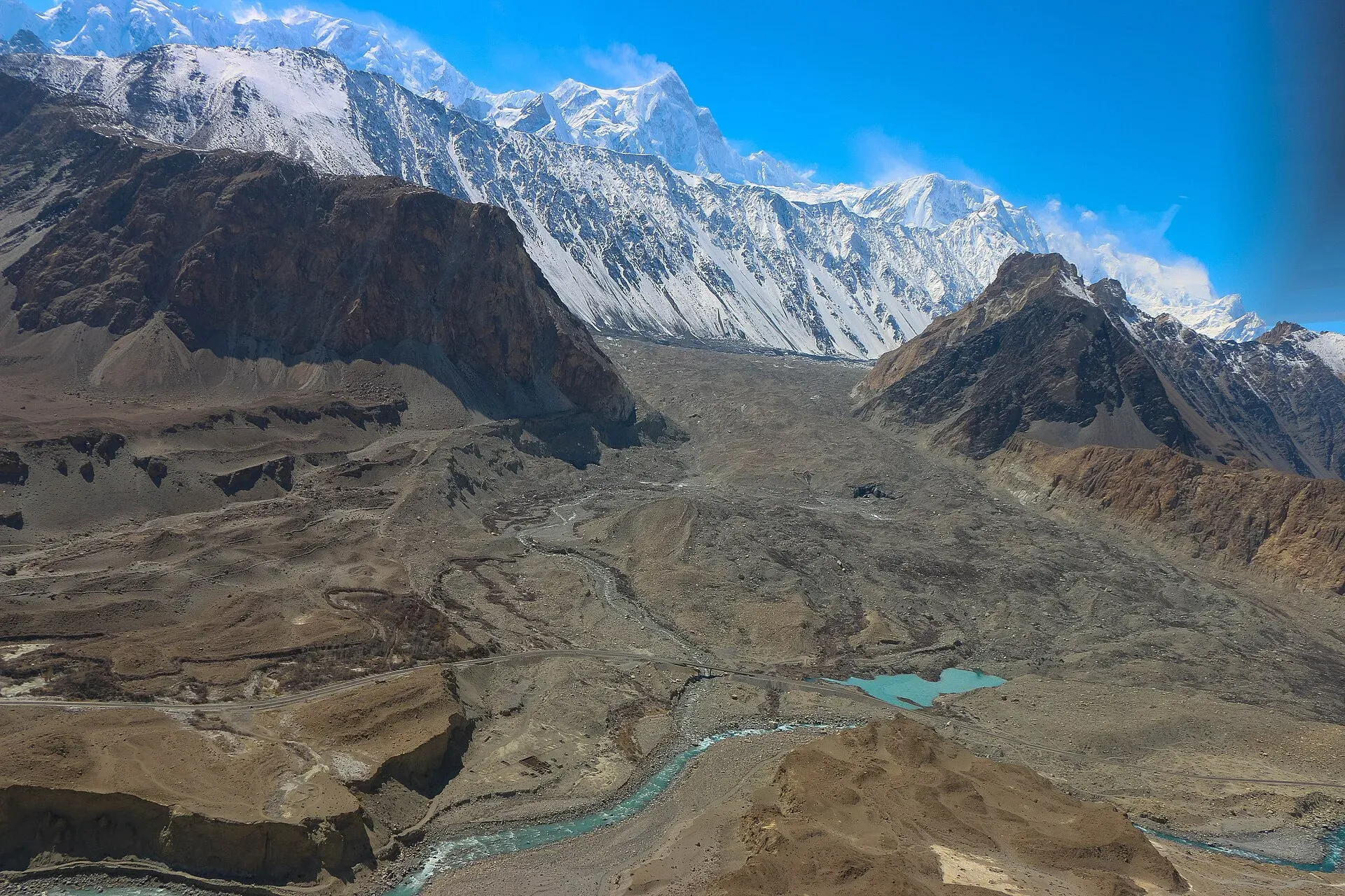
Photo: Akbar Khan Niazi, with thanks · CC BY-SA 3.0 · via Wikimedia Commons · temporary stand-in photo

Werthum Pass
- Duration
- 7 days
- Distance
- 52.4 km
- Grade
- Technical
- Max altitude
- 5,147 m
- Season
- Jun – Sep
A rugged seven-day crossing of Werthum Pass (5,147 m) from the Batura Glacier near Passu to the Lupgar valley in Chapursan. Basic ice skills are needed to cross a cornice on the north side.
Overview
Werthum means "millstone" in Wakhi. Werthum Pass (5,147 m) is a rarely crossed rock-and-scree pass that links the upper Batura Glacier with the Lupgar valley, a side valley of Chapursan. The trek starts at China Camp on the Karakoram Highway near Passu and ends at Raminj in Chapursan. It is a mountaineer's route through valleys few trekkers visit. The pass itself is not technically hard, but it needs basic mountaineering skills. From the top you see the six Batura peaks and Shishpar.
Who it suits
Experienced trekkers with basic ice skills. The north side of the pass has a permanent ice cornice, 3 to 4 m high, that you cut through with an ice axe on a rope belay. The descent to Harkeesh is 1,658 m. If you want to climb, the Werthum valley and the Shireen Maidan Glacier have easy snow peaks and technical peaks from about 5,400 m to 5,900 m.
When to go
Mid-June to September. The pass is harder before mid-July, when there is more snow and a bigger cornice. Rockfall danger is high in the early season, on the scree at the start of the Werthum valley.
The route
The first two days follow the Batura Glacier trek from China Camp to Yashpirt. On day 3 you reach the Batura margin at Shilmin, turn into the Werthum valley, climb scree, and pass the birch and juniper at Furzeen, where ibex are common. You cross the Werthum Nala on two large boulders and camp at Shireen Maidan (3,888 m), by a blue-green lake under the glacier.
Day 4 is a short, steep day above the gorge, past the rock face of Dzug Band, to Werthum Base Camp (4,363 m), a broad grassy plateau. Day 5 climbs to Werthum High Camp (4,975 m) on a rocky terrace below the pass. Water comes from afternoon snowmelt.
Day 6 is the pass. From the high camp you reach the pass in 45 minutes. You break the cornice, descend talus to a small glacier and a stream, and follow the valley down to Shikar Gah (4,285 m), a canyon with ibex above. A boulder-choked gorge follows, where you walk in the water. In very high water it may be impassable. After about two hours you reach pastures, a natural stone bridge and the green oasis of Harkeesh (3,489 m).
Day 7 follows the valley to the Lupgar village of Raminj (3,095 m).
The Batura Glacier approach
Days 1 and 2 follow the Batura Glacier, which is about 57 km long and flows west to east beside the Karakoram Highway. Wikipedia describes the middle and lower glacier as buried under thick rock debris, with only a narrow strip of clean ice near the snout. Expect to walk on moraine (loose glacial rubble) and on scree beside the ice, not on bare ice. The Passu massif (about 7,500 m) lies south of the glacier and the Batura massif (7,795 m) to the north. The glacier has retreated since the 1980s, so old descriptions of the first camps may not match the ground.
Underfoot, in order
Scree and a boulder crossing of the Werthum Nala (day 3), a yak trail above a gorge and a rock-hop along the river (day 4), steep scree to a rocky terrace (day 5), then a cornice, talus, a small glacier, a boulder gorge walked in the water and finally a good valley trail (days 6 and 7). Wet boots are likely on day 6.
Preparation
The route is rarely used, so fitness and self-reliance matter more than on a popular trek. You camp at 4,363 m and 4,975 m before crossing 5,147 m, so build in acclimatisation days on the Batura approach. Practise cutting steps and belaying with an ice axe before you go. Carry tarps for porters, a satellite messenger and insurance that covers helicopter evacuation.
Another crossing into Raminj
Wikipedia lists the Lupghar Pir Pass (5,190 m, uncited) between Yashkuk and Raminj. It is a separate trek that ends in the same village.
Culture and people
The route starts among the Wakhi and Burushaski villages of Passu and ends in Raminj, in Chapursan, home of the mountaineer Nazir Sabir. The guidebook authors opened this route in July 2000 with Passu men, and only a handful of local men knew it at the time. Hire men who know the way. Harkeesh means "place of cultivation" in Burushaski. Expect few other trekkers.
Practical information
A local guide and porters are essential. Only a few Passu men knew the pass when the route was opened. If you cross north to south, hire men from Raminj or Khaibar, though it may be hard to find porters willing to do the steeper side. Bring a tarp or tent for porters, since there are no huts for two nights between Kukhil and Harkeesh.
The Swiss Karakoram map gets the trail between Shireen Maidan and Werthum Base Camp wrong: it is on the opposite side of the river from where it is drawn. Werthum Pass and Harkeesh do not appear on it, and the glacier on the north side is much smaller than shown.
Raminj lies in Chapursan, beyond the Afiyatabad check post, so carry your passport. Porters from Passu may ask for 11 stages from Passu to Raminj, though the guidebook counts ten.
Highlights
- Rarely crossed pass with views of the six Batura peaks and Shishpar
- Ibex at Furzeen, Shikar Gah and the Shireen Maidan Glacier
- Easy and technical climbing peaks around the Werthum valley
- Descent through a boulder gorge to the oasis of Harkeesh
Day by day
| Day | Camp | Altitude |
|---|---|---|
| 1 | Uzhokpirt | not given |
| 2 | Yashpirt | not given |
| 3 | Shireen Maidan | 3,888 m |
| 4 | Werthum Base Camp | 4,363 m |
| 5 | Werthum High Camp | 4,975 m |
| 6 | Harkeesh | 3,489 m |
| 7 | Raminj | 3,095 m |
| Day | Route | Hours | Distance | Ascent / descent | Camp and altitude |
|---|---|---|---|---|---|
| Day 1 | China Camp to Uzhokpirt | not given | not given | not given | not given |
Day 1 notesFollow the Batura Glacier trek from China Camp on the highway through Yunzben to the glacier margin. This part of the route is described in the Batura Glacier trek and has not been re-checked here. The guidebook gives a total of 16.6 km and 872 m of ascent for days 1 and 2 together. | |||||
| Day 2 | Uzhokpirt to Yashpirt | not given | not given | not given | not given |
Day 2 notesContinue up the Batura Glacier's south side to the camp at Yashpirt. Both days use the Batura trail. Check with your guide for current campsites and glacier conditions. | |||||
| Day 3 | Yashpirt to Shireen Maidan | 6 h | 16.9 km | +586 m | Shireen Maidan, 3,888 m |
Day 3 notesWalk about 4½ hours to Shilmin, then turn up the Werthum valley. Climb scree to Furzeen, where ibex are often seen. Cross the Werthum Nala on two big boulders, or ford it when low. Camp at the confluence beside a clear stream. A deep blue-green lake lies 10 minutes east. Rockfall danger is high early in the season. | |||||
| Day 4 | Shireen Maidan to Werthum Base Camp | 3 h | 3.8 km | +475 m | Werthum Base Camp, 4,363 m |
Day 4 notesCross the river and climb a yak trail to grassy slopes high above the gorge. Pass three ravines and a difficult rock face called Dzug Band. Rock-hop along the river for 15 to 30 minutes, then ford it and climb to a cairn on a broad plateau. Water is in a ravine east of the stone shelter. Short day, so you can rest and acclimatise. | |||||
| Day 5 | Werthum Base Camp to Werthum High Camp | 3–4 h | 3.4 km | +612 m | Werthum High Camp, 4,975 m |
Day 5 notesFollow a faint yak trail high above the stream, then climb a steep scree and rock hillside. Cross to the barren upper basin below the pass and camp on a level terrace. Water trickles from afternoon snowmelt. A strong party that has acclimatised can skip the high camp and cross the pass in one long day. | |||||
| Day 6 | Werthum High Camp over Werthum Pass to Harkeesh | 6–7 h | 6.1 km | +172 m / −1,658 m | Harkeesh, 3,489 m |
Day 6 notesReach Werthum Pass (5,147 m) in 45 minutes. Belay and cut steps through the ice cornice on the north side, then descend talus and cross a small glacier. Follow the stream down through the canyon of Shikar Gah (4,285 m), then through a boulder gorge where you walk at the water's edge. After pastures and a natural bridge, descend to the grassy oasis of Harkeesh (3,489 m). | |||||
| Day 7 | Harkeesh to Raminj | 2½–3 h | 5.6 km | −394 m | Raminj, 3,095 m |
Day 7 notesDescend the Lupgar valley on a good trail to Raminj (3,095 m), a village in Chapursan. | |||||
Getting there
From Passu on the Karakoram Highway, China Camp is about 15 minutes' drive north, at the bridge over the Batura Glacier's stream. A tractor or jeep can take you there, or you can start on foot from Janabad.
Raminj is in Chapursan, so you leave by road through the valley towards Afiyatabad. Ask locally about current jeep transport, which we have not confirmed.
Permits and rules
- Permit needed
- Usually not, Open zone
- Fee
- Current fees will be added soon
- Last checked
- 16 November 2026
The old guidebook lists this trek as open, with no permit needed. The route ends in Chapursan, a border valley, and the Gilgit-Baltistan rules for foreigners have changed since the guidebook. Dawn reported in February 2026 that permit fees for foreign trekkers had risen sharply. We have not confirmed whether this route needs a permit. Ask a licensed operator or the GB tourism department before you go.
How trekking permits, NOCs and registration work: Visa and permits.
Season
Best: Jun – Sep
Water and camps
Water is good at Shireen Maidan (spring by the river) and Werthum Base Camp (small ravine east of the shelter). At Werthum High Camp it comes from afternoon snowmelt and may only trickle. Harkeesh gets canal water in the afternoon, and it can be dry by morning. There are no huts between Kukhil and Harkeesh. The Werthum Base Camp shelter is a single stone circle for porters. Bring tarps.
Gear and safety
Altitude: you sleep at 4,363 m and 4,975 m, then cross 5,147 m. Spend time on the Batura approach. Cornice: the north side of the pass has a permanent vertical cornice of 3 to 4 m, larger before mid-July. Use a rope belay and cut steps. Rope, ice axe and, going north to south, crampons are needed. Rockfall: severe at the Werthum valley entrance in early season, and on steep scree on both sides. River: the Werthum Nala is highest in the afternoon. The gorge below Shikar Gah may be impassable in very high water. There is no easy road access. Carry a satellite messenger, and insurance that covers helicopter evacuation.
Variations
The Werthum valley is a climbing area. Werthum Peak (5,844 m on the Swiss map) is a technical three-day climb from the base camp, and there are non-technical 5,300 to 5,500 m peaks near it. The Shireen Maidan Glacier has about a dozen 5,000 to 6,000 m summits. The Batura Glacier and Lupgar Pir Pass treks join this route at the start and the finish.
Tips
- Cross after mid-July, when the cornice is smaller.
- Bring a rope, ice axe and, going north to south, crampons.
- Bring a tarp or tent for porters. There are no huts between Kukhil and Harkeesh.
- Do not trust the Swiss map for the trail to Werthum Base Camp.
- Carry your passport. Chapursan is beyond the Afiyatabad check post.
Photos we still need: Werthum Pass, Shireen Maidan, Harkeesh or Raminj (no open-licence photo found). Send us yours
Health and emergency
Mobile signal is patchy on most treks, so tell someone your plan before you go. Emergency numbers
Sources and last checked
Last checked Confidence low5 sources7 still to check
- Last checked
- Method
- Desk research from published sources
- Confidence
- low
- Checked by
- trek.pk research team
Researched from published sources; not yet checked on the ground by our team. Spot something out of date? Report a mistake.
Sources
- Trekking in the Karakoram and Hindukush (Lonely Planet, ~2002), Gojal chapters; old trek.pk text · Lonely Planet / trek.pk archive · checked
- GB winter adventure tourism hit by soaring permit fee, visa delays · Dawn (1 Feb 2026) · checked
- List of Restricted/Prohibited/Border Areas in Pakistan · Apricot Tours (operator, undated) · checked
- Batura Glacier (length, debris cover, massifs, retreat) · Wikipedia · checked
- Chipursan (villages, Raminj, passes) · Wikipedia · checked
Still to be checked on the ground (7)
- Current permit rules: guidebook says open, but Chapursan is a border area and some operators list it as restricted (no official source found)
- Whether the route is still used and which local guides know it (first opened July 2000 by the guidebook authors)
- Pass height 5,147 m and cornice condition: from the 2002 guidebook only
- Current distances, timings, campsites and the state of the Batura Glacier trail
- Road and transport from Raminj
- Days 1 and 2 detail (China Camp to Yashpirt) was in a separate guidebook chapter and has not been checked here
- Raminj is a Burusho village per Wikipedia; Lupghar Pir Pass height of 5,190 m is uncited there
Nearby and related

Chilinji An and Qalander Uween

Other treks in Gojal

Asumbar Haghost
Werthum Pass
A rarely crossed pass of 5,147 m linking the Batura Glacier near Passu with the Lupgar valley. Basic ice skills needed for a cornice.
Lupgar Pir Pass
A non-glaciated pass of 5,190 m linking Yishkuk in Chapursan with Raminj in the Lupgar valley. Six very demanding days.