

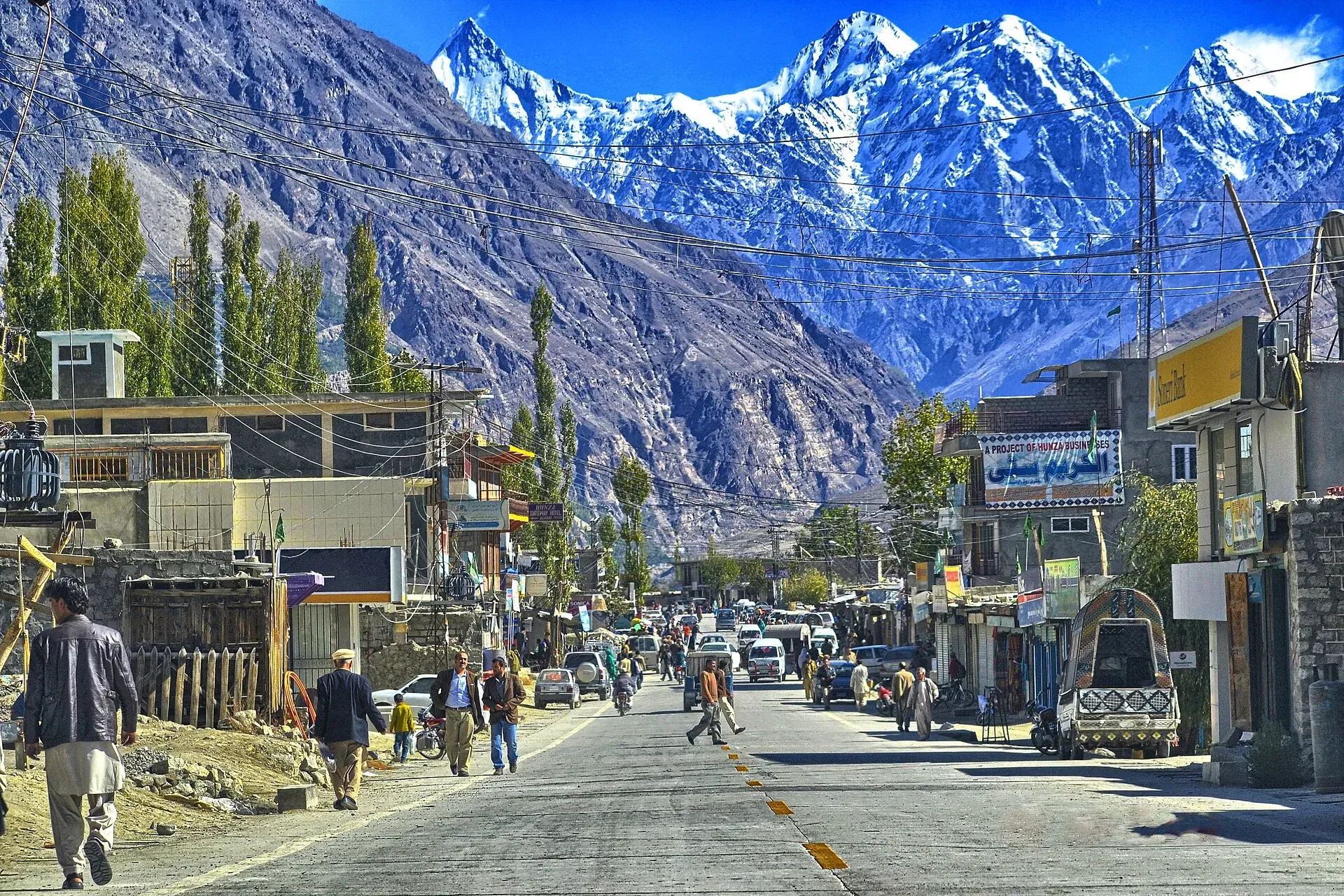
Photo: Gudupk, with thanks · CC BY-SA 3.0 · via Wikimedia Commons · temporary stand-in photo

Aliabad (Hunza)
The commercial hub of Hunza, on the Karakoram Highway about 9 km from Karimabad, with the main bazaar, transport offices and a base for Hunza and Nagar.
Overview
Aliabad is the administrative and commercial centre of Hunza, according to Wikipedia. It lies at about 2,206 m on the Karakoram Highway between two forks of the Hunza River. Hunza District was created in 2015, and Wikipedia's district article says its headquarters is Baltit (Karimabad). Wikipedia's Hunza District article says the district has three tehsils (administrative subdivisions): Shinaki, Aliabad and Gojal. Aliabad tehsil covers the villages of lower and central Hunza, and the district headquarters is Baltit (Karimabad). Treat Aliabad as the main bazaar and transport hub, and confirm which offices are where locally. The 2023 population of Hunza District was 65,497 (Wikipedia). There is no known town-level figure.
Plan your visit
- Nearest town
- Aliabad
- Getting there
Road: about 94 km from Gilgit (OSRM about 1 h 10 min, optimistic) on the KKH, about 9 km to Karimabad (about 12 min) and about 96 km to Sost. More
Best months
Apr – Oct
- Aliabad (Hunza)
- Related places nearby: Karimabad (Hunza), Baltit Fort, Altit Fort, Nagar Valley, Gilgit
What to see and do
Aliabad is a stop for shopping, buses and onward travel. The surrounding villages are close: Baltit and Altit forts are a short drive, and Ganish village is nearby. Nagar valley is just across the river. Wikipedia places Hassanabad to the west, Murtazaabad to the south, and Baltit Fort, Altit Fort and Ganish to the east. Wikivoyage calls it the main business hub, with hotels and shops along the highway, and adds that minibuses leave for Gilgit about every 30 minutes (undated). Bus companies run services from here to Gilgit, Rawalpindi and Karachi (Wikipedia).
Getting there
- From Gilgit: about 94 km, OSRM about 1 hour 10 minutes (optimistic).
- To Karimabad: about 9 km, OSRM about 12 minutes.
- To Sost: about 96 km, OSRM about 1 hour 40 minutes.
- Buses and vans run on the KKH from Gilgit.
Languages
Wikipedia's district article says Burushaski dominates central Hunza, Shina is the main language of lower Hunza and Wakhi that of upper Hunza. Aliabad itself is in the central part.
When to visit
Aliabad has a cold desert climate with little rain (about 125 mm a year). July is the warmest month (average 23.6 C), January the coldest (-3.0 C), and May the wettest (29 mm). Spring and autumn are most popular. Winter is cold.
Where to stay and eat
Hotels and guesthouses are in Aliabad and especially in nearby Karimabad. Restaurants serve Hunza dishes and standard Pakistani food.
Basic services
As the commercial centre, Aliabad is likely to have the valley's main shops and clinics. Hospitals, pharmacies, fuel stations and ATMs are normal in a district headquarters, but we have not confirmed any of them for this town from an official source. Ask at your hotel, and use the business listings on this site.
Safety and good to know
For foreign visitors: the UK FCDO (updated 27 October 2026, checked 16 November 2026) does not advise against Gilgit-Baltistan in general, and does not name Hunza. This is government advice. Check the page, road news and weather, especially in the monsoon.
Highlights
- Main bazaar and transport hub of Hunza
- Close to Baltit and Altit forts
- On the Karakoram Highway
Stay, eat and essentials near Aliabad (Hunza)
Within 8 km of Aliabad (Hunza), nearest first.
Places to stay
- The2Magpies, HunzaCall The2Magpies, HunzaMap of The2Magpies, Hunza in Google Maps
- Hunza ElitesCall Hunza ElitesMap of Hunza Elites in Google Maps
- Jubilee HotelCall Jubilee HotelMap of Jubilee Hotel in Google Maps
- Hunza City HotelCall Hunza City HotelMap of Hunza City Hotel in Google Maps
- Rustam Palace HotelMap of Rustam Palace Hotel in Google Maps
- Arcadian Inn HotelMap of Arcadian Inn Hotel in Google Maps
Places to eat
- Pizza Pamir AliabadCall Pizza Pamir AliabadMap of Pizza Pamir Aliabad in Google Maps
- Hunza GateWay hotelMap of Hunza GateWay hotel in Google Maps
- Shinwari Restaurant Aliabad HunzaCall Shinwari Restaurant Aliabad HunzaMap of Shinwari Restaurant Aliabad Hunza in Google Maps
- Lazzat Restaurant HunzaCall Lazzat Restaurant HunzaMap of Lazzat Restaurant Hunza in Google Maps
- Rewayat Restaurant Ganish HunzaCall Rewayat Restaurant Ganish HunzaMap of Rewayat Restaurant Ganish Hunza in Google Maps
- SIPS & BITESCall SIPS & BITESMap of SIPS & BITES in Google Maps
Essential services fuel stations, ATMs, banks, pharmacies and hospitals and clinics
Fuel
- PSO PumpMap of PSO Pump in Google Maps
- PSO Pump NoorshahMap of PSO Pump Noorshah in Google Maps
- Attock - Silk Route Filling StationMap of Attock - Silk Route Filling Station in Google Maps
- Passu Petrol Filling StationMap of Passu Petrol Filling Station in Google Maps
- Caltex Techron Petrol Pump by Be EnergyCall Caltex Techron Petrol Pump by Be EnergyMap of Caltex Techron Petrol Pump by Be Energy in Google Maps
- Attock Petrol PumpMap of Attock Petrol Pump in Google Maps
ATMs
- Bank AlfalahCall Bank AlfalahMap of Bank Alfalah in Google Maps
- Habib Metro Bank AliabadCall Habib Metro Bank AliabadMap of Habib Metro Bank Aliabad in Google Maps
- Habib Bank Limited (HBL)Call Habib Bank Limited (HBL)Map of Habib Bank Limited (HBL) in Google Maps
- National Bank ATMMap of National Bank ATM in Google Maps
Banks and money exchange
- Karakorum Cooperative BankMap of Karakorum Cooperative Bank in Google Maps
- First Micro BankMap of First Micro Bank in Google Maps
- Soneri Bank LtdCall Soneri Bank LtdMap of Soneri Bank Ltd in Google Maps
- The Aliabad Co.op Thrift & Credit Society Ltd Agakhan Abad Branch HunzaCall The Aliabad Co.op Thrift & Credit Society Ltd Agakhan Abad Branch HunzaMap of The Aliabad Co.op Thrift & Credit Society Ltd Agakhan Abad Branch Hunza in Google Maps
Pharmacies
- Sana MedicosMap of Sana Medicos in Google Maps
Hospitals and clinics
- Aliabad Civil HospitalMap of Aliabad Civil Hospital in Google Maps
- Hunza ClinicsCall Hunza ClinicsMap of Hunza Clinics in Google Maps
- Govt Civil Hospital AskurdasMap of Govt Civil Hospital Askurdas in Google Maps
Listings come from Google Maps data and are unverified: phone numbers, opening months and prices may have changed. Report a problem · Own one of these? Claim it
Tips
- Check road news for landslides before travelling on the KKH.
- Use Aliabad for cash and supplies before Gojal.
- Allow time in spring for apricot blossom.
- Winters are cold; many hotels close.
Photos we still need: Aliabad bazaar on the Karakoram Highway. Send us yours
Sources and last checked
Last checked Confidence medium5 sources3 still to check
- Last checked
- Method
- Desk research from published sources
- Confidence
- medium
- Checked by
- trek.pk research team
Researched from published sources; not yet checked on the ground by our team. Spot something out of date? Report a mistake.
Sources
- Aliabad, Hunza · Wikipedia · checked
- Hunza District · Wikipedia · checked
- Pakistan travel advice (updated 27 October 2026) · UK Foreign, Commonwealth & Development Office · checked
- OSRM driving route service: distances and times measured 16 November 2026 (times are optimistic, without stops) · OSRM / OpenStreetMap · checked
- Hunza Valley travel guide · Wikivoyage · checked
Still to be checked on the ground (3)
- Which town houses district offices: Wikipedia's Aliabad article calls Aliabad the administrative centre, but its Hunza District article names Baltit (Karimabad) as headquarters; no official source found
- Services and bank branches
- Hotel seasons
Nearby and related

Karimabad (Hunza)
The main town of Hunza, set on a terrace below Baltit Fort with Rakaposhi, Ultar and Diran in view. A good base for forts, viewpoints, Attabad Lake and the road to Gojal.

Baltit Fort
A restored fort and museum above Karimabad in Hunza, once the home of the Mirs of Hunza. Its core is centuries old and it has been on UNESCO's tentative list since 2004.

Altit Fort
An old fort above the Hunza River at Altit, restored by the Aga Khan Trust for Culture and open to visitors since 2007. Often described as the oldest monument in Gilgit-Baltistan.

Nagar Valley
The quieter bank of the Hunza River, facing Karimabad: Minapin, Hoper and Hispar villages, Rakaposhi viewpoints and easy treks below Rakaposhi, Diran and Spantik.

Gilgit
Gateway to Gilgit-Baltistan on the Karakoram Highway: a busy mountain town with the Kargah Buddha and the base for Hunza, Naltar and Skardu.

Gilgit-Baltistan
Pakistan's far north: three great ranges meet here, with K2, Nanga Parbat, giant glaciers, the Karakoram Highway and the valleys of Hunza, Skardu and Gilgit.
Hunza and Khunjerab (KKH)
A 7-8 day road trip from Islamabad up the Karakoram Highway to Hunza and on to Khunjerab Pass (4,693 m), with overnight stops at Besham, Chilas and Gilgit.