

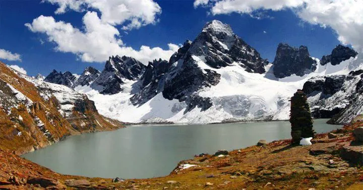
Photo: Luqman Yousafzai, with thanks · CC BY-SA 4.0 · via Wikimedia Commons · temporary stand-in photo

Chitta Katha Lake
A high alpine lake in the Shounter valley of upper Neelum, Azad Kashmir, reached by a jeep track from Kel and then a short walk. Remote and close to the Line of Control.
Overview
Chitta Katha Lake is an alpine glacial lake in the Shounter valley, a side valley of the upper Neelum Valley in Azad Kashmir. Wikipedia gives its height as about 4,100 m (13,500 ft). Nature Adventure Club gives 3,962 m (12,999 ft). By either figure the lake lies roughly 1,900 to 2,000 m above Kel, where the road ends (2,097 m), and about 860 to 1,000 m above Shounter Lake (about 3,100 m).
Nature Adventure Club says the lake is the source of a stream of the same name, and translates the name as "White Stream". Published information is short: two entries agree on the access, and no walking time, camp or landmark list has been found.
Plan your visit
- Nearest town
- Kel
- Getting there
Drive from Muzaffarabad up the Neelum Valley to Kel, about 150 to 155 km. From Kulga Kel a jeep track of about 20 km leads up the Shounter valley, then a track of about 5 km on foot reaches the lake. More
- Chitta Katha Lake
- Related places nearby: Shounter Lake, Kel Camping (Neelum), Neelum Valley, Sharda
The Shounter valley
The Shounter valley is a smaller valley within the Neelum Valley, on the Azad Kashmir side of the Line of Control. Lower down it holds Shounter Lake, a glacial lake fed by melt, with Iris hookeriana growing around its shore. From the same valley a separate high crossing, the Shounter Pass, leads towards Astore in Gilgit-Baltistan; see the Shounter Lake page.
The Neelum Valley itself runs for about 144 km along the Neelum River, with mountains rising on both sides to about 5,200 m. Other lakes in the valley are reached from different roadheads. Ratti Gali Lake, for example, is approached from Dowarian and is a separate trip. See the Neelum Valley page.
Getting there
Kel is about 150 to 155 km from Muzaffarabad by road. Most visitors leave a car at Keran or Sharda and hire a local jeep for the rough road beyond. A Dawn writer put the jeep ride from Sharda to Kel at about two hours. The same article describes a road wide enough for one vehicle, regular landslides, and army traffic because Kel is close to the Line of Control. See Kel for the village.
The route
Both sources describe the same two stages. Wikipedia says that from Kulga Kel a jeep track of about 20 km leads up the Shounter valley, followed by a tourist track of about 5 km. Nature Adventure Club says that from Kel base camp a 20 km jeep road narrows into a 5 km trekking trail to the lake. That is about 25 km from Kel in all.
The same 20 km and 5 km figures are quoted for the route to Shounter Lake, where operators put the jeep stage at two to three hours and the walk at three to five hours. Whether the two lakes share one track is not made clear, and no times are published for Chitta Katha itself. No source describes the terrain underfoot, river crossings, camps or landmarks, so none are given here.
When to visit
No source gives dates for Chitta Katha. For Shounter Lake, lower in the same valley, Wikipedia lists May to August and Nature Adventure Club says the jeep track is usable only from June to August, once the ice melts. Ask in Kel or Sharda about snow and track conditions before leaving.
Preparation
The lake is about 1,900 to 2,000 m higher than Kel. Spend a night at Kel first and go up slowly. There is no accommodation at the lake, so bring a tent, food and a way to treat water. Hire a registered jeep with a licensed driver and a local guide in Kel. Rescue is slow and mobile coverage is poor.
Where to stay and eat
Kel has basic hotels and guesthouses, a bazaar and a tehsil hospital, with more choice at Sharda and Keran. Wikipedia says a rest house run by the AJK Tourism and Archaeology Department also serves visitors at Kel. Camping above the lake is arranged locally with an operator.
Good to know
- Line of Control: The valley is close to it. Ask the district administration or the tourism office in Kel about permission and closures.
- Vehicle: Use a registered jeep with a licensed driver.
- Fees: Any permit, guide, jeep or camping charges are set locally. Current fees will be added soon.
Travel advice
For foreign visitors: the UK FCDO advises against all but essential travel to Azad Jammu and Kashmir, and against all travel within 10 miles of the Line of Control (advice updated 27 October 2026, checked 17 November 2026). Read the live advice before you plan.
Highlights
- Alpine glacial lake in the Shounter valley
- About 20 km by jeep from Kel, then about 5 km on foot
- Source of a stream of the same name (the "White Stream")
- Higher than Shounter Lake
Tips
- Arrange a jeep and guide in Kel
- Check permission and track conditions locally
- Bring tents and food; there is no accommodation
Photos we still need: the jeep track and walking trail up the Shounter valley; the lake shore and camping area. Send us yours
Sources and last checked
Last checked Confidence low9 sources6 still to check
- Last checked
- Method
- Desk research from published sources
- Confidence
- low
- Checked by
- trek.pk research team
Researched from published sources; not yet checked on the ground by our team. Spot something out of date? Report a mistake.
Sources
- Chitta Katha Lake · Wikipedia · checked
- List of lakes of Pakistan · Wikipedia · checked
- Pakistan travel advice · UK FCDO · checked
- Lakes of Pakistan · Nature Adventure Club · checked
- Kel, Azad Kashmir · Wikipedia · checked
- Shounter Lake · Wikipedia · checked
- Neelum Valley · Wikipedia · checked
- Kel and Arang Kel · Dawn · checked
- Ratti Gali Lake · Wikipedia · checked
Still to be checked on the ground (6)
- Altitude: sources give about 3,962 m and 4,100 m
- Walking time and terrain on the 5 km track
- Whether the 20 km jeep and 5 km walk quoted for Chitta Katha are the same route as the one quoted for Shounter Lake
- Best months for Chitta Katha itself
- Permission requirements near the Line of Control
- Current jeep and camping charges
Nearby and related

Chitta Katha Lake Trek (Shounter Valley)

Shounter Lake
A glacial lake at about 3,100 m in the remote Shounter valley above Kel in Neelum. A rough jeep track from Kel is followed by a hike.

Kel Camping (Neelum)
Kel is a village in the upper Neelum Valley and the base for the Arang Kel chairlift and the Shounter Lake trips. Tent camps are common nearby, but the area is close to the Line of Control and UK advice is against travel.

Neelum Valley
A long, forested river valley in Azad Kashmir running north-east from Muzaffarabad to Sharda, Kel and Arang Kel. It runs close to the Line of Control, so check access before you go.

Sharda
A small town in the upper Neelum Valley of Azad Kashmir at about 1,981 m, known for the ruins of the Sharada Peeth temple site. It is close to the Line of Control, and official travel advice is strict.
Neelum Valley
A 4-5 day road trip from Islamabad to Muzaffarabad and up the Neelum River by Athmuqam, Keran, Sharda and Kel, about 275 km, with a jeep track beyond Kel. Check current advice: the valley runs close to the Line of Control.