

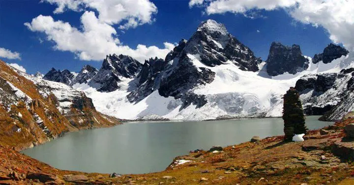
Photo: Luqman Yousafzai, with thanks · CC BY-SA 4.0 · via Wikimedia Commons · temporary stand-in photo

Chitta Katha Lake Trek (Shounter Valley)
- Duration
- 1–2 days
- Grade
- Moderate
- Max altitude
- 4,100 m
A trek in the Shounter valley above Kel to Chitta Katha Lake, an alpine lake at about 4,000 m. Wikipedia gives a 20 km jeep track from Kulga Kel and a 5 km tourist track on foot.
Overview
Chitta Katha Lake is an alpine lake in the Shounter valley, a side valley of the upper Neelum Valley. Wikipedia gives its height as 4,100 m (13,500 ft). Nature Adventure Club gives 3,962 m (12,999 ft), so the figure varies by about 140 m. It lies higher up the valley than Shounter Lake, which Wikipedia puts at 3,100 m.
The route
Two sources describe the access in the same terms. Wikipedia says that from Kulga Kel there is a 20 km (12 mi) jeep track followed by a 5 km (3.1 mi) tourist track. Nature Adventure Club says that from Kel base camp a 20 km jeep road narrows into a 5 km trekking trail to the lake. Neither source gives times, camps, or landmarks along the track.
Kel is a village on the Neelum road beyond Athmuqam. See Kel for the village and its camping area. The Shounter Lake track starts here as well, so the two lakes are often discussed together.
Preparation
No source gives the walking time or the camps, so a first visit needs a local guide and a registered jeep with a licensed driver. Arrange them in Kel. Rescue is slow and mobile coverage is poor, according to our place page. Carry food, water treatment and a tent, as there is no accommodation at the lake.
When to go
No source gives dates. Shounter Lake is listed by Wikipedia as visited from May to August, and snow can close the track and the upper valley for much of the year. Ask in Kel or Sharda for current conditions.
Practical information
- Check permission and closures near the Line of Control with the district administration or the tourism office in Kel.
- Fees for guides, jeeps and camping are set locally. Current fees will be added soon.
- Go up slowly. The lake is at about 4,000 m.
Highlights
- Alpine lake in the Shounter valley
- Long jeep track from Kulga Kel followed by a short trek
- Sits above Shounter Lake
Day by day
- StartKulga Kel (jeep track up the Shounter valley)
- Day 1Chitta Katha Lake
| Day | Route | Hours | Distance | Ascent / descent | Camp and altitude |
|---|---|---|---|---|---|
| Day 1 | Kulga Kel to Chitta Katha Lake | not confirmed | 25 km | not given | Chitta Katha Lake, 4,100 m |
Day 1 notesTake a jeep up the Shounter valley for about 20 km, then follow the trekking trail for about 5 km to the lake. No source gives the time or landmarks. Whether it is a day trip or an overnight depends on the jeep and the conditions, so ask in Kel. | |||||
Getting there
Drive from Muzaffarabad up the Neelum Valley to Kel. From Kulga Kel a jeep track of about 20 km leads up the Shounter valley, then a trekking trail of about 5 km reaches the lake. Times are not confirmed.
Permits and rules
- Permit needed
- Check
- Fee
- Current fees will be added soon
- Last checked
- 17 November 2026
No confirmed fee or permit was found. The valley is near the Line of Control: ask the district administration or the tourism office in Kel about permission and closures. Current fees will be added soon.
How trekking permits, NOCs and registration work: Visa and permits.
Water and camps
There is no accommodation at the lake. Stay in Kel or Sharda and camp with your own tent for any night out. Treat water before drinking.
Gear and safety
Remote area
Rescue is slow and mobile coverage is poor. Tell someone in Kel your plan.
Vehicle
Use a registered jeep with a licensed driver.
Altitude
The lake is at about 4,000 m. Go up slowly.
Ask the district administration or local police about current conditions before you go. For foreign visitors: the UK FCDO advises against all but essential travel to Azad Jammu and Kashmir, and against all travel within 10 miles of the Line of Control (advice updated 27 October 2026, checked 17 November 2026). Read the live advice before you plan.
Variations
Shounter Lake lies lower in the same valley and is reached from Kel by a jeepable track.
Tips
- Arrange a guide and registered jeep in Kel
- Ask about permission before you set out
- Carry a tent, food and water treatment
- Acclimatise before going to about 4,000 m
Photos we still need: the jeep track and the walk to Chitta Katha Lake. Send us yours
Health and emergency
Mobile signal is patchy on most treks, so tell someone your plan before you go. Emergency numbers
Sources and last checked
Last checked Confidence low4 sources7 still to check
- Last checked
- Method
- Desk research from published sources
- Confidence
- low
- Checked by
- trek.pk research team
Researched from published sources; not yet checked on the ground by our team. Spot something out of date? Report a mistake.
Sources
- Chitta Katha Lake · Wikipedia · checked
- Shounter Lake · Wikipedia · checked
- Top lakes of Pakistan · Nature Adventure Club · checked
- Pakistan travel advice · UK FCDO · checked
Still to be checked on the ground (7)
- Walking time on the 5 km track and jeep time on the 20 km track
- Lake height: 4,100 m (Wikipedia) or 3,962 m (Nature Adventure Club)
- Whether the walk starts at Kulga Kel or beyond the jeep track
- Best months and permission rules near the Line of Control
- Camps on or near the route
- Current guide, jeep and camping charges
- Grade (no source; moderate is an estimate)
Nearby and related

Other treks in Diamir

Arang Kel Trail

Ganga Choti Trail

Chitta Katha Lake
A high alpine lake in the Shounter valley of upper Neelum, Azad Kashmir, reached by a jeep track from Kel and then a short walk. Remote and close to the Line of Control.

Shounter Lake
A glacial lake at about 3,100 m in the remote Shounter valley above Kel in Neelum. A rough jeep track from Kel is followed by a hike.

Kel Camping (Neelum)
Kel is a village in the upper Neelum Valley and the base for the Arang Kel chairlift and the Shounter Lake trips. Tent camps are common nearby, but the area is close to the Line of Control and UK advice is against travel.

Neelum Valley
A long, forested river valley in Azad Kashmir running north-east from Muzaffarabad to Sharda, Kel and Arang Kel. It runs close to the Line of Control, so check access before you go.

Sharda
A small town in the upper Neelum Valley of Azad Kashmir at about 1,981 m, known for the ruins of the Sharada Peeth temple site. It is close to the Line of Control, and official travel advice is strict.