

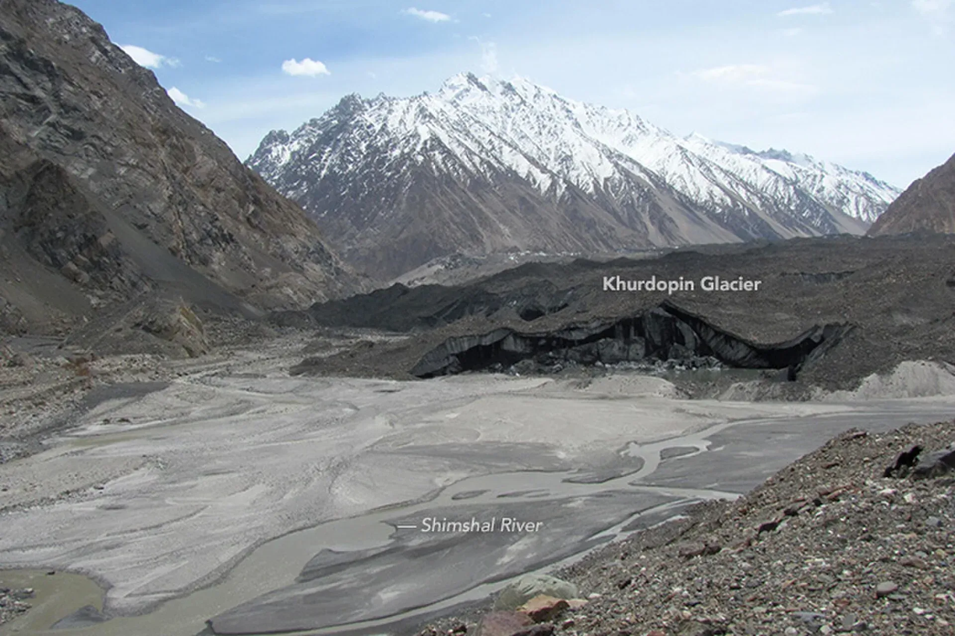
Photo: Waheed Anwar and NASA Earth Observatory, with thanks · Public domain (CC0) · via Wikimedia Commons · temporary stand-in photo

Khurdopin Pass
An extreme glacier pass of about 5,790 m from Shimshal to Lukpe Lawo, first crossed in 1986. For experienced mountaineers only.
Overview
Khurdopin Pass is a glaciated pass of about 5,790 m in the Karakoram. It links Shimshal with Lukpe Lawo, another name for Snow Lake, the glacial basin at the head of the Biafo and Hispar glaciers (see Biafo Glacier). An older guidebook calls it an extreme alpine Grade III mountaineering route, first crossed in 1986. Wikipedia's Shimshal article says the pass remains a favourite with trekkers.
Height. The 5,790 m figure comes from the guidebook only.
Plan your visit
- Nearest town
- Shimshal
- Getting there
There is no road to the pass. Shimshal is reached by a rough jeep road from the Karakoram Highway near Passu; there is no public transport. The far end, Lukpe Lawo, is a remote camp on the Biafo Glacier. More
- Khurdopin Pass
- Related places nearby: Khurdopin Glacier (Shimshal), Gojal and Shimshal
Crossing the pass
The route crosses the 37 km Khurdopin Glacier, an icefall and a 50-degree ice wall, with avalanche danger. It is only for experienced mountaineers. A glacier study published in 2018 (Steiner and others, in The Cryosphere) gives the glacier's length as about 41 km and its width as about 1.5 km, running from about 3,300 m in the Shimshal valley up to 7,760 m. The lower 10 km of the tongue is heavily covered in debris. No published route description of the pass itself, its camps or its terrain beyond this was found.
Starting from Shimshal
Shimshal is the last village before the glacier. At about 3,113 m it is the highest settlement in Hunza District. Its people are Wakhi speakers of the Ismaili tradition, and the village has produced well-known mountaineers.
There is only one road in. It leaves the Karakoram Highway about 5 km north of Passu and is about 55 km long (Wikivoyage; Wikipedia says 56 km and dates its completion to October 2003). It is a 4x4 track, one vehicle wide for most of its length, with sections cut into cliffs. Wikivoyage says floods had destroyed some bridges by 2019, so there are small river crossings. Jeeps run daily between Passu and Shimshal, and the journey takes about 2.5 hours. A police post at the start of the road, just after the suspension bridge over the Hunza River, is where foreigners sign in. See Passu and the Gojal and Shimshal page.
Surges and the 2017 lake
Khurdopin is a surge-type glacier. It speeds up sharply for a short time after years of quiet build-up, and the study records surges in 1979, 1999 and 2017. Peak speeds reached about 5,200 m a year in early June 2017, among the fastest recorded for a mountain glacier. By September most of the ice was moving below 200 m a year.
During surges the tongue blocks the Vijerab River and forms a lake. In 2017 the lake grew from about May and drained from around 21 July. The outflow washed away the road in several places, destroyed at least one main bridge and cut the valley off for about a week. The authors warned that a future lake could be larger. The glacier surged in 2016-17 in Wikipedia's account, while the study dates the rapid surge to 2017. The current state of the route is not confirmed. Check the river and glacier with Shimshal villagers before planning anything here.
When to go
The guidebook gives no season. Ask a licensed operator.
Permits and safety
Permits. Rules and fees for foreign trekkers in Gilgit-Baltistan changed in 2024 and were later contested. Dawn reported in February 2026 that mountaineering and trekking permit fees for foreigners had risen sharply, though it gave no figures, and that mountaineering and trekking visas are issued only after permits are obtained through Pakistani tour operators. The older guidebook says open; an operator list dated 14 January 2026 treats Shimshal-area routes as restricted (supporting only). Which applies is not confirmed, so book through a licensed Pakistani operator and ask for the permit requirements in writing. Current fees will be added soon.
Foreigners should read the UK FCDO travel advice for Pakistan, including its list of areas it advises against travel to, before planning any trip near the border.
Treks that cross it
- Other treks in Gojal: Khurdopin Pass section.
Highlights
- Extreme crossing of about 5,790 m
- Links Shimshal to the Biafo Glacier
Getting there
There is no road to the pass. Shimshal is reached by a rough jeep road from the Karakoram Highway near Passu; there is no public transport. The far end, Lukpe Lawo, is a remote camp on the Biafo Glacier.
Tips
- Only for experienced mountaineers
- Ask about the glacier's current state before you book
Photos we still need: the Khurdopin Pass summit and the Snow Lake (Lukpe Lawo) side. Send us yours
Sources and last checked
Last checked Confidence low7 sources5 still to check
- Last checked
- Method
- Desk research from published sources
- Confidence
- low
- Checked by
- trek.pk research team
Researched from published sources; not yet checked on the ground by our team. Spot something out of date? Report a mistake.
Sources
- Other treks in Gojal (old trek.pk page, text from Lonely Planet, c. 2002; facts only) · trek.pk · checked
- GB winter adventure tourism hit by soaring permit fee, visa delays · Dawn (1 Feb 2026) · checked
- Foreign travel advice: Pakistan · UK Foreign, Commonwealth and Development Office · checked
- Shimshal Valley · Wikipedia · checked
- Shimshal · Wikivoyage · checked
- Snow Lake (Pakistan) · Wikipedia · checked
- Surge dynamics and glacial lake outburst on Khurdopin Glacier (Steiner and others, 2018) · The Cryosphere · checked
Still to be checked on the ground (5)
- Pass height 5,790 m and Grade III rating: guidebook only
- Effect of the 2016-17 Khurdopin surge on the route
- Permit rules (see page text); no official list found
- Coordinates: no published coordinates for the pass were found; the location shown is the centre of the nearby Khurdopin Glacier and is approximate
- Route description: camps, terrain and season for the pass itself
Nearby and related

Other treks in Gojal

Khurdopin Glacier (Shimshal)
A surging glacier above Shimshal. A 2017 surge dammed the river and formed a lake that drained in July and August, cutting the valley off for about a week.

Gojal and Shimshal
Upper Hunza: Gulmit, Ghulkin, Passu and Sost on the Karakoram Highway, with big glaciers and the Passu Cones, plus the remote Shimshal valley, its Wakhi village and its mountaineering community.

Biafo Glacier
A glacier of about 63 km that runs from Snow Lake down to Askole. With the Hispar Glacier it forms one of the longest glacier routes outside the polar regions, a serious roped trek over the Hispar La.