

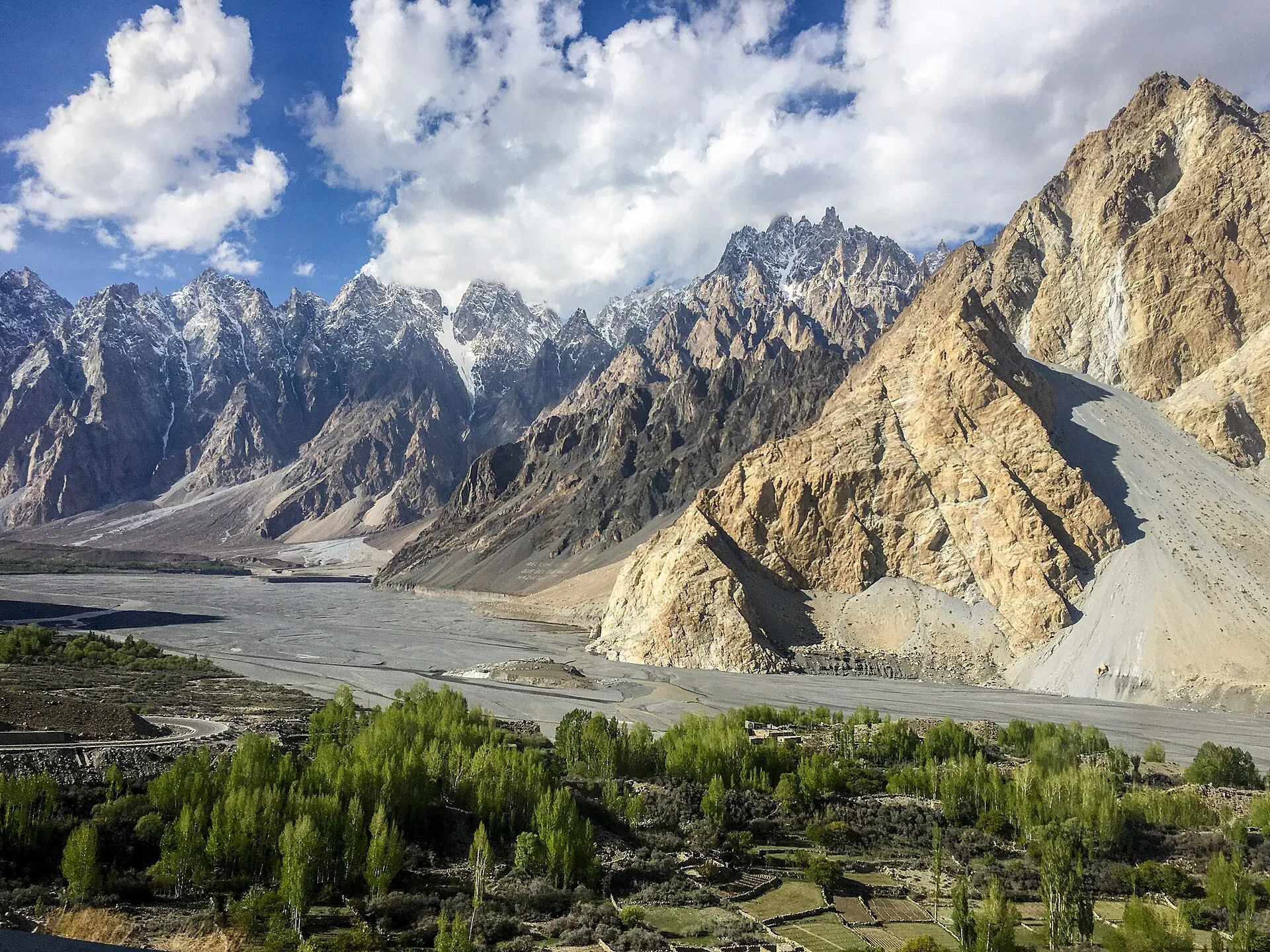
Photo: Mehrunisa Reimoo, with thanks · CC BY-SA 4.0 · via Wikimedia Commons · temporary stand-in photo

Passu Cones Viewpoint
A roadside viewpoint on the Karakoram Highway at Passu in Gojal, facing the jagged Passu Cones (Tupopdan, 6,106 m) above the Hunza River. Easy to reach by car.
Overview
The Passu Cones are a ridge of sharp, tooth-like peaks above Passu village in Gojal, upper Hunza. The highest, Tupopdan, is 6,106 m (Wikipedia). It is sometimes called Passu Cathedral and is described as the most photographed peak of the region. The viewpoint is a pull-off beside the Karakoram Highway (KKH), so you need no walk to see it. See Tupopdan.
Plan your visit
- Nearest town
- Passu
- Getting there
On the Karakoram Highway (N-35) in Gojal. From Karimabad about 53 km (OSRM 48 minutes, optimistic). The Hunza tourist sheet gives Passu as 50 km from Aliabad, 1 h 10 by car or jeep. More
Best months
May – Oct
- Passu Cones Viewpoint
- Related places nearby: Passu, Passu Glacier, Passu Sar, Batura Sar, Hunza Valley, Tupopdan (Passu Cones)
What to see and do
Look up at the Cones, then follow the valley floor. The Hunza River braids across a wide gravel bed. The Passu Glacier comes down close to the village, and the Batura Glacier lies just north. At 56 km, Batura is described as the seventh-longest non-polar glacier in the world and reaches close to the highway. Passu Sar (7,478 m), Shispare and Batura Sar are among the higher summits in the area. There is no official list of which peaks show from each pull-off, so ask your host to name them.
The village and its people
Passu is about 20 km from Gulmit and about 147 km up the river from Gilgit. The village is mainly Wakhi. Wikipedia says their ancestors came from the Wakhan between 1870 and 1948. They speak Wakhi and are Ismaili. Borith Lake, a saline lake at about 2,600 m, lies below Hussaini village; see Borith Lake and the Hussaini suspension bridge. See also Passu Glacier.
When to visit
Most people stop in daylight between May and October, when the KKH is busy and the weather is steadier. For photographs, early morning and late afternoon give softer light than midday (general advice). Haze and cloud often hide the tops by afternoon. In winter the road is open at times, but check conditions before travelling.
Where to stay and eat
Passu village has guesthouses, and simple roadside food stops are common along the highway. Ask at Karimabad or Gulmit for current options.
Good to know
- Getting there: The viewpoint is about 53 km from Karimabad (OSRM, 48 minutes, optimistic). The Hunza tourist sheet gives Passu as 50 km from Aliabad, about 1 h 10 by car or jeep.
- Altitude: Passu village is at about 2,500 m. The exact height of the pull-off is not confirmed.
- Safety: Cars and trucks use this highway at speed. Park fully off the carriageway and watch for traffic when crossing to photograph. Rockfall and landslides can close the road after rain.
- For foreign visitors: the UK FCDO does not advise against Gilgit-Baltistan generally (updated 27 October 2026). Check the live page for changes before travelling.
Highlights
- Roadside view of the Passu Cones (Tupopdan, 6,106 m)
- No walking needed
- Hunza River bed and glaciers in the same frame
- On the KKH between Gulmit and Sost
Getting there
On the Karakoram Highway (N-35) in Gojal. From Karimabad about 53 km (OSRM 48 minutes, optimistic). The Hunza tourist sheet gives Passu as 50 km from Aliabad, 1 h 10 by car or jeep. Shared vans run Gilgit to Sost along the highway.
Tips
- Park fully off the road and watch for fast traffic.
- Photograph in the early morning or late afternoon for softer light.
- Combine the stop with the Passu Glacier and the Hussaini suspension bridge.
- Carry a layer; the wind off the glacier is cold.
Facilities
- Roadside pull-off
- Guesthouses and food in Passu village
Photos we still need: the Hunza River gravel bed and Passu Glacier seen from the highway; the village of Passu below the Cones. Send us yours
Sources and last checked
Last checked Confidence medium5 sources3 still to check
- Last checked
- Method
- Desk research from published sources
- Confidence
- medium
- Checked by
- trek.pk research team
Researched from published sources; not yet checked on the ground by our team. Spot something out of date? Report a mistake.
Sources
- Passu Cones (Wikipedia) · Wikipedia · checked
- District Hunza tourist guide and map · Government of Pakistan tourism portal · checked
- Passu Cones Viewpoint (OpenStreetMap place) · OpenStreetMap contributors · checked
- OSRM driving route service: distances and times measured 16 November 2026 (times are optimistic, without stops) · OpenStreetMap / OSRM · checked
- Pakistan travel advice: warnings and insurance (updated 27 October 2026) · UK Foreign, Commonwealth & Development Office · checked
Still to be checked on the ground (3)
- Elevation of the pull-off (OpenStreetMap has a 'Passu Cones Viewpoint' point on the KKH, used for the map; no height published)
- Which peaks are named from this pull-off
- Winter road conditions
Nearby and related

Passu
A Wakhi village in Gojal beside the Passu Glacier, below the jagged Passu Cones (Tupopdan, 6,106 m). Known for Hussaini Suspension Bridge, glacier walks and Batura views.

Passu Glacier
A glacier south of Passu village in Gojal that you can see from the KKH and reach on a short walk. It lies below Passu Sar and has been retreating, so its length depends on the source.
Passu Sar
Passu Sar (7,478 m) is the high point of the Passu massif in the Batura Muztagh, above Passu village and the Passu Glacier in Gojal. The date of its first ascent is disputed.

Batura Sar
Batura Sar (7,795 m), also called Batura I, is the highest peak of the Batura Muztagh above Passu in Upper Hunza. It is the 25th-highest mountain on Earth and set well back from the Hunza Valley behind the Batura Wall.

Hunza River
The river that runs beside the Karakoram Highway through Gojal, Hunza and Nagar before joining the Gilgit River. It formed Attabad Lake in 2010, when a landslide blocked it.

Hunza Valley
A long Karakoram valley on the Karakoram Highway, with Karimabad, Baltit and Altit forts, Ganish village and Attabad Lake, below Rakaposhi and Ultar Sar. About 100 km from Gilgit.
Tupopdan (Passu Cones)
Tupopdan (6,106 m) is the highest summit of the Passu Cones, the jagged peaks above Passu village. It is also called Passu Cathedral. It is seen from the Karakoram Highway and on the Avdegar and Patundas walks.

Hunza and Khunjerab (KKH)
A 7-8 day road trip from Islamabad up the Karakoram Highway to Hunza and on to Khunjerab Pass (4,693 m), with overnight stops at Besham, Chilas and Gilgit.