

Photo: Usman.pg, with thanks · CC BY-SA 3.0 · via Wikimedia Commons · temporary stand-in photo

Rohtas Fort
A huge 16th-century fort of Sher Shah Suri near Jhelum, with four kilometres of walls, monumental gates and a village still living inside. UNESCO inscribed it in 1997.
Overview
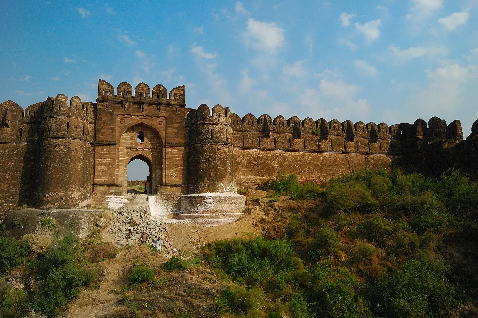
Rohtas Fort stands on a hill in the Tilla Jogian range about 16 km north-west of Jhelum, near the town of Dina. Sher Shah Suri ordered it built in 1541 to control the Gakhar tribes and to block the exiled Mughal Humayun from returning. It is plain, strong and very large, and it is among the best-preserved military forts in South Asia. UNESCO inscribed it in 1997, citing it as a model of 16th-century Muslim military architecture that blends Turkish and South Asian traditions.
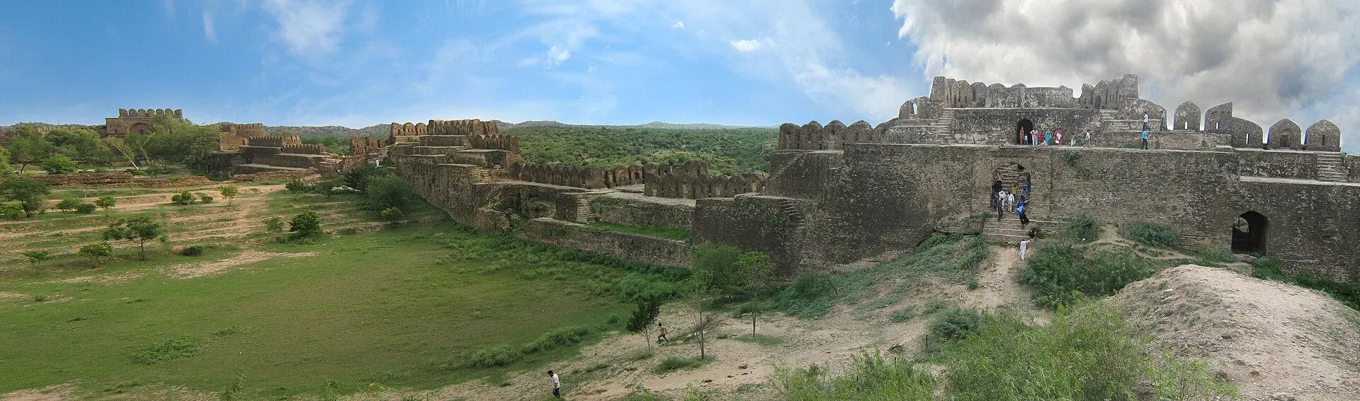
Photo: Skazimr (talk), with thanks · CC BY-SA 3.0 · via Wikimedia Commons · temporary stand-in photo

The walls run for about 4 km, roughly 10 to 18 metres high and 10 to 13 metres thick, in sandstone and lime mortar. They follow the hill in an irregular triangle, enclose about 70 hectares at 819 metres above sea level, and carry 68 bastions. Parts of the fort are still lived in: a village occupies over a third of the area.
Plan your visit
- Nearest town
- Dina
- Opening hours
- No official opening hours found. Check with the Punjab Department of Archaeology.
- Getting there
From Jhelum it is about 24 km by road (roughly 28 minutes, OSRM) via Dina. More
Best months
Oct – Mar
- Rohtas Fort
- Related places nearby: Nandana Fort, Dina, Tilla Jogian (Jogi monastery and hill), Jhelum
History
Sher Shah Suri began the fort in 1541. His finance minister Todar Mal supervised the work. The Gakhars refused to work at first, until wages were raised. Sher Shah died in 1545 before it was finished. Humayun regained the fort in 1555. The Mughals used it little, because it had no gardens and was built for war, although Akbar stayed a night and Jahangir rested and held court briefly. Akbar built Attock Fort nearby in the 1580s. Charat Singh captured Rohtas in 1767 and gave it to Gakhar chiefs. The Sikhs used it for administration from 1799, and the British took over in 1849.
The gates
Wikipedia gives twelve gates in one section and fourteen in another, counting small entrances, so the exact number varies by source. The main ones, in grey stone, are:
- Sohail Gate. The grand gate, about 21 m high, with some of the finest masonry in the fort and a saint's tomb built into it. A museum on Sher Shah Suri is on its upper floor.
- Kabuli Gate. Faces north-west towards Kabul. It now holds a visitor information centre and museum run by the Himalayan Wildlife Foundation.
- Shishi Gate. Named for blue glazed tiles on its outer arch, said to be among the earliest examples of the technique. A Persian inscription dates it to 1541.
- Langar Khani Gate. Built as a trap in the line of fire from the bastions: the passage is L-shaped, so attackers had to turn right after entering.
- Talaqi and Gatali gates. Gatali faces the ford over the Jhelum that was the crossing for the Kashmir valley.
- Khwas Khani Gate. The original main entrance from the Grand Trunk Road.
What to see and do
- The ramparts. Walk along walls with stepped terraces, battlements and machicolations (openings for dropping missiles on attackers) decorated with geometric patterns.
- Shahi Masjid. A small mosque near Kabuli Gate and the most decorated original building. Its prayer chamber is about 19 m long, with three domed sections and carved stone, including sunflower motifs and "Allah" in calligraphy. Its outer wall doubles as the fortification, so soldiers could walk across its roof. It has no ablution area.
- Haveli Man Singh. On the citadel's highest point, described as the fort's only palace.
- Rani Mahal. Once four rooms, now one small, richly carved room with a flower-like stone dome.
- Stepwells (baolis). The central stepwell is cut into limestone and has 148 steps. The royal stepwell near Kabuli Gate has 60 steps and small bathing chambers. A smaller one stands by Sar Gate.
- Rohtas village. A living village within the walls.
- Gurdwara Chowa Sahib. A Sikh shrine just outside the northern edge, near the Talaqi gate.
Allow half a day. The ground is rough and hilly, so wear sturdy shoes.
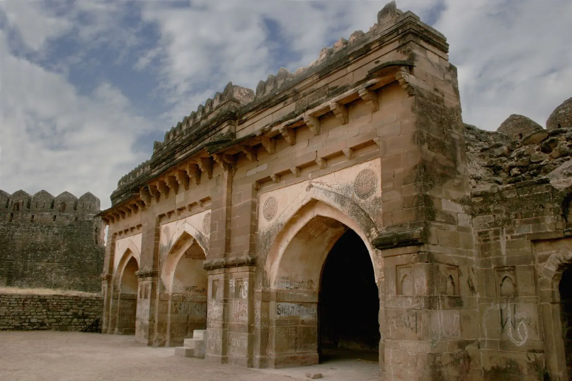
Photo: Yameen152, with thanks · CC BY-SA 4.0 · via Wikimedia Commons · temporary stand-in photo

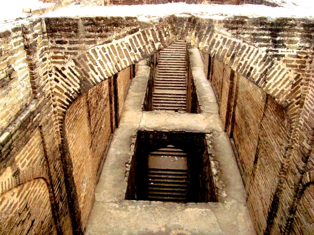
Photo: Hira Naeem, with thanks · CC BY-SA 3.0 · via Wikimedia Commons · temporary stand-in photo

Rohtas village
Wikipedia estimates about 4,000 residents in 450 houses (2016), with a bazaar, a post office, several schools and many mosques. A 1992 order to relocate residents was never enforced. People live and farm within the walls, so be respectful, ask before photographing residents and do not climb on unstable masonry.
When to visit
October to March is best. Summer afternoons are very hot on the exposed stone.
Where to stay and eat
There are few places to stay near the fort. Jhelum and Dina have hotels; most visitors come on a day trip from Islamabad, Rawalpindi or Lahore. Bring water and snacks.
Good to know
- Hours and fees. We have not confirmed official hours or ticket prices. Check with the Punjab Department of Archaeology before you go.
- Conservation. Part of the inner face of Talaqi Gate collapsed in 2005 after seepage and rain, and the right bastion of Gatali Gate has partly collapsed. The Himalayan Wildlife Foundation has run a conservation programme since 2000, with Norwegian support, and has restored Shah Chandwali Gate and conserved Haveli Man Singh and the Talaqi and Gatali gates. Seepage and foundation erosion remain concerns. There is no known current closure notice.
- Safety. The fort is not within the UK FCDO's listed areas (page updated 27 October 2026); re-check before travelling.
- Nearby. Attock Fort on the Indus is another Mughal-era fort in northern Punjab.
Highlights
- UNESCO World Heritage Site since 1997
- Walls about 4 km long on a 819-metre hill
- Sohail Gate and other monumental gates
- A living village inside the fort
- Built from 1541 for Sher Shah Suri
Getting there
From Jhelum it is about 24 km by road (roughly 28 minutes, OSRM) via Dina. From Islamabad it is about 112 km (about 1.5 hours) and from Lahore about 197 km (about 2 hours 45 minutes), mostly by the Grand Trunk Road and the motorway. Dina is about 11 km from the fort (OSRM, 17 November 2026, about 13 minutes). A taxi or private car from Jhelum or Dina is the practical way to reach the gate; ask locally about shared transport.
Tips
- Wear sturdy shoes; paths are uneven.
- Bring water: facilities are basic.
- Start early and use the winter months.
- Check hours with the Punjab archaeology department.
Photos we still need: Sohail Gate, Langar Khani Gate and the ramparts (candidate files have unclear authorship). Send us yours
Sources and last checked
Last checked Confidence medium5 sources4 still to check
- Last checked
- Method
- Desk research from published sources
- Confidence
- medium
- Checked by
- trek.pk research team
Researched from published sources; not yet checked on the ground by our team. Spot something out of date? Report a mistake.
Sources
- Rohtas Fort (Wikipedia) · Wikipedia · checked
- List of World Heritage Sites in Pakistan · Wikipedia · checked
- Pakistan Tourism Guide 2021 · Tourism Development Corporation of Pakistan (TDAP) · checked
- Pakistan travel advice: warnings and insurance (updated 27 October 2026) · UK Foreign, Commonwealth & Development Office · checked
- Dina, Pakistan · Wikipedia · checked
Still to be checked on the ground (4)
- Opening hours and fees (none found from an official source; UNESCO page returned 403)
- Number of gates: Wikipedia says twelve in one section and fourteen in another (two of the fourteen are 'entrances')
- Whether any gate or section is closed for conservation today (Wikipedia gives 2005 collapses only)
- Current state of the buildings inside (from Wikipedia; confirm on site)
Nearby and related

Attock Fort
A Mughal fort on the Indus at Attock, built by Akbar in 1581-83 with six gates and eight bastions. It is run by the army and is not open to the public.

Islamabad
Pakistan's green, planned capital at the foot of the Margalla Hills: Faisal Mosque, hillside trails, cafes and the gateway to the north.

Rawalpindi
Islamabad's older twin city: a busy bazaar and cantonment, the north's main rail and bus hub, and an easy base for Taxila and Murree.

Lahore
Punjab's capital and Pakistan's cultural city: Mughal forts, mosques and gardens, a lively Walled City, and some of the best food in the country.

Punjab
Pakistan's most populous province: Mughal Lahore, ancient Taxila and Harappa, Sufi shrines, the Salt Range, the Cholistan desert and the hills of Murree.
Nandana Fort
A ruined hilltop fort and temple on the eastern Salt Range near Baghanwala in Jhelum district, once a capital of the Odi Shahi dynasty.
Dina
Army-linked town on the Grand Trunk Road in Jhelum District, at the junctions for Rohtas Fort and Mangla Dam.

Tilla Jogian (Jogi monastery and hill), Jhelum
The highest hill of the eastern Salt Range (about 975 m), crowned by an abandoned Hindu temple and Kanphata jogi monastery complex about 25 km west of Jhelum.