

Photo: Ravi Baghel, Marcus Nüsser, with thanks · CC BY 4.0 · via Wikimedia Commons · temporary stand-in photo

Siachen Glacier
One of the longest glaciers outside the polar regions, about 70 to 76 km, in the eastern Karakoram. It is a restricted military area and not a visitor destination; this page is for information only.
Overview
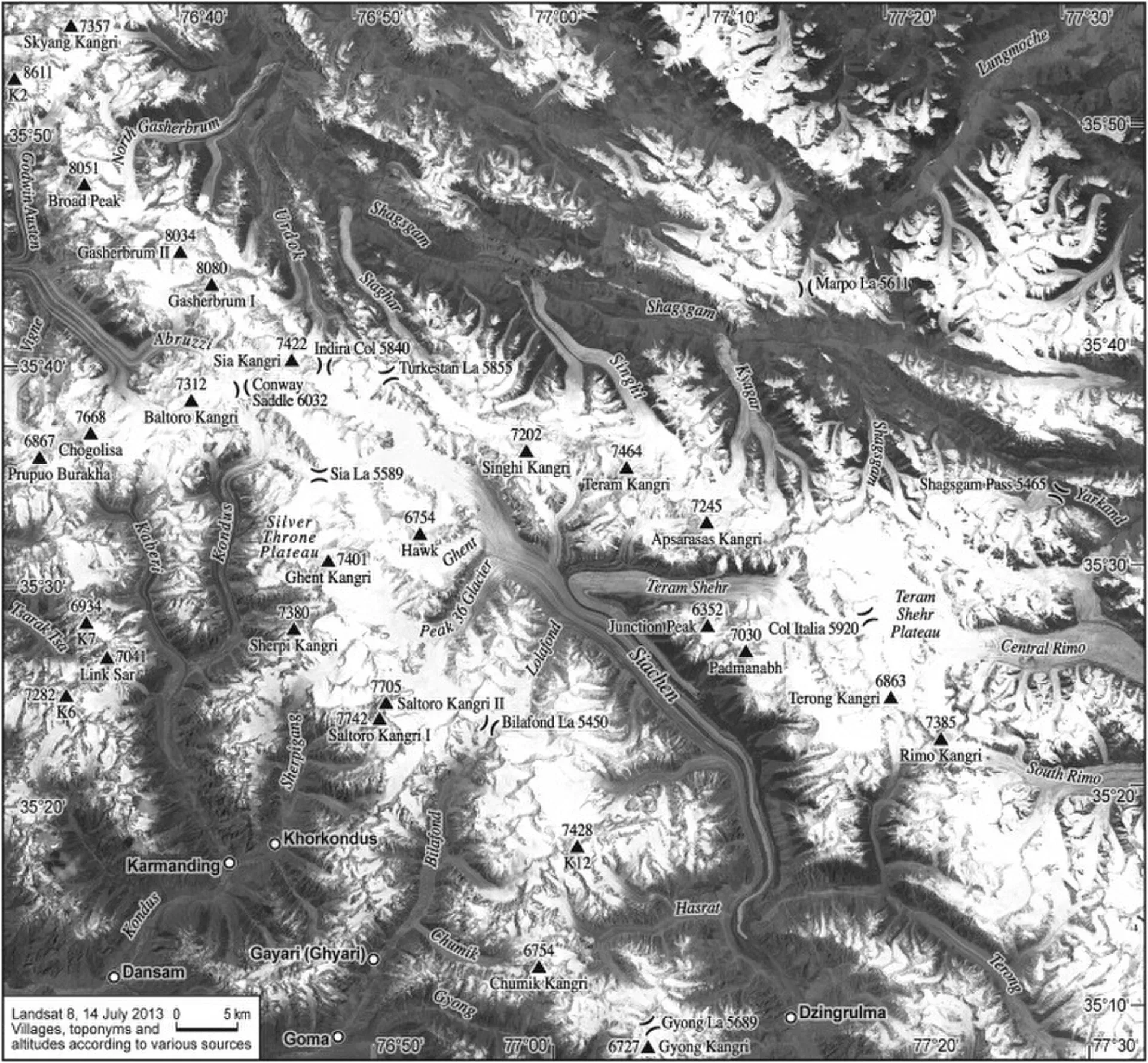
The Siachen Glacier is in the eastern Karakoram, in an area that India and Pakistan both claim. It is the longest glacier in the Karakoram and one of the longest outside the polar regions. Published lengths vary from about 70 km to 76 km: 76 km by the longest route, and 70 km measured from Indira Col. A peer-reviewed assessment gives about 74 km, with a width of 1 to 8 km. The glacier system, including its tributary glaciers, covers about 700 sq km.
The glacier falls from about 5,753 m at its head at Indira Col, on the border with China, to about 3,620 m at its snout.
Plan your visit
- Getting there
Not applicable. Ordinary visitors cannot go to the Siachen Glacier. More
- Siachen Glacier
- Related place nearby: Chumik Glacier
Geography
The glacier lies between the Saltoro Ridge to the west and the main Karakoram range to the east, just south of the major drainage divide. The Saltoro Ridge runs north from Sia Kangri, and its crest ranges from about 5,450 to 7,720 m. The main passes along it, from north to south, are Sia La (5,589 m), Bilafond La (5,450 m) and Gyong La (5,689 m).
Meltwater from the glacier feeds the Nubra River, which flows into the Shyok and then the Indus. Average winter snowfall exceeds 1,000 cm, and temperatures can fall to about -50 degrees C.
The dispute and the military presence
The 1949 Karachi Agreement fixed the ceasefire line only as far as a point called NJ9842, and left the line northwards vague. India and Pakistan read it differently. In 1984 India launched Operation Meghdoot and took control of the glacier and its tributaries; Indian troops occupied most of the Saltoro Ridge heights a day ahead of Pakistan's own plan, Operation Ababeel. Fighting continued intermittently after April 1984.
Both countries keep permanent posts above 6,000 m, and neither had forces there before 1984. Far more soldiers have died from weather and altitude than from combat. In April 2012 an avalanche in the Gayari sector killed 140 Pakistani personnel. Proposals for a "peace park" in the area have been made at international conservation meetings.
Troop camps have left waste on the ice, and mountaineers have reported discarded shells, parachutes and other debris.
Can you visit?
No. The glacier is a restricted military area and is not open to ordinary visitors from Pakistan. This is an information page only, and there is no trek, viewpoint or permit that this site can recommend.
Ask the district administration or local police about current conditions before you go. For foreign visitors: the UK FCDO advises against all travel within 10 miles of the Line of Control, which covers the approaches to this area. For big Karakoram glaciers on open or permit-based routes, see Baltoro Glacier, Biafo Glacier and Hispar Glacier.
Climate and melting
Measurements disagree, which is common for glaciers measured by different teams over different years. A Pakistan Meteorological Department study by Dr Ghulam Rasul, reported by Dawn on 4 January 2013 and made under an EU-funded WWF-Pakistan project, estimated that the glacier retreated by about 5.9 km between 1989 and 2009 and thinned by 17 per cent, and suggested that military presence might also affect nearby glaciers. A 2017 study in the Journal of Glaciology found that the total glacier area did not change significantly between 1980 and 2014, although the exposed-ice area decreased, and that the mass budget for 1999-2007 was close to balance. The studies measure different things in different years.
Good to know
- Access. Restricted. Do not try to approach the glacier.
- Travel advice. For foreign visitors: the UK FCDO page for Pakistan (updated 27 October 2026, checked 16 November 2026) does not advise against Gilgit-Baltistan as a whole. It does advise against all travel on the Karakoram Highway (KKH) between Mansehra and Chilas, the usual road route from Islamabad, so check the live page before you plan and consider flying to Gilgit or Skardu (weather permitting). The FCDO page also advises against all travel within 10 miles of the Line of Control.
Highlights
- About 70 to 76 km long, by source
- Restricted military area; no visitor access
- Measurements of retreat and mass change disagree
- Information only
Getting there
Not applicable. Ordinary visitors cannot go to the Siachen Glacier.
Tips
- Do not try to approach the glacier.
- Visit the Baltoro, Biafo or Hispar glacier routes instead, with permits.
- Check the FCDO page for the Line of Control zone.
Photos we still need: a ground-level or aerial photograph of the glacier. Send us yours
Sources and last checked
Last checked Confidence medium5 sources2 still to check
- Last checked
- Method
- Desk research from published sources
- Confidence
- medium
- Checked by
- trek.pk research team
Researched from published sources; not yet checked on the ground by our team. Spot something out of date? Report a mistake.
Sources
- Siachen Glacier · Wikipedia · checked
- Area and mass changes of Siachen Glacier (East Karakoram) · Journal of Glaciology (2017) · checked
- Siachen Glacier shrinking, says study · Dawn · checked
- Pakistan travel advice · UK Foreign, Commonwealth & Development Office · checked
- Glacial Lake Outburst Flood GLOF-II · Ministry of Climate Change and Environmental Coordination, Pakistan · checked
Still to be checked on the ground (2)
- Exact length (70 km from Indira Col, 76 km by the longest route; one study gives about 74 km)
- Current access rules (none for the public; no official page opened)
Nearby and related

Gilgit-Baltistan
Pakistan's far north: three great ranges meet here, with K2, Nanga Parbat, giant glaciers, the Karakoram Highway and the valleys of Hunza, Skardu and Gilgit.

Central Karakoram National Park
Pakistan's largest protected area, covering about 10,500 square kilometres of the highest mountains on earth: K2, Gasherbrum I and II, Broad Peak and the Baltoro, Biafo and Hispar glaciers.
Chumik Glacier
A glacier west of the Saltoro ridge, in the Siachen conflict zone. It is a military area, not a trekking destination.