

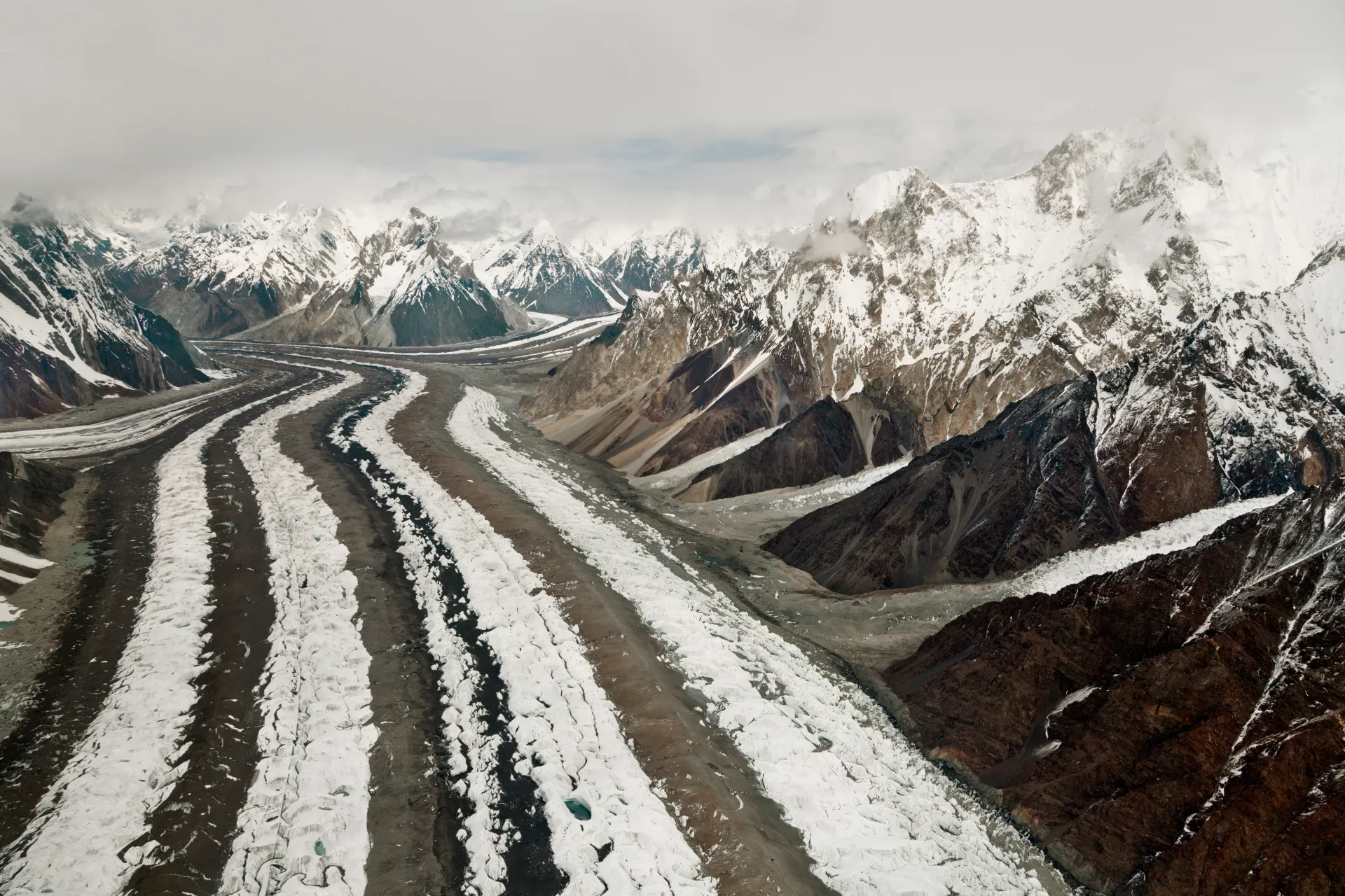
Photo: Thsulemani, with thanks · CC BY-SA 3.0 · via Wikimedia Commons · temporary stand-in photo

Baltoro Glacier
About 62 km long, the Baltoro is the glacier you walk up to reach K2 Base Camp and Concordia. A restricted-zone trek of about two weeks from Askole, inside Central Karakoram National Park.
Overview
The Baltoro Glacier fills the heart of the Karakoram in Shigar District, Gilgit-Baltistan. Most sources give its length as about 62 km. The Central Karakoram National Park (CKNP) says 62 km; a 2006 glaciology paper by Mayer and colleagues says "more than 60 km" and a drainage basin of about 1,500 km²; other sources give 58 to 64 km. Where you measure from changes the number, and glaciers move, so treat every figure as approximate. Of the glacier's length, the upper third is clean ice and the lower two-thirds are buried under rock debris.
At Concordia, about 4,600 m up, the Baltoro meets the Godwin-Austen Glacier. Around it stand K2 (8,611 m), Broad Peak (8,047 m), Gasherbrum I, II, III and IV, Chogolisa, Masherbrum, Mitre Peak and the Trango and Muztagh towers.
Plan your visit
- Nearest town
- Askole
- Getting there
Fly or drive to Skardu, then take a jeep road through Shigar to Askole, the last village and the start of the walk. Ask your operator for the current drive time. More
Best months
Jun – Sep
- Baltoro Glacier
- Related places nearby: Central Karakoram National Park, Shigar Valley, Khaplu and Hushe, Muztagh Tower, Chogolisa, Uli Biaho Tower, Paiju Peak, Angel Sar, Godwin-Austen Glacier (K2 Base Camp), Vigne Glacier (Concordia to Gondogoro La), Biarchedi Glacier, Hainablak Glacier
The glacier and its peaks
The name comes from Balti and, according to Wikipedia, means "bone breaker". The ice fills a wide trough with steep sidewalls scored by moving ice. Small valley glaciers meet the main glacier in icefalls, and meltwater lakes sit in hollows on the surface.
Wikipedia gives these heights for the peaks around it: K2 8,611 m, Broad Peak 8,047 m, Gasherbrum I 8,080 m, II 8,035 m, III 7,946 m and IV 7,932 m, Masherbrum 7,821 m, Chogolisa 7,665 m, Muztagh Tower 7,273 m, Uli Biaho Tower 6,417 m, the Trango Towers 6,286 m and Mitre Peak 6,010 m. The Masherbrum range lies south of the glacier and the Baltoro Muztagh north and east of it. Wikipedia describes the Trango Towers as having the tallest vertical cliffs in the world.
What to see and do
You cannot see the Baltoro from a road. The only way is the trek from Askole (see the Baltoro Glacier trek page), about 72 km on foot up the glacier to Concordia, then on to K2 Base Camp. Expect about 14 to 21 days there and back. The CKNP notes that crampons and rope are not needed to reach Concordia, but sturdy ankle-supporting boots and trekking poles are. Beyond Concordia, routes such as the Gondogoro La need crampons and rope.
Read our page on glacier travel basics before you go. Stay on the established route, do not camp under icefalls, and expect a lot of moving rubble and meltwater.
When to visit
The usual trekking season is June to September, with the busiest weeks from mid-July to August. Early in the season the approach rivers are lower. Plan for snow and cold at Concordia even in summer.
Where to stay and eat
There are no lodges on the glacier. Trekkers camp at traditional sites with a licensed operator, cook and porters. In Skardu and Shigar you can stay in guesthouses before and after.
Good to know
- Permits. This is a restricted-zone trek. You need a permit arranged through a licensed Pakistani tour operator, a licensed guide, and CKNP fees. A trekking permit fee and other charges apply; current fees will be added soon, so ask your operator for the written fee list.
- Climate and hazards. Studies of the Baltoro between 2001 and 2011 recorded visible changes, especially near Concordia, and some research describes it as surging rather than steadily retreating. The EV-K2-CNR research station at Urdukas has monitored the glacier for years. Glaciers in the central and western Karakoram have behaved differently from most of the world's glaciers. Some studies report them holding steady or even gaining mass, which is called the "Karakoram anomaly"; eastern Karakoram glaciers have been retreating more clearly. Even so, rising temperatures bring hazards. Pakistan's climate ministry and UNDP report 3,044 glacial lakes in Gilgit-Baltistan and Khyber Pakhtunkhwa, of which 33 were assessed as prone to dangerous outburst floods (GLOFs). The UNDP-run GLOF II project, funded by the Green Climate Fund, covers 24 valleys with early-warning systems.
- Rescue. Help is days away. Take insurance that covers helicopter rescue.
- Travel advice. For foreign visitors: the UK FCDO page for Pakistan (updated 27 October 2026, checked 16 November 2026) does not advise against Gilgit-Baltistan as a whole. It does advise against all travel on the Karakoram Highway (KKH) between Mansehra and Chilas, the usual road route from Islamabad, so check the live page before you plan and consider flying to Gilgit or Skardu (weather permitting).
Highlights
- About 62 km long (sources: 58 to 64 km)
- Concordia, where the Baltoro and Godwin-Austen glaciers meet, at about 4,600 m
- Views of K2, Broad Peak, the Gasherbrums and the Trango Towers
- Restricted zone: permit, licensed guide and CKNP fees
Getting there
Fly or drive to Skardu, then take a jeep road through Shigar to Askole, the last village and the start of the walk. Ask your operator for the current drive time. See The UK FCDO page for Pakistan (updated 27 October 2026, checked 16 November 2026) does not advise against Gilgit-Baltistan as a whole. It does advise against all travel on the Karakoram Highway (KKH) between Mansehra and Chilas, the usual road route from Islamabad, so check the live page before you plan and consider flying to Gilgit or Skardu (weather permitting).
Tips
- Book through a licensed Pakistani operator and ask for the current fee list in writing.
- Bring poles and ankle-supporting boots for the loose rubble on the lower glacier.
- Do not camp under icefalls or rock walls.
- Read the glacier travel basics before you go.
Sources and last checked
Last checked Confidence medium8 sources2 still to check
- Last checked
- Method
- Desk research from published sources
- Confidence
- medium
- Checked by
- trek.pk research team
Researched from published sources; not yet checked on the ground by our team. Spot something out of date? Report a mistake.
Sources
- Karakoram glaciers: Baltoro, Biafo, Hispar · Central Karakoram National Park (cknp.org) · checked
- Baltoro Glacier · Wikipedia · checked
- Glaciological characteristics of the ablation zone of Baltoro Glacier, Karakoram, Pakistan (Mayer et al., 2006) · Annals of Glaciology · checked
- Baltoro Glacier (old trek.pk page, text from Lonely Planet Trekking in the Karakoram and Hindukush, c. 2002; facts only) · trek.pk / Lonely Planet · checked
- Glacier-Related Hazards Along the International Karakoram Highway: Status and Future Perspectives · Frontiers in Earth Science (2021) · checked
- Glacial Lake Outburst Flood GLOF-II · Ministry of Climate Change and Environmental Coordination, Pakistan · checked
- Scaling-up of GLOF risk reduction in Northern Pakistan (GLOF II) · UNDP Pakistan · checked
- Pakistan travel advice · UK Foreign, Commonwealth & Development Office · checked
Still to be checked on the ground (2)
- Current permit rules and fee list
- Concordia altitude (Wikipedia, citing Mayer et al. 2006, gives 4,600 m; some sources say up to 4,650 m)
Nearby and related

Baltoro Glacier and K2 Base Camp

Gondogoro La
Gondogoro Valley

Masherbrum Base Camp

Central Karakoram National Park
Pakistan's largest protected area, covering about 10,500 square kilometres of the highest mountains on earth: K2, Gasherbrum I and II, Broad Peak and the Baltoro, Biafo and Hispar glaciers.

Shigar Valley
A green valley north-east of Skardu with Shigar Fort, old wooden mosques and orchards, leading to Askole and the trailheads for the Baltoro, Biafo and Hispar treks.

Skardu
The main town of Baltistan, where the Indus meets the Shigar river. Skardu is the base for the Deosai Plains, the Kachura and Satpara lakes, Shigar, and the K2 and Baltoro treks.

Khaplu and Hushe
Khaplu, the old Yabgo capital on the Shyok River with its restored palace and mosque, and the Hushe valley beyond, the road end for Masherbrum, K6, K7 and the Gondogoro La.
Muztagh Tower
Muztagh Tower (7,276 m) is a rock tower in the Baltoro Muztagh, first climbed in 1956 by a British team. It rises above the Baltoro Glacier route to K2.
Chogolisa
Chogolisa (7,665 m) is a double-summit peak near Concordia on the Baltoro Glacier. Hermann Buhl died on it in 1957, and it was first climbed in 1975.
Uli Biaho Tower
Uli Biaho Tower (about 6,100 m) is a granite tower near the Trango Towers above the Baltoro Glacier. An American team climbed its east face in 1979.
Paiju Peak
Paiju Peak (6,610 m) is a granite peak near the end of the Baltoro Glacier. It was first climbed in 1976 by an Alpine Club of Pakistan team.
Angel Sar
Angel Sar (6,802 m) is a peak in the Baltoro Muztagh, Shigar district, first climbed in 1983. It is listed inside Central Karakoram National Park.
Godwin-Austen Glacier (K2 Base Camp)
The glacier below K2. It meets the Baltoro Glacier at Concordia, and the trek to K2 Base Camp follows its medial moraine.
Vigne Glacier (Concordia to Gondogoro La)
A glacier of about 10 km south of Concordia that gives access to the Gondogoro La. Trekkers climb it in roped teams to Ali Camp.

Biarchedi Glacier
A Karakoram glacier north-east of Biarchedi Peak that flows north into the Baltoro Glacier. Few details are known.
Hainablak Glacier
A glacier in the Baltoro Muztagh near Trango Tower. Sources are thin.
Braldu River
A glacier-fed river in Shigar District that rises at the Baltoro and Biafo glaciers. It forms the road and trail approach to the Baltoro and K2, and ends at Tingstun where it joins the Basha Basna to form the Shigar River.