

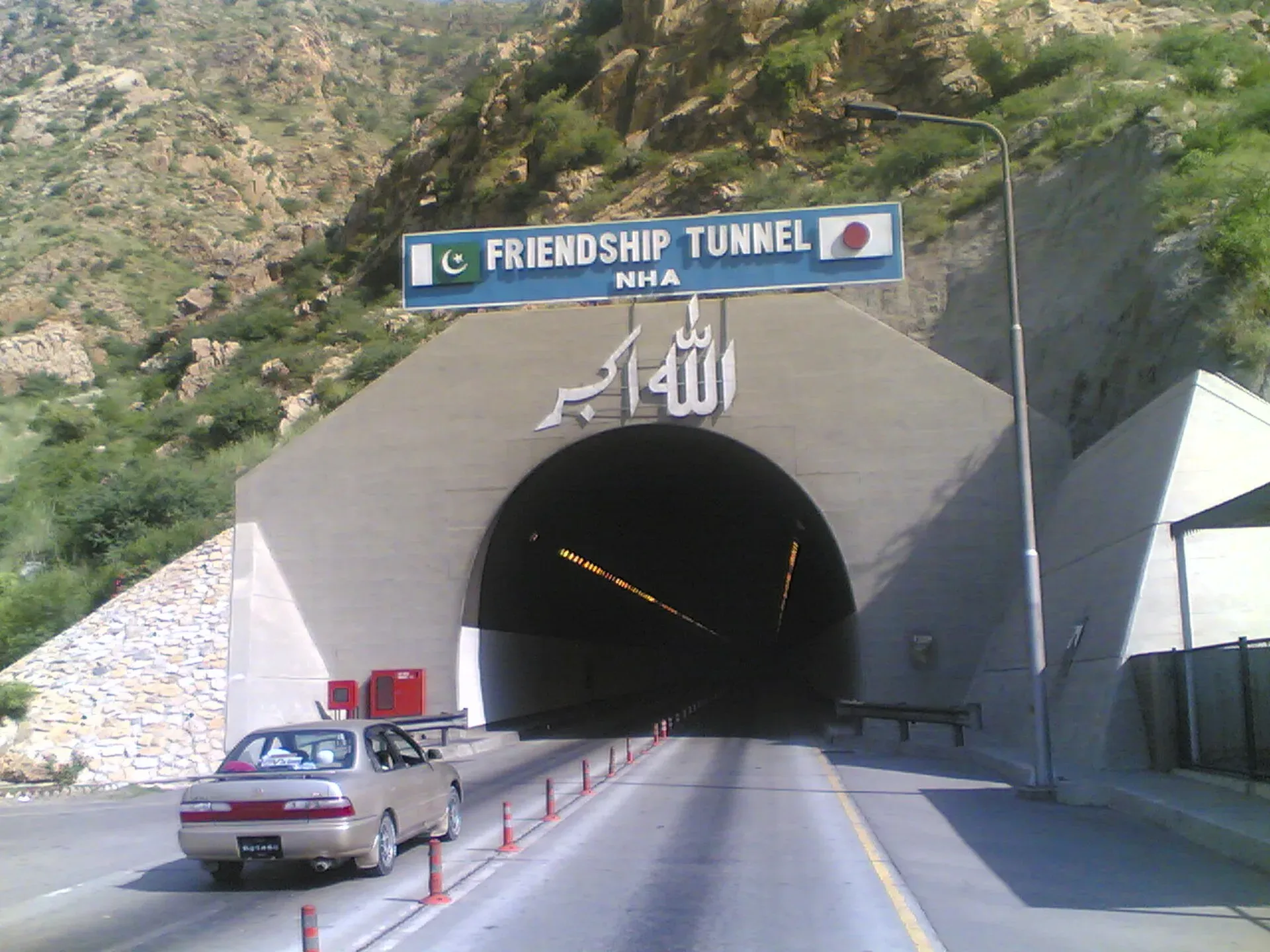
Photo: Manzoor Ahmad, with thanks · CC BY 3.0 · via Wikimedia Commons · temporary stand-in photo

N-55 Indus Highway: Kotri-Peshawar
The 1,264 km Indus Highway links Kotri in Sindh to Peshawar through Dera Ghazi Khan, Dera Ismail Khan and Kohat Tunnel. It is a quieter alternative to the N-5, but much of it lies in areas the UK advises against.
Overview
The N-55 follows the Indus River for 1,264 km (NHA list) from Kotri, near Hyderabad, to Peshawar. It was proposed in 1980 as a shorter alternative to the crowded N-5 and to help western Sindh and eastern Khyber Pakhtunkhwa; building began at Kotri in 1981 and finished at Peshawar in 1997 (Wikipedia). It is two to four lanes wide. Road routing from Kotri to Peshawar measures about 1,268 km.
Few visitors drive the whole road. Most use short sections for a specific destination: Larkana for Moenjodaro, Dera Ghazi Khan for Fort Munro, or Kohat.
Route and stops
Towns on the road, from south to north, include Jamshoro, Sehwan (Dawn names the Jamshoro-Sehwan stretch of the N-55; Wikipedia's town list omits it), Dadu, Larkana, Shikarpur, Kandhkot, Kashmore, Rajanpur, Dera Ghazi Khan, Taunsa Sharif, Dera Ismail Khan, Lakki Marwat, Karak, Kohat and Darra Adam Khel (Wikipedia). It passes through the Kohat Tunnel before Peshawar.
Measured distances from Kotri by road: Dadu about 196 km, Larkana 321, Shikarpur 399, Kashmore 510, Rajanpur 623, Dera Ghazi Khan 737, Taunsa 815, Dera Ismail Khan 948, Lakki Marwat 1,056, Karak 1,126, Kohat 1,201 and Peshawar 1,268.
Towns and stops in order
Dera Ghazi Khan. The city is the base for Fort Munro, a hill station on the Punjab-Balochistan border in the Sulaiman range, about 85 km west. Wikipedia says Sir Robert Sandeman founded it in 1866 as a summer retreat and that it was named after Colonel Andrew Munro; sources disagree on its height (1,970 m, 2,180 m and 1,800 m appear in one article). Wikivoyage also lists the shrine of Sakhi Sarwar at Muqam, about 35 km from the city, which draws large crowds each March, and the Rani, Sadar and Model bazaars. Saraiki and Balochi are widely spoken.
Dera Ismail Khan. The city stands on the west bank of the Indus. Floods destroyed the original town in 1823, and Nawab Sher Muhammad Khan of the Saddozai clan founded the present city in 1825, about 6 km from the river's main channel. The Gomal river joins the Indus here, and the city grew rich on trade through the Gomal Pass. Wikipedia gives a record high of 51 degrees C. Wikipedia names the Lal Mahra tombs, the ruins at Kafir Kot and the remnants of the old nine-gated wall as local landmarks.
Karak. The district headquarters stands at about 548 m. Wikipedia says it is the only district in Pakistan inhabited by one Pashtun tribe, the Khattaks, and puts it 123 km from Peshawar on the Indus Highway (the measured road distance above is longer, about 142 km, so allow for routing differences).
Kohat, the tunnel and Peshawar. Kohat is the last major town before the Kohat Tunnel and Peshawar. At Peshawar, Wikivoyage describes the most famous dish as chappal kabab (a flat beef kebab shaped like a sandal sole), with tikka and karahi (tomato and chilli stew) cooked at the Namak Mandi eating places and kawa (green tea) served sweet.
Kohat Tunnel
The Kohat Tunnel, also called the Pak-Japan Friendship Tunnel, opened in June 2003 after construction began in 1999. It is about 1.89 km long (headline figure) and saves roughly 20 minutes over the old Kohat Pass road. In early 2008 militants took control of the tunnel and security forces retook it on 27 January (Wikipedia). A toll applies at the tunnel. ProPakistani (10 July 2026) reports that the NHA revised its toll schedule from 10 July 2026 and lists the Kohat Tunnel, but the NHA notice itself is not cited here, so current rates will be added soon; check the official NHA notice.
Road condition and upgrades
Condition varies. The old two-lane sections are narrow and worn; trucks, buses and animals share them. Widening has been planned for years. A Wikipedia article gives a Rs 44.7 billion plan (March 2021 source) to add two lanes to the Shikarpur-Rajanpur section. A report dated 6 October 2026 on a prime-ministerial meeting named upgrades of the Sehwan-San and Ratodero-Shikarpur sections and an additional carriageway on another Sindh section (ProPakistani). Radio Pakistan (30 October 2026) gives the position by section: Shikarpur-Rajanpur additional carriageway (221.9 km) 62 per cent complete; Rajanpur-Dera Ghazi Khan (121.5 km) still awaiting letters of award because of land acquisition and resettlement; Dera Ghazi Khan-Dera Ismail Khan (208.19 km) awarded, with contractors mobilising and no progress figure. The Jamshoro-Sehwan dual carriageway (about 130 km, Rs14 billion, launched December 2017) was still unfinished in April 2024, when NHA promised June 2024 (Dawn, 19 April 2024); there is no known later report. Expect works, diversions and uneven surfaces.
What to see along it
- Moenjodaro and the Larkana area, by a short side road.
- Dadu and the Kirthar approaches.
- Dera Ghazi Khan, base for Fort Munro and the Sulaiman foothills.
- Taunsa Barrage and the wildlife sanctuary.
- Dera Ismail Khan on the Indus.
Hazards
- Floods: the road runs near the Indus. High floods, usually July to September, can overtop or wash out sections. There is no known dated 2026 flood report for this road.
- Heat: summer temperatures in Sindh and south Punjab are very high. Carry water.
- Security and driving: much of the road crosses remote country. Drive in daylight only.
Fuel and services
Fuel stations are regular in towns, with long gaps between them in upper Sindh and west of Dera Ghazi Khan. Fill up at every large town. Services for foreign visitors are limited.
Checkposts
Police and Levies checkposts are common, especially in Khyber Pakhtunkhwa. Carry passport and visa copies.
Safety and travel advice by section
Ask the district administration or local police about current conditions before you go. For foreign visitors: the UK FCDO page (updated 27 October 2026, checked 16 November 2026) advises against all but essential travel to Sindh north of and including Nawabshah, which covers the road from Dadu northwards, and to Dera Ghazi Khan. It advises against all travel to Dera Ismail Khan, Lakki Marwat, Karak, Kohat, Peshawar and the other KP districts it lists, and notes KP emergency measures. Only the southern section near Kotri is not named. Read the live text before planning any journey on this road.
Highlights
- Alternative to the N-5 along the Indus
- Passes Larkana, Dera Ghazi Khan and Dera Ismail Khan
- Kohat Tunnel, opened 2003
- Two-lane to four-lane road of 1,264 km
Stops
- DaduSindh; route to Moenjodaro area
- LarkanaNear Moenjodaro
- ShikarpurUpper Sindh
- KashmoreSindh-Punjab boundary area
- RajanpurSouth Punjab
- Dera Ghazi KhanGateway to Fort Munro
- TaunsaTaunsa Barrage on the Indus
- Dera Ismail KhanFirst big Khyber Pakhtunkhwa city
- Lakki MarwatKP
- KarakKP
- KohatKohat Tunnel nearby
- PeshawarMeets the N-5
km: distance from the start along the route.
Numbers follow the stops in order. The map shows the 11 stops that have a trek.pk page, not the road itself.
Where to stay, eat and fuel up
Places to stay
- Amin Hotel PeshawarCall Amin Hotel PeshawarMap of Amin Hotel Peshawar in Google Maps
- Fort Continental Hotel PeshawarCall Fort Continental Hotel PeshawarMap of Fort Continental Hotel Peshawar in Google Maps
- Kashif Fried Chicken & ResturentCall Kashif Fried Chicken & ResturentMap of Kashif Fried Chicken & Resturent in Google Maps
- Hotel GrandCall Hotel GrandMap of Hotel Grand in Google Maps
- Shelton Guest House PeshawarCall Shelton Guest House PeshawarMap of Shelton Guest House Peshawar in Google Maps
- National Club Hotel & RestaurantCall National Club Hotel & RestaurantMap of National Club Hotel & Restaurant in Google Maps
Places to eat
- Cheezious HBK PeshawarCall Cheezious HBK PeshawarMap of Cheezious HBK Peshawar in Google Maps
- The Bombay BakeryCall The Bombay BakeryMap of The Bombay Bakery in Google Maps
- McDonald'sCall McDonald'sMap of McDonald's in Google Maps
- Pizza Max - HyderabadCall Pizza Max - HyderabadMap of Pizza Max - Hyderabad in Google Maps
- Brohi Balochistan Bar B.Q & RestaurantCall Brohi Balochistan Bar B.Q & RestaurantMap of Brohi Balochistan Bar B.Q & Restaurant in Google Maps
- RanchersCall RanchersMap of Ranchers in Google Maps
Essential services fuel stations, mechanics, ATMs, banks, pharmacies and hospitals and clinics
Fuel
- PSO Cantt Filling StationCall PSO Cantt Filling StationMap of PSO Cantt Filling Station in Google Maps
- ShellCall ShellMap of Shell in Google Maps
- Aramco Station - HayatabadCall Aramco Station - HayatabadMap of Aramco Station - Hayatabad in Google Maps
- Pakistan State Oil (PSO) - Sikander Service StationMap of Pakistan State Oil (PSO) - Sikander Service Station in Google Maps
- Ali CNG Fuelling StationCall Ali CNG Fuelling StationMap of Ali CNG Fuelling Station in Google Maps
- Thar CNG StationCall Thar CNG StationMap of Thar CNG Station in Google Maps
Mechanics and tyre shops
- Muhammad.Filling Station Total parco pakistan limitedCall Muhammad.Filling Station Total parco pakistan limitedMap of Muhammad.Filling Station Total parco pakistan limited in Google Maps
- TYRE WORLD & Oil Change PointCall TYRE WORLD & Oil Change PointMap of TYRE WORLD & Oil Change Point in Google Maps
ATMs
- Habib Bank Limited - HBLCall Habib Bank Limited - HBLMap of Habib Bank Limited - HBL in Google Maps
Banks and money exchange
- Link International Exchange Co (Pvt) Ltd PeshawarCall Link International Exchange Co (Pvt) Ltd PeshawarMap of Link International Exchange Co (Pvt) Ltd Peshawar in Google Maps
Pharmacies
- Umar Pharmacy - University Rd BranchCall Umar Pharmacy - University Rd BranchMap of Umar Pharmacy - University Rd Branch in Google Maps
- D WatsonCall D WatsonMap of D Watson in Google Maps
- Hydri Medical StoreCall Hydri Medical StoreMap of Hydri Medical Store in Google Maps
- Pharmacy Council KPKCall Pharmacy Council KPKMap of Pharmacy Council KPK in Google Maps
- Faculty Of Pharmacy, University Of Sindh JamshoroMap of Faculty Of Pharmacy, University Of Sindh Jamshoro in Google Maps
Hospitals and clinics
- Hayatabad Medical ComplexMap of Hayatabad Medical Complex in Google Maps
- MTI KTH Khyber Teaching HospitalCall MTI KTH Khyber Teaching HospitalMap of MTI KTH Khyber Teaching Hospital in Google Maps
- Northwest General Hospital & Research CentreCall Northwest General Hospital & Research CentreMap of Northwest General Hospital & Research Centre in Google Maps
- Lady Reading Hospital MTI PeshawarCall Lady Reading Hospital MTI PeshawarMap of Lady Reading Hospital MTI Peshawar in Google Maps
- Shaukat Khanum Memorial Cancer Hospital and Research Centre, PeshawarCall Shaukat Khanum Memorial Cancer Hospital and Research Centre, PeshawarMap of Shaukat Khanum Memorial Cancer Hospital and Research Centre, Peshawar in Google Maps
- Dr Hafeez Pets Clinic and pet shopCall Dr Hafeez Pets Clinic and pet shopMap of Dr Hafeez Pets Clinic and pet shop in Google Maps
Listings come from Google Maps data and are unverified: phone numbers, opening months and prices may have changed. Report a problem · Own one of these? Claim it
More safety notes
- Kotri area: not named by the UK FCDO.
- Sindh north of and including Nawabshah: all but essential travel advised against (this covers Dadu and Larkana and north).
- Dera Ghazi Khan: all but essential travel advised against.
- Dera Ismail Khan, Lakki Marwat, Karak, Kohat, Peshawar: all travel advised against (checked 16 November 2026).
- Drive in daylight only.
Tips
- Plan day stages; fuel gaps are long.
- Avoid summer heat and monsoon floods.
- Check the FCDO list before any trip north of Nawabshah.
- Carry water and spare tyres.
Photos we still need: Moenjodaro approach, Taunsa Barrage and the Kohat section. Send us yours
Sources and last checked
Last checked Confidence medium15 sources5 still to check
- Last checked
- Method
- Desk research from published sources
- Confidence
- medium
- Checked by
- trek.pk research team
Researched from published sources; not yet checked on the ground by our team. Spot something out of date? Report a mistake.
Sources
- National highways of Pakistan · Wikipedia · checked
- N-55 National Highway (Indus Highway) · Wikipedia · checked
- Kohat Tunnel · Wikipedia · checked
- 16 GT Roads, highways and motorways set to open (6 October 2026) · ProPakistani · checked
- Pakistan travel advice: warnings and insurance (updated 27 October 2026) · UK Foreign, Commonwealth & Development Office · checked
- OSRM routing (road distances measured from the start of each highway) · OpenStreetMap / Project OSRM · checked
- Ahsan directs NHA to accelerate work on key highways, motorways (30 October 2026) · Radio Pakistan · checked
- NHA increases toll tax on key highways and motorways (10 July 2026) · ProPakistani · checked
- 132-km-long dual carriageway from Jamshoro to Sehwan yet to be completed (19 April 2024) · Dawn · checked
- Indus Highway · Wikipedia · checked
- Dera Ismail Khan · Wikipedia · checked
- Karak, Pakistan · Wikipedia · checked
- Fort Munro · Wikipedia · checked
- Dera Ghazi Khan · Wikivoyage · checked
- Khyber Pakhtunkhwa · Wikivoyage · checked
Still to be checked on the ground (5)
- Progress on the Sindh sections (Jamshoro-Sehwan dual carriageway after April 2024; Sehwan-San and Ratodero-Shikarpur works)
- Kohat Tunnel toll rate (news reports of a 10 July 2026 NHA revision; official NHA notice not opened)
- Fuel stations on long sections (nothing found)
- Exact alignment through Sehwan and Dadu (Sehwan confirmed on the route; no bypass information found)
- Karak to Peshawar distance: Wikipedia 123 km, measured road 142 km
Nearby and related

Dadu
District capital on the west bank of the Indus in northern Sindh, famous for its tea. A hot, working town and a base for the Kirthar hills and Manchar Lake.

Larkana
A rice-growing city in northern Sindh and the base for Mohenjo-daro, the UNESCO-listed Indus Valley city about 30 km away, with the Bhutto family mausoleum nearby.

Shikarpur
Historic trading city and district headquarters in northern Sindh, 37 km from Sukkur, once a financial hub on the caravan route to the Bolan Pass; 204,938 residents in 2023. For foreign visitors: the UK FCDO advises against all but essential travel.

Dera Ghazi Khan
Divisional city on the west bank of the Indus in south-west Punjab, in Saraiki and Baloch country, and the gateway to the cool hills of Fort Munro and the shrine town of Sakhi Sarwar.

Fort Munro
Southern Punjab's only hill station, about 1,800 to 2,200 m in the Sulaiman Mountains above Dera Ghazi Khan, founded in 1866 as a summer base. UK advice is against all but essential travel to Dera Ghazi Khan.

Dera Ismail Khan
A historic Indus river city in southern Khyber Pakhtunkhwa where Saraiki and Pashtun cultures meet, near the 5,000-year-old Rehman Dheri mound. Check security advice before any visit.

Kohat
A fort-and-cantonment city south of Peshawar, reached through the Kohat Tunnel, with a British-era fort, Tanda Dam and wildlife park, and a reputation for guavas. Check security advice first.

Lakki Marwat
The headquarters of Lakki Marwat District in the sandy south of Khyber Pakhtunkhwa, about 208 km from Peshawar. A regional market town, with no established visitor sights.

Karak
The district headquarters of Karak on the Indus Highway, about 123 km from Peshawar, and the home of the Khattak Pashtuns. A road stop, with few visitor sights.

Moenjodaro
The ruins of a planned Indus Valley city built around 2500 BCE, with brick streets, drains and the Great Bath. A UNESCO World Heritage Site since 1980, about 30 km from Larkana in Sindh.

Indus River
Pakistan's greatest river, rising in Tibet and running about 3,180 km to the Arabian Sea. It crosses Gilgit-Baltistan, meets the Gilgit near Jaglot and the Kabul at Attock, and feeds the plains from Tarbela to the delta.

Peshawar
Khyber Pakhtunkhwa's capital and one of South Asia's oldest living cities: the Gandhara museum, Qissa Khwani Bazaar, mosques and a strong food culture.

Kohat Pass
A low pass through the Khigana hills between Peshawar and Kohat, now mostly bypassed by the 1.89 km Kohat Tunnel on the N-55. For foreign visitors: the UK FCDO advises against all travel to Kohat and Peshawar.