

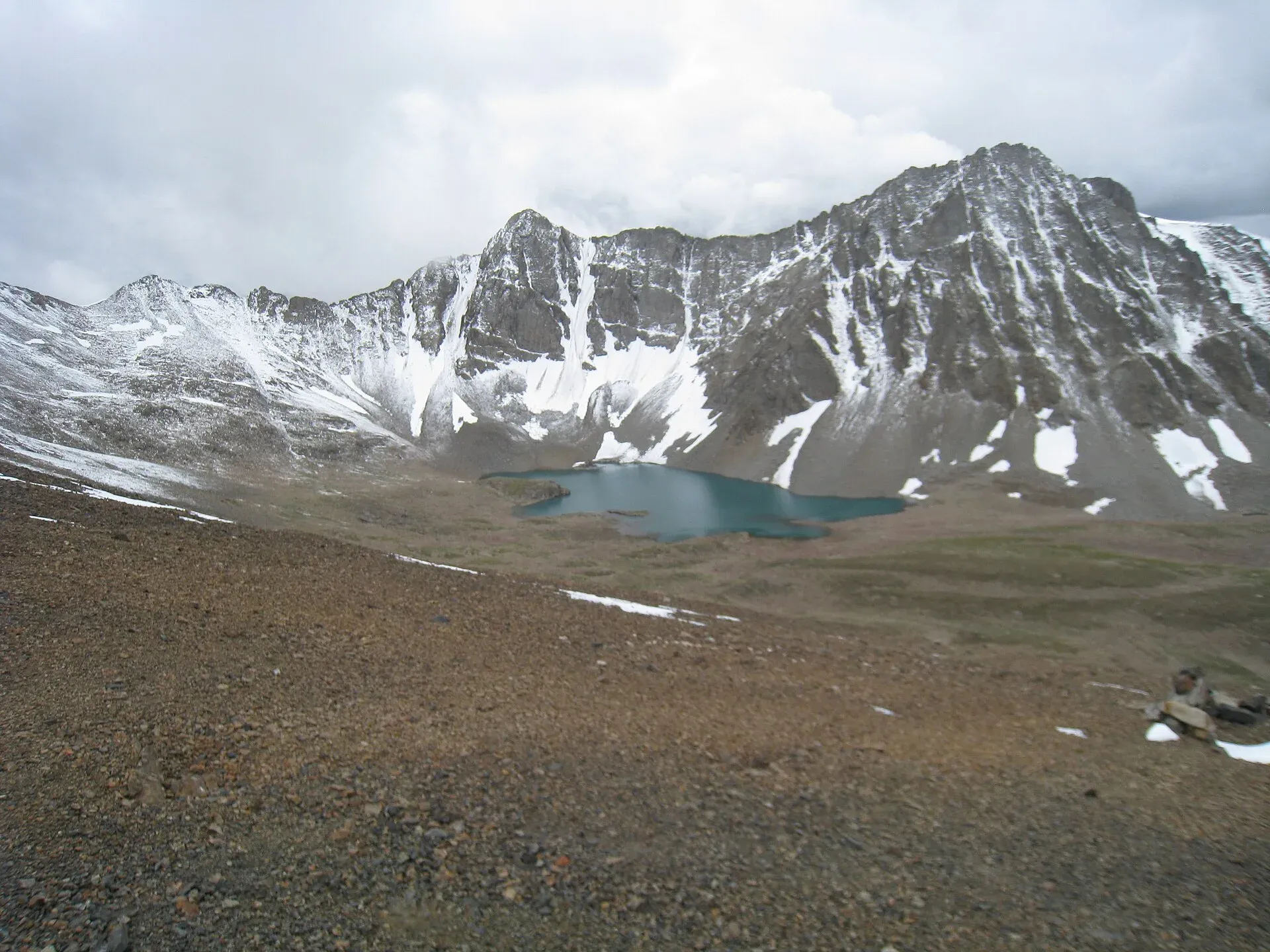
Photo: Ijaz024, with thanks · CC BY-SA 4.0 · via Wikimedia Commons · temporary stand-in photo

Burji La
- Duration
- 3 days
- Distance
- 39 km
- Grade
- Moderate
- Max altitude
- 4,816 m
- Season
- Jul – Sep
A three-day crossing of the 4,816 m Burji La from Skardu to the Deosai Plains, with distant views of K2 and the Baltoro peaks. Open-zone and moderate, but steep on day one.
Overview
The Burji La is a snow-covered pass between the Skardu valley and the Deosai Plains. It was part of the old British route between Srinagar and Skardu. Wikipedia and most operators give the height as 4,816 m, but other sources range from about 4,700 to 4,900 m. From the pass, only about 16 km south of Skardu and 2,600 m above it, you can see K2, the Gasherbrums and Masherbrum in the distance. The trek crosses the pass in three days and ends on the Deosai Plains.
Who it suits
A moderate trek for fit walkers with some experience. The first day is a long steady climb of about 1,500 m, so it suits people who are acclimatised or who can take it slowly. The pass is easier to cross from the Deosai side, and a university trip report warns that it is demanding. The old guide describes the route from north to south so that acclimatised trekkers can link it with the Deosai traverse.
When to go
Mid-June to mid-October by the old guide's reckoning. Snow lies on the pass early in the season, so crevasses may appear on the snowfield below the pass. By late summer the route is clearer, and the Deosai meadows are in flower in July and August.
The route
Burji is the first valley west of the broad Satpara valley. From the bridge over the Satpara stream, west of Skardu on the airport road, you reach the narrow opening of the Burji Nala in about 1½ hours. A herders' trail follows a clear stream past birch and willow. At Pindobal, herders' huts and a spring make a camp for people who are not yet acclimatised. The treeless camp site of Wozal Hadar (3,810 m) is about an hour further, and it is a good place to camp for the first night.
On day 2 the valley opens into a wide basin. The pass is the obvious snowy saddle on the east side of the ridge above the upper basin, two to three hours from Wozal Hadar. If crevasses show on the snowfield below the pass, use the rocky spur just to the west. A cairn marks the top. The giants at the head of the Baltoro rise above lower ridges, and to the south several icy blue lakes sit below a small ridge. You descend to the Burji Lungma (4,115 m) and follow it to a larger stream.
On day 3 you follow the stream south to the Deosai Plains and Ali Malik Mar, where a road meets the trail.
Underfoot
The first day is a herders' trail beside a clear stream, through birch and willow, then open ground with no trees at Wozal Hadar. Day 2 crosses a broad basin to a snow-covered saddle. Early in the season you may cross a snowfield with crevasses, so there is a rocky spur to the west as an alternative. The descent passes small blue lakes and meadow, then a stream valley to the Deosai Plains. Crampons or microspikes and an ice axe suit June, as the gear section says.
Deosai at the finish
The Deosai Plains lie at an average height of about 4,114 m and form a national park created in 1993 to protect the Himalayan brown bear. Wikipedia reports the bear population rising from 19 in 1993 to 78 in 2022. Himalayan marmots, golden eagles and lammergeiers also live there, and wildflowers cover the plateau in summer. The Balti name is said to mean "summer's place", because the plateau is reachable only in summer. Skardu is about 30 km from the plateau by the shortest route, and the Bara Pani is the largest river crossing it.
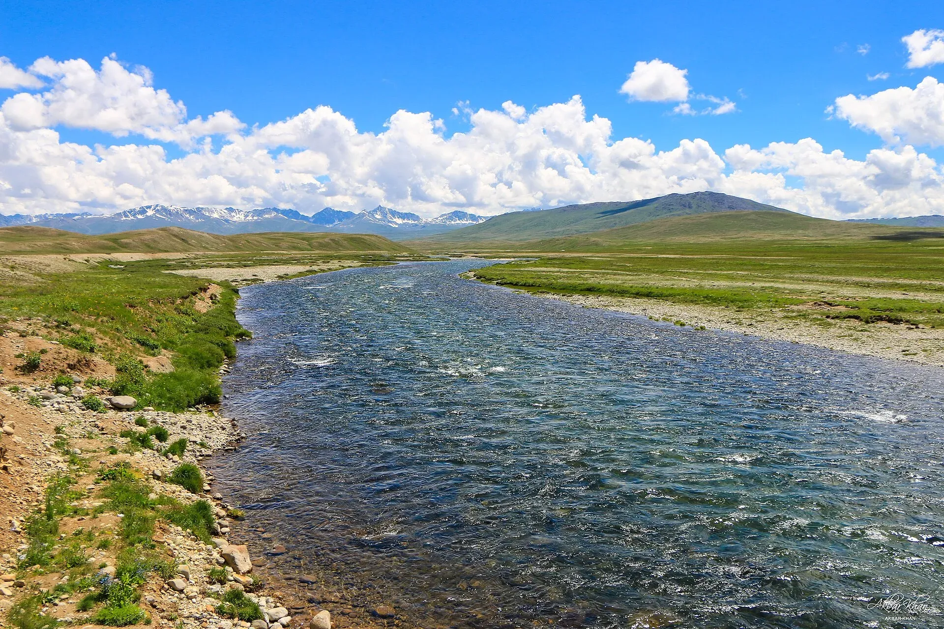
Photo: Akbar Khan Niazi, with thanks · CC BY-SA 4.0 · via Wikimedia Commons · temporary stand-in photo

Culture and people
The Deosai Plains have summer pastures used by herders from villages around Skardu. It was part of the old British route. Today you may meet shepherds on the plateau. The Burji valley is little visited, so carry what you need.
Practical information
Getting to the start. The start is a short jeep or walk from Skardu to the Satpara bridge. You can walk or take a Suzuki. At the finish there is no public transport. Walk or hitch to Satpara and Skardu, or head west to the Astor valley, or arrange a special hire in advance.
Deosai. The trek finishes on the edge of the Deosai plateau, which is a national park. Check for any entry fee and the dates the road is open with the park office or your operator.
Maps. The old guide recommends the US AMS 1:250,000 map Mundik (NI 43-3).
Combining. The trek links with the Deosai Traverse, the Katichu La and the Dari La; see Other treks in Baltistan.
Highlights
- Views of K2, the Gasherbrums and Masherbrum from the pass
- Icy blue lakes below the pass on the Deosai side
- Wild flower meadows on the Deosai Plains
- A short trek close to Skardu that links with longer Deosai routes
Day by day
- StartSkardu (Satpara bridge)
- Day 1Wozal Hadar
- Day 2Burji Lungma
- Day 3Ali Malik Mar
| Day | Route | Hours | Distance | Ascent / descent | Camp and altitude |
|---|---|---|---|---|---|
| Day 1 | Skardu to Wozal Hadar | 6–7 h | 20 km | +1,520 m | Wozal Hadar, 3,810 m |
Day 1 notesFrom the Satpara bridge reach the Burji Nala in about 1½ hours. A herders' trail follows the clear stream past birch and willow. Pindobal, with huts and a spring, is a camp three to four hours up. Wozal Hadar is another hour or so, on treeless ground. | |||||
| Day 2 | Wozal Hadar over the Burji La to Burji Lungma | 5–6 h | 9 km | +1,006 m / −701 m | Burji Lungma, 4,115 m |
Day 2 notesCross the wide basin to the snowy saddle, two to three hours away. Avoid crevasses on the snowfield by using the rocky spur to the west. A cairn marks the pass, with views to K2 and the Baltoro peaks. Descend south past icy blue lakes to the Burji Lungma. | |||||
| Day 3 | Burji Lungma to Ali Malik Mar | 3 h | 10 km | −183 m | not given |
Day 3 notesFollow the stream south to the Deosai Plains and the road at Ali Malik Mar. | |||||
Getting there
Start from Skardu. Walk or take a local Suzuki west towards the airport and the Satpara stream bridge. At the end, Ali Malik Mar is on the Deosai road, with no public transport. Hire a jeep in advance, or walk or hitch back to Satpara and Skardu, or on to Astor.
Permits and rules
- Permit needed
- Usually not, Open zone
- Fee
- Current fees will be added soon
- Last checked
- 16 November 2026
Zone: open. The old guide lists this trek as open-zone with no permit, and a Pakistan travel blog's summary of the 2024–25 rules says foreigners may trek in open zones without a permit. The trek is not in a restricted area. Rules and fees can change, so ask the Gilgit-Baltistan Tourism Department or your operator before you go.
How trekking permits, NOCs and registration work: Visa and permits.
Season
Best: Jul – Sep
Water and camps
There is a clear stream in the Burji Nala all the way to Wozal Hadar. Water is available in the upper basin and on the Burji Lungma. Pindobal has a spring. Wozal Hadar has no trees, so carry stoves.
Gear and safety
The pass is snow-covered for much of the season. Carry crampons or microspikes and an ice axe in June, and check for crevasses on the snowfield. The first day is long and steep, so carry plenty of water and start early. The pass is above 4,800 m, so watch for altitude sickness. Deosai weather is cold and changeable, with sudden storms.
Variations
- Deosai Traverse from Skardu to Astor, an easy walk of 4–5 days on the jeep road.
- Dari La and Katichu La from the Deosai side (see Other treks in Baltistan).
- Cross in reverse (south to north) from the Deosai side, which operators suggest is easier.
- Combine with the Baltoro viewpoints from the pass.
Tips
- Take it slowly on day one; you climb about 1,500 m.
- Pass height varies by source (4,700–4,900 m).
- Look for crevasses on the snowfield below the pass early in the season.
- Arrange your own transport at the finish; there is no public transport.
Stay and eat in Skardu
Skardu is the nearest town to the trek: somewhere to sleep and stock up before and after.
Places to stay
- Hotel Mashabrum Skardu, PakistanCall Hotel Mashabrum Skardu, PakistanMap of Hotel Mashabrum Skardu, Pakistan in Google Maps
- Himalaya Hotel SkarduCall Himalaya Hotel SkarduMap of Himalaya Hotel Skardu in Google Maps
- Baltistan Continental Hotel Skardu,Baltistan PakistanCall Baltistan Continental Hotel Skardu,Baltistan PakistanMap of Baltistan Continental Hotel Skardu,Baltistan Pakistan in Google Maps
- Avari Xpress Skardu HotelCall Avari Xpress Skardu HotelMap of Avari Xpress Skardu Hotel in Google Maps
- Baltistan ResortMap of Baltistan Resort in Google Maps
- Skardu Arcadian ResortCall Skardu Arcadian ResortMap of Skardu Arcadian Resort in Google Maps
Places to eat
- Shahi DewanCall Shahi DewanMap of Shahi Dewan in Google Maps
- Rafsal restaurantCall Rafsal restaurantMap of Rafsal restaurant in Google Maps
- Dewan-e-Khas Hotel & RestaurantCall Dewan-e-Khas Hotel & RestaurantMap of Dewan-e-Khas Hotel & Restaurant in Google Maps
- The Grind Cafe and Eatery, SkarduCall The Grind Cafe and Eatery, SkarduMap of The Grind Cafe and Eatery, Skardu in Google Maps
- Balti Cuisine SkarduCall Balti Cuisine SkarduMap of Balti Cuisine Skardu in Google Maps
- Bismillah Bakery - SkarduCall Bismillah Bakery - SkarduMap of Bismillah Bakery - Skardu in Google Maps
Essential services fuel stations, mechanics, ATMs, banks, pharmacies and hospitals and clinics
Fuel
- Saltoro Petrol PumpCall Saltoro Petrol PumpMap of Saltoro Petrol Pump in Google Maps
- Total Petrol Filling StationCall Total Petrol Filling StationMap of Total Petrol Filling Station in Google Maps
- Sadpara Filling Station - TOTAL Parco Petrol PumpCall Sadpara Filling Station - TOTAL Parco Petrol PumpMap of Sadpara Filling Station - TOTAL Parco Petrol Pump in Google Maps
- Haji Akbar Petrol PumpMap of Haji Akbar Petrol Pump in Google Maps
- SKURDU FILLING STATION- Total Petrol StationCall SKURDU FILLING STATION- Total Petrol StationMap of SKURDU FILLING STATION- Total Petrol Station in Google Maps
- IRFAN WAZIR & SONS FILLING STATION (BYCO Filling station)Call IRFAN WAZIR & SONS FILLING STATION (BYCO Filling station)Map of IRFAN WAZIR & SONS FILLING STATION (BYCO Filling station) in Google Maps
Mechanics and tyre shops
- Wali Imtiaz Autos (Wali Ustad)Call Wali Imtiaz Autos (Wali Ustad)Map of Wali Imtiaz Autos (Wali Ustad) in Google Maps
ATMs
- Askari BankCall Askari BankMap of Askari Bank in Google Maps
- Bank Al Habib And ATMMap of Bank Al Habib And ATM in Google Maps
- UBL Bank Skardu and ATMMap of UBL Bank Skardu and ATM in Google Maps
- Allied Bank and ATM SkarduMap of Allied Bank and ATM Skardu in Google Maps
- HBL Alamdar Chowk BranchMap of HBL Alamdar Chowk Branch in Google Maps
Banks and money exchange
Pharmacies
- Zaheer Chemist&surgical storeMap of Zaheer Chemist&surgical store in Google Maps
Hospitals and clinics
- DOLTI HOSPITAL SKARDUCall DOLTI HOSPITAL SKARDUMap of DOLTI HOSPITAL SKARDU in Google Maps
- Doctors Hospital SkarduCall Doctors Hospital SkarduMap of Doctors Hospital Skardu in Google Maps
- Hussain Memorial Hospital SkarduCall Hussain Memorial Hospital SkarduMap of Hussain Memorial Hospital Skardu in Google Maps
- FE&MT Eye Care CenterCall FE&MT Eye Care CenterMap of FE&MT Eye Care Center in Google Maps
Listings come from Google Maps data and are unverified: phone numbers, opening months and prices may have changed. Report a problem · Own one of these? Claim it
Photos we still need: Burji Nala trail, Wozal Hadar and the pass (the new route photo shows only the approach). Send us yours
Health and emergency
Mobile signal is patchy on most treks, so tell someone your plan before you go. Emergency numbers
Sources and last checked
Last checked Confidence medium5 sources5 still to check
- Last checked
- Method
- Desk research from published sources
- Confidence
- medium
- Checked by
- trek.pk research team
Researched from published sources; not yet checked on the ground by our team. Spot something out of date? Report a mistake.
Sources
- Burji La (old trek.pk page, text from Lonely Planet Trekking in the Karakoram and Hindukush, c. 2002; used for facts only) · trek.pk / Lonely Planet · checked
- Burji La · Wikipedia · checked
- Burji La Trek (operator page) · Apricot Tours · checked
- Procedure for Applying for Permission 2024-25 · Pakistan Travel Blog · checked
- Deosai National Park (altitude, bears, wildlife, name) · Wikipedia · checked
Still to be checked on the ground (5)
- Pass height: we use 4,816 m (Wikipedia, Great Karakoram/Pyara Skardu pages); operator pages vary from 4,700 m to 4,880 m (Apricot Tours gives both on one page)
- Day 1 and 2 timings (from c. 2002 guide); Apricot Tours gives about 3 to 4 hours for the final ascent on its own route, which is not directly comparable
- Whether any Deosai National Park fee or permit applies on the Deosai side (no official fee notice found)
- Current availability of local transport at the Satpara bridge and Ali Malik Mar
- Road to Ali Malik Mar and its opening dates
Nearby and related

Other treks in Baltistan

Thalle La

Asumbar Haghost
Burji La
A snow-covered pass of about 4,816 m between Skardu and the Deosai Plains, with distant views of K2 and the Baltoro peaks. A moderate three-day trek.
Dari La
A demanding trekking pass of about 4,724 m between Shigarthang and the Deosai Plains, crossed in three days. Little information published.
Katichu La
A moderate trekking pass of about 4,588 m between Mehdiabad on the Indus and the Deosai Plains, usually snow-free from July to late September.